Tag: Maps

USGS Topographic Map-Grand Canyon

USGS Topographic Maps

With the USGS Topographic Map in hand, I felt like a modern-day explorer, navigating through the rugged terrain with ease. The level of detail was astounding. Learn more about USGS Topographic Maps and discover the thrill of adventure.
Read More »
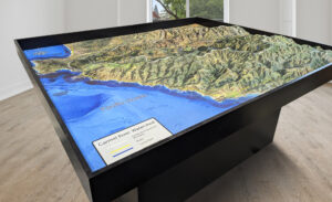
6-foot by 7-foot 3D terrain map of the Carmel River Watershed created for Monterey Peninsula Regional Park District, featuring satellite hybrid imagery, a waterproof surface, and an ADA-accessible pedestal base.

Raised Relief Map of Monterey Peninsula Park

Learn more about raised relief maps and how they can provide a powerful tool for visualizing and understanding landscapes. Check out this stunning 42 square foot raised relief map of Monterey Peninsula Regional Park District, which was built using cutting-edge technology, including 3D printing and vinyl overlays. Raised relief maps have a wide range of applications, from outdoor recreation and education to scientific research and urban planning.

Read More »
Alaska Physical Map

Raised Relief Maps

The raised relief map brought the mountains to life, with their peaks and valleys seemingly jumping off the page. It was a tactile experience like no other. Learn more about Raised Relief Maps and explore the world with your hands.

Read More »
Ohio Watershed Streams

Ohio Watershed Maps

Unearth the secrets of Ohio’s intricate watersheds! From the sprawling Ohio River Basin to the majestic Lake Erie Basin, discover the lifelines that sustain the state’s ecology and economy. Dive into challenges, triumphs, and the spirited conservation efforts safeguarding these waterways. Join us on this riveting journey through Ohio’s liquid heart!

Read More »
Texas Watershed Streams

Texas Watershed Maps

Journey through Texas’s vast landscapes via its intricate watersheds! From the Rio Grande’s mysteries to the Colorado River’s vitality, uncover the Lone Star State’s water tapestry, its challenges, and the passionate efforts to preserve it. Dive in and discover the liquid heartbeat of Texas!

Read More »
Chesapeake Bay Watershed with Streams

Chesapeake Bay Watershed Maps

Dive into the heart of America’s largest estuary—Chesapeake Bay! Navigate its sprawling watershed, from mighty rivers to delicate ecosystems. Discover the bay’s profound significance, the looming challenges it faces, and the passionate efforts safeguarding its future. Join this enlightening journey through maps, history, and nature!

Read More »
Colorado Watershed Streams

Colorado Watershed Maps

Journey through Colorado’s majestic watersheds! From the mighty Colorado River to the sprawling plains, uncover the essence of the Centennial State’s waterways. Explore their vital role in ecology, economy, and culture, and discover the passionate efforts safeguarding these precious veins. Dive in and let the waters of Colorado captivate you!

Read More »
Mississippi Watershed Streams

Mississippi Watershed Maps

Journey down the mighty Mississippi Watershed! Discover its vast expanse, from pristine wetlands to historical banks. Delve into challenges it faces and the passionate efforts safeguarding this aquatic treasure. Embark on an adventure that flows through the heart of America!

Read More »
Great Lakes Watershed Streams

Great Lakes Watershed Maps

Journey through the heart of North America with the Great Lakes Watershed Maps! Uncover ecological secrets, historical tales, and the urgent call for conservation. Discover how these freshwater giants shape our world, from bustling economies to vibrant ecosystems. Dive in and let the waves of knowledge wash over you!

Read More »
New York-Hudson Watershed Streams

New York Watershed Maps

Uncover the secrets of New York’s watersheds, from the majestic Hudson River to the tranquil Finger Lakes. Discover how intricate maps reveal their vast importance, the challenges they face, and the efforts underway to preserve these lifelines. Dive into a tale where nature, history, and human endeavor converge in the Empire State’s aquatic pathways.

Read More »

Arches National Park 3D Maps

Step into a virtual realm of red rock wonders. Arches National Park’s iconic arches and landscapes come alive with 3D maps, revealing the secrets of geological artistry. Traverse canyons, stand beneath towering arches, and feel the sun’s warmth on your skin, all from the comfort of your home. Get ready for an adventure beyond imagination in the heart of Utah’s desert marvel!

Read More »

Yellowstone National Park 3D Maps

Experience the heart-pounding beauty of Yellowstone National Park like never before with our captivating 3D art. Dive into the park’s breathtaking landscapes, majestic wildlife, and legendary geothermal wonders, all brought to life in exquisite detail. Get ready to embark on an adventure that transcends time and space.

Read More »

Zions National Park 3D Maps

Step into the heart of Zion National Park’s majestic landscapes like never before. Our stunning 3D art captures the park’s raw beauty, immersing you in its awe-inspiring canyons, soaring cliffs, and lush oases. Experience Zion’s natural wonders from a whole new perspective – it’s a visual journey that brings the wild spirit of the park to life.

Read More »

Catamount Ski Area 3D Maps

Discover Catamount Ski Area like never before with immersive 3D maps! Navigate its scenic trails, from gentle beginner slopes to challenging black-diamond runs. These detailed maps bring the mountain to life, helping you plan your adventure, explore the terrain, and make the most of your skiing experience at this East Coast gem on the Massachusetts-New York border!

Read More »

Sugar Hill 3D Maps

Sugar Hill 3D Maps bring the Adirondacks to life, showcasing every thrilling run and serene glade. From gentle beginner slopes to heart-pounding black diamonds, these maps capture the adventure and beauty of this stunning resort. Experience the excitement of skiing through breathtaking landscapes and navigate the mountain like never before with these immersive and detailed 3D maps!

Read More »

Get a Free Quote