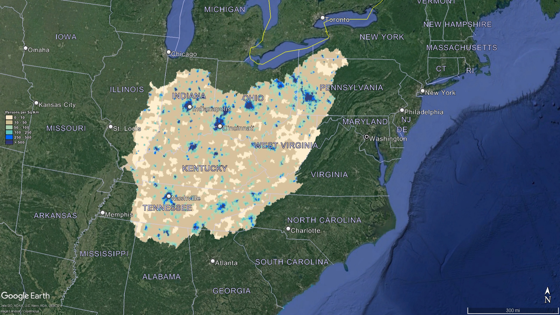
Ohio Watershed Maps
Ohio Watershed Maps
We Build Custom 2D & 3D Ohio Watershed Maps
Did you know we make
custom
3D Watershed Maps

Ohio Watershed Maps
The state of Ohio, known for its historical significance, bustling cities, and breathtaking landscapes, has a natural resource wealth that goes largely unheralded. Among the many environmental riches it possesses, Ohio’s watersheds stand out as critical to the state’s ecology, economy, and well-being of its residents.
Understanding the Vital Role of Watersheds
Before immersing ourselves in the depths of the Ohio watershed map’s complexities, it’s imperative to establish a foundational understanding of what precisely a watershed is and why it’s of such paramount importance. At its core, a watershed is a distinct geographical area where all the rainwater, melted snow, or any other form of precipitation eventually gets funneled and drained into a single, larger body of water. This could be a winding river, a serene lake, or a babbling stream. Essentially, imagine a vast funnel where every single droplet of water, no matter where it originates from within that funnel, will invariably find its way to a specific exit point. This inherent feature of watersheds makes them indispensable in managing and directing our invaluable water resources.
In the context of Ohio, with its diverse landscape and economic activities, watersheds assume a role of even greater significance, serving multiple critical functions:
- Water Provision: They are the lifeblood of the state’s water needs. Whether it’s for irrigating vast stretches of farmland, serving the demands of burgeoning industries, or simply catering to the daily needs of households, watersheds ensure a consistent and reliable supply of water.
- Biodiversity Hubs: Beyond just channeling water, watersheds act as vibrant ecosystems, teeming with life. They are havens for a vast array of aquatic species, and their banks and surrounding areas provide habitats for numerous terrestrial creatures. Their role in maintaining the state’s ecological balance cannot be overstated.
- Centers of Recreation: The pristine lakes, rivers, and streams flowing from these watersheds are not just sources of life; they’re also sources of leisure. They form the backdrop for many recreational activities that Ohioans cherish, from tranquil fishing expeditions and exhilarating boating adventures to refreshing swims on hot summer days.
- Economic Cornerstones: The health and vitality of watersheds have direct economic ramifications. A robust and thriving watershed translates to a stable water supply, which, in turn, ensures that sectors heavily reliant on water, such as agriculture and tourism, can flourish. In this sense, the prosperity of Ohio’s watersheds is inextricably linked to the prosperity of the state itself.
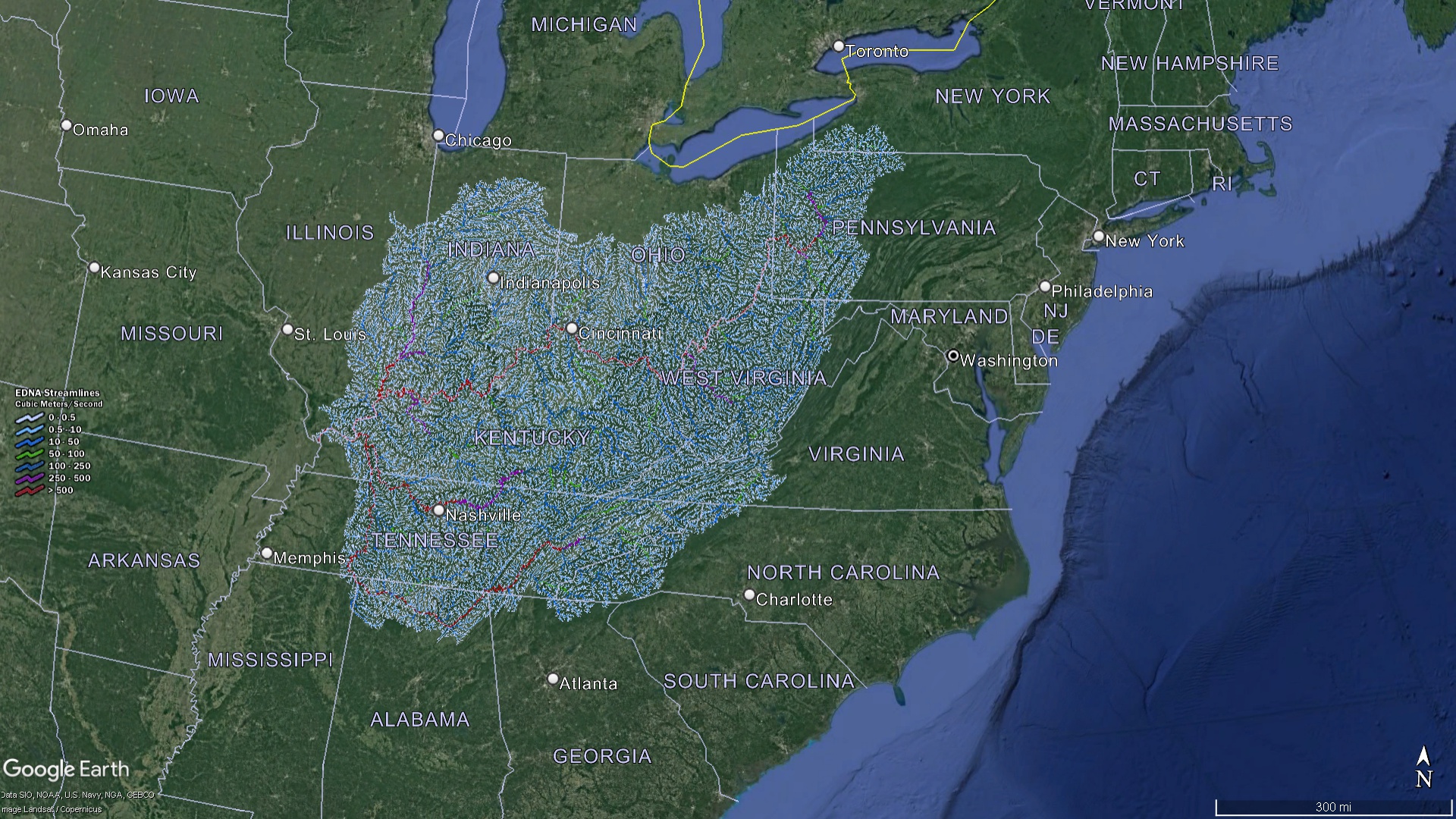 Ohio Watershed Streams
Mapping Ohio’s Watersheds
Ohio’s vast and diverse landscape is beautifully intertwined with a network of watersheds, each playing a pivotal role in the state’s ecological and hydrological balance. The Ohio watershed map serves as an exhaustive and detailed guide, capturing the essence of these vital waterways. It meticulously illustrates every nook and cranny, from the grandeur of the major basins to the intricacies of smaller sub-watersheds. Let’s embark on a deeper exploration of some of the state’s most prominent watersheds and the treasures they hold.
Lake Erie Basin
Dominating the northern fringes of Ohio, the Lake Erie Basin confirms the state’s connection with one of the Great Lakes. It acts as a funnel, guiding the waters from its terrain directly into the vast expanse of Lake Erie. Key rivers carving their paths within this basin are the iconic Cuyahoga, the winding Maumee, and the picturesque Sandusky. These rivers, along with countless smaller tributaries, feed the basin, contributing to its vibrancy and significance.
Ohio River Basin
A behemoth in terms of its coverage, the Ohio River Basin stretches across southern and eastern Ohio, painting a vivid picture of the state’s hydrological diversity. It serves as a colossal drainage mechanism, channeling waters from myriad sources and ultimately pouring them into the majestic Ohio River. Notable rivers enhancing the richness of this basin include the tranquil Scioto, the rugged Hocking, and the serene Little Miami. Together, they create a harmonious blend of flow patterns and ecological niches.
Muskingum River Basin
Nestled in the eastern part of the state, the Muskingum River Basin holds the distinction of being Ohio’s most expansive drainage system. Its vastness encompasses several rivers, with the Walhonding and Tuscarawas standing out due to their length and ecological importance. This basin is a mosaic of diverse habitats and water flow dynamics, making it a focal point for environmentalists and hydrologists alike.
Great Miami River Basin
Carving its way through western Ohio, the Great Miami River Basin is a confirmation to the state’s geological past and hydrological evolution. While it may not be the largest, its significance cannot be understated. The basin eventually merges with the Ohio River, but not before creating a labyrinth of streams, rivers, and tributaries. It’s a microcosm of Ohio’s waterways, capturing the essence of the state’s relationship with its most vital resource: water.
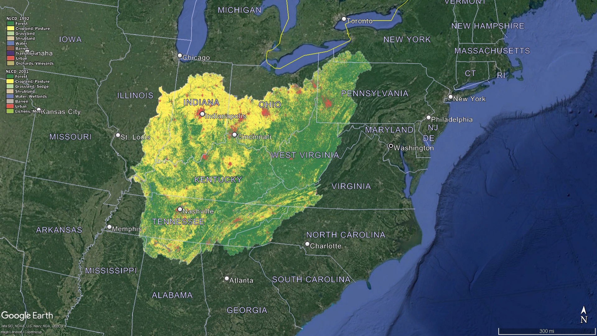 Ohio Watershed Land Characteristics
Sample 3D Watershed Maps
The Details Within the Ohio Watershed Map
While the broad categorization helps in a general understanding, the Ohio watershed map delves much deeper. Each major basin is broken down into sub-watersheds or smaller drainage areas. These can further be divided into even smaller categories, sometimes referred to as ‘catchments’ or ‘drainage basins’. Each division is integral for local water management strategies and understanding the hydrological flow within the state.
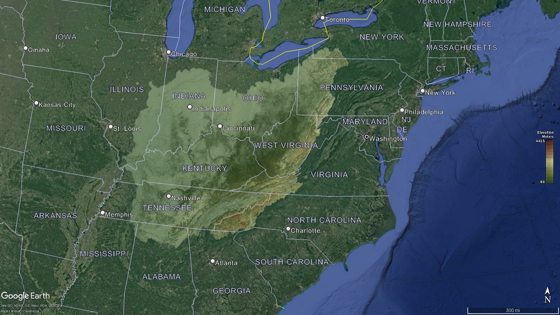 Ohio Watershed Elevation
Deepening Concerns: Threats to Ohio’s Watersheds
Ohio’s watersheds, much like vital aquatic systems across the globe, confront a myriad of challenges. These threats, stemming from both natural phenomena and human activities, can deeply impact the health and functionality of these watersheds:
Pollution: The rapid pace of industrial growth, coupled with intensive agricultural practices and expanding urban areas, has ushered in heightened levels of pollution within many of Ohio’s watersheds. Pollutants from factories, harmful chemicals from agricultural runoff, and waste from urban regions find their way into these water bodies. Such contamination not only compromises the purity of the water, making it unsafe for consumption, but also poses a severe threat to the diverse aquatic life dependent on these waters for survival.
Deforestation: As expansive forested areas are cleared to pave the way for urban expansion or to meet the ever-growing demands of agriculture, the natural rhythm of watersheds is disrupted. Forests play a vital role in maintaining soil structure and preventing erosion. Their removal can lead to significant soil erosion, resulting in excessive sedimentation in rivers and streams. This alteration can disrupt aquatic habitats and affect the clarity and quality of water.
Climate Change: The looming shadow of climate change has far-reaching effects on watersheds. Changes in traditional rainfall patterns can lead to unpredictable water flow within these systems. Moreover, as global temperatures rise, the rate of evaporation from these water bodies can intensify, leading to reduced water levels, which in turn, affects the availability of water for various purposes.
 Ohio Watershed Population
Conservation Efforts
Acknowledging the unparalleled importance of watersheds for both ecological balance and human sustenance, there’s been a concerted push towards their preservation and rejuvenation:
Education & Awareness: Grassroots movements led by local communities, proactive initiatives by educational institutions, and concerted campaigns by non-profit organizations have made significant strides in raising awareness about watersheds. Through workshops, seminars, and field trips, they elucidate the importance of watersheds, the threats they face, and the collective measures that can be adopted to safeguard them.
Restoration Projects: Across Ohio, there’s a renewed focus on projects aimed at restoring the natural vitality of watersheds. These endeavors, whether spearheaded by government bodies or passionate environmentalists, focus on rehabilitating habitats, curbing pollution sources, and initiating large-scale reforestation drives. The goal is to reverse some of the damages inflicted over the years and ensure that watersheds can continue to thrive.
Legislation and Policy Framework: Recognizing the need for structured interventions, legislative measures have been put in place at both state and federal levels. These laws and regulations are designed to offer protection to ecologically sensitive watershed areas, set limits on permissible pollution levels, and ensure that water extraction and usage occur within sustainable limits. Effective enforcement of these regulations is crucial to ensure the longevity and health of Ohio’s watersheds.
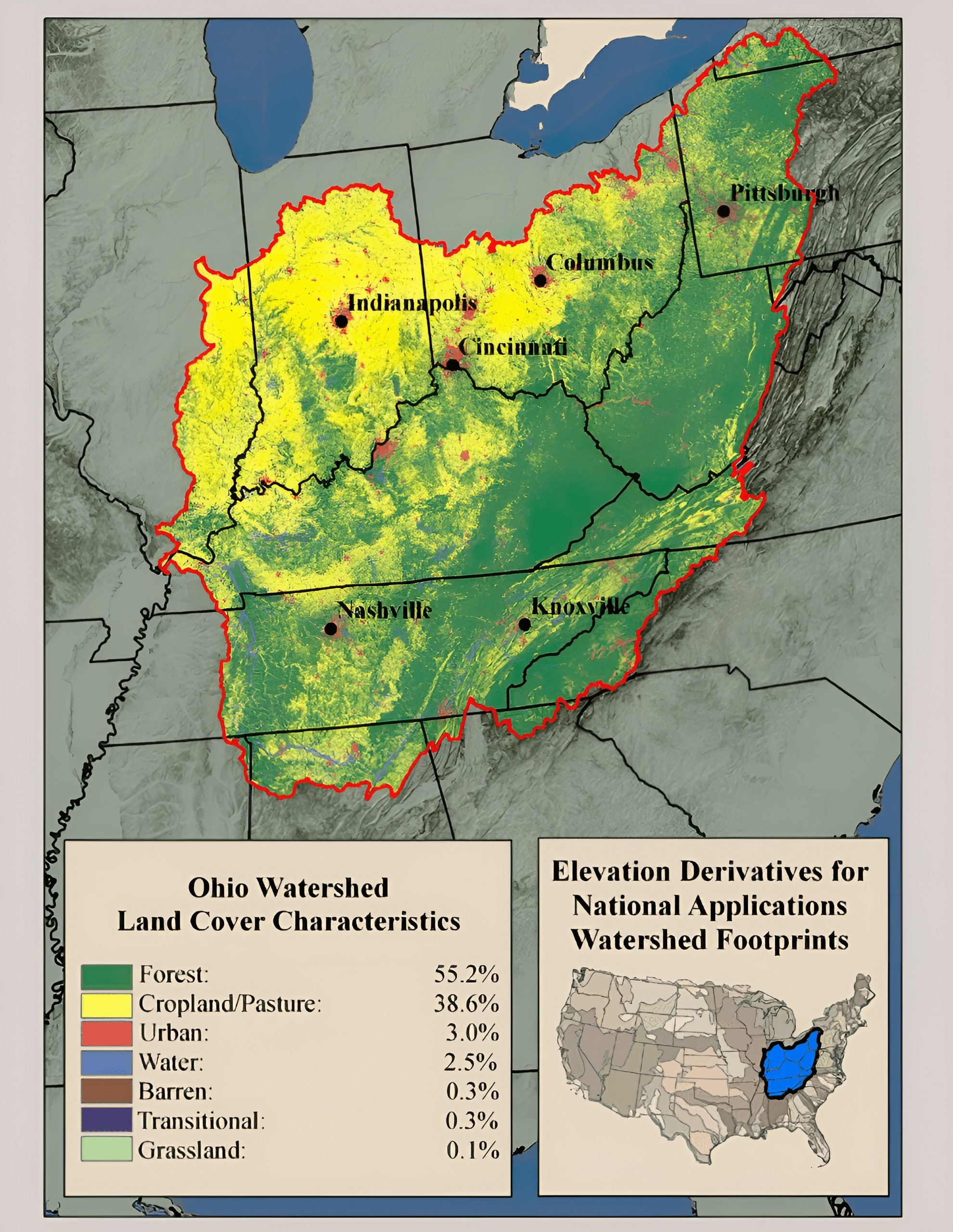 Ohio Watershed Land Percentages
The Ohio watershed map isn’t just a representation of the state’s hydrological flow. It is a mixture of Ohio’s intricate natural systems, connecting land, water, and life in a complex dance of interdependence. As challenges like climate change and urbanization continue to evolve, understanding and protecting these watersheds becomes even more crucial. Through a combination of awareness, action, and policy, Ohio can ensure that its watersheds remain vibrant, healthy, and capable of supporting the state’s diverse needs for generations to come.
Check out our Watershed Maps for more information on Ohio Watershed Maps. You can also learn more at our 3D Maps Learning Center.
Contact us today to learn more about our 3D services and how we can help you achieve your goals.
