Yellowstone National Park 3D Maps

We Build Custom 2D and 3D National Park Maps

Did you know we make

custom

3D raised-relief maps

park city utah ski custom 3d map

and

3D national park maps

Yellowstone Old Faithful 3D Map

Exploring Yellowstone National Park’s Geological Wonders with 3D Maps

Nestled in the heart of the American West, Yellowstone National Park confirms the Earth’s unrivaled natural beauty and geological marvels.  This iconic park, renowned for its mesmerizing geothermal features, diverse wildlife, and expansive landscapes, has captivated adventurers and nature enthusiasts for over a century. However, a new dimension of exploration awaits those who seek to delve deeper into Yellowstone’s mysteries through the power of 3D maps.  In this comprehensive article, we will embark on an extensive journey through the history, geology, and wonders of Yellowstone National Park, while exploring how 3D maps can revolutionize our understanding and appreciation of this unique destination.

Yellowstone’s Unique Geological History

Yellowstone National Park, founded in 1872, holds a double distinction as both the United States’ and the world’s inaugural national park.  Encompassing a vast expanse of over 2.2 million acres across three states—Wyoming, Montana, and Idaho—it cradles a treasure trove of natural wonders.  Our journey begins with a deep dive into the park’s geological history, a story etched in stone and shaped by the unfathomable forces of the Earth.

The Yellowstone Caldera: A Geological Marvel

At the core of Yellowstone’s geological wonders lies the enigmatic Yellowstone Caldera, an ancient supervolcano that has cast an indelible imprint on the park’s singular topography.  With the aid of 3D maps, visitors are granted an awe-inspiring perspective on the grandeur of this colossal caldera and its profound role in shaping Yellowstone’s landscape over epochs.

These meticulously crafted 3D maps illuminate the intricate details of the caldera, revealing its sprawling dimensions and the subtle intricacies of its geological features.  The caldera, which spans an astounding 45 by 30 miles, confirms the Earth’s tumultuous past and the raw power lurking beneath the park’s serene surface. It is a geological marvel that leaves observers humbled by the sheer magnitude of nature’s forces at play.

Yellowstone Old Faithful 3D Map 
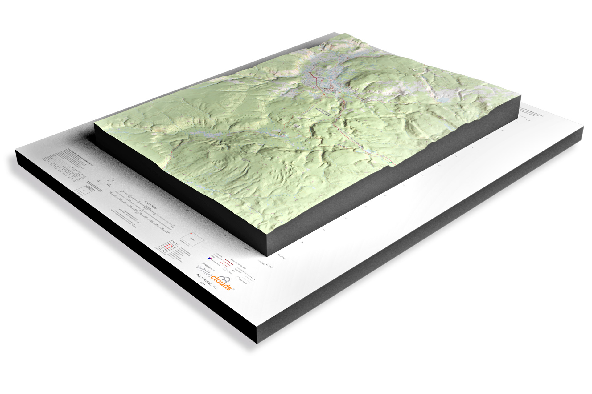
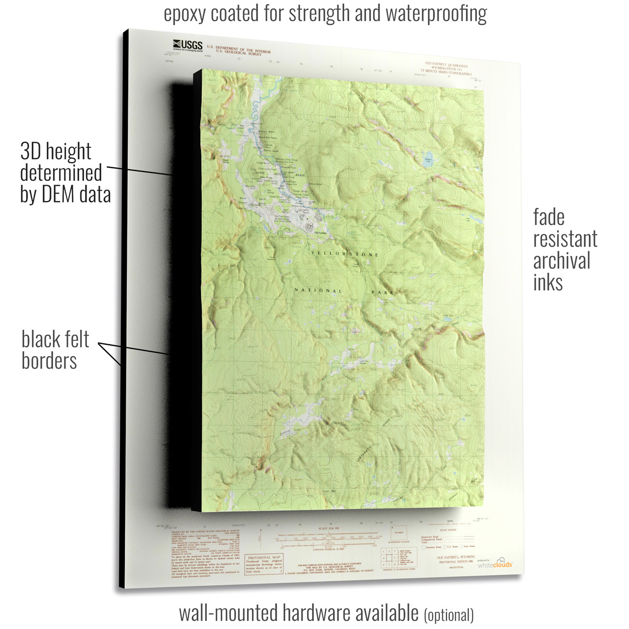
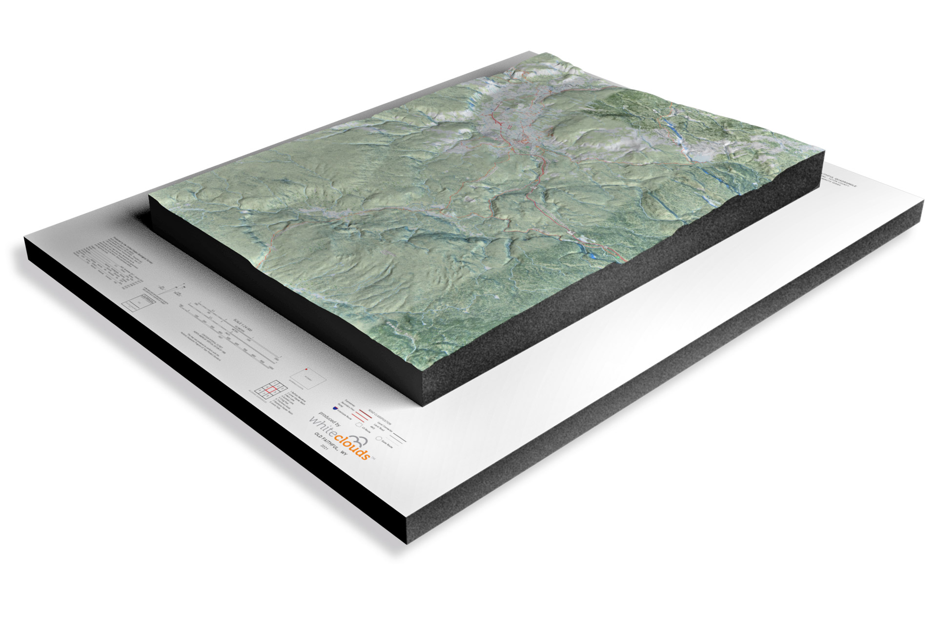
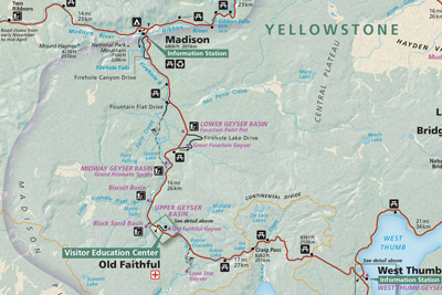
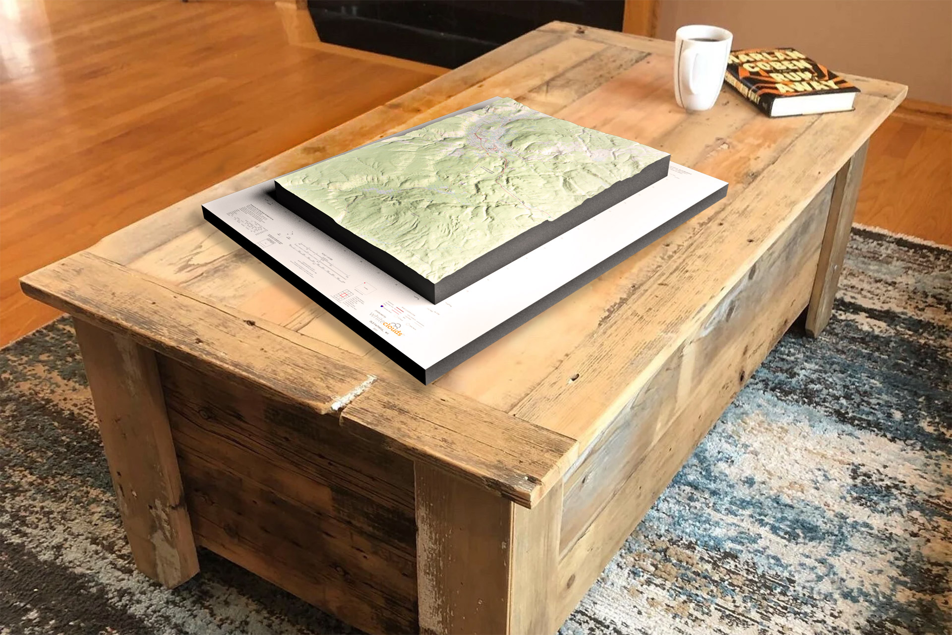
Yellowstone National Park – USGS 3D Raised Relief Map of Old Faithful

Geothermal Spectacles: Old Faithful and Beyond

Yellowstone’s geothermal wonders, including the legendary Old Faithful geyser, take on a mesmerizing new dimension when viewed through the lens of 3D mapping.  These maps serve as guides into the subterranean world, unveiling the hidden plumbing system that orchestrates the dramatic eruptions of Old Faithful and its counterparts.

As visitors explore the intricacies of these 3D maps, they are treated to an intimate glimpse of the subterranean geothermal plumbing that powers the park’s captivating displays.  The delicate balance of pressure, heat, and water is laid bare, offering an unprecedented appreciation of the natural processes orchestrating these geothermal spectacles.  From the rhythmic spouting of geysers to the vibrant hues of bubbling hot springs and the primal, churning mud pots, 3D visualization unveils the intricacies at work beneath the Earth’s surface, showcasing nature’s artistry in its most primal form.

Moreover, these maps extend beyond Old Faithful, allowing visitors to uncover lesser-known geothermal gems tucked away in Yellowstone’s corners.  Each of these hydrothermal features, whether famous or hidden, contributes to the park’s geological tapestry, providing a deeper understanding of the dynamic forces shaping the landscape.

Yellowstone Old Faithful 3D Satellite Map 
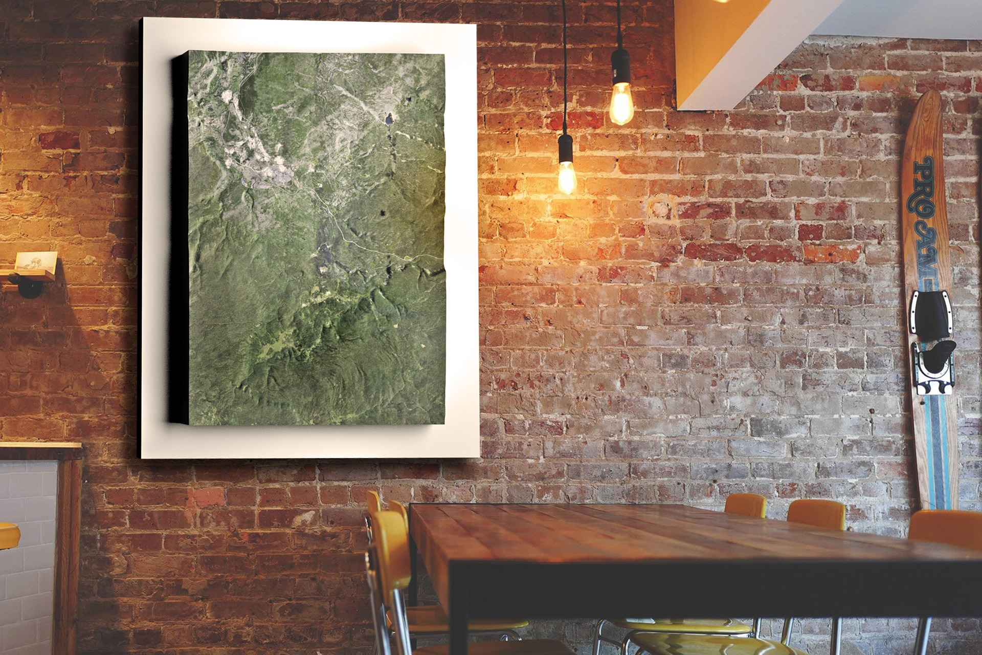
Yellowstone National Park – 3D Satellite Map of Old Faithful 

The Evolution of 3D Mapping: Yellowstone’s Geological Revelation

The march of technology has ushered in a new era of exploration, one where our understanding of natural wonders like Yellowstone National Park has reached unprecedented depths.  Traditional maps and photographs, though invaluable, are yielding the spotlight to a groundbreaking innovation – 3D mapping technology.  This revolutionary tool not only enhances navigation but also offers a profound insight into the intricate landscapes within Yellowstone and the world of geology it encapsulates.

Unveiling the Essence of 3D Mapping

At its core, 3D mapping technology is a harmonious blend of science and artistry.  It amalgamates satellite imagery, aerial photography, and meticulous ground-level data collection to craft highly detailed, three-dimensional representations of the terrain.  These physical models transcend the realm of mere paper maps or digital renderings, opening up new horizons for exploration and comprehension.

Capturing Yellowstone’s Majestic Terrain

Traditional topographic maps, while informative, can often fall short in conveying the full essence of a landscape as grand as Yellowstone’s.  In stark contrast, 3D maps breathe life into the geography they represent.  Picture holding in your hands a tangible representation of Yellowstone’s towering mountain ranges, meandering rivers, and dramatic geothermal features.  These models provide an unparalleled tactile experience, allowing you to intimately connect with the landscape even before you set foot within the park’s boundaries.

The Magic of Immersive Exploration

The true beauty of 3D maps lies in their capacity to transcend the limitations of two dimensions.  They bridge the gap between observer and observed, transporting you into the heart of Yellowstone’s geological wonders. With 3D maps, you can trace the undulating contours of Mount Washburn, feeling the elevation changes as if you were hiking to its summit.  You can virtually traverse the intricate patterns of Yellowstone Lake’s shoreline, gaining a palpable sense of the lake’s vastness.  This immersive quality is not just awe-inspiring; it’s also an invaluable tool for planning hikes, assessing challenges, and ensuring safe and unforgettable adventures.

Understanding the Forces That Shaped Yellowstone

Furthermore, 3D maps offer a unique opportunity to grasp the geological forces that have sculpted Yellowstone National Park.  As you run your fingers over the models, you can visualize the eons of volcanic activity, erosion, and tectonic forces that have shaped these remarkable landscapes.  The tactile nature of these maps allows for a deeper connection with the natural processes that created the park’s geysers, hot springs, canyons, and geothermal wonders.

Conservation Through Tangibility

Beyond their role as exploration aids, physical 3D maps serve a vital purpose in conservation efforts.  Park rangers and researchers utilize these models to better understand and monitor the park’s ever-changing landscapes.  The tangible nature of these maps facilitates hands-on training and the exchange of knowledge among conservationists, ensuring that Yellowstone National Park remains a pristine sanctuary for generations to come.

In essence, 3D mapping technology transcends the digital realm, offering a tangible and immersive way to connect with the geological masterpiece that is Yellowstone National Park.  These physical models serve as portals to a deeper understanding of the landscape’s intricacies, the forces that have shaped it, and the profound beauty that makes Yellowstone a natural treasure worthy of preservation.

How 3D Maps Are Made: Unveiling the Magic Behind the Scenes

3D maps have revolutionized the way we navigate and explore the world around us, offering immersive and detailed representations of landscapes, cities, and natural wonders.  But have you ever wondered how these intricate 3D maps are created?  Let’s take a peek behind the curtain to uncover the magic of 3D map-making.

Data Acquisition: The Foundation of 3D Maps

At the core of any 3D map creation process is the acquisition of spatial data.  This data forms the foundation upon which the 3D map is built.  Several methods are commonly employed to gather this crucial information:

  • Aerial Imagery:  Aerial photography and remote sensing techniques, including LiDAR (Light Detection and Ranging), capture high-resolution images and elevation data from airplanes or drones.  LiDAR, in particular, provides detailed 3D point cloud data by measuring the distance between the sensor and the Earth’s surface.

  • Satellite Imagery:  Satellite-based remote sensing technologies collect vast amounts of data covering large areas.  This data includes color imagery, infrared imagery, and elevation data, allowing for a comprehensive view of the terrain.

  • Ground-Based Surveys:  Surveyors use terrestrial LiDAR scanners, GPS technology, and other instruments to collect precise data from the ground. This data is often used to complement and refine aerial or satellite data.

Data Processing: Transforming Raw Data into 3D Models

Once the raw data is collected, it undergoes extensive processing to convert it into usable 3D models.  This processing includes:

  • Data Alignment:  Merging data from various sources and ensuring that it is accurately aligned in a common coordinate system is a crucial step.  This alignment ensures that the 3D map accurately represents the real-world terrain.

  • Point Cloud Processing:  For LiDAR data, point clouds are generated, where each point represents a specific location in 3D space.  Filtering and classification algorithms are used to separate ground points from non-ground points (such as vegetation or buildings).

  • Mesh Generation:  To create a more detailed 3D representation, the point cloud is converted into a mesh.  This mesh consists of interconnected triangles that form the surface of the terrain.

  • Texture Mapping:  Aerial and satellite images are draped onto the 3D mesh to provide color and texture, making the map visually appealing and realistic.

Visualization and Interaction: Making 3D Maps User-Friendly

Creating a 3D map is not just about data; it’s about making it accessible and user-friendly. Here’s how:

  • User Interface Design:  Designing an intuitive user interface is crucial to allow users to interact with the 3D map effectively.  This includes navigation controls, search functions, and overlay options.

  • Web-Based Platforms:  Many 3D maps are accessible through web-based platforms or dedicated apps, making them available to a wide audience via computers, smartphones, and tablets.

  • Customization:  Users often have the ability to customize their 3D map experience by choosing different layers, map styles, and viewing options to suit their needs and preferences.

3D maps represent a remarkable fusion of data collection, advanced technology, and an enhanced connection with the geological wonders of Yellowstone National Park.  Whether you find yourself gazing at the awe-inspiring geothermal features or planning an expedition into the heart of a rugged mountain range, these maps stand as invaluable companions, revealing the intricate beauty of Yellowstone’s terrain and facilitating unforgettable adventures within its vast landscapes.  They serve as powerful instruments for navigation, exploration, and comprehension of this unique natural realm, continually evolving to offer new possibilities for both practical and recreational use.  As we traverse the timeless landscapes of Yellowstone, 3D maps elevate our experience, allowing us to connect with the park’s geological marvels in ways that transcend the ordinary and deepen our appreciation for this natural wonder.

Yellowstone Old Faithful 3D USGS 1986 Map Yellowstone National Park – USGS 1986 Historical 3D Map of Old Faithful


The Diverse and Thriving Ecosystems of Yellowstone

Yellowstone National Park is a biological treasure trove, teeming with an astonishing array of wildlife that includes grizzly bears, wolves, bison, elk, and countless other species.  While the park’s geological wonders often steal the spotlight, its vibrant ecosystems deserve equal admiration. 

The Multifaceted Wildlife Habitats

Yellowstone’s ecosystem is a tapestry woven from various habitats, each supporting a unique set of flora and fauna.  3D maps serve as powerful tools to unlock the secrets of these habitats.  From the sprawling meadows that host grazing ungulates to the towering forests where predators roam, these maps reveal the interconnectedness of these ecosystems.  The lush meadows provide essential forage for herbivores like bison and elk, which, in turn, sustain the park’s top predators like wolves and grizzly bears.  By diving into the 3D maps, visitors can appreciate the delicate balance of nature, emphasizing the crucial role that conservation efforts play in preserving this biodiversity.

The Circle of Life in Yellowstone

In the heart of Yellowstone, the circle of life plays out in dramatic fashion.  Witnessing the age-old drama of predator and prey is a profound experience.  3D mapping technology bridges the gap between spectators and the natural world, allowing us to delve deeper into the lives of Yellowstone’s wildlife.

Through these maps, visitors can gain insights into the challenges and survival strategies of the park’s inhabitants.  The movements of wolves as they track their prey, the strategic grazing patterns of bison, and the elusive tactics of mountain lions all become more comprehensible in 3D.  Such understanding enhances the appreciation of these animals’ adaptability and resilience in a harsh and unforgiving environment.

Moreover, 3D maps help visitors identify prime spots for wildlife viewing and photography.  Knowing where to find elusive species or predict the paths of migrating herds can transform a standard visit into a rich and meaningful wildlife encounter.  Whether it’s capturing the majesty of a bull elk bugling in the rut or observing a wolf pack in their natural habitat, these maps can help create memories that will last a lifetime.


Navigating the Vast and Varied Terrain of Yellowstone

Yellowstone National Park’s immense expanse, spanning over 2.2 million acres across three states, can be both enchanting and overwhelming for visitors. 

Precision Planning for Your Yellowstone Expedition

With Yellowstone’s vastness comes an array of possibilities for exploration, and 3D maps are your key to unlocking this wilderness.  These meticulously crafted maps offer a lifelike view of the park’s geography, providing a wealth of information for planning your Yellowstone adventure.

From the towering peaks of the Absaroka Range to the meandering valleys of Lamar and Hayden, 3D maps unveil the intricacies of Yellowstone’s topography.  Visitors can chart hiking routes, discover hidden gems, and pinpoint the best vantage points for wildlife encounters.  Whether you’re a seasoned backpacker seeking remote wilderness or a family planning a leisurely stroll along the boardwalks, these maps cater to every level of explorer.

Additionally, 3D maps help you uncover the less-traveled areas of the park.  While iconic destinations like Old Faithful and the Grand Canyon of the Yellowstone are well-known, Yellowstone holds countless secrets waiting to be uncovered.  These maps empower you to venture off the beaten path, revealing hidden hot springs, pristine alpine lakes, and serene meadows that few have the privilege to witness.

Enhancing Safety and Preparedness

Exploring Yellowstone’s wild terrain requires more than just enthusiasm; it demands knowledge and preparedness.  3D maps play a critical role in enhancing your safety during your Yellowstone journey.

As you immerse yourself in the detailed landscapes presented by these maps, you’ll gain insights into potential hazards that may lie along your route.  Steep slopes, river crossings, and areas prone to rockfalls become more discernible, allowing you to make informed decisions and take necessary precautions.  The knowledge of terrain can be the difference between a safe and memorable adventure and a risky endeavor.

Furthermore, these maps enable you to plan your trips based on your skill level and comfort, ensuring that your Yellowstone experience is both enjoyable and secure.  Whether you’re a seasoned outdoors enthusiast or a novice adventurer, 3D maps offer a reliable companion in the wilderness, enhancing your preparedness and instilling confidence in your exploration.

Unveiling the Park’s Hidden Treasures

As we embark on our journey through the mesmerizing Yellowstone National Park with the aid of 3D maps, we find ourselves on the precipice of discovery.   Let’s dive into the park’s most captivating and iconic features, unveiling the awe-inspiring details that come to life when experienced through the lens of 3D mapping technology.  These remarkable natural wonders offer a gateway to planning unforgettable adventures and gaining a deeper appreciation of Yellowstone’s diverse landscapes.

  • The Grand Canyon of the Yellowstone-Nature’s Masterpiece:   The Grand Canyon of the Yellowstone is an unequivocal confirmation to the power of nature’s artistry.  This awe-inspiring canyon, painstakingly sculpted by the Yellowstone River over eons, reveals a breathtaking canvas of colorful rock formations and dramatic cascading waterfalls, including the imposing Lower and Upper Falls.  3D maps offer visitors a remarkable perspective, providing a comprehensive view of the canyon’s intricate contours.  As you explore the 3D maps, you’ll trace the meandering path of the Yellowstone River as it carves its way through the canyon’s depths.  These maps become your virtual guides, allowing you to plan exhilarating hikes along the canyon’s rim or, for the intrepid adventurer, even descents into the heart of the canyon itself.  
  • Mammoth Hot Springs-A Geothermal Wonderland:  Mammoth Hot Springs stands as a surreal and ethereal landscape, a product of nature’s alchemical processes.  Formed by the deposition of minerals from geothermal springs, this otherworldly terrain showcases intricate terraces adorned with vibrant mineral hues.  When viewed through the prism of 3D maps, the mesmerizing complexity of Mammoth Hot Springs is unveiled, capturing the imagination of all who gaze upon it.  These maps guide you through the labyrinthine boardwalk paths, revealing the perfect vantage points to witness the terraces’ surreal beauty.  Overlooks are highlighted, providing breathtaking panoramas of this geological wonderland.  The fascinating interplay between water and rock, heat and minerals, becomes palpable as you explore this geothermal masterpiece. Mammoth Hot Springs, as depicted in 3D maps, is a testament to the creative forces of nature, inviting you to become an eyewitness to its artistic genius.
  • Lamar Valley-Nature’s Theater:  Often dubbed the “Serengeti of Yellowstone,” Lamar Valley unfolds as a wildlife enthusiast’s dream.  This sprawling expanse of lush meadows, cradling the winding Lamar River, plays host to an extraordinary cast of characters, including bison, wolves, grizzly bears, and elk.  With the aid of 3D maps, visitors can embark on a virtual journey along the course of the Lamar River, unlocking prime spots for wildlife observation.  These maps come alive as they trace the routes taken by the park’s magnificent creatures.  Whether you’re on the lookout for the iconic bison herds, the elusive wolf packs, or the majestic elk, 3D maps guide you to the heart of the action.  Observing the wildlife drama in this expansive valley, as unveiled by 3D mapping, is a once-in-a-lifetime experience that connects you with the rhythms of the natural world.
  • Hayden Valley-The Bison’s Realm:  Hayden Valley, nestled between the pristine Yellowstone Lake and the mighty Yellowstone River, is another sanctuary of wildlife, with the iconic American bison at center stage.  3D maps become your compass, helping you pinpoint the optimal viewpoints for bison watching and providing insights into the geological features that draw both wildlife and park enthusiasts to this remarkable valley.   These maps reveal the geological tapestry of Hayden Valley, highlighting the attractions that make it a haven for bison and a photographer’s paradise.  The dynamic interplay between the meandering Yellowstone River and the rich, fertile meadows becomes evident as you explore these maps. Hayden Valley, with its 3D-mapped splendor, invites you to become an integral part of the bison’s world, where the pulse of the wilderness beats in harmony with nature.
  • Yellowstone Lake- The Crown Jewel of High Country:  Yellowstone Lake, the largest high-altitude lake in North America, graces the park’s landscape with its majestic presence.  In the company of 3D maps, visitors embark on a virtual exploration of the lake’s vast shoreline, identifying popular fishing spots and planning backcountry excursions along its pristine waters.  These maps reveal the intricate depths of Yellowstone Lake, unveiling the mesmerizing underwater geothermal features that make it a geological wonder.  As you navigate these maps, you’ll discover the topography of the lake’s basin and understand how it influences the park’s hydrothermal systems.  From fishing enthusiasts seeking the ideal angling spot to backcountry explorers charting their course across the lake’s expansive surface, Yellowstone Lake, as seen through 3D maps, promises an unparalleled journey into the high country’s splendor.

The journey through Yellowstone National Park becomes an immersive and enlightening experience with the aid of 3D maps.  As you explore the iconic features of this natural wonderland, from the Grand Canyon of the Yellowstone to Mammoth Hot Springs, from Lamar Valley to Hayden Valley, and from Yellowstone Lake to the hidden gems in between, these maps breathe life into the park’s diverse landscapes. 

Conclusion

In conclusion, Yellowstone National Park, with its breathtaking landscapes, remarkable wildlife, and unique geological wonders, is a true gem of the natural world.  When paired with the innovative power of 3D mapping technology, this park’s beauty and significance are brought to life in ways that were once unimaginable.  These meticulously crafted 3D maps serve as windows to a deeper understanding of Yellowstone’s diverse ecosystems, vast terrain, and geological history.  They empower visitors to plan their adventures, enhance their safety, and forge a stronger connection with this iconic park.  Yellowstone and 3D maps together are an embodiment of the harmonious relationship between technology and nature, allowing us to explore, appreciate, and protect this national treasure like never before.

Yellowstone Old Faithful 3D USGS Satellite Map Yellowstone National Park – 3D USGS Satellite Map of Old Faithful


More National Park 3D Maps

To learn more in-depth about 3D National Parks Raised Relief Maps, view National Parks 3D Maps.    

And once you’ve chosen your next destination, why not bring the beauty of the national parks into your home or office with our National Parks Canvas Wraps?  Our canvas wraps feature stunning photographs of some of the most beautiful locations in the national parks, printed on high-quality canvas and stretched over a sturdy frame. They’re the perfect way to bring a little bit of the great outdoors into your home.

 Contact us today to learn more about our services and how we can help you achieve your goals. 

Get a Free Quote

Get a Free Quote