
How Big Is Utah?
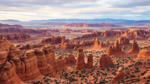
Utah spans deserts, mountains, and canyons across nearly 85,000 square miles. From red rock landscapes to alpine peaks, discover why Utah feels far bigger than it looks on the map.
Utah spans deserts, mountains, and canyons across nearly 85,000 square miles. From red rock landscapes to alpine peaks, discover why Utah feels far bigger than it looks on the map.

Vineyards can be as small as a single acre or stretch for thousands across rolling landscapes. Discover how vineyard size influences wine quality, production, and the stories behind every bottle.

Alaska spans over 663,000 square miles—larger than Texas, California, and Montana combined. From towering mountains and endless tundra to glaciers, coastlines, and wild skies, Alaska redefines what “big” truly means. This is a place where distance, wilderness, and scale stretch far beyond the map.
Arches National Park spans just 119 square miles, yet holds over 2,000 natural stone arches, vast desert views, and geological wonders shaped over millions of years. From iconic red rock formations to endless skies, this Utah park proves that size isn’t measured only in miles—but in awe.
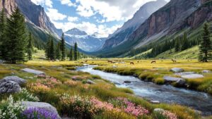
Rocky Mountain National Park spans 415 square miles, but its true size is felt in soaring peaks, deep valleys, and vast alpine tundra. From the Continental Divide to glacier-carved basins, this Colorado icon packs immense vertical scale and ecological diversity into a landscape that feels endless once you step inside.
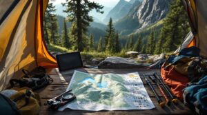
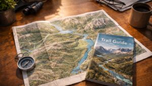
A backcountry topo map is your guide where roads vanish and terrain rules. Learn how contour lines reveal elevation, routes, and hidden hazards—and why these maps remain essential for wilderness navigation and exploration.

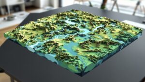
A contour model transforms flat elevation data into a living 3D landscape. Discover how these layered models reveal hills, valleys, and terrain logic, and why they’re essential in architecture, planning, education, and environmental design.

A property map is more than lines on paper—it’s a visual guide to land ownership, boundaries, and hidden rules that shape how property is used. Discover how property maps work, why they matter, and how they influence real estate, planning, and everyday decisions.

A cartographic map is more than a picture of land. It is a carefully designed blend of science, art, and storytelling that turns geography into meaning. Discover how cartographic maps shape navigation, education, history, and how we understand the world around us.

A nautical chart is far more than a map of the sea. It reveals hidden depths, underwater hazards, tides, and navigation routes that keep vessels safe. Explore how nautical charts work, why they matter, and how they’ve guided sailors for centuries across the world’s most unpredictable waters.
A wetland map reveals where land and water meet, shaping ecosystems, development decisions, and conservation efforts. Discover how wetland maps are created, why they matter, and how they influence everything from homebuilding to climate resilience in this deep dive into one of nature’s most powerful planning tools.
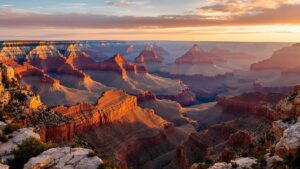
How big is the Grand Canyon? Stretching 277 miles long, over a mile deep, and nearly 18 miles wide, this natural wonder defies simple measurement. Explore its vast scale, ancient history, and why no photo or statistic fully captures its breathtaking immensity.
How big is a ranch? From small lifestyle properties to massive landholdings spanning thousands of acres, ranch size varies widely. This guide explores how climate, geography, livestock needs, and history determine just how big a ranch really is—and why bigger doesn’t always mean better.

How big is a subdivision? The answer ranges from tiny urban clusters to massive master-planned communities spanning thousands of acres. This guide breaks down subdivision size, density, zoning, and design to reveal what really defines a neighborhood—and why size alone doesn’t tell the whole story.

A star map poster turns a meaningful moment into a snapshot of the universe. Using real astronomical data, it captures the exact night sky from a specific place and time, creating a deeply personal piece of art rooted in science, memory, and wonder.
A national park map is more than navigation—it’s a guide to adventure, safety, and conservation. Learn how these maps shape exploration, protect landscapes, and help visitors experience parks in deeper, more meaningful ways.