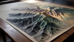
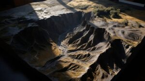
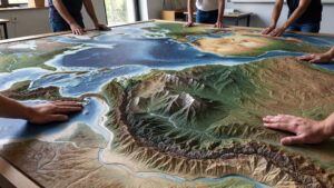
Tag: Maps

How Big Is The Mojave Desert?

How Big Is The Milky Way?

The Milky Way stretches over 100,000 light-years and contains hundreds of billions of stars. Explore the true size of our galaxy, from its spiral arms to its dark matter halo, and discover what its vast scale means for our place in the universe.

Read More »
How Big Is The Mojave Desert

How Big Is The Mojave Desert?

The Mojave Desert spans 47,000 square miles across four states, but its true size goes far beyond numbers. From Death Valley’s depths to Joshua tree forests and the bright lights of Las Vegas, discover how vast, dramatic, and unforgettable this iconic American desert really is.

Read More »
How Big Is a Golf Course

How Big Is a Golf Course?

How big is a golf course, really? From compact 9-hole layouts to sprawling 200-acre championship venues, discover the true scale behind the fairways. This in-depth guide explores acreage, yardage, design, and land use—revealing just how massive golf courses are and why their size matters more than you think.

Read More »
What Is a Children's Atlas

What Is a Children’s Atlas?

A children’s atlas is more than a book of maps—it’s a gateway to adventure. With colorful illustrations, simple geography, and global stories, it invites young readers to explore the world from their own home. Each page sparks curiosity, builds understanding, and helps children see how big, diverse, and connected our planet truly is.

Read More »
What Is a World Relief Map

What Is a World Relief Map?

A world relief map transforms Earth from flat paper into a living landscape. With raised mountains, deep oceans, and sculpted continents, it reveals how our planet truly looks and feels—turning geography into an experience you can see, touch, and explore.

Read More »
What Is a Hunting Map

What Is a Hunting Map?

A hunting map is more than lines and colors—it’s a secret language of the land. It reveals where animals travel, where you can hunt legally, and how to move with confidence. From ridgelines to hidden valleys, a hunting map transforms wilderness into strategy, guiding every step of your journey before you ever set foot in the field.

Read More »
How Big is Nevada

How Big is Nevada?

Nevada is far more than neon lights and desert highways—it’s one of the largest, most geographically diverse states in America. From alpine peaks and ghost towns to glowing cities and secret lakes, Nevada stretches across vast distances that surprise even seasoned travelers. Discover just how big Nevada really is, how it compares to other places, and why its scale shapes everything within it.

Read More »
How Big Is a City Block

How Big Is a City Block?

A city block seems simple—until you try to measure it. Some are short, some stretch endlessly, and each one shapes how a city feels. In this guide, discover how city blocks vary around the world, why planners designed them that way, and how they influence walking, business, and everyday life in ways you’ve never noticed before.

Read More »
How Big is Everglades National Park

How Big is Everglades National Park?

The Gulf of Mexico is far larger than most people realize. Spanning hundreds of thousands of square miles, it shapes weather, ecosystems, economies, and history across North America. Discover just how massive this powerful body of water truly is—and why its size matters more than you think.

Read More »
Contour

What Is a Contour Map?

A contour map uses flowing lines to reveal the hidden shape of the land. Each line marks equal elevation, showing how terrain rises, falls, and flows. Learn how contour maps work, how to read them, and why they remain essential tools for navigation, science, and understanding the Earth’s surface.

Read More »
What Is a Terrain Model

What Is a Terrain Model?

A terrain model turns the Earth’s surface into a three-dimensional landscape you can see and understand instantly. From mountains and valleys to rivers and coastlines, these models reveal how land is shaped and why it matters. Discover how terrain models are made, used, and why they remain essential tools for learning and planning.

Read More »
What Is a Raised Relief Map

What Is a Raised Relief Map?

A raised relief map turns flat geography into a three-dimensional landscape you can see and feel. From towering mountains to winding valleys, these maps bring Earth’s surface to life. Discover how raised relief maps work, how they’re made, and why they remain one of the most powerful ways to understand our planet.

Read More »
How Big Is The Gulf of Mexico

How Big Is The Gulf of Mexico?

The Gulf of Mexico is far larger than most people realize. Spanning hundreds of thousands of square miles, it shapes weather, ecosystems, economies, and history across North America. Discover just how massive this powerful body of water truly is—and why its size matters more than you think.

Read More »
How Big Is Utah

How Big Is Utah?

Utah spans deserts, mountains, and canyons across nearly 85,000 square miles. From red rock landscapes to alpine peaks, discover why Utah feels far bigger than it looks on the map.

Read More »

Get a Free Quote on a Custom 3D Billboard

Get a Free Quote