
Chesapeake Bay Watershed Maps
The Chesapeake Bay, frequently recognized as the crown jewel of American estuaries, stands out not merely due to its geographical vastness. It embodies a teeming, lively ecosystem, plays a pivotal role in the economic vitality of the region, and resonates deeply with the cultural and historical narratives of the nation. Spanning an extensive watershed that stretches across multiple state boundaries, the Chesapeake is a testament to nature’s grandeur and resilience. As we dive into the Chesapeake Bay’s watershed maps, we’ll uncover the layers of its history, the intricacies of its flow patterns, the challenges threatening its very essence, and the relentless conservation efforts to safeguard its future.
Demystifying the Watershed Concept
At the heart of understanding any significant water body is the concept of its watershed. Essentially, a watershed is a distinct land expanse where all forms of water, from raindrops dancing on rooftops to melting snow blankets, converge and flow towards a singular destination, which could be a river, a serene lake, or, in the context of the Chesapeake, a majestic estuary. Picture it as a grand amphitheater where every water molecule plays its part, each directed by the land’s contours, ensuring that every drop that falls within this realm is directed and channeled into the depths of the Chesapeake Bay.
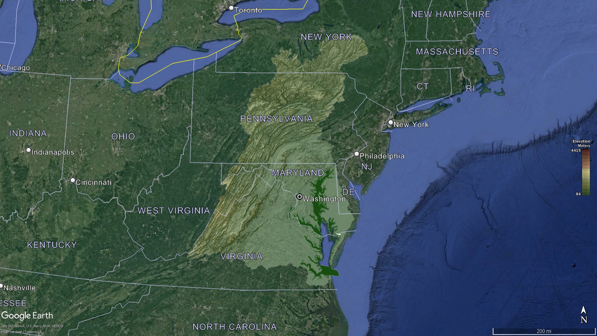
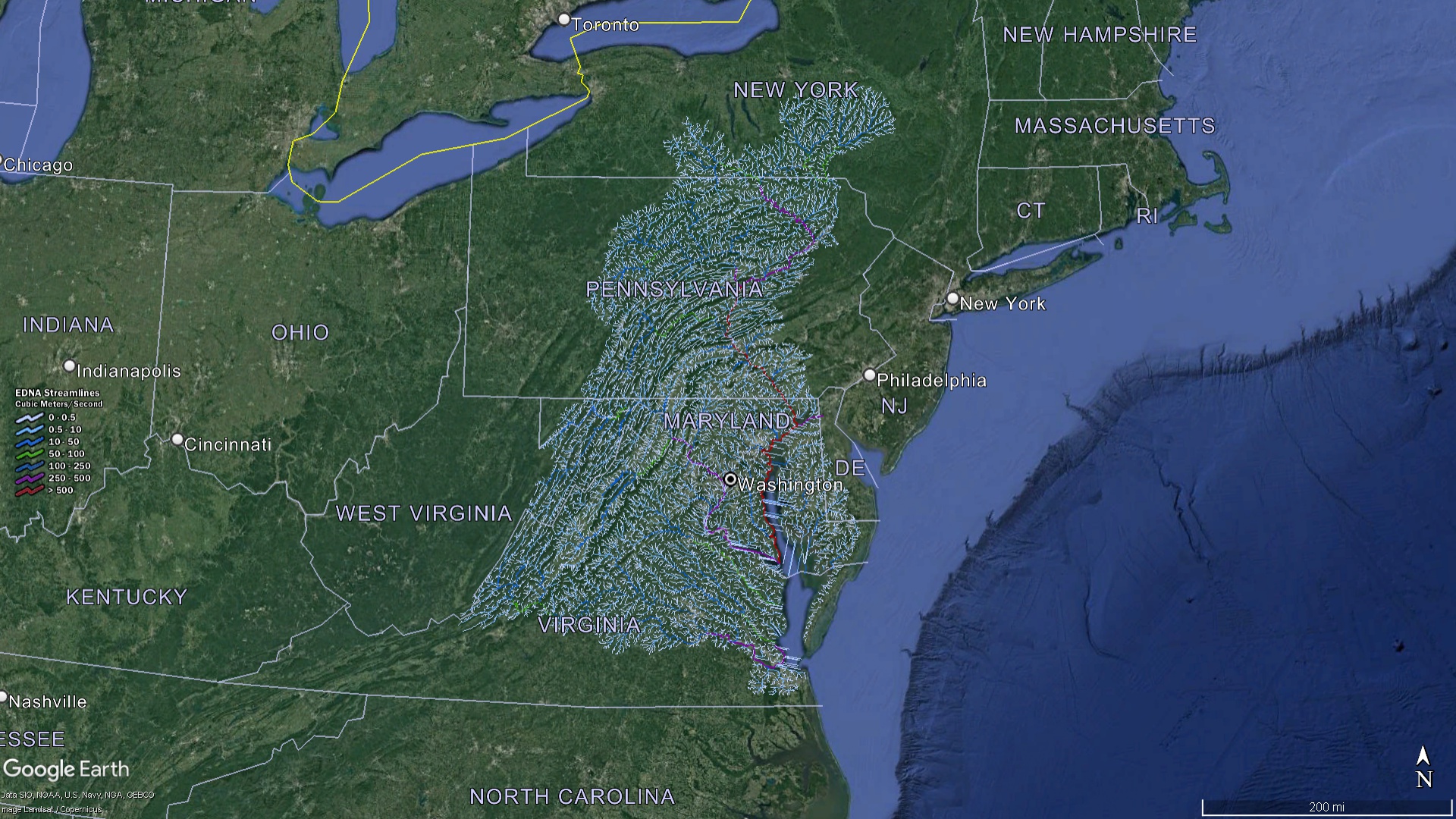 Chesapeake Bay Watershed with Streams
The Sprawling Domain of the Chesapeake Bay Watershed
When we lay our eyes on the Chesapeake Bay Watershed map, what unfolds is an awe-inspiring expanse that reaches out and touches parts of six distinct states: New York, Pennsylvania, Delaware, Maryland, Virginia, and West Virginia. Additionally, it envelopes the entirety of the District of Columbia. Covering an impressive area of approximately 64,000 square miles, this watershed is the lifeline for over 18 million inhabitants and serves as a haven for a diverse array of flora and fauna, many of which are unique to the region.
The Major Arteries: Rivers Breathing Life into the Bay
While all paths in this watershed lead to the magnificent Chesapeake Bay, the journey of its waters is initiated in distant lands, coursing through numerous rivulets, streams, and mighty rivers before converging into the bay:
Susquehanna River
Holding the title as the principal contributor of the bay’s freshwater influx, the Susquehanna River stands tall as the most voluminous tributary feeding the bay. Its origins trace back to the scenic landscapes of upstate New York.
Potomac River
This historic river, meandering gracefully through the heart of Washington D.C., is indispensable, providing a fresh, rejuvenating flow to the bay’s southern expanses.
James, York, and Rappahannock Rivers
These rivers, with their headwaters nestled among Virginia’s picturesque terrains, are integral to the Chesapeake’s intricate hydrological network, each playing its part in nourishing and sustaining the bay’s waters.
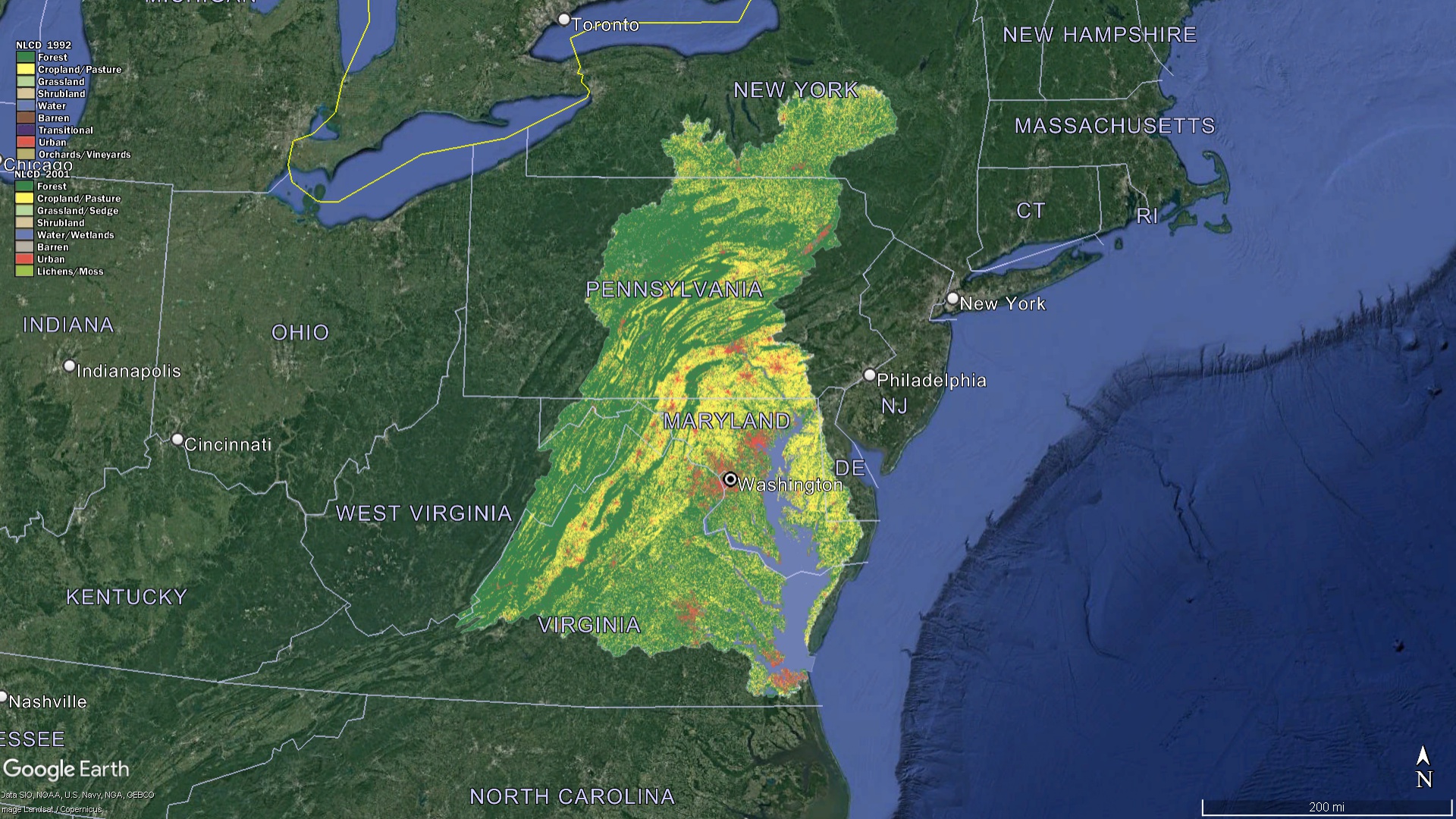 Chesapeake Bay Watershed Land Characteristics
Chesapeake’s Significance and Abundant Offerings
The Chesapeake Bay, with its expansive shimmering waters, isn’t merely a vast body of water that graces the East Coast. It represents a pulsating, life-sustaining force that has shaped both nature and civilizations for centuries.
-
Ecological Marvel: At its core, the Chesapeake Bay stands out as an ecological treasure trove. It’s a haven for the iconic blue crabs, which have become synonymous with the bay and have garnered fame nationwide. But the richness doesn’t end there. The bay provides nurturing habitats for a plethora of migratory birds, making it a paradise for ornithologists and bird watchers. Its waters and adjoining wetlands house diverse fish species, mollusks, and other aquatic life forms. Each species, whether big or small, plays a distinct role in maintaining the ecological balance, making the bay a veritable hotspot of biodiversity.
-
Economic Hub: Beyond its ecological importance, the bay serves as a massive economic engine for the region. Fishing, especially the harvest of oysters, crabs, and clams, has been a traditional activity, sustaining countless families for generations. These seafood delights, sourced from the bay, grace tables across the country and are a testament to the bay’s bountiful produce. Moreover, the allure of its serene waters and picturesque landscapes draws millions of tourists every year, bolstering the hospitality and tourism sectors. Furthermore, its strategic location has fostered shipping and trade activities, with harbors and ports dotting its expanse, facilitating commerce and contributing billions to the region’s economy.
-
A Tapestry of Cultural and Historical Heritage: The waters and shores of the Chesapeake Bay have witnessed a tapestry of stories that have woven the fabric of American history. Long before the European settlers set foot, indigenous tribes revered the bay, with its waters and lands playing a central role in their daily life, rituals, and folklore. The bay’s significance continued as European settlers arrived, becoming a pivotal site for trade, exploration, and even conflicts. Over the centuries, it has been the backdrop for monumental historical events and has inspired countless tales, songs, and artworks. Its rich legacy transcends time, linking past civilizations with present communities and serving as a reminder of the intricate bond between humans and nature.
 Chesapeake Bay Watershed Elevation
The Formidable Challenges Shadowing the Chesapeake Watershed
The immense significance and role of the Chesapeake watershed underscore the paramount responsibility resting on our shoulders. Yet, this vital watershed confronts a myriad of intricate challenges that demand immediate and comprehensive attention:
-
Pollution: The vast expanse of the Chesapeake watershed is peppered with bustling urban hubs, sprawling farmlands, and numerous industries. This diverse land use results in a significant pollution burden. Particularly concerning is nutrient pollution, primarily arising from excessive nitrogen and phosphorus runoffs. These nutrients, when introduced into the bay’s waters, can lead to a cascade of ecological problems, including harmful algal blooms that deprive the water of essential oxygen, harming aquatic life.
-
Land Development and Alterations: The relentless march of urbanization and development has left its mark on the watershed. The urban sprawl, coupled with rampant deforestation for infrastructural growth, disrupts the natural flow of water. This not only alters the water’s pathways but exacerbates the risk of sediment buildup and the introduction of various pollutants into the bay’s delicate ecosystem.
-
Climate Change and Its Repercussions: The global specter of climate change looms large over the Chesapeake watershed. This manifests in rising sea levels, which threaten coastal habitats. Additionally, escalating temperatures can exacerbate problems like evaporation and potentially harm species accustomed to specific temperature ranges. The unpredictable shifts in precipitation patterns further compound these challenges, introducing uncertainties in water flow and availability, thus unsettling the estuary’s delicate ecological balance.
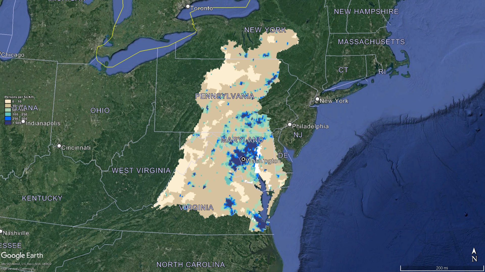 Chesapeake Bay Watershed Population
Paving the Path to Conservation through Mapping
The process of truly understanding and appreciating the Chesapeake’s vast watershed is deeply intertwined with the intricate maps that chart its expanse:
-
Educational Endeavors: Integrating watershed maps into educational syllabi offers students a tangible connection to the environment they inhabit. It equips the next generation with a deep-seated understanding of the Chesapeake’s monumental importance and the challenges it grapples with. This knowledge is fundamental in fostering a sense of stewardship and responsibility.
-
Research and Continuous Monitoring: The watershed maps serve as living documents, continuously evolving with advancements in research. By frequently updating and leveraging these maps, researchers and conservationists can closely monitor the bay’s health, track pollution hotspots, and observe shifts in species distribution. Such insights are invaluable in shaping conservation strategies.
-
Guided Land Use Decisions: For policymakers, the watershed maps function as crucial tools. They provide a comprehensive overview, guiding land use and development decisions, ensuring that the health and vitality of the watershed remain primary considerations.
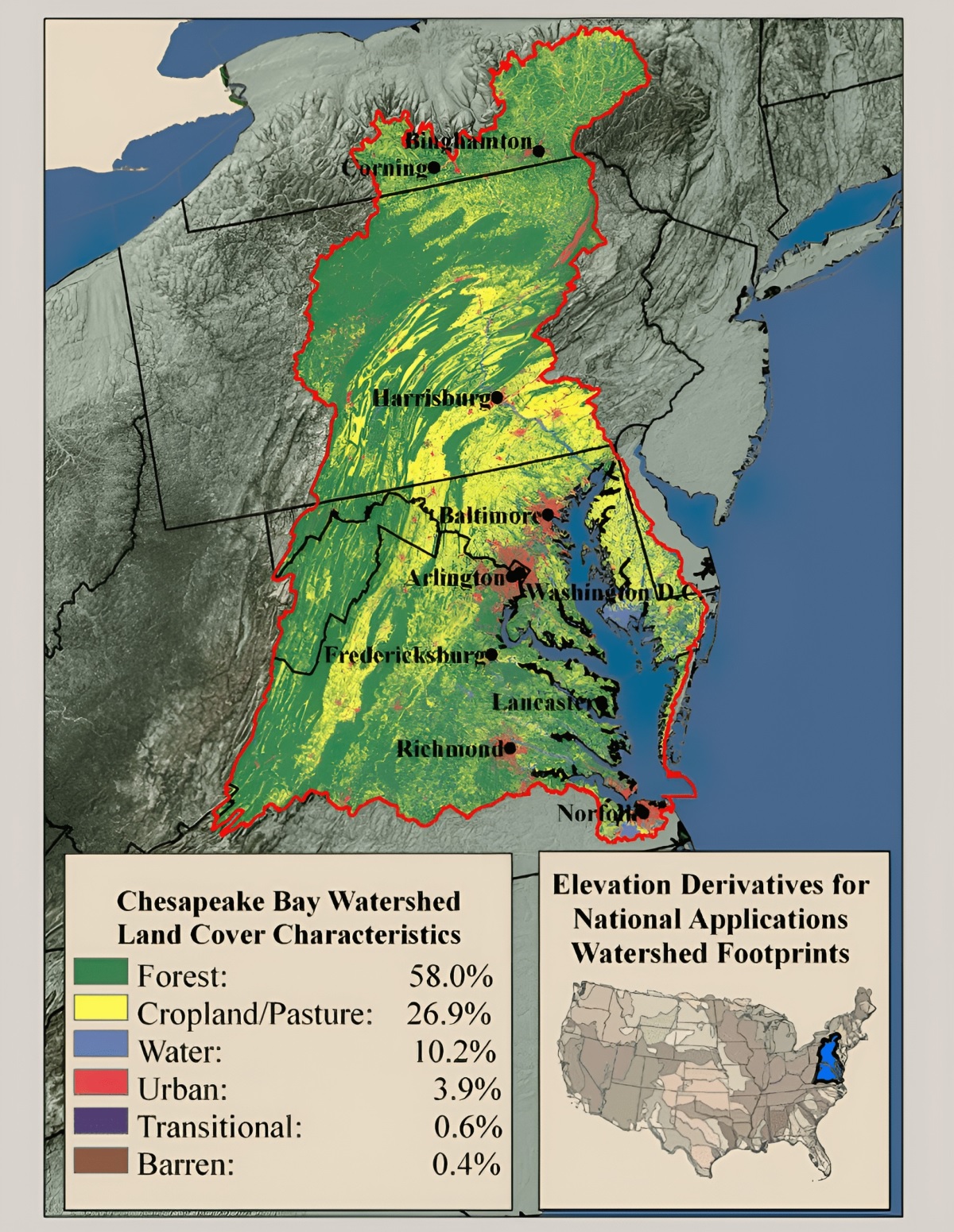 Chesapeake Bay Watershed Land Percentages
Legislative and Restorative Measures: Safeguarding the Bay’s Future
Aware of the Chesapeake Bay’s precarious state, a multitude of initiatives, significantly informed by insights gleaned from watershed maps, have been set in motion:
-
Chesapeake Bay Program: Established in 1983, this pioneering regional partnership has been at the forefront of the bay’s restoration endeavors. It brings together federal agencies, state governments, and local entities in a united effort to rehabilitate the bay’s ecosystem.
-
Proactive Legislative Measures: Legal instruments, like the revered Clean Water Act, alongside state-specific regulations and directives, serve as robust safeguards. They aim to curtail the inflow of pollutants, setting standards and limits that industries and communities must adhere to.
-
Empowered Community Driven Efforts: Grassroots movements have emerged as powerful forces championing the bay’s cause. Driven by local communities, these initiatives, bolstered by scientific data from watershed maps, have made significant strides in restoration activities, from shoreline cleanups to habitat rehabilitation projects.
Chesapeake Bay, with its sprawling watershed, is an American gem. Its health and vitality are intricately linked to millions of lives, both human and wild. The Chesapeake Bay watershed maps serve as compasses, guiding us in understanding, valuing, and ultimately preserving this irreplaceable treasure. As we navigate the challenges of the 21st century, these maps remind us of the delicate balance of nature and our role in safeguarding it for generations to come.
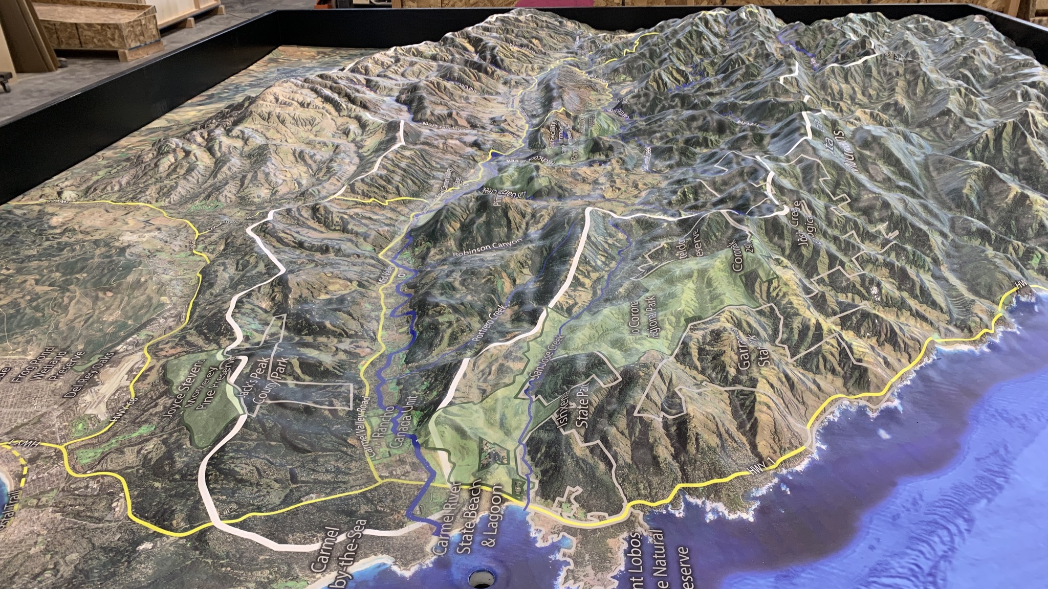
Check out our Watershed Maps for more information on Chesapeake Bay Watershed Maps. You can also learn more at our 3D Maps Learning Center.
Contact us today to learn more about our 3D services and how we can help you achieve your goals.