
Mississippi Watershed Maps
The Mississippi River, often referred to as the “Father of Waters,” is not just one of the world’s major river systems, but also a defining feature of North America. Stretching its arms across 31 states and two Canadian provinces, the river’s watershed is the largest drainage system on the continent. To truly understand its depth, breadth, and significance, one must delve into the intricacies of the Mississippi watershed maps. These charts, detailed and extensive, offer a mesmerizing journey through a river system that has shaped America’s geography, history, economy, and culture.
The Vastness and Vitality of the Mississippi Watershed
Spanning a staggering area of over 1.2 million square miles, the Mississippi River Basin stands as one of the most expansive and ecologically significant watersheds not only in the United States but on the entire North American continent. This colossal basin embraces a diverse range of landscapes, climates, and habitats, stretching from the brisk northern climes of Minnesota to the humid southern bayous of Louisiana, and even reaching tendrils into Canada.
Let’s embark on a deeper exploration of its principal regions and the myriad tributaries that feed this mighty river:
Upper Mississippi
The river’s headwaters can be traced to the serene waters of Lake Itasca, nestled amidst Minnesota’s old-growth forests. From this tranquil beginning, the Upper Mississippi winds its way south, acting as a life-giving artery for countless ecosystems. As it flows, the river nourishes vast wetlands, each acting as nature’s sponge, filtering impurities and providing nesting grounds for myriad bird species. Towering bluffs stand sentinel along its course, remnants of ancient geological events, wearing their age with a stately grace. This section is a harmonious blend of aquatic and terrestrial ecosystems, each influencing and enriching the other.
Middle Mississippi
This segment of the river is characterized by its role as a meeting point, a nexus where waters from the mighty Missouri River converge with the Mississippi. It confirms the interconnectedness of nature, as waters from the vast plains merge with those from the northern forests. As it snakes its way through the heartland, the Middle Mississippi collects waters from various tributaries, most notably the Ohio River, which pours in its bounty from the eastern parts of the basin. This confluence creates a rich aquatic tapestry, nurturing diverse fish species and offering navigation routes that have historically fostered trade and connectivity.
Lower Mississippi
As the river journeys further south, it begins to showcase its true might and grandeur. The waters widen, taking on a deep, powerful flow that has carved out some of the continent’s most iconic landscapes. Ancient floodplains stretch out on either side, bearing witness to the river’s periodic ebb and flow. These fertile lands have, over centuries, supported thriving agricultural communities. As the river meanders towards its climax, it becomes a force of nature, creating sprawling deltas and marshlands before eventually surrendering its vast volume into the warm embrace of the Gulf of Mexico.
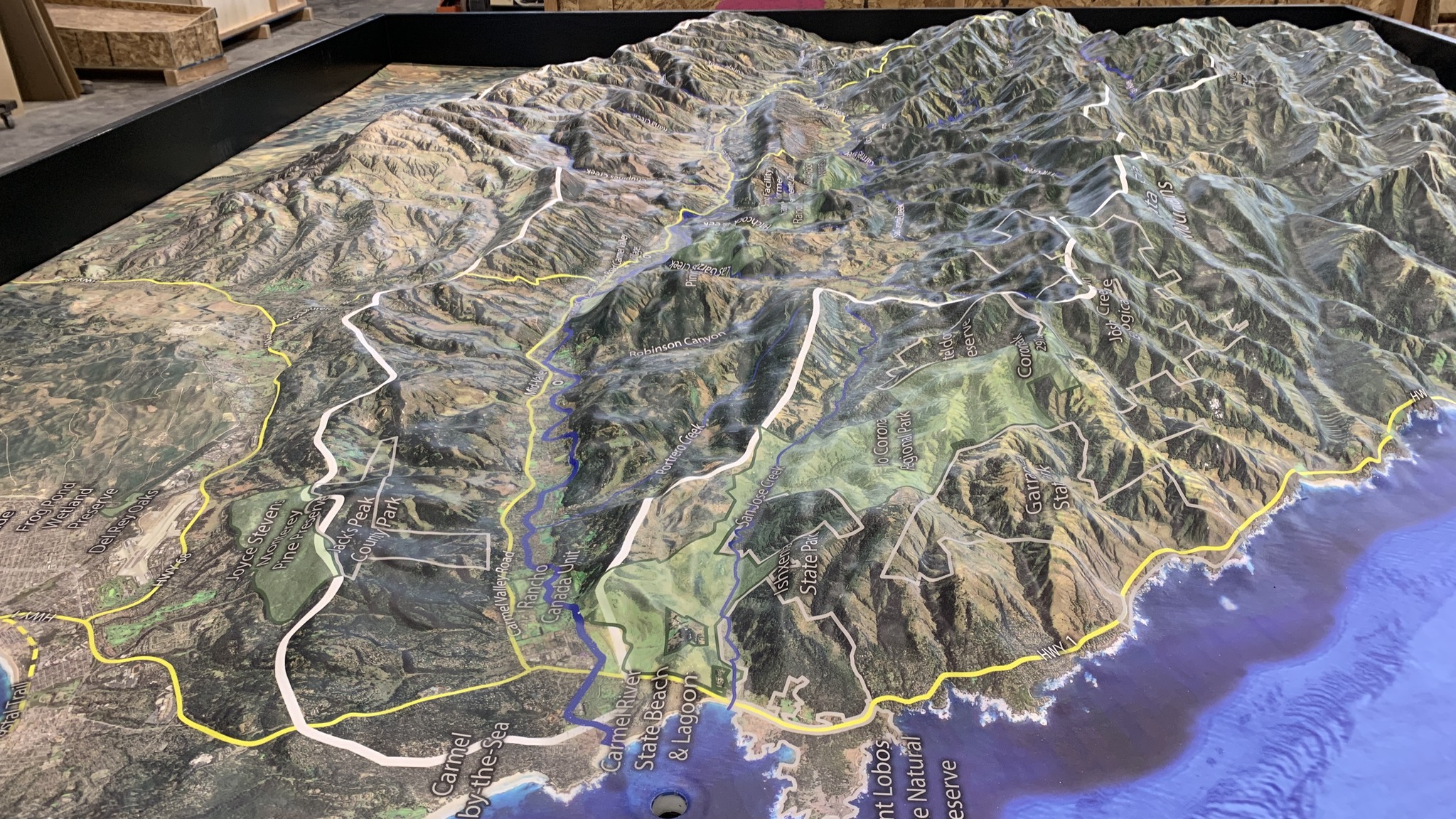
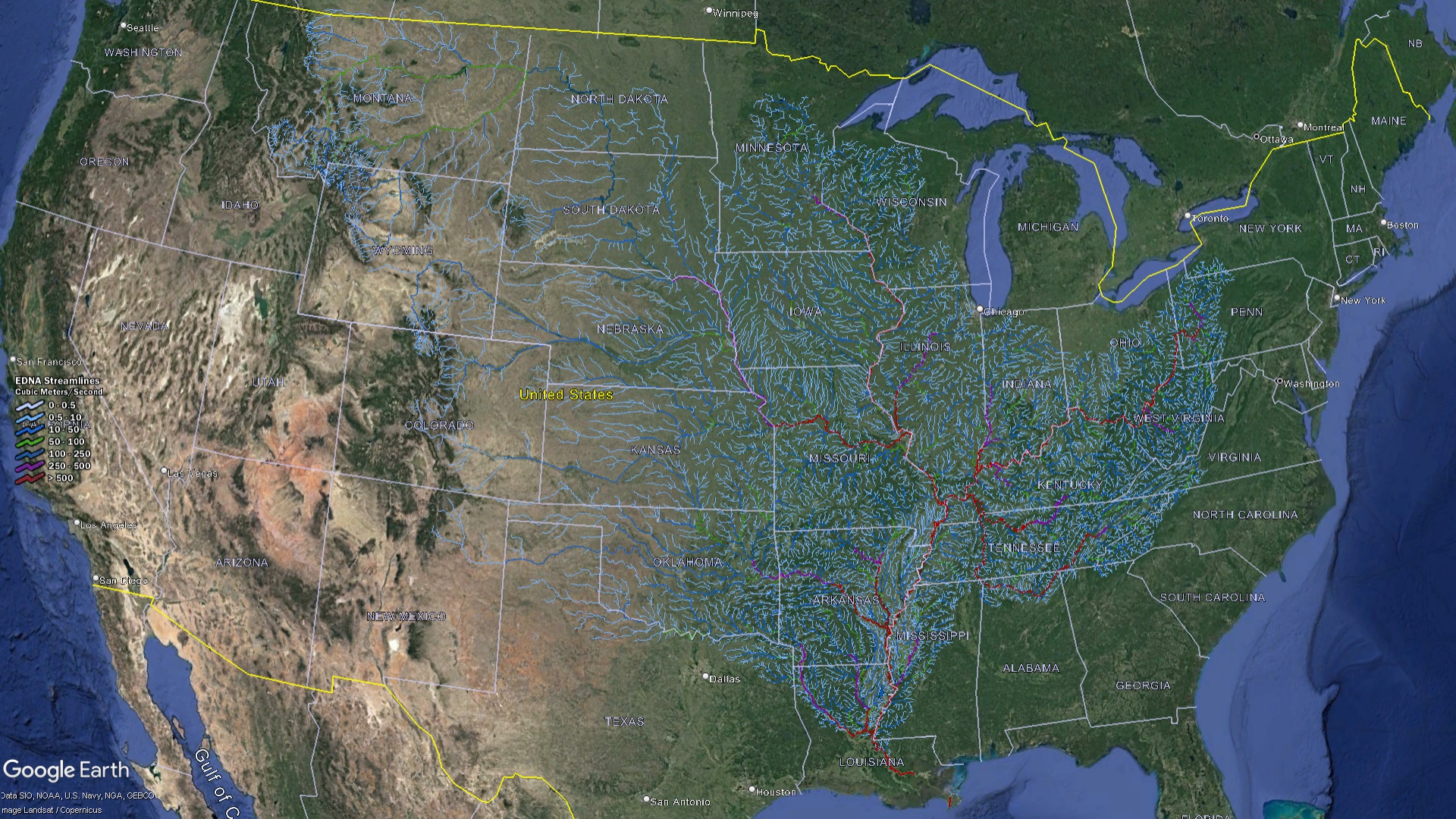 Mississippi Watershed Streams
The Mississippi Watershed: A Symphony of Life, Legacy, and Livelihood
The vast expanse of the Mississippi’s watershed is not merely an intricate network of water channels; it is a rich mosaic of life, history, and commerce that has shaped much of the American experience.
Ecological Significance: Diving deep into the ecological realm, the basin reveals itself as a sanctuary for life in all its myriad forms. The extensive wetlands, with their reeds dancing to the rhythm of the wind, serve as nature’s filtration systems and breeding grounds for countless avian species. Dense forests, where canopies create dappled sunlight patterns, are a haven for fauna, from the smallest insects to larger mammals. Sprawling prairies, painted with wildflowers, hum with the sound of insects and are frequented by grazing herds. Within this diverse ecological tapestry, several species, some teetering on the brink of extinction, find refuge and a chance at survival.
Economic Impact: Beyond its ecological richness, the river has carved out its role as the backbone of the region’s economic activities. It serves as a liquid highway, its waters bearing cargo-laden vessels, ensuring that goods and commodities reach their destinations. The fertile lands alongside the river, rejuvenated each time the waters overflow their banks, support robust agricultural activities, yielding bounties that feed nations. Fisheries dot the length of the river, their catches sustaining local economies and food chains. And then there’s tourism. With its blend of natural beauty and recreational opportunities – from fishing to river cruises – the basin attracts millions, further bolstering the local economies.
Cultural and Historical Relevance: The river’s banks whisper tales of ancient civilizations. Long before European settlers arrived, Native American tribes revered the river, its waters sustaining their communities, its course influencing their migrations and stories. As the tides of history turned, the river bore witness to explorers seeking new frontiers and played a pivotal role in the westward expansion of the young American nation. The Mississippi is not just a river; it’s a storyteller. Its influence permeates American literature, music, and folklore. Mark Twain immortalized its charm in his writings, and countless musicians have strummed and sung its praises, ensuring that the river’s tales flow beyond its banks, touching hearts worldwide.
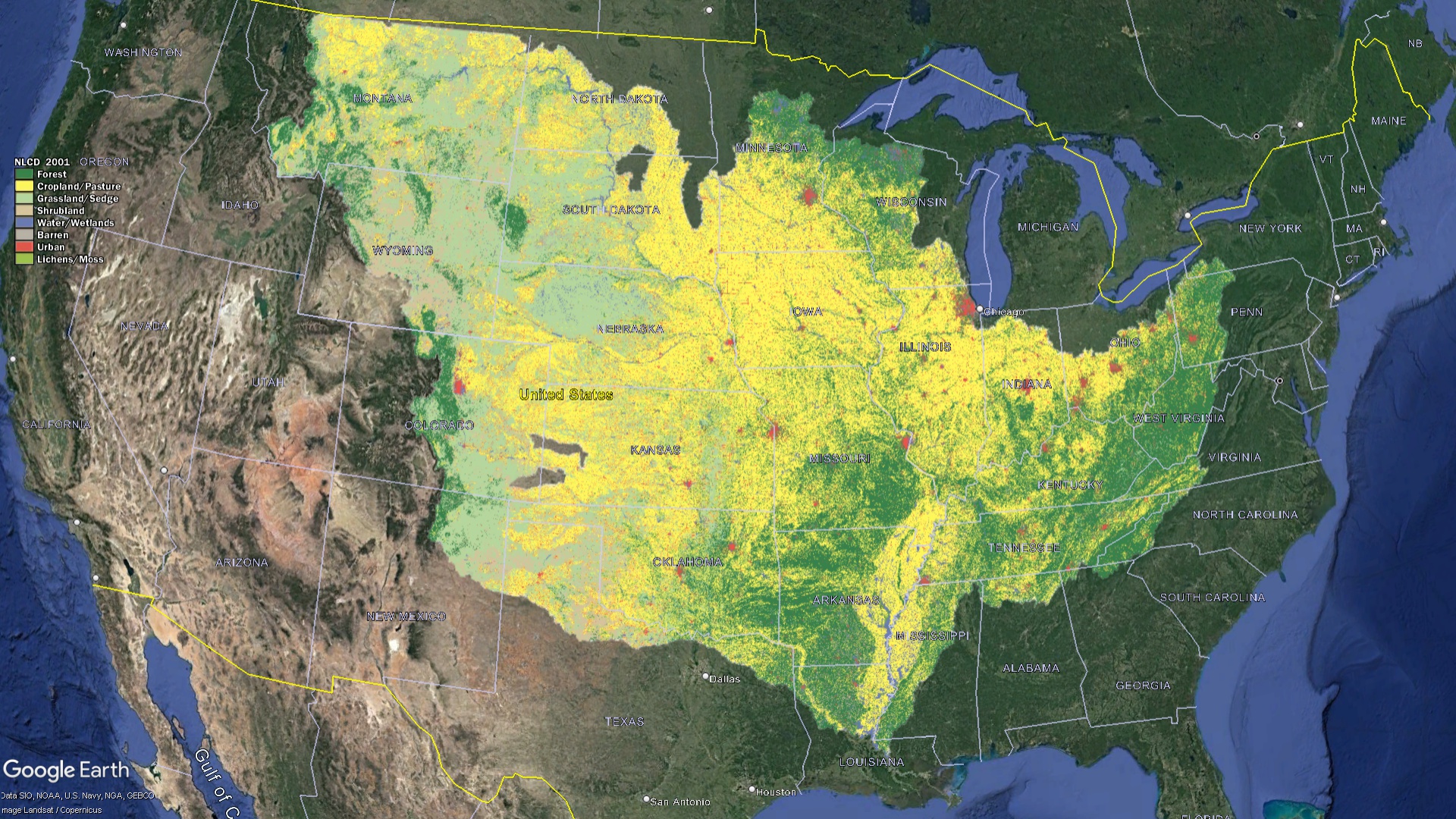 Mississippi Watershed Land Characteristics
Challenges at the Basin
For all its splendor and significance, the Mississippi watershed faces a myriad of challenges that threaten its health and, by extension, the myriad lives and activities it supports:
-
Pollution: Modern agriculture, while ensuring bountiful yields, often employs chemicals that, when washed off fields, find their way into the river. These agricultural runoffs, laden with fertilizers and pesticides, have a detrimental effect on the river’s water quality. The delicate balance of aquatic life is upset, with many species struggling to thrive amidst altered water compositions.
-
Climate Change: A global challenge that casts its shadow here too. Rising temperatures have led to changing precipitation patterns. The once predictable rhythms of the river now face uncertainties with altered water levels and flow rates. The very habitats, from wetlands to forests, are in flux, adjusting to these climatic shifts, often with consequences for the species that call them home.
-
Human Development: The march of progress, characterized by expanding urban centers and infrastructure projects, often comes at a cost to the natural environment. Urban sprawl, deforestation, and infrastructure projects can disrupt the natural flow of tributaries, exacerbating issues such as soil erosion, sedimentation, and even altering local microclimates. The challenge lies in harmonizing development with conservation, ensuring that the river continues to flow freely and healthily.
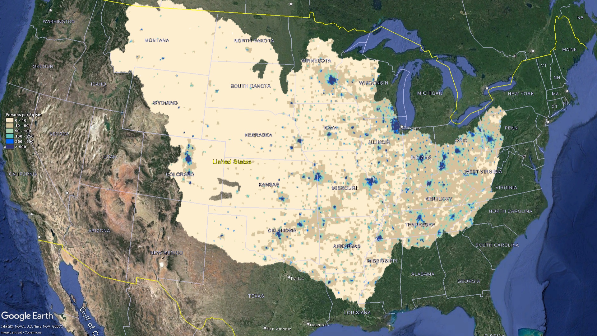 Mississippi Watershed Population
Decoding through Maps
In an era dominated by data and visualization, the Mississippi watershed maps emerge as pivotal assets, illuminating various facets of this complex hydrological network:
-
Educational Value: At the core, these maps are profound educational tools. For students, educators, and the curious public, they unfurl the intricate web of tributaries, basins, and floodplains that make up the Mississippi watershed. By charting the river’s journey, its tributaries, and surrounding terrains, these maps offer a tangible sense of the watershed’s expansive scale and critical significance. They facilitate a deeper understanding, fostering a sense of responsibility and appreciation for this natural marvel.
-
Research & Monitoring: In the world of science and research, these maps are akin to compasses, guiding explorations and observations. Scientists, hydrologists, and ecologists lean heavily on the detailed information these maps provide. They aid in tracking water flow patterns, monitoring water quality metrics, studying sediment transport, and even predicting potential ecological or hydrological shifts due to external factors like climate change.
-
Policy Crafting & Urban Planning: For decision-makers, urban planners, and conservationists, the Mississippi watershed maps serve as foundational blueprints. They detail not just the watercourses but also highlight regions of ecological significance, flood-prone areas, and regions under anthropogenic stress. With such insights, policymakers can craft informed, holistic strategies that balance development and conservation, ensuring the river’s well-being is always front and center.
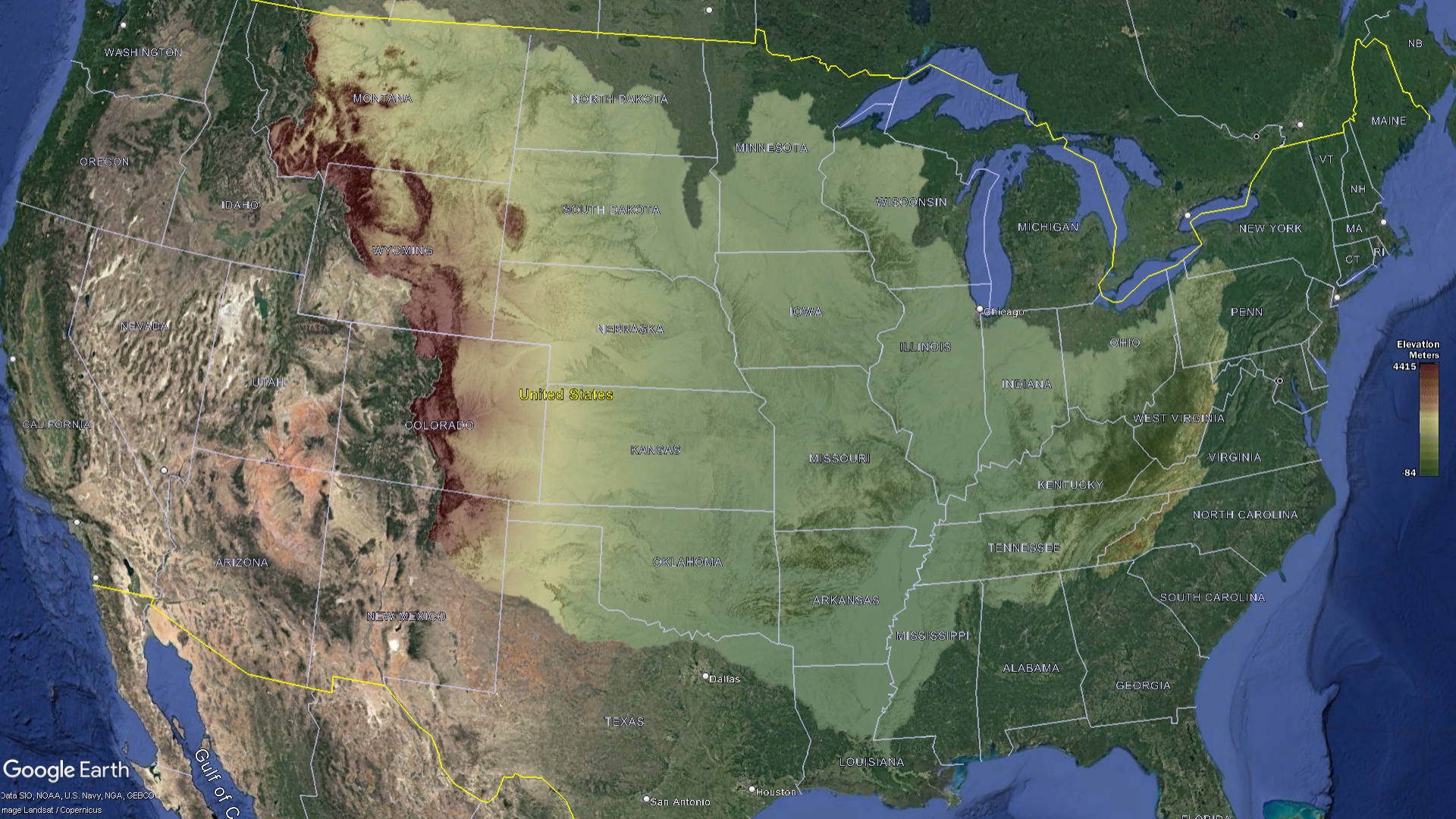 Mississippi Watershed Elevation
Conservation: A Collective Endeavor
Recognizing the unparalleled importance of the Mississippi watershed, a myriad of initiatives, both grassroots and institutional, have surged forth:
-
River Monitoring: Keeping a pulse on the river’s health is essential. State-of-the-art monitoring programs have been implemented across the basin. These initiatives employ both technology and human expertise, continually tracking water quality metrics, from chemical compositions to temperature and pH levels. Any anomalies or deteriorations are promptly identified, enabling swift remedial actions.
-
Restoration Endeavors: Over the years, sections of the watershed have faced degradation from various factors, from pollution to infrastructure developments. Addressing these, restoration projects have sprung up across the basin. These initiatives range from riverbank stabilization to prevent erosion, reforestation drives, creating artificial wetlands, and even comprehensive habitat restoration for specific species. Each project, irrespective of its size, is a testament to the collective commitment to heal and rejuvenate the watershed.
-
Legislative Armor: Laws act as the protective shield for the watershed. Over the decades, both federal and state-level regulations have been meticulously crafted and rigorously enforced. These laws tackle a spectrum of challenges, from pollution control and waste discharge standards to land use regulations and water allocation guidelines. The overarching goal remains steadfast: ensuring the sustained health, vitality, and resilience of the Mississippi watershed for generations to come.
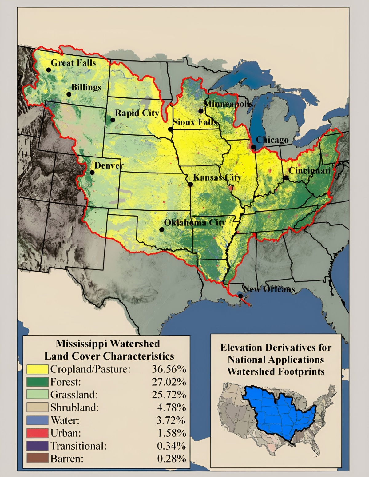 Mississippi Watershed Land Percentages
The Mississippi watershed is more than just a drainage system; it’s a living confirmation to North America’s ecological, economic, and cultural vibrancy. Understanding it through maps is akin to reading chapters of a story that unfolds over millennia. As challenges emerge, it’s up to every individual, community, and nation within the watershed to play their part in its conservation, ensuring that the Mississippi continues to flow, narrate stories, and nurture life for generations to come.
Check out our Watershed Maps for more information on Mississippi Watershed Maps. You can also learn more at our 3D Maps Learning Center.
Contact us today to learn more about our 3D services and how we can help you achieve your goals.