Arches National Park 3D Maps

We Build Custom 2D and 3D National Park Maps

Did you know we make

custom

3D raised-relief maps

park city utah ski custom 3d map

and

3D national park maps

CWD546-arches-national-park-satellite-3d-relief-map-00

Exploring Arches National Park with 3D Maps

Nestled within the captivating embrace of southeastern Utah’s red rock landscape, Arches National Park stands as a resplendent confirmation to nature’s artistic prowess.  This geological masterpiece boasts an awe-inspiring collection of over 2,000 natural stone arches, each meticulously sculpted over countless eons by the relentless caress of erosion.  A veritable magnet for adventurers, photographers, and geologists from across the globe, this park exudes an inexplicable allure.  But what if we could embark on a journey to explore this extraordinary terrain in a completely novel dimension?  Allow us to introduce you to the mesmerizing realm of 3D maps, a technology that flings open the gates to a profound understanding of Arches National Park’s geological wonders.

Arches National Park:  An Ode to Geological Marvels

To embark fully on this odyssey of 3D maps, it is imperative to first plunge into the depths of the geological marvel that is Arches National Park.  This extraordinary landscape is the offspring of an exquisite dance between geological forces and the elements.  It all commenced with the slow, deliberate deposition of sediments, a process that unfolded over geological ages.  Subsequent epochs bore witness to tremendous pressure, monumental uplift, and relentless erosion.  The fruit of these cosmic machinations?  The birth of towering sandstone formations, the creation of natural arches, and the emergence of breathtaking vistas that have etched their indelible mark upon the park’s character.

Natural Stone Arches:  Nature’s Sculptural Masterpieces

While the park itself is a canvas painted by geological forces, its defining feature remains its captivating collection of natural stone arches.  Each of these arches combine the delicate interplay between nature’s artistry and the unyielding might of geological processes.   Whether one gazes upon the delicate and slender curvature of the Landscape Arch or stands in awe before the towering grandeur of the Delicate Arch, the park’s arches manifest in a kaleidoscope of forms and sizes.  They exist as mute witnesses to the inexorable passage of time and the transformative might of natural elements.

The Dawn of 3D Mapping Technology

Now, let us transition into the intriguing realm of 3D maps, a revolutionary technology that is poised to reshape our perception of Arches National Park.  Imagine the possibility of virtually traversing this rugged terrain, where you can not only observe but also feel the texture of the sandstone beneath your very feet. Envision gazing upwards at the towering arches, the sensation of warmth from the sun on your skin, and the gentle rustling of the desert breeze – all experienced from the comfort of your own surroundings. With 3D maps, this vivid immersion becomes a reality.

CWD546-arches-national-park-satellite-3d-relief-map-03
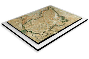
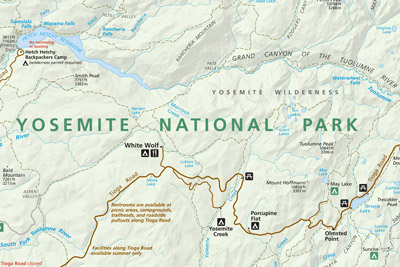
Arches National Park NPS 3D Map by WhiteClouds

A Multi-Sensory Expedition

One of the most enthralling facets of 3D maps lies in its capacity to provide a multi-sensory adventure. Employing cutting-edge technology and high-resolution imaging, 3D maps breathe life into the park’s landscapes, allowing you to virtually traverse its rugged terrain.  It feels as though you are strolling along the famed Devil’s Garden Trail, your senses awakened to the textural nuances of the sandstone, the sun’s warmth on your skin, and the harmonious symphony of desert winds.  This immersive experience bestows upon Arches National Park an unprecedented vitality.

Education Through Visualization: Unraveling Geological Mysteries

However, 3D maps offer much more than a visual spectacle; it emerges as a potent educational tool. Regardless of whether you are an avid geology enthusiast, a curious student, or simply an intrepid traveler, these maps unfold a captivating window into the geological processes that have sculpted the park.  Witness the painstaking artistry of erosion as it meticulously carved out the arches, windows, and fins over countless millennia.  This visual educational journey nurtures a deeper understanding of the natural forces that have played a pivotal role in shaping Arches National Park, effectively transforming abstract geological concepts into tangible realities.

Charting the Path of Conservation and Preservation

Beyond serving as an avenue for exploration and education, 3D maps occupy a pivotal position in the realm of conservation and preservation within Arches National Park.  Park rangers and conservationists employ these maps as invaluable tools to monitor shifts in the park’s landscape, gauge the impact of visitors, and conceive strategies for safeguarding the park’s fragile areas.  They serve as the guardians of this pristine environment, enabling the delicate equilibrium between sharing this natural wonder with the public and preserving its untarnished beauty for posterity.

CWD546-arches-national-park-satellite-3d-relief-map-04
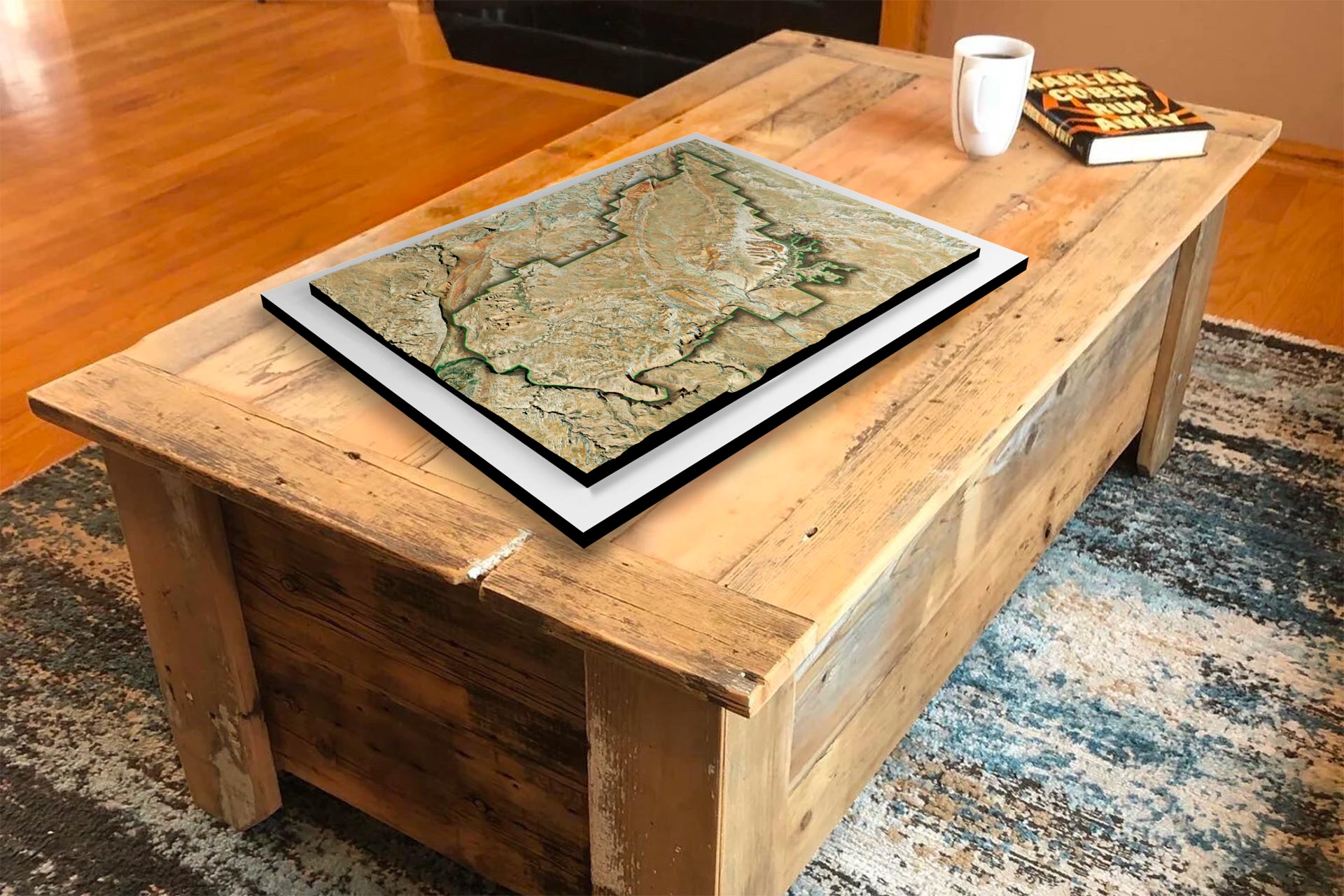
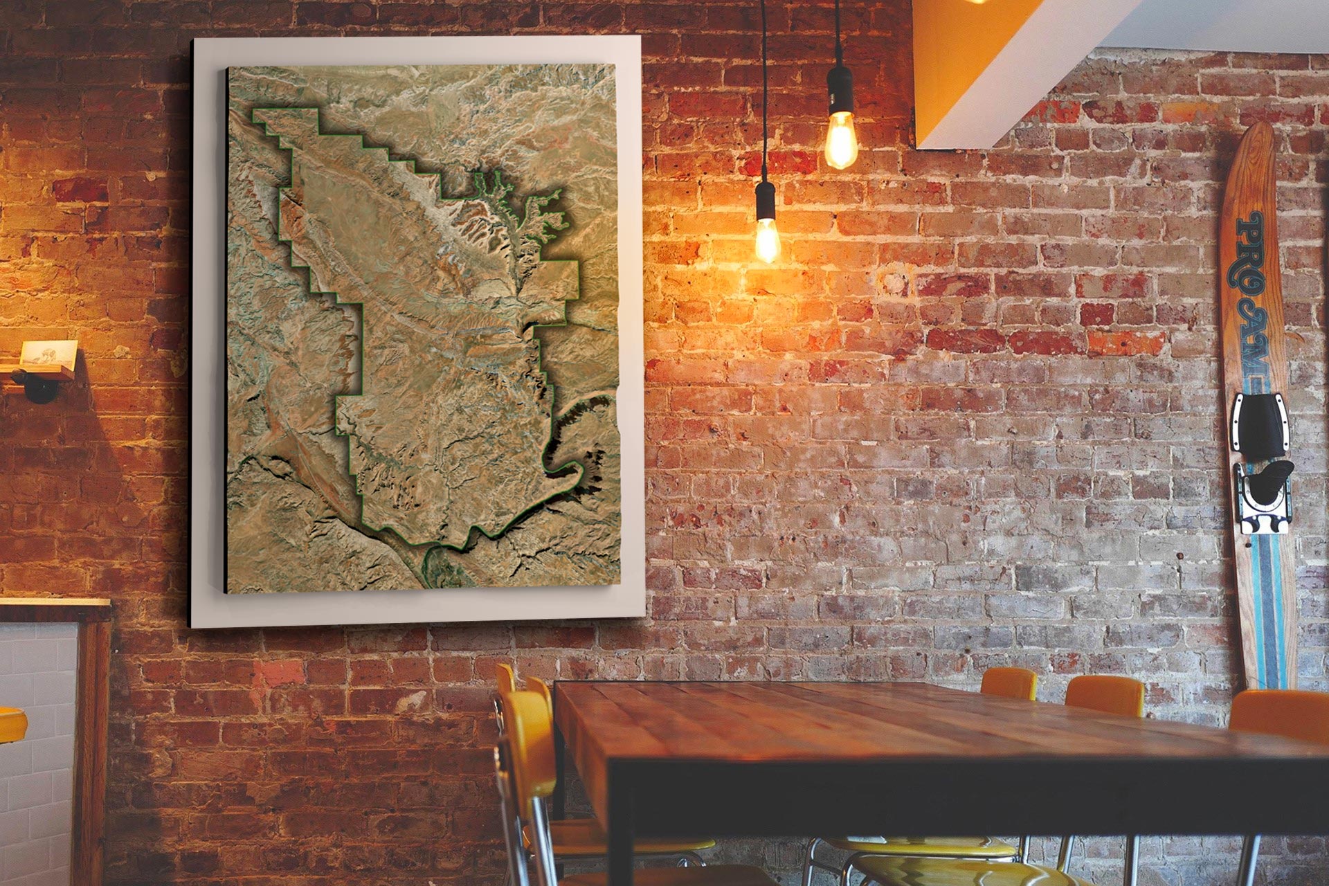
Arches National Park Satellite 3D Map by WhiteClouds

The Evolution of 3D Mapping: A New Dimension in Exploring Arches National Park

In the realm of technological advancement, we find ourselves on the brink of a new era of exploration, one that has redefined our understanding of natural marvels like Arches National Park.  Traditional cartography and photographs, while invaluable in their own right, have made way for a groundbreaking innovation – 3D mapping technology.  This revolutionary tool not only enhances navigation but also offers a profound understanding of the intricate landscapes within Arches National Park and beyond.

The Essence of 3D Mapping

At its core, 3D mapping technology represents a fusion of science and artistry.  It seamlessly integrates satellite imagery, aerial photography, and meticulous ground-level data collection to construct highly detailed, three-dimensional models of the terrain.  These physical models transcend the limitations of conventional paper maps or digital renderings, ushering in new horizons for exploration and comprehension.

Capturing the Essence of Arches National Park

Conventional topographic maps, while valuable, often struggle to convey the true spirit of a landscape.  In contrast, 3D maps breathe life into the geography they represent.  Imagine holding in your hands a tangible representation of the towering sandstone arches, the intricate canyon networks, and the rugged terrain that defines Arches National Park.  These models provide an unparalleled tactile experience, enabling you to intimately connect with the landscape even before setting foot within the park’s boundaries.

Immersive Exploration

The allure of 3D maps lies in their ability to transcend the limitations of two-dimensional representations.  They bridge the gap between the observer and the observed, transporting you into the heart of Arches’ geological wonders.  With 3D maps, you can trace the contours of Delicate Arch, almost feeling the texture of the sandstone under your fingertips. You can virtually explore the intricate passages of Fiery Furnace, gaining an immersive sense of the labyrinthine canyons.  This immersive quality is not only awe-inspiring but also invaluable for planning hikes, assessing the terrain’s challenges, and ensuring a safe and memorable adventure.

Understanding the Geological Forces at Play

Furthermore, 3D maps provide a unique opportunity to comprehend the geological forces that have shaped Arches National Park.  As you run your fingers over the models, you can visualize the eons of erosion that meticulously carved out these remarkable formations.  The tactile nature of these maps allows for a deeper connection with the natural processes that created the arches, windows, and fins scattered throughout the park.

Conservation through Tangibility

Beyond their utility as exploration aids, physical 3D maps play a vital role in conservation efforts.  Park rangers and researchers utilize these models to understand and monitor the park’s ever-changing landscapes.  The tangible nature of these maps facilitates hands-on training and the exchange of critical information among conservationists, ensuring that Arches National Park remains a pristine sanctuary for generations to come.

In essence, 3D mapping technology transcends the digital realm, offering a tangible and immersive means to connect with the geological marvel that is Arches National Park.  These physical models serve as portals to a deeper understanding of the landscape’s intricacies and the forces that have shaped it, all while nurturing a sense of wonder and stewardship for this natural treasure.

How 3D Maps Are Made: Unveiling the Magic Behind the Scenes

3D maps have revolutionized the way we navigate and explore the world around us, offering immersive and detailed representations of landscapes, cities, and natural wonders.  But have you ever wondered how these intricate 3D maps are created?  Let’s take a peek behind the curtain to uncover the magic of 3D map-making.

Data Acquisition: The Foundation of 3D Maps

At the core of any 3D map creation process is the acquisition of spatial data.  This data forms the foundation upon which the 3D map is built.  Several methods are commonly employed to gather this crucial information:

  • Aerial Imagery:  Aerial photography and remote sensing techniques, including LiDAR (Light Detection and Ranging), capture high-resolution images and elevation data from airplanes or drones.  LiDAR, in particular, provides detailed 3D point cloud data by measuring the distance between the sensor and the Earth’s surface.

  • Satellite Imagery:  Satellite-based remote sensing technologies collect vast amounts of data covering large areas.  This data includes color imagery, infrared imagery, and elevation data, allowing for a comprehensive view of the terrain.

  • Ground-Based Surveys:  Surveyors use terrestrial LiDAR scanners, GPS technology, and other instruments to collect precise data from the ground. This data is often used to complement and refine aerial or satellite data.

Data Processing: Transforming Raw Data into 3D Models

Once the raw data is collected, it undergoes extensive processing to convert it into usable 3D models.  This processing includes:

  • Data Alignment:  Merging data from various sources and ensuring that it is accurately aligned in a common coordinate system is a crucial step.  This alignment ensures that the 3D map accurately represents the real-world terrain.

  • Point Cloud Processing:  For LiDAR data, point clouds are generated, where each point represents a specific location in 3D space.  Filtering and classification algorithms are used to separate ground points from non-ground points (such as vegetation or buildings).

  • Mesh Generation:  To create a more detailed 3D representation, the point cloud is converted into a mesh.  This mesh consists of interconnected triangles that form the surface of the terrain.

  • Texture Mapping:  Aerial and satellite images are draped onto the 3D mesh to provide color and texture, making the map visually appealing and realistic.

Visualization and Interaction: Making 3D Maps User-Friendly

Creating a 3D map is not just about data; it’s about making it accessible and user-friendly. Here’s how:

  • User Interface Design:  Designing an intuitive user interface is crucial to allow users to interact with the 3D map effectively.  This includes navigation controls, search functions, and overlay options.

  • Web-Based Platforms:  Many 3D maps are accessible through web-based platforms or dedicated apps, making them available to a wide audience via computers, smartphones, and tablets.

  • Customization:  Users often have the ability to customize their 3D map experience by choosing different layers, map styles, and viewing options to suit their needs and preferences.

3D maps are a fascinating blend of data collection, processing, visualization, technology integration and a more immersive connection with the geological marvels of Arches National Park.  Whether you’re standing before a monumental sandstone monolith or preparing to traverse a narrow ridge, these maps serve as trusted companions, unveiling the intricate beauty of Arches’ terrain and facilitating unforgettable adventures within its hallowed landscapes.  They provide us with powerful tools for navigation, exploration, and understanding of our world, and they continue to evolve, offering new possibilities for both practical and recreational applications. 

CWD012-arches-national-park-the-windows-section-3d-relief-map-04 
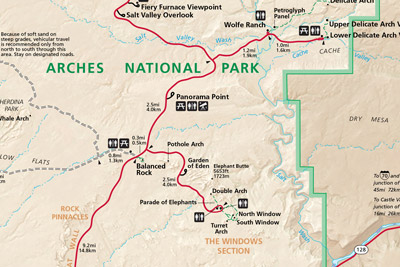
Arches National Park Satellite 3D Map – The Windows Section  

Unveiling the Park’s Hidden Treasures

Arches National Park, through the lens of 3D mapping, becomes evident that this vast and diverse landscape harbors an array of captivating areas waiting to be discovered.  The immersive power of 3D mapping technology not only brings these areas to life but also allows us to uncover the park’s most fascinating features in breathtaking detail:

  • Delicate Arch:  The Iconic Gem – No journey through Arches National Park is complete without a visit to its crown jewel – the iconic Delicate Arch.  As the park’s most renowned arch, it beckons adventurers and enthusiasts from across the globe.  With the aid of 3D mapping, you can embark on a virtual hike to this natural wonder, traversing the rugged terrain, feeling the sandstone beneath your virtual boots, and immersing yourself in its breathtaking beauty.  The intricate details of this arch, which has graced countless photographs and postcards, come alive as you virtually stand beneath its graceful span.  Every contour and curve becomes palpable, allowing you to appreciate the delicate balance that has preserved this arch over the ages.
  • Fiery Furnace:  A Labyrinth of Geological Marvels – Hidden within the heart of Arches National Park lies the enigmatic Fiery Furnace, a complex labyrinth of sandstone canyons that beckons the intrepid explorer.  Navigating this challenging terrain is now within your grasp through 3D mapping.  With precision and accuracy, these maps guide you through the twists and turns of this geological marvel, offering an immersive experience that leaves no stone unturned.  As you virtually wander through the intricate canyons, the play of light and shadow reveals the geological wonders that have shaped this unique landscape.  It’s an opportunity to marvel at the forces of nature that have meticulously crafted this hidden gem over countless millennia.
  • Devil’s Garden:  Nature’s Showcase – For those seeking to explore the park’s diverse terrain, Devil’s Garden emerges as a true showcase of nature’s artistry.  Home to the park’s longest natural arch, the Landscape Arch, this area is a testament to the enduring forces of erosion and geological upheaval. Through 3D mapping, you can embark on an immersive journey through Devil’s Garden, where the park’s intricate trail network and mesmerizing formations are brought to life in stunning detail.  As you virtually traverse the trails, each step reveals the fascinating geological history etched into the landscape.  The delicate arches, towering fins, and rugged terrain become more than just a destination; they become a living testament to the Earth’s transformative powers.
  • Balanced Rock:  Defying Gravity – Balanced Rock is a testament to nature’s delicate balancing act, where a massive sandstone boulder seems to defy gravity as it perches precariously atop a slender pedestal.  This popular attraction in the park is now yours to explore in unprecedented detail through 3D mapping.  As you virtually venture closer to Balanced Rock, you can scrutinize the surrounding landscape, gaining a deeper understanding of the geological forces at play.  Every angle, every rock formation, and every nuance of this captivating feature is unveiled, offering a profound appreciation for the intricate dance between gravity and geological processes.
  • Double Arch:  Where Two Become One – Among the myriad arches of Arches National Park, Double Arch stands as a unique formation where two massive arches share a common foundation.  Through the magic of 3D mapping, you can virtually stand beneath these towering arches and appreciate their grandeur in astonishing detail.  The intricate interplay of stone and sky is laid bare, revealing the geological history etched into the very fabric of this landscape. It’s an opportunity to immerse yourself in a natural wonder that has been shaped by the same transformative forces that have sculpted the entire park.

Conclusion

CWD010-arches-national-park-the-windows-section-3d-relief-map-00 Arches National Park USGS 1959 Historical 3D Map – The Windows section

In conclusion, Arches National Park is a treasure trove of geological marvels, and 3D mapping serves as the key to unlock its secrets.  These maps not only guide us through the rugged terrain but also offer an immersive experience that transcends physical boundaries.  Whether you’re virtually hiking to Delicate Arch, navigating the Fiery Furnace, exploring Devil’s Garden, marveling at Balanced Rock, or standing beneath Double Arch, 3D mapping unveils these areas in breathtaking detail.  It’s a journey that brings us closer to the heart of Arches National Park, fostering a deeper connection with its extraordinary wonders and the geological forces that have shaped them over countless millennia.

More National Park 3D Maps

To learn more in-depth about 3D National Parks Raised Relief Maps, view National Parks 3D Maps.    

And once you’ve chosen your next destination, why not bring the beauty of the national parks into your home or office with our National Parks Canvas Wraps?  Our canvas wraps feature stunning photographs of some of the most beautiful locations in the national parks, printed on high-quality canvas and stretched over a sturdy frame. They’re the perfect way to bring a little bit of the great outdoors into your home.

 Contact us today to learn more about our services and how we can help you achieve your goals. 

Get a Free Quote

Get a Free Quote