
North Carolina Unveiled: An Epic Journey Through the 3D Topographic Map
North Carolina, the Tar Heel State, is a land of boundless beauty, where the majestic Appalachian Mountains meet the serene coastal plains. In this comprehensive exploration, we embark on an immersive journey through the 3D topographic map of North Carolina, diving into its geographical intricacies and unraveling the captivating stories etched into its diverse terrain.
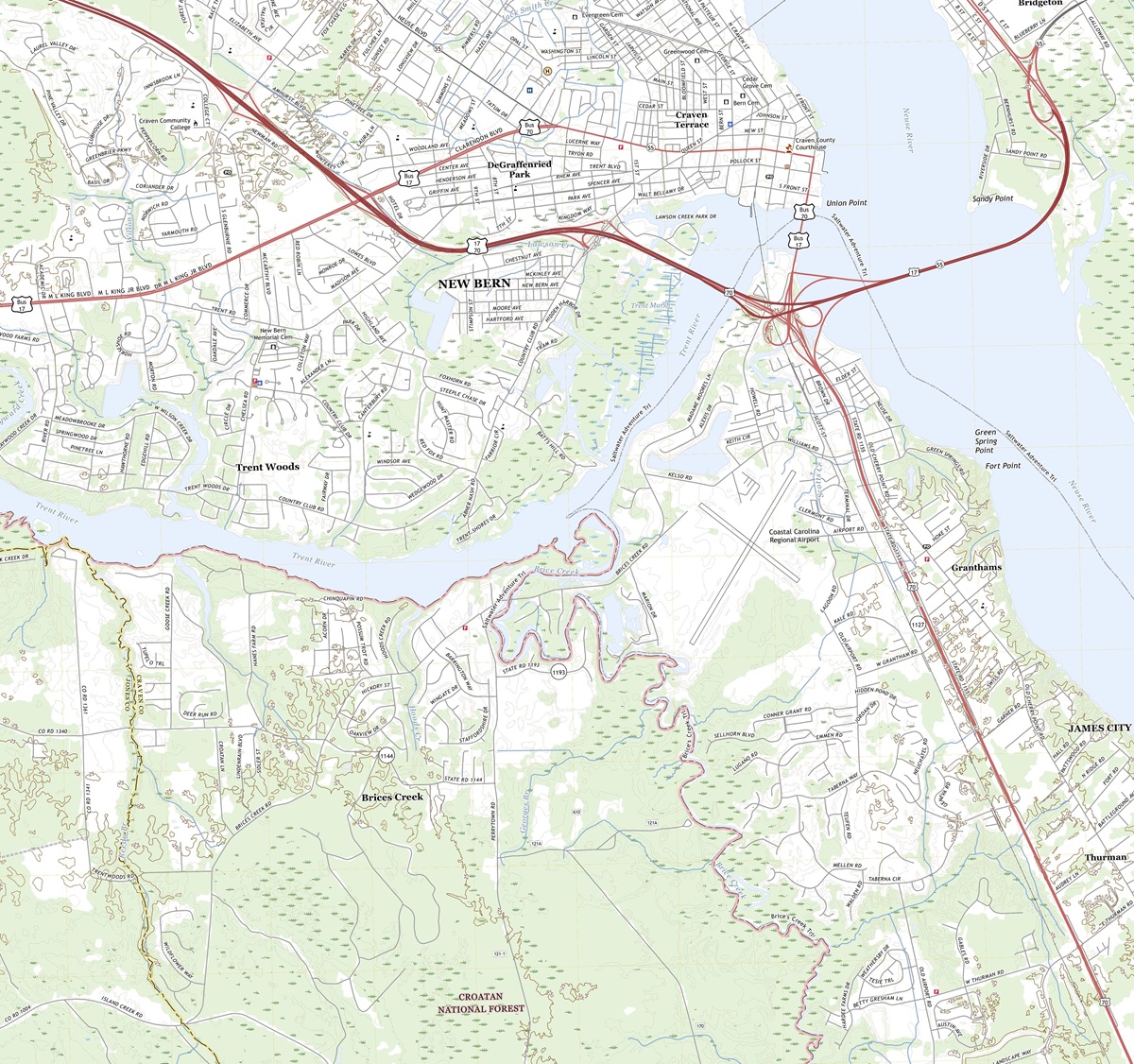 3D Topographic Map of North Carolina-New Bern, 1:24,000 quad, 2022, USGS
The World of 3D Topographic Maps
Before we embark on our journey through North Carolina’s 3D topographic map, it’s essential to understand the essence of 3D topography. These advanced maps provide a lifelike representation of the Earth’s surface, revealing elevation, terrain, and natural features in remarkable detail. Unlike traditional topographic maps, 3D maps breathe life into North Carolina’s landscapes, offering a unique perspective that allows us to explore the state’s geography in a whole new dimension.
Elevation-The Vertical Dimension
One of the most striking features of 3D topographic maps is their ability to depict elevation with astonishing accuracy. In North Carolina, where elevation varies from the towering peaks of the Appalachian Mountains to the tranquil coastlines of the Atlantic, this dimension is paramount in comprehending the state’s diverse landscapes. From the loftiest summits to the lowest valleys, 3D maps vividly illustrate the vertical aspect of North Carolina’s topography.
Terrain Visualization-A New Perspective
3D topographic maps offer an immersive experience by bringing North Carolina’s terrain to life. Every ridge, valley, and river is presented in exquisite detail, enabling us to appreciate the nuances of the state’s geography. This unique perspective allows us to uncover hidden features, understand the impact of geological forces, and grasp the interconnectedness of North Carolina’s landscapes in ways that traditional maps cannot convey.
 3D Topographic Map
The Appalachian Mountains
Rugged Peaks and Pristine Wilderness
Our journey through North Carolina’s 3D topographic map commences in the western part of the state, where the Appalachian Mountains rise in all their glory. These rugged peaks, including Mount Mitchell, the highest point in the eastern United States, offer a dramatic view of unspoiled wilderness and natural splendor.
As we explore the 3D map, the Appalachian Mountains come alive, with elevation gradients depicted in vibrant colors and intricate contours. Mount Mitchell stands tall among the peaks, inviting adventurers with its 3D prominence. This immersive experience enables us to virtually traverse these mountains and valleys, providing a glimpse of the Appalachian’s grandeur.
The Blue Ridge Parkway: A Scenic Masterpiece
The 3D topographic map vividly portrays the Blue Ridge Parkway, a scenic highway that meanders through the heart of the Appalachian Mountains. Travelers and nature enthusiasts can virtually journey along this picturesque route, immersing themselves in the terrain’s intricacies. The 3D visualization offers a unique perspective on the parkway’s winding path, revealing its dramatic curves, breathtaking overlooks, and the panoramic vistas that reward those who traverse it.
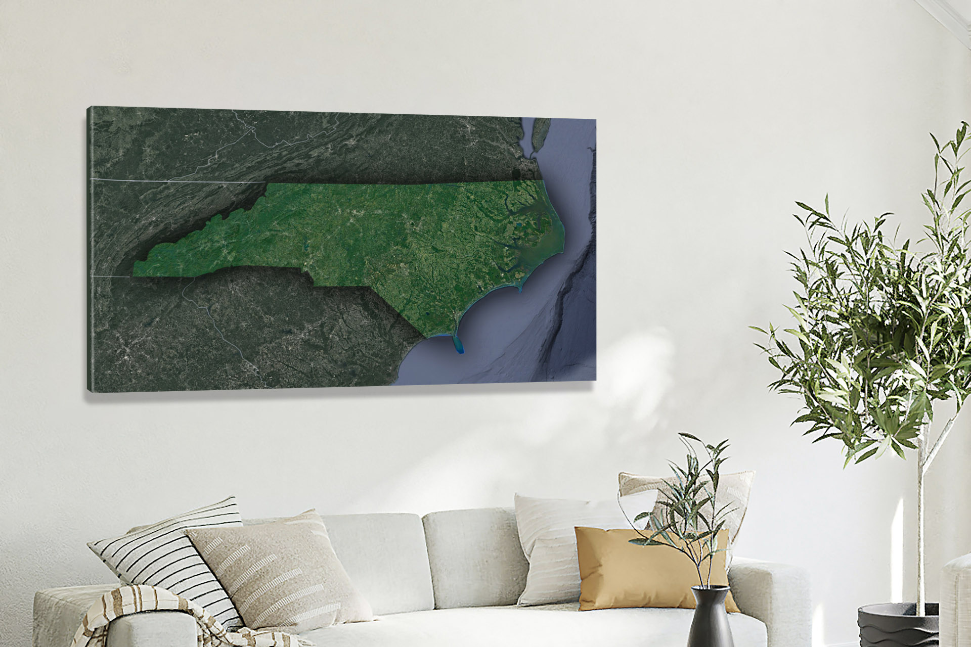
 Satellite Map of North Carolina
The Piedmont Region-Rolling Hills and Fertile Lands
Transitioning eastward across North Carolina’s 3D map, we encounter the Piedmont region, a vast expanse characterized by rolling hills, fertile plains, and a network of rivers and streams. This transitional zone plays a crucial role in shaping the state’s geography.
Elevation contours reveal the gentle slopes, river valleys, and the intricate terrain of the Piedmont region. Understanding its topography is essential for appreciating the role it plays in North Carolina’s agricultural and industrial heritage.
The Coastal Plain-Coastal Beauty and Dynamic Ecosystems
Continuing our journey, we arrive at the Coastal Plain, where North Carolina’s 3D topographic map unveils a world of coastal beauty, dynamic ecosystems, and sandy shores. Elevation gradients highlight the delicate balance between land and sea, showcasing barrier islands, estuaries, and river deltas that define this region’s topography.
The influence of the Atlantic Ocean is unmistakable, with elevation contours capturing the ever-changing interplay of tides, currents, and coastal landforms.
The Influence of Waterways-River Systems and Aquatic Wonders
North Carolina’s 3D topographic map accentuates the intricate network of rivers and streams that traverse the state. These waterways are crucial in shaping the terrain, as elevation gradients reveal their meandering courses, valleys, and the deep gorges they have carved over time. Understanding their impact on North Carolina’s topography is essential to appreciating the state’s ecological diversity and natural beauty.
The Geographical Heritage of North Carolina-A Story of Geological Diversity
Throughout our exploration, it becomes evident that North Carolina’s topography is a testament to its rich geological history. From the ancient Appalachian Mountains to the dynamic coastal plains, the 3D topographic map tells a story of millions of years of geological evolution.
Unique geological features such as Linville Gorge and the Outer Banks are intricately woven into the 3D map’s representation, offering insights into the geological forces that continue to shape North Carolina’s diverse landscape.
As we conclude our journey through North Carolina’s 3D topographic map, we depart with a profound appreciation for the state’s diverse and captivating landscapes. From the heights of the Appalachian Mountains to the tranquility of the Coastal Plain, North Carolina’s topography is a testament to its rich natural heritage.
Understanding North Carolina’s 3D topographic map isn’t just about navigation; it’s an invitation to immerse yourself in the state’s geological history, ecological diversity, and cultural significance. Whether you are an intrepid explorer, a geography enthusiast, or simply someone eager to delve into the wonders of the natural world, North Carolina’s 3D topography beckons you to embark on a journey of discovery and wonder, where the landscape springs to life in three dimensions.
Check out WhiteClouds’ 3D Topographic Maps for more information on a topographic map of North Carolina. 2D Canvas Print Satellite Maps of North Carolina are also available.
Contact us today to learn more about our 3D services and how we can help you achieve your goals.