
Idaho’s Geographic Tapestry: An Immersive Exploration of the 3D Topographic Map
Idaho, the Gem State, is a land of diverse natural wonders, where rugged mountains, pristine lakes, and fertile valleys combine to create a breathtaking mosaic of landscapes. In this comprehensive journey, we embark on an immersive exploration of the 3D topographic map of Idaho, peeling back the layers of its geographical marvels and unraveling the captivating stories etched into its terrain.
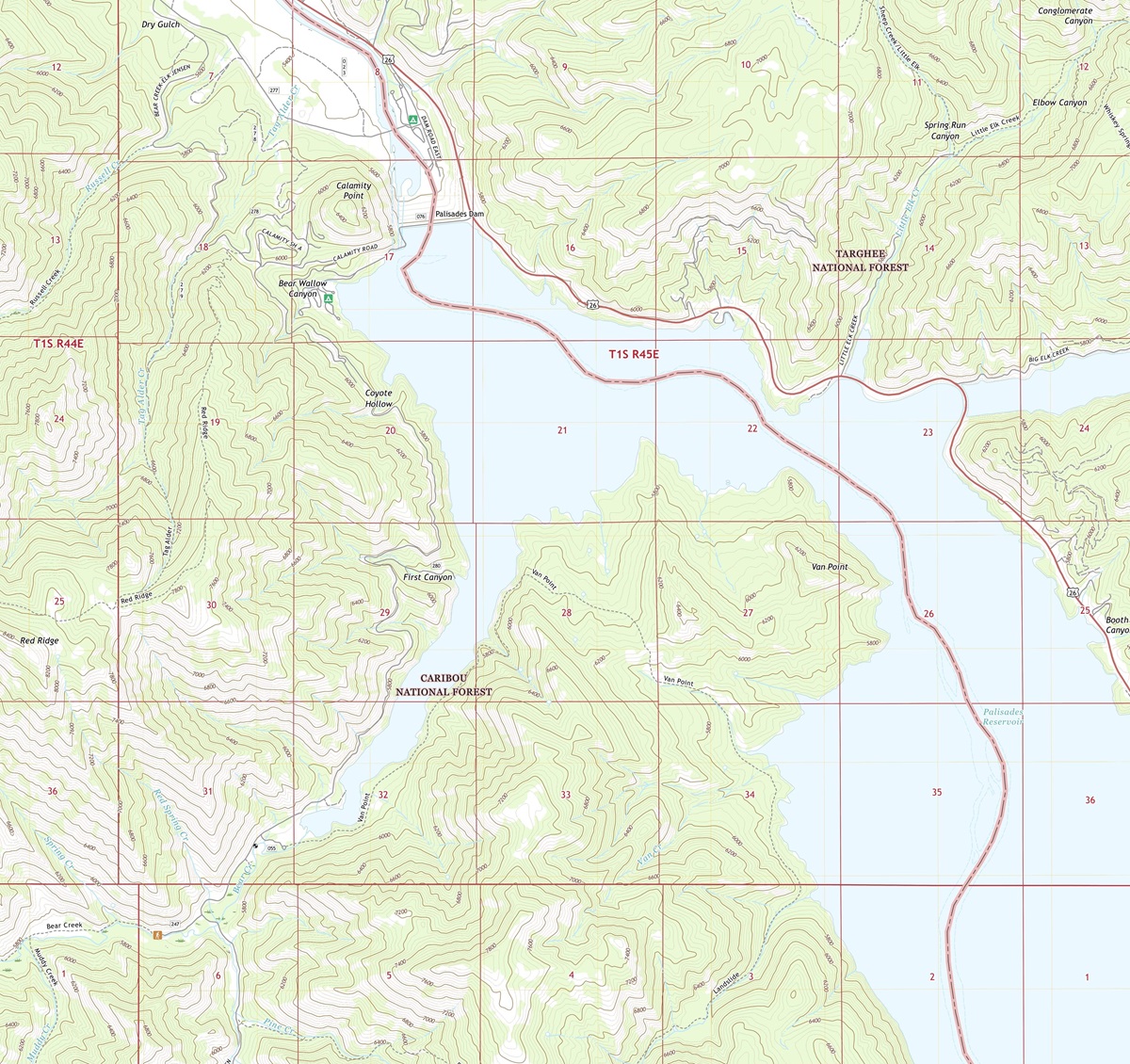 3D Topographic Map of Idaho-Palisades Dam, 1:24,000 quad, 2020, USGS
Navigating the World of 3D Topographic Maps
Before we venture into the heart of Idaho’s stunning landscapes, it’s crucial to understand the essence of 3D topographic maps. These advanced cartographic tools provide an immersive representation of the Earth’s surface, revealing elevation, terrain, and natural features with incredible precision. Unlike traditional maps, 3D maps bring Idaho’s landscapes to life, offering a unique perspective that allows us to explore the state’s geography in a whole new dimension.
Elevation: The Vertical Dimension
One of the most remarkable features of 3D topographic maps is their ability to depict elevation in stunning detail. In Idaho, where elevation varies from the depths of Hells Canyon to the towering peaks of the Sawtooth Range, this dimension is essential to understanding the state’s unique topography. From the lowest valleys to the loftiest summits, 3D maps vividly illustrate the vertical aspect of Idaho’s terrain.
Terrain Visualization: A New Perspective
3D topographic maps offer an immersive experience by bringing Idaho’s terrain to life. Every mountain range, valley, and river is presented with remarkable detail, allowing us to appreciate the intricacies of the state’s geography. This unique perspective enables us to uncover hidden features, comprehend the impact of geological forces, and understand the interconnectedness of Idaho’s landscapes in ways that traditional maps simply cannot convey.
 3D Topographic Map
The Rocky Mountains
Majestic Peaks and Wilderness Escapes
Our journey through Idaho’s 3D topographic map commences with the awe-inspiring Rocky Mountains, a region known for its majestic peaks, dense forests, and pristine lakes. This mountainous terrain is brought to life through the 3D representation, with elevation gradients showcasing the gradual rise of the Sawtooth Range and the rugged beauty of the Boulder Mountains.
As we explore the 3D map, the Rocky Mountains come to life, inviting adventurers with their pristine lakes, cascading waterfalls, and a network of trails that meander through alpine meadows. This immersive experience allows us to virtually traverse these mountains, offering a glimpse of the Rockies’ awe-inspiring majesty.
Sawtooth National Recreation Area: A Wilderness Wonderland
The 3D topographic map vividly portrays the Sawtooth National Recreation Area, where outdoor enthusiasts and nature lovers can virtually hike along pristine trails, fish in crystal-clear lakes, and bask in the serenity of the alpine wilderness. This immersive visualization offers a unique perspective on the area’s rugged terrain, serene lakes, and the breathtaking vistas that reward those who explore its natural wonders.
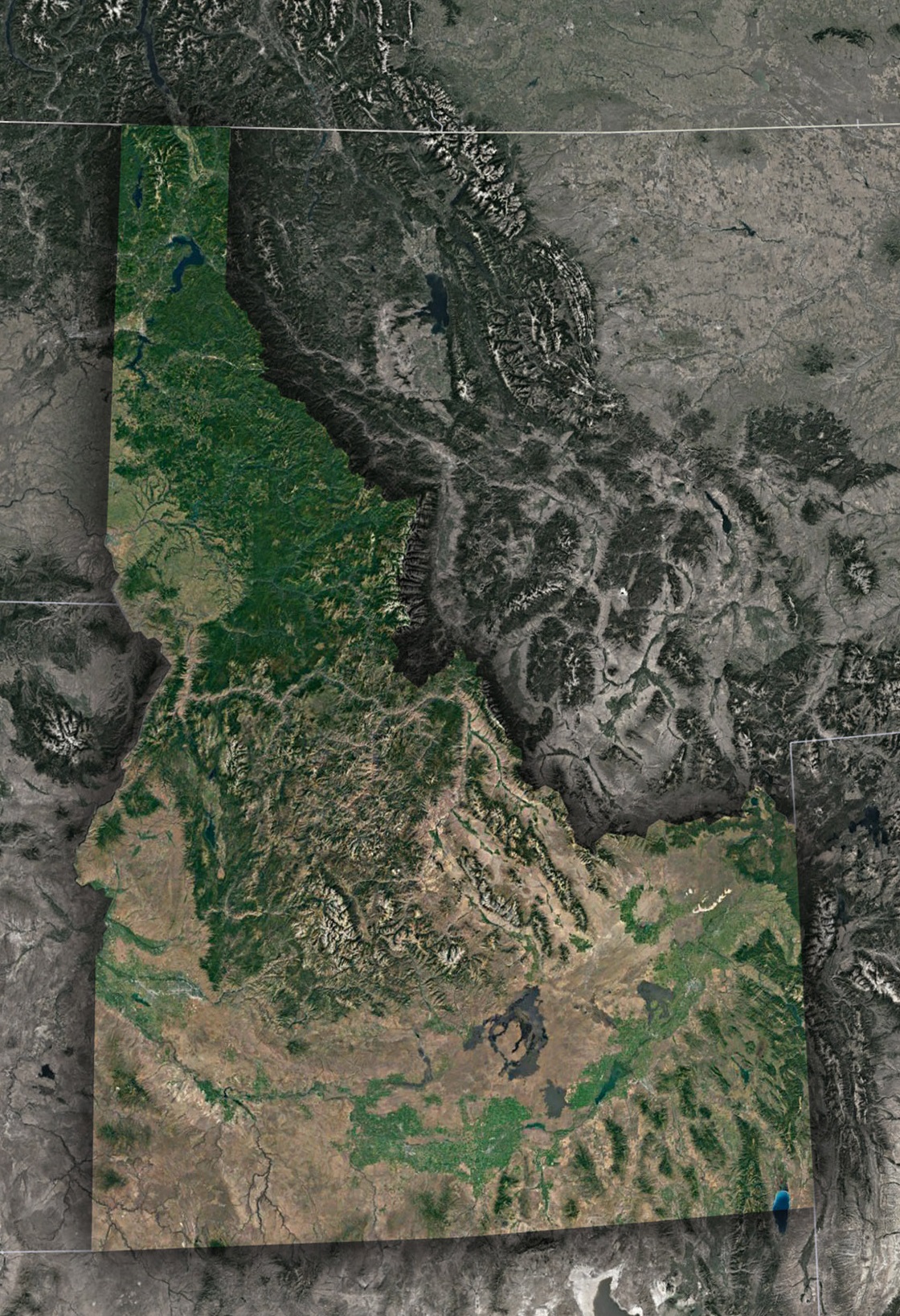 Satellite Map of Idaho
The Snake River Plain-Fertile Valleys and Volcanic History
Venturing westward on Idaho’s 3D map, we arrive at the Snake River Plain, a region characterized by fertile valleys, volcanic features, and the mighty Snake River. This diverse landscape is depicted in exquisite detail, showcasing the gradual elevation changes, the meandering course of the Snake River, and the remnants of ancient volcanic activity.
Elevation gradients reveal the flat expanses of the plain, the lush agricultural fields, and the iconic features such as the Craters of the Moon National Monument. This immersive experience provides a deeper understanding of the geological forces that have shaped this region over millions of years.
The Influence of Waterways-The Snake River and Its Tributaries
Idaho’s 3D topographic map accentuates the role of waterways in shaping the state’s terrain. The Snake River and its tributaries are depicted in striking detail, offering insight into their meandering courses, deep canyons, and the fertile valleys they have carved over time. Understanding their impact on Idaho’s topography is crucial to appreciating the state’s unique geological features and its significance in the region’s ecological balance.
The Influence of Glacial Activity-Legacy of Ice and Glacial Landforms
Idaho’s 3D topographic map highlights the profound impact of glacial activity on the state’s topography. The scars left by retreating glaciers are revealed in exquisite detail, showcasing glacial moraines, U-shaped valleys, and the distinct features shaped by massive ice sheets. Understanding the legacy of glacial activity is essential for appreciating the unique landscapes that characterize Idaho’s interior.
The Geographical Tale of Idaho-A Story of Geological Diversity
Throughout our exploration, it becomes evident that Idaho’s topography is a confirmation to its rich geological history. From the towering peaks of the Rocky Mountains to the volcanic plains of the Snake River, the 3D topographic map tells a story of millions of years of geological evolution.
Unique geological features such as Shoshone Falls and Hell’s Half Acre are intricately woven into the 3D map’s representation, offering insights into the geological forces that continue to shape Idaho’s diverse landscape.
As we conclude our journey through Idaho’s 3D topographic map, we depart with a profound appreciation for the state’s diverse and captivating landscapes. From the rugged mountains to the fertile valleys, Idaho’s topography is a testament to its rich natural heritage.
Understanding Idaho’s 3D topographic map isn’t just about navigation; it’s an invitation to immerse yourself in the state’s geological history, ecological diversity, and cultural significance. Whether you are an intrepid adventurer, a geography enthusiast, or simply someone eager to delve into the wonders of the natural world, Idaho’s 3D topography beckons you to embark on a journey of discovery and wonder, where the landscape springs to life in three dimensions.
Check out WhiteClouds’ 3D Topographic Maps for more information on a topographic map of Idaho. 2D Canvas Print Satellite Maps of Idaho are also available.
Contact us today to learn more about our 3D services and how we can help you achieve your goals.