
Maine’s Natural Tapestry: A Deep Dive into the 3D Topographic Map
Maine, the Pine Tree State, is a treasure trove of natural beauty, where rugged coastlines, pristine lakes, and dense forests converge to create a landscape of unparalleled charm. In this comprehensive exploration, we embark on an immersive journey through the 3D topographic map of Maine, peeling back the layers of its geographical wonders and unraveling the captivating stories etched into its diverse terrain.
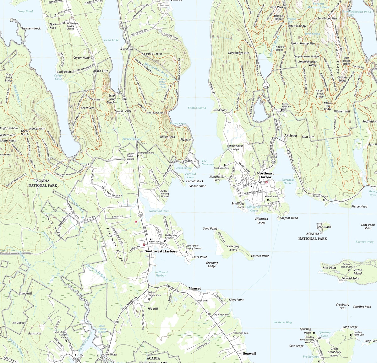 3D Topographic Map of Maine-Southwest Harbor, 1:24,000 quad, 2021, USGS
Navigating the World of 3D Topographic Maps
Before we venture into the heart of Maine’s stunning landscapes, it’s essential to understand the essence of 3D topographic maps. These advanced cartographic tools provide an immersive representation of the Earth’s surface, revealing elevation, terrain, and natural features with remarkable precision. Unlike traditional maps, 3D maps bring Maine’s landscapes to life, offering a unique perspective that allows us to explore the state’s geography in a whole new dimension.
Elevation: The Vertical Perspective
One of the most remarkable features of 3D topographic maps is their ability to depict elevation with astonishing accuracy. In Maine, where elevation ranges from the lowlands of the Atlantic coast to the peaks of the Appalachian Mountains, this dimension is paramount in understanding the state’s unique topography. From the lowest coastal areas to the highest mountain summits, 3D maps vividly illustrate the vertical aspect of Maine’s terrain.
Terrain Visualization: A New Perspective
3D topographic maps offer an immersive experience by bringing Maine’s terrain to life. Every hill, valley, and river is presented with stunning detail, allowing us to appreciate the intricacies of the state’s geography. This unique perspective enables us to uncover hidden features, understand the impact of geological forces, and grasp the interconnectedness of Maine’s landscapes in ways that traditional maps simply cannot convey.
 3D Topographic Map
The Coastal Beauty
Rugged Coastlines and Islands
Our journey through Maine’s 3D topographic map commences with the state’s iconic coastline, stretching for more than 3,000 miles along the Atlantic Ocean. This intricate shoreline is brought to life through the 3D representation, with elevation contours revealing the rocky cliffs, sheltered coves, and the countless islands that dot the coast.
Exploring the 3D map, we can virtually traverse this stunning coastline, appreciating the deep bays, tidal estuaries, and the unique topography shaped by millennia of coastal processes.
Acadia National Park: A Coastal Gem
The 3D topographic map vividly portrays Acadia National Park, a coastal wonderland where visitors can virtually hike along rugged trails, scale iconic cliffs, and take in breathtaking views. This immersive visualization offers a unique perspective on the park’s rugged terrain, pristine lakes, and the panoramic vistas that reward those who explore its coastal landscapes.
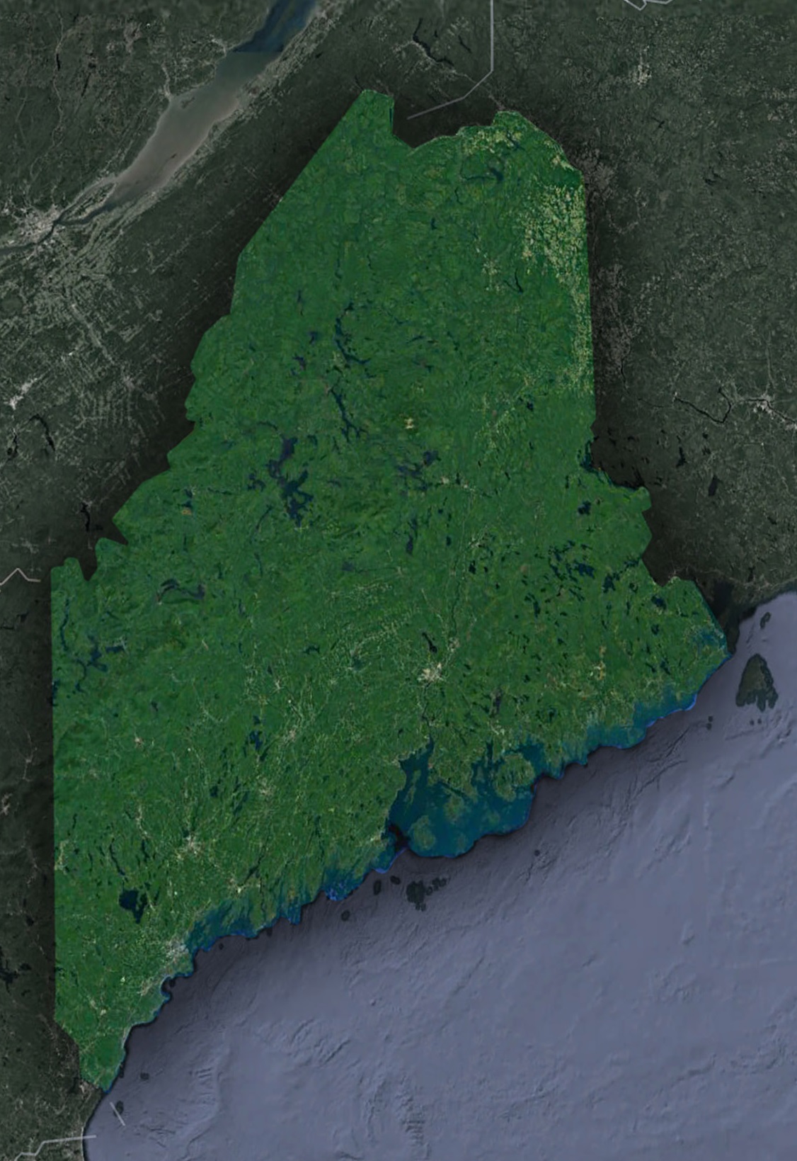 Satellite Map of Maine
The Appalachian Mountains-Majestic Peaks and Wilderness Escapes
Venturing inland on Maine’s 3D map, we arrive at the Appalachian Mountains, a region known for its majestic peaks, dense forests, and pristine lakes. This mountainous terrain is depicted with remarkable detail, showcasing the gradual elevation changes, rolling hills, and the wild beauty that defines this region’s topography.
Elevation gradients reveal the towering summits of Mount Katahdin, Maine’s highest peak, and the vast network of trails and lakes that make this region a haven for outdoor enthusiasts. This immersive experience provides a deeper understanding of the geological forces that have shaped the Appalachian Mountains.
The Influence of Waterways-Rivers, Lakes, and Waterfront Magic
Maine’s 3D topographic map accentuates the role of waterways in shaping the state’s terrain. The rivers, lakes, and streams are depicted with striking detail, offering insight into their meandering courses, deep valleys, and the lush forests they nurture. Understanding their impact on Maine’s topography is crucial to appreciating the state’s unique geological features and its significance in the region’s ecological balance.
The Influence of Glacial Activity-Legacy of Ice and Moraine Landscape
Maine’s 3D topographic map highlights the profound impact of glacial activity on the state’s topography. The scars left by retreating glaciers are revealed in exquisite detail, showcasing moraines, kettle lakes, and the distinct features shaped by massive ice sheets. Understanding the legacy of glacial activity is essential for appreciating the unique landscapes that characterize Maine’s interior.
The Geographical Heritage of Maine-A Story of Geological Diversity
Throughout our exploration, it becomes evident that Maine’s topography is a testament to its rich geological history. From the rugged coastlines to the pristine lakes, the 3D topographic map tells a story of millions of years of geological evolution.
Unique geological features such as Gulf Hagas and Mount Desert Island are intricately woven into the 3D map’s representation, offering insights into the geological forces that continue to shape Maine’s diverse landscape.
As we conclude our journey through Maine’s 3D topographic map, we depart with a profound appreciation for the state’s diverse and captivating landscapes. From the rugged coastlines to the towering peaks of the Appalachian Mountains, Maine’s topography is a testament to its rich natural heritage.
Understanding Maine’s 3D topographic map isn’t just about navigation; it’s an invitation to immerse yourself in the state’s geological history, ecological diversity, and cultural significance. Whether you are an intrepid adventurer, a geography enthusiast, or simply someone eager to delve into the wonders of the natural world, Maine’s 3D topography beckons you to embark on a journey of discovery and wonder, where the landscape springs to life in three dimensions.
Check out WhiteClouds’ 3D Topographic Maps for more information on a topographic map of Maine. 2D Canvas Print Satellite Maps of Maine are also available.
Contact us today to learn more about our 3D services and how we can help you achieve your goals.