
Exploring South Africa’s Geological Marvels: A Journey Through the 3D Geological Map
South Africa, known as the Rainbow Nation, is a land of extraordinary geological diversity, where ancient rocks, majestic mountains, and vibrant landscapes tell a rich and captivating story. In this comprehensive exploration, we embark on an immersive journey through the 3D geological map of South Africa, unveiling the secrets of its geological formations and unraveling the fascinating narratives etched into its terrain.
Understanding Geological Maps
Before delving into South Africa’s geological wonders, it’s essential to grasp the fundamentals of geological maps. These specialized maps provide a comprehensive representation of the Earth’s geological features, including rock types, structures, and mineral deposits. A 3D geological map takes this understanding to the next level, offering a three-dimensional view of the Earth’s subsurface, allowing us to explore geological formations with unprecedented detail and clarity.
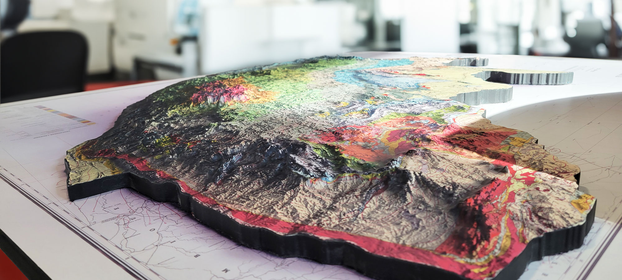 Total size measures 52″ wide by 39′ high and a total depth of 2.5″.
The Importance of Geological Mapping
Geological mapping plays a vital role in understanding the Earth’s history, resources, and natural hazards. In South Africa, where geological complexity abounds, accurate mapping is essential for mineral exploration, land-use planning, and environmental management. By examining geological maps, researchers can decipher the processes that have shaped the landscape over millions of years, providing invaluable insights into the country’s geological heritage.
Interpreting Geological Symbols and Colors
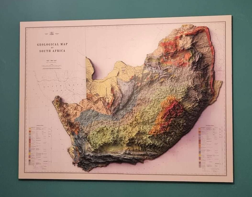
Geological maps use symbols and colors to represent different rock types, structures, and geological features. Understanding these symbols is crucial for interpreting geological maps accurately. In South Africa’s 3D geological map, vibrant colors depict the country’s diverse geological formations, from ancient Precambrian rocks to younger sedimentary deposits. By deciphering these symbols, we can unlock the geological history of South Africa’s landscapes and unravel the secrets hidden beneath its surface.
The Precambrian Basement Complex
Ancient Rocks and Mineral Wealth
Our journey through South Africa’s 3D geological map begins with the Precambrian Basement Complex, a vast region of ancient rocks that forms the foundation of the country’s geology. This complex terrain is rich in mineral resources, including gold, platinum, and diamonds, which have shaped the nation’s economy and history.
Elevation gradients reveal the undulating topography of the Basement Complex, with rugged mountains, deep valleys, and rocky outcrops scattered across the landscape. This immersive experience provides a deeper understanding of the geological processes that have shaped South Africa’s mineral-rich terrain over billions of years.
The Barberton Greenstone Belt: A Window into the Past
The 3D geological map vividly portrays the Barberton Greenstone Belt, a region renowned for its ancient rocks and evidence of early life on Earth. This geological wonderland is depicted in exquisite detail, showcasing the intricate layering of sedimentary rocks, the remnants of ancient volcanic activity, and the fossils of some of the Earth’s earliest organisms.
Elevation gradients reveal the rugged terrain of the Greenstone Belt, with steep cliffs, deep gorges, and rocky escarpments that bear witness to the geological forces that have shaped this region over billions of years. This immersive visualization offers a unique perspective on the Barberton Greenstone Belt’s geological significance and its contribution to our understanding of Earth’s history.
The Cape Fold Belt-Majestic Mountains and Geological Contrasts
Venturing southward on South Africa’s 3D geological map, we arrive at the Cape Fold Belt, a region known for its majestic mountains, scenic valleys, and geological contrasts. This mountainous terrain is depicted in remarkable detail, showcasing the intricate folding and faulting that have shaped the landscape over millions of years.
Elevation gradients reveal the towering peaks of the Cape Fold Belt, with rugged cliffs, deep valleys, and meandering rivers that carve through the ancient rocks. This immersive experience provides a deeper understanding of the geological forces that have shaped South Africa’s iconic landscapes and contributed to its geological diversity.
The Karoo Basin-Desert Landscapes and Fossil Treasures
Turning our attention to the interior of South Africa, we encounter the Karoo Basin, a vast region of desert landscapes, rolling plains, and fossil-rich deposits. This geological wonderland is depicted in striking detail, showcasing the gradual sedimentation that has preserved a record of life spanning millions of years.
Elevation gradients reveal the flat expanse of the Karoo Basin, with ancient river channels, dry lake beds, and the remnants of ancient ecosystems that provide invaluable insights into South Africa’s geological history. This immersive visualization offers a unique perspective on the Karoo Basin’s geological significance and its contribution to our understanding of Earth’s past.
The Influence of Waterways-Rivers, Lakes, and Coastal Features
South Africa’s 3D geological map accentuates the role of waterways in shaping the country’s terrain. The rivers, lakes, and coastal features are depicted with striking detail, offering insight into their meandering courses, deep valleys, and the unique landscapes they have carved over time. Understanding their impact on South Africa’s topography is crucial to appreciating the country’s geological diversity and its significance in the region’s ecological balance.
The Geographical Heritage of South Africa-A Story of Geological Evolution
Throughout our exploration, it becomes evident that South Africa’s topography is a testament to its rich geological history. From the ancient rocks of the Precambrian Basement Complex to the majestic mountains of the Cape Fold Belt, the 3D geological map tells a story of billions of years of geological evolution.
Unique geological features such as Table Mountain and the Vredefort Dome are intricately woven into the 3D map’s representation, offering insights into the geological forces that continue to shape South Africa’s diverse landscape.
Conclusion
As we conclude our journey through South Africa’s 3D geological map, we depart with a profound appreciation for the country’s diverse and captivating landscapes. From the ancient rocks of the Precambrian Basement Complex to the scenic valleys of the Cape Fold Belt, South Africa’s geological heritage is a confirmation to its rich natural history.
Understanding South Africa’s 3D geological map isn’t just about navigation; it’s an invitation to immerse yourself in the country’s geological history, explore its mineral wealth, and unravel the secrets hidden beneath its surface. Whether you are a geology enthusiast, a researcher, or simply someone eager to delve into the wonders of the natural world, South Africa’s 3D geological map beckons you to embark on a journey of discovery and wonder, where the Earth’s geological history unfolds in three dimensions.
Contact us today to learn more about our 3D services and how we can help you achieve your goals.