
A New Dimension in Park Exploration: Malibu Creek’s 3D Map Unveiling
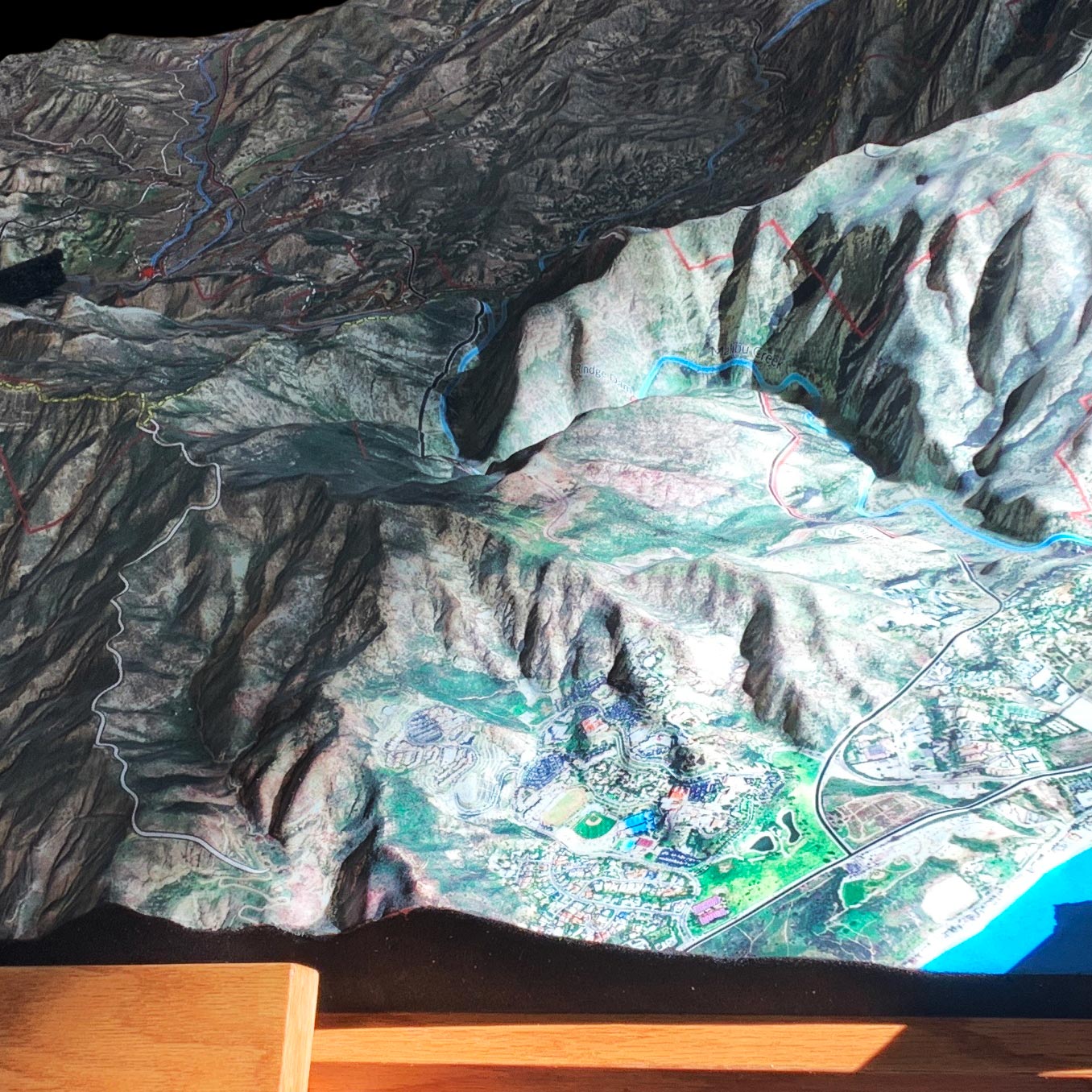
On a crisp November day in 2023, the Malibu Creek Docents, with a generous grant from the California State Parks Foundation, introduced a groundbreaking addition to the Malibu Creek State Park Visitor Center. This was not just any addition, but a leap into the future of park exploration—a meticulously crafted 3D map created by the innovative team at WhiteClouds. This remarkable piece of art and technology offers visitors a unique, bird’s-eye view of the park’s sprawling beauty, combining the magic of customized satellite imagery with the tactile experience of a model you can explore with your fingertips.
The Genesis of the Map
The journey to this unveiling began with the Malibu Creek Docents’ vision to enhance the visitor experience through a tangible, interactive representation of the park. With the support of the California State Parks Foundation, they approached WhiteClouds, a company renowned for its expertise in bringing digital landscapes to life. The mission was clear: to create a 3D map that not only guides but also educates and inspires all who come to explore the natural wonders of Malibu Creek State Park.

Crafting the Vision
Armed with detailed maps and a plethora of specific data points provided by the Malibu Creek Docents (MCD) and the diligent staff of California State Parks, WhiteClouds embarked on the meticulous task of rendering the park’s topography. The challenge was to translate the wealth of information—trails, creeks, points of interest, and the park’s boundaries—into a visual language that speaks to both the casual visitor and the seasoned hiker. Through a collaborative process, where precision met artistic flair, the final design took shape, promising an immersive exploration experience.
A Model of Innovation and Accessibility
Standing at an impressive 42 inches in length, 50 inches in width, and 38 inches in height, the completed 3D map is a testament to both innovation and craftsmanship. It is perched atop an ADA-compliant oak wood pedestal, making it accessible to all visitors, inviting them to delve into the park’s geography with ease and curiosity. The map’s design utilizes customized satellite imagery, intricately overlaid by hand to capture the park’s diverse terrain, from its meandering trails and flowing creeks to the designated points of interest that beckon adventurers.

Beyond a Map: A Portal to Discovery
Now proudly displayed in the Visitor Center, the map does more than orient—it transforms the visitor experience, providing a portal to the park’s vast expanses before even setting foot on an actual trail. It stands as a bridge between the digital and the natural world, allowing visitors to visually and tactically engage with the park’s features. This innovative tool not only enhances the park experience but also serves as a model for how technology and traditional outdoor activities can merge to create something truly spectacular.
A Legacy of Learning and Exploration
The unveiling of the 3D map at Malibu Creek State Park marks a new chapter in the park’s storied history—one that embraces technology to foster a deeper connection with nature. It is a legacy of learning, inviting visitors to explore, understand, and appreciate the natural beauty that surrounds them, with every ridge, valley, and waterway laid out before their eyes.
As visitors gather around this remarkable map, they are not just seeing a model of the park; they are witnessing the future of environmental education and engagement. This map is more than a navigational aid; it is an invitation to adventure, a call to explore, and a reminder of the wonders that await in the great outdoors. Through the collaborative efforts of the Malibu Creek Docents, WhiteClouds, and the California State Parks Foundation, the Visitor Center now houses a gateway to discovery, blending the art of cartography with the innovation of 3D printing to guide, inspire, and educate every soul that seeks the beauty of Malibu Creek State Park.
Contact us today to learn more about our 3D services and how we can help you achieve your goals.