
Turning Flat Information Into Living Form
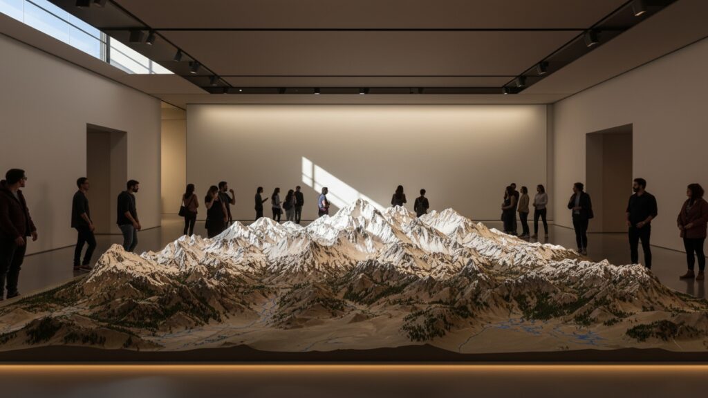
A contour model is a powerful way of transforming flat data into a physical or visual form that people can truly understand. It takes lines, measurements, and elevation values and turns them into shape, depth, and dimension. Where a map shows you information on a page or screen, a contour model lets you see and often feel how the land rises, falls, and flows. At its heart, a contour model is a three-dimensional representation of terrain or surface form created from contour data. Contour lines—those looping lines you see on topographic maps—represent points of equal elevation. A contour model stacks, sculpts, or digitally renders those elevations into a physical or virtual landscape. Hills emerge. Valleys sink. Ridges stretch across space. Suddenly, geography becomes intuitive. Contour models are used across architecture, engineering, education, urban planning, environmental science, military strategy, and even art. They bridge the gap between abstract numbers and human perception, helping people understand complex spatial relationships in seconds rather than hours.
The Origins of Contour Modeling
The concept behind contour models has deep roots in cartography and surveying. Long before computers, engineers and planners relied on hand-drawn contour maps to understand terrain. These maps were invaluable, but interpreting them required training and imagination. Skilled professionals could visualize slopes and elevations mentally, but for many others, the information remained abstract. Physical contour models emerged as a solution. Early versions were crafted from stacked cardboard, wood, plaster, or clay, carefully cut or shaped to match contour intervals from maps. These models allowed planners, military strategists, and architects to gather around a table and instantly grasp the lay of the land. As technology advanced, contour modeling evolved alongside it. What began as hand-built terrain models is now enhanced by digital elevation data, CNC machines, laser cutters, and 3D printing. Yet the core purpose remains unchanged: making terrain understandable at a glance.
What Exactly Is a Contour Model?
A contour model is a three-dimensional interpretation of contour data, typically derived from topographic maps or elevation datasets. Each layer or surface corresponds to a specific elevation, and together they recreate the form of the land or object being studied.
Unlike a simple scale model that focuses on buildings or structures, a contour model emphasizes surface variation. Slopes, ridgelines, basins, plateaus, and drainage paths become the stars of the show. This makes contour models especially valuable for understanding how water flows, how land can be developed, and how natural forces shape environments.
Contour models can be physical objects you place on a table or digital renderings you explore on a screen. Both serve the same purpose: revealing the invisible logic of elevation and form.
Contour Models vs. Topographic Maps
Topographic maps and contour models are closely related, but they communicate information in very different ways. A topographic map uses contour lines to represent elevation changes on a flat surface. Interpreting those lines requires practice, spatial reasoning, and experience.
A contour model removes that barrier. Instead of translating lines into imagined shapes, the viewer sees the shapes directly. Steep slopes appear steep. Gentle hills feel gentle. Valleys naturally guide the eye along their path.
While topographic maps excel at precision and portability, contour models excel at comprehension. For presentations, education, and collaborative planning, contour models often communicate terrain more quickly and clearly than maps alone.
How Contour Models Are Made
Creating a contour model starts with elevation data. This data may come from traditional surveys, satellite imagery, LiDAR scans, or digital elevation models. Once the data is gathered, it is translated into contour intervals that define elevation steps.
In physical models, these intervals are often represented as stacked layers. Each layer corresponds to a specific height and is cut from materials such as foam board, wood, acrylic, or cardboard. When stacked and aligned, the layers form a stepped version of the terrain, which can be left exposed or smoothed for a more natural appearance.
Digital contour models follow a similar logic but use software instead of physical materials. Elevation data is processed into 3D surfaces that can be rotated, zoomed, and analyzed. These digital models can also be converted into files for CNC machining or 3D printing, blending the digital and physical worlds.
Materials Commonly Used in Physical Contour Models
The choice of material plays a major role in how a contour model looks and feels.
- Foam board is popular for its lightweight nature and ease of cutting. It’s often used in architectural studios and classrooms where speed and clarity matter more than durability.
- Wood offers a more refined and permanent look. Laser-cut plywood or MDF layers create striking visual models that are often displayed in museums, visitor centers, or design presentations.
- Acrylic adds a modern, translucent quality that can highlight layers and elevation changes in a dramatic way.
- Plaster, clay, and resin are used when a smoother, sculpted finish is desired. These materials allow for blending contours into continuous surfaces, making the terrain appear more realistic.
Each material choice reflects the model’s purpose, audience, and environment.
Contour Models in Architecture and Urban Planning
In architecture and urban planning, contour models are invaluable tools. They help designers understand how buildings will interact with the land rather than fighting against it. Slope, drainage, and elevation differences all influence design decisions, and contour models make these factors visible early in the process.
Planners use contour models to study how neighborhoods fit into larger landscapes. Roads, utilities, and public spaces can be evaluated in relation to natural features, reducing costly mistakes and improving long-term sustainability. When stakeholders gather around a contour model, conversations become more productive because everyone shares the same visual reference.
These models also help communicate ideas to non-experts. Community members may not understand technical drawings, but they can instantly grasp a physical model that shows how development will affect their surroundings.
Engineering, Infrastructure, and Contour Models
Engineers rely heavily on contour models when designing infrastructure. Roads, bridges, dams, and pipelines all interact with terrain in complex ways. A contour model reveals where cuts and fills may be required, where erosion risks exist, and how water will move across the land.
In flood control and drainage planning, contour models are especially valuable. They show low points where water may collect and high points that act as natural barriers. By studying these forms, engineers can design systems that work with gravity rather than against it. Contour models reduce uncertainty and support safer, more efficient engineering solutions by making terrain behavior easier to predict.
Educational Uses of Contour Models
Contour models are powerful teaching tools. In classrooms, they transform abstract geography lessons into hands-on experiences. Students can touch the terrain, trace ridges with their fingers, and immediately understand concepts like watersheds and elevation gradients. Science museums and nature centers often use contour models to explain landscapes, volcanoes, river systems, and mountain ranges. These models invite exploration and curiosity, encouraging visitors to engage with complex ideas through observation rather than text. By appealing to visual and tactile learners, contour models make geography, geology, and environmental science more accessible and memorable.
Contour Models in Environmental and Land Analysis
Environmental scientists use contour models to study ecosystems, erosion patterns, and land-use impacts. Terrain influences everything from plant growth to wildlife movement, and contour models make these relationships visible.
When assessing environmental risk, such as landslides or flooding, contour models help identify vulnerable areas. They support planning decisions that balance development with conservation, guiding actions that protect both people and natural systems. In land restoration projects, contour models help visualize how reshaping terrain can restore natural water flow and habitat function. They become tools for healing landscapes as much as analyzing them.
Digital Contour Models and Modern Technology
Digital contour models have expanded what’s possible in terrain visualization. With advanced software, users can manipulate elevation data in real time, testing scenarios and visualizing outcomes instantly. Slopes can be exaggerated, water flow simulated, and shadows cast to show how sunlight interacts with terrain.
These models are often integrated into Geographic Information Systems, allowing terrain to be analyzed alongside zoning, infrastructure, and environmental data. This layered approach supports smarter, data-driven decisions across many industries.
Virtual and augmented reality technologies are also beginning to bring contour models into immersive environments. Users can step into a landscape, experiencing elevation changes at human scale, which opens new possibilities for design and education.
Artistic and Sculptural Uses of Contour Models
Beyond technical fields, contour models have found a home in art and sculpture. Artists use contour layering to explore form, repetition, and abstraction. Landscapes become rhythmic patterns of lines and planes, blurring the line between map and sculpture. Public installations and gallery pieces often use contour models to celebrate regional geography or provoke reflection on humanity’s relationship with land. These works invite viewers to see familiar places from new perspectives, emphasizing shape and structure over detail. In this way, contour models transcend utility and become expressions of place and identity.
Reading and Interpreting a Contour Model
Understanding a contour model is often intuitive, but there’s depth beneath the surface. Higher areas rise physically or visually, while lower areas recede. The spacing between layers or contours indicates slope; closely spaced layers suggest steep terrain, while wider spacing suggests gentle slopes.
Valleys and ridges become immediately apparent. Water flow can often be inferred by following the natural channels formed by the terrain. With a bit of practice, viewers can extract a wealth of information from even a simple model.
Contour models encourage exploration. Rotating the model, viewing it from different angles, or changing lighting can reveal new insights and relationships.
Common Misconceptions About Contour Models
One common misconception is that contour models are purely decorative. While they can be beautiful, their primary purpose is functional. They convey information in ways that other formats cannot.
Another misunderstanding is assuming that all contour models are perfectly accurate. Like any model, they are simplifications. The level of detail depends on contour intervals, data quality, and scale. Understanding these limitations helps users interpret models responsibly. Contour models are tools for insight, not replacements for detailed measurements or field verification.
The Role of Scale in Contour Models
Scale is one of the most important aspects of a contour model. A small-scale model might show an entire region, emphasizing broad landforms. A large-scale model might focus on a single site, revealing subtle changes in elevation that affect design decisions.
Choosing the right scale depends on the model’s purpose. Educational models often favor clarity and simplicity, while professional models prioritize precision. Understanding scale ensures that the model communicates the intended message effectively.
The Future of Contour Modeling
As data collection becomes more precise and tools more accessible, contour models are becoming easier to create and more powerful than ever. High-resolution elevation data allows for incredibly detailed representations of terrain, while digital fabrication technologies bring those representations into the physical world with remarkable accuracy.
Future contour models may update in real time, reflecting changes caused by construction, erosion, or climate events. They may integrate seamlessly with simulation tools, helping communities plan for resilience and adaptation.
Despite these advances, the essence of contour modeling remains unchanged: turning complex terrain data into forms that people can see, understand, and act upon.
Why Contour Models Continue to Matter
In a world overflowing with information, clarity is priceless. Contour models cut through complexity by showing rather than telling. They transform numbers into shapes, data into landscapes, and questions into insights. Whether used to design cities, teach students, protect ecosystems, or create art, contour models connect people to the physical world in meaningful ways. They remind us that the land beneath our feet has form, structure, and story—and that understanding it begins with seeing it clearly.


