

Florida, with its sun-kissed beaches, lush wetlands, and vibrant wildlife, is an enchanting state that draws millions of visitors every year. Located at the southeastern tip of the United States, Florida boasts a subtropical climate that is ideal for outdoor activities year-round. As shown on various Florida maps, the state’s diverse geography, natural features, and man-made structures make it a popular destination for tourists, residents, and professionals in various fields.
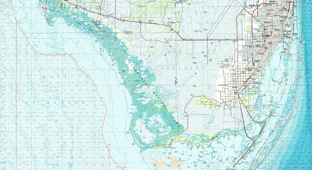
One of the most fascinating aspects of Florida is its diverse natural features. With over 1,300 miles of coastline, Florida is famous for its sandy beaches, crystal-clear waters, and abundant marine life. From the bustling beaches of Miami to the secluded shores of the Florida Panhandle, there is a beach for every taste. However, Florida is not just about beaches. The state is also home to the Everglades, a vast wetland ecosystem that is unlike any other place on earth. The Everglades are home to a wide range of plant and animal species, including alligators, panthers, and manatees, and exploring this unique landscape is an unforgettable experience.
Beyond its natural beauty, Florida is also a state of impressive man-made structures. The bustling city of Miami boasts a skyline of towering buildings that is a testament to human engineering and creativity. In addition to its urban landscape, Florida is also home to a variety of other man-made structures, such as the Kennedy Space Center, which has played a key role in the history of space exploration.
Whether you’re planning a family vacation, a solo adventure, or a corporate retreat, navigating Florida can be a challenge without the help of accurate maps. Fortunately, a variety of maps of Florida have been created to help you explore the state’s many treasures. From topographic maps that detail the elevation and contours of the land to road maps that show the highways and byways of the state, there is a Florida map for every need.
Check out our many various maps of Florida and let the adventure begin!
Florida City Maps
Florida is home to several large cities, including Miami, Orlando, Tampa, and Jacksonville, each with its own distinct personality and attractions. Whether you are a resident or a tourist, having a map of Florida’s cities can be incredibly helpful when navigating your way around the state.
One of the best resources for finding maps of Florida’s cities is the internet. Several websites offer detailed maps of the state’s major cities, including street names, landmarks, and major highways. Some of these websites even allow you to zoom in and out to get a closer look at specific areas.
- To learn how 2D/3D city maps are built, click here: City Terrain Maps
- Florida City Maps-Canvas Prints
- Florida City USGS Terrain Maps-Canvas Prints
- Florida City USGS Terrain Maps-3D Raised Relief
- Florida City Maps-Google Maps
If you are a fan of traditional paper maps, many travel guides and tourist centers in Florida offer free maps of the state’s cities. These maps are usually easy to read and provide a comprehensive overview of the city, including major points of interest, parks, and other landmarks. They may also include helpful information like public transportation routes and parking options.
Another useful tool for navigating Florida’s cities is GPS technology. Most smartphones and navigation systems offer real-time traffic updates, turn-by-turn directions, and points of interest along your route. This technology can be especially helpful for drivers who are not familiar with the area and want to avoid getting lost.
When using city maps of Florida, it’s important to remember that they are only one tool in your navigation arsenal. It’s always a good idea to research your destination beforehand and plan your route accordingly. Pay attention to landmarks, street signs, and other visual cues that can help guide you to your destination.
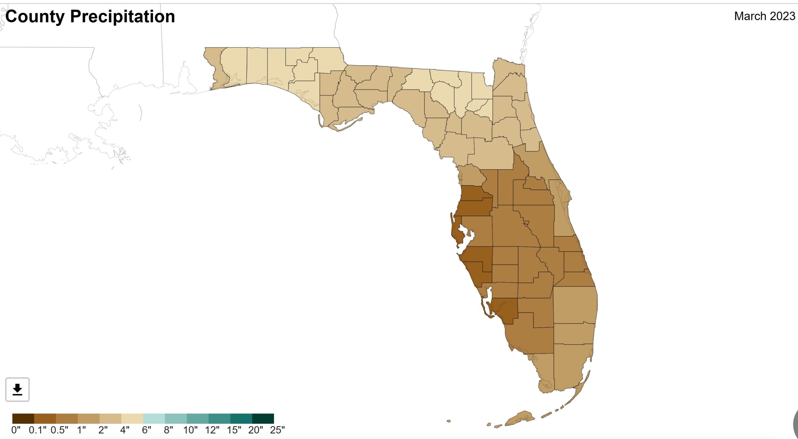
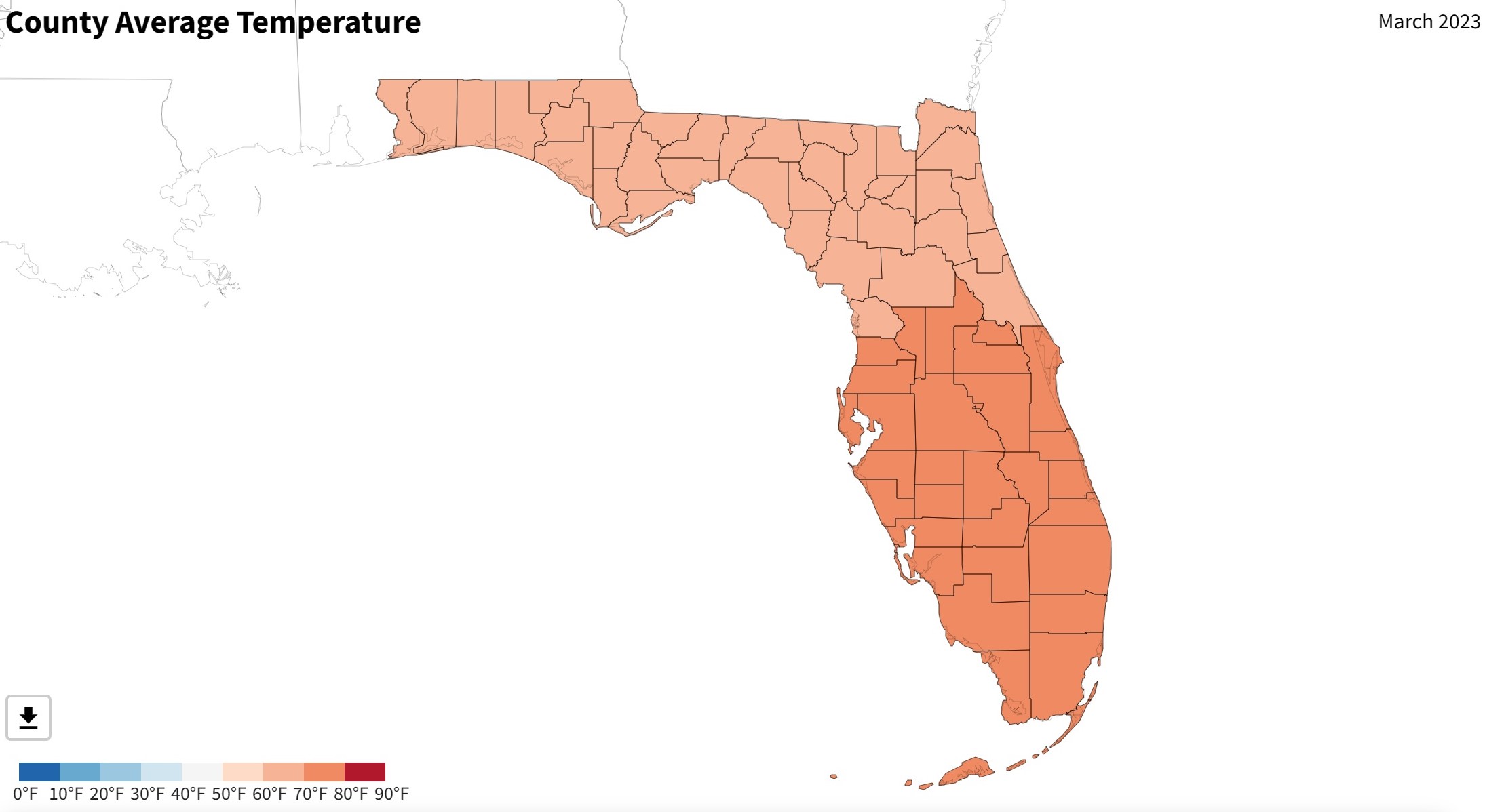
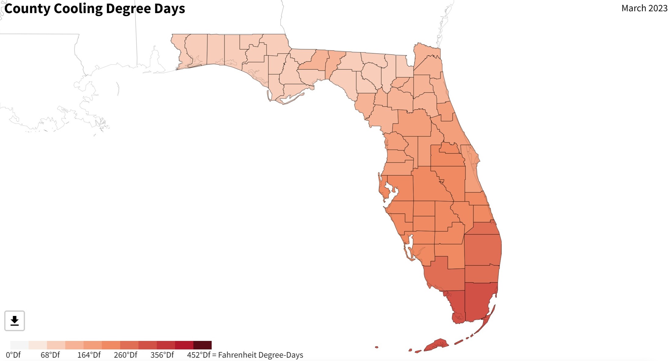
Florida Climate Maps
Florida is known for its sunny beaches, theme parks, and warm weather. However, the state’s climate is more complex than it may seem. Florida’s location on the southeastern coast of the United States puts it in the path of many weather patterns, including hurricanes and thunderstorms.
The Florida Climate Center, part of Florida State University, provides a wealth of information about the state’s climate. One of the center’s most useful resources is its climate maps. These maps show average temperature, precipitation, and other climate data for various regions of Florida.
- To learn how 2D/3D climate maps are built, click here: Satellite Maps
- Florida Climate Maps-Canvas Prints
- Florida Climate Maps-NOAA Climate Maps (National Oceanic and Atmospheric Administration)
One of the most striking features of Florida’s climate maps is the variation in temperature across the state. The southernmost part of Florida, including Miami and the Florida Keys, has a tropical climate. This means that temperatures are warm year-round, with average temperatures in the 80s Fahrenheit (27-32 Celsius) even during the winter months. The northern part of the state, on the other hand, has a subtropical climate, which means that temperatures are cooler in the winter and can even drop below freezing in some areas.
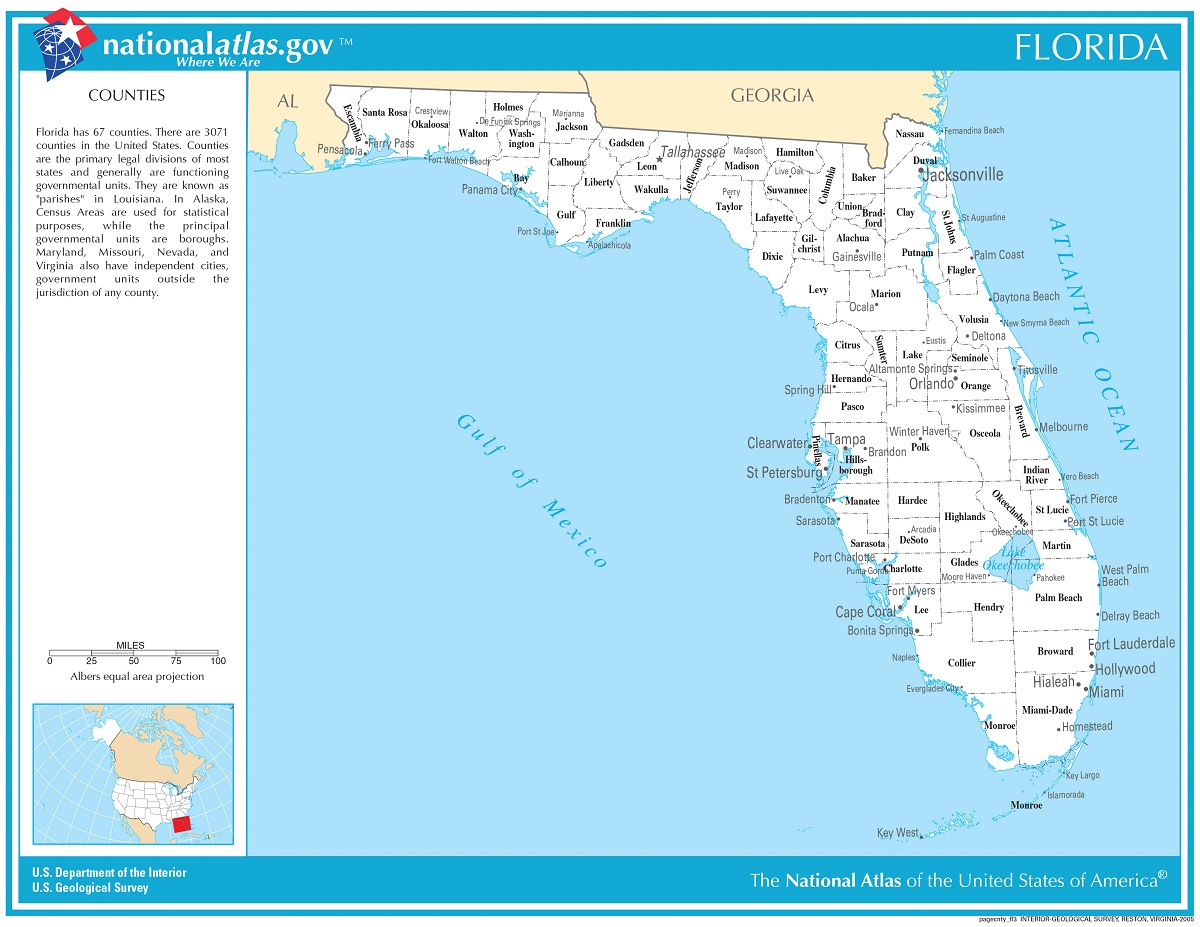
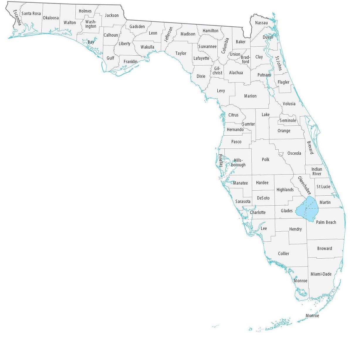
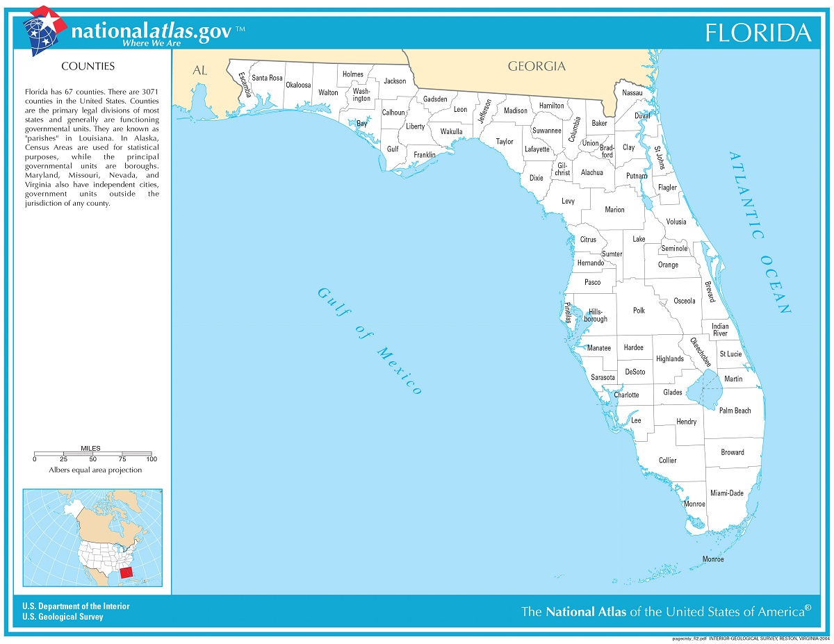
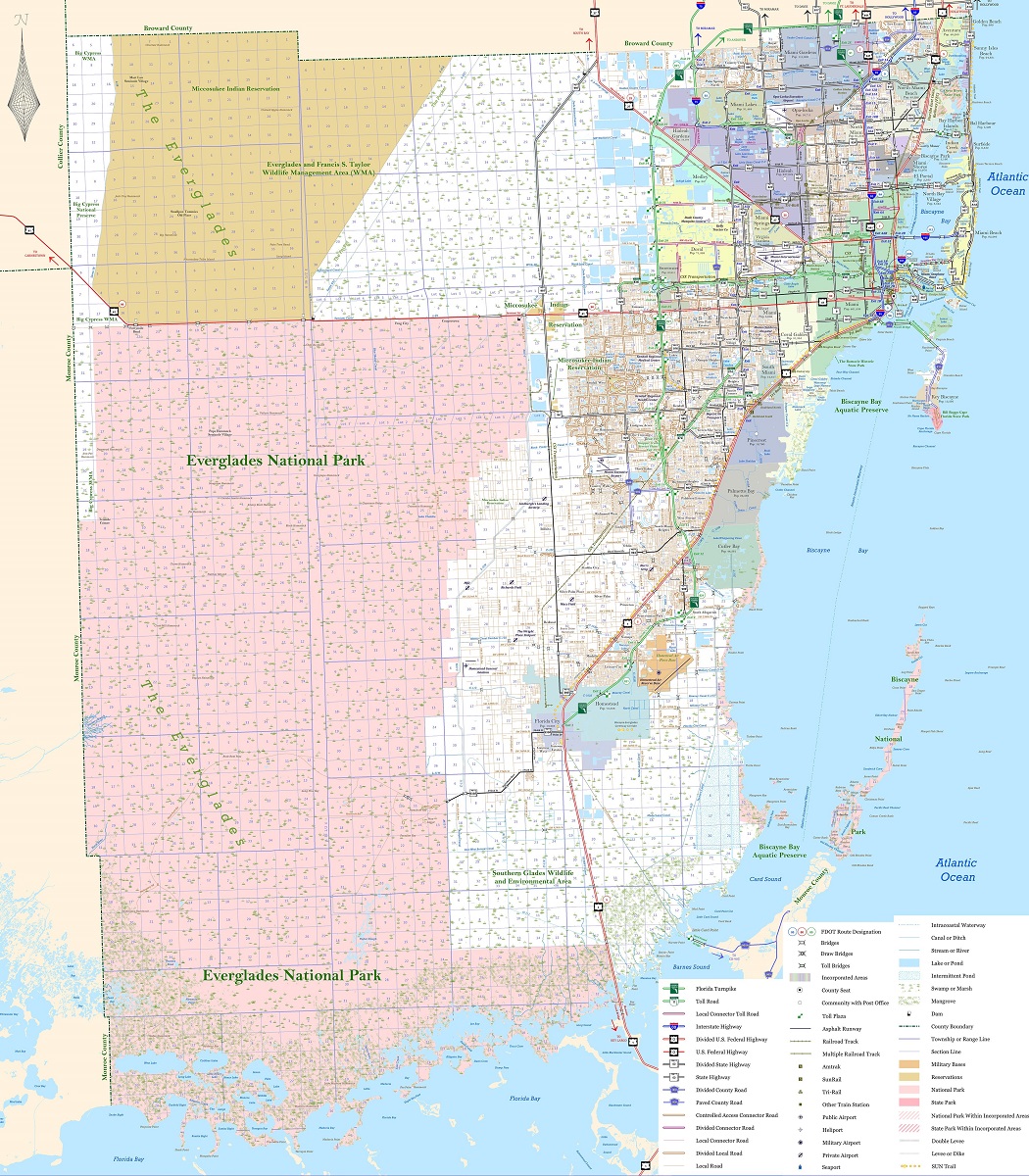
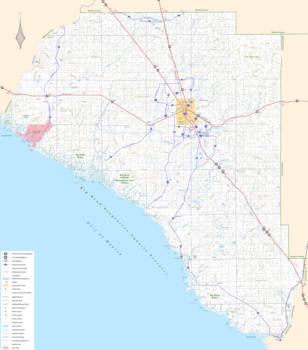
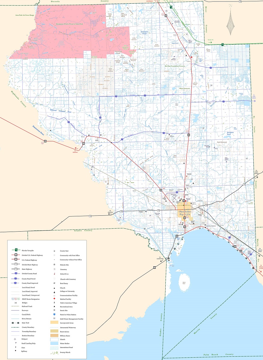
Florida County Maps
Florida has a population of over 21 million people and is one of the most populous states in the country. To help navigate the state’s various regions and counties, Florida county maps are an essential tool.
County maps are a type of map that displays the boundaries and locations of the counties within a state or region. In Florida, there are 67 counties, each with its own unique geography, history, and culture. Florida county maps can be used to explore the state’s various regions and plan road trips or other travel routes.
- To learn how 2D/3D county maps are built, click here: Terrain Maps
- Florida County Maps-Canvas Prints
- Florida County Maps-FDOT (Florida Department of Transportation)
If you are a fan of traditional paper maps, many travel guides and tourist centers in Florida offer free maps of the state’s cities. These maps are usually easy to read and provide a comprehensive overview of the city, including major points of interest, parks, and other landmarks. They may also include helpful information like public transportation routes and parking options.
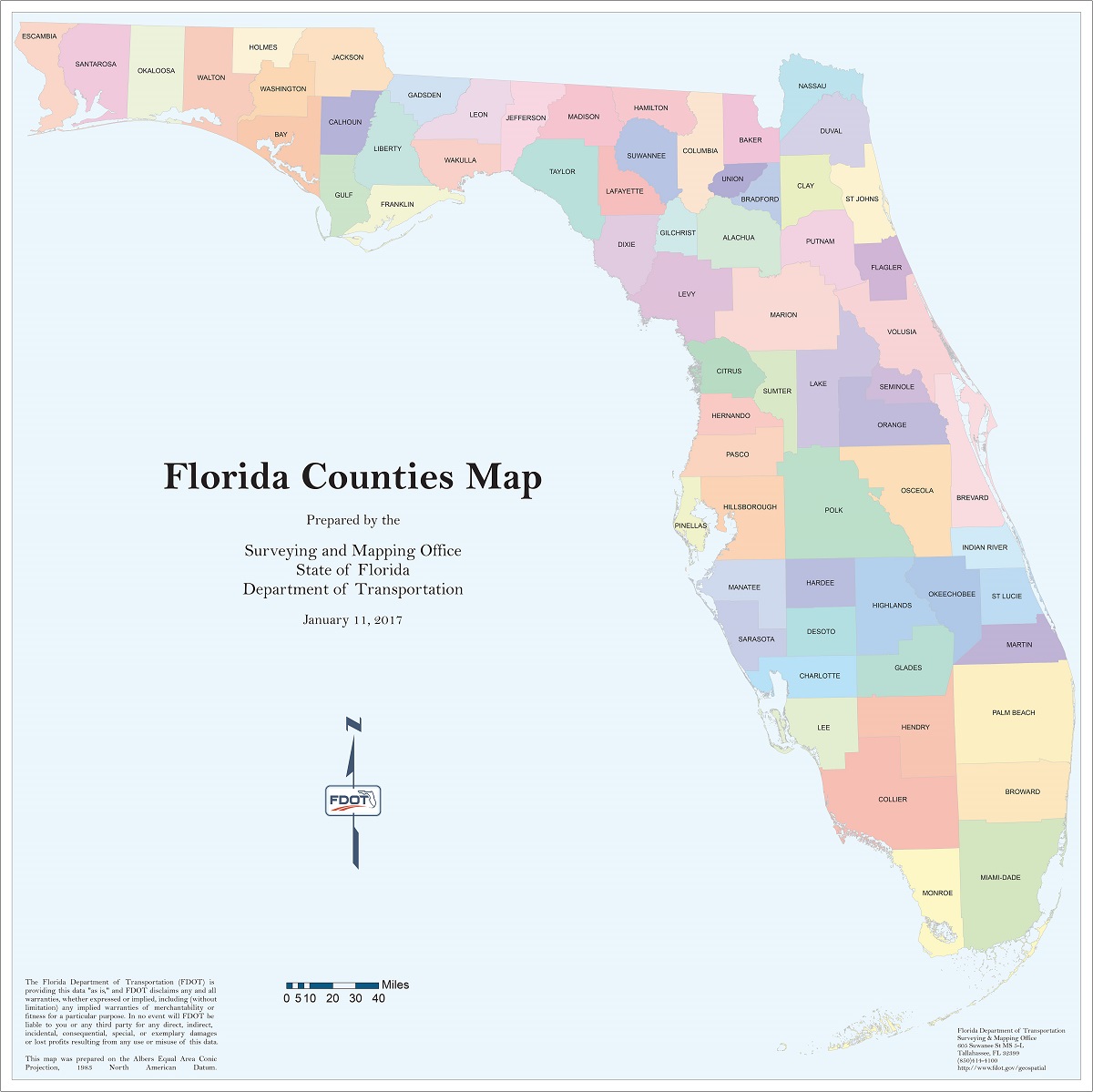
One of the most popular areas of Florida for county mapping is the southern part of the state, which includes Miami-Dade, Broward, and Palm Beach counties. These counties are home to some of Florida’s largest cities, including Miami, Fort Lauderdale, and West Palm Beach. County maps of this region can be used to explore the various neighborhoods, attractions, and landmarks within each county, as well as to plan routes between them.
Another area of Florida that is popular for county mapping is the Panhandle region in the northwest part of the state. This region is known for its beaches, state parks, and outdoor recreation opportunities. County maps of this area can be used to explore the various coastal towns, as well as to plan routes for hiking, kayaking, or other outdoor activities.
Florida county maps can also be useful for exploring the state’s history and culture. For example, maps of St. Augustine, the oldest city in the United States, can be used to locate historic landmarks and attractions. Similarly, maps of the Florida Keys can be used to explore the unique culture and history of this island chain.
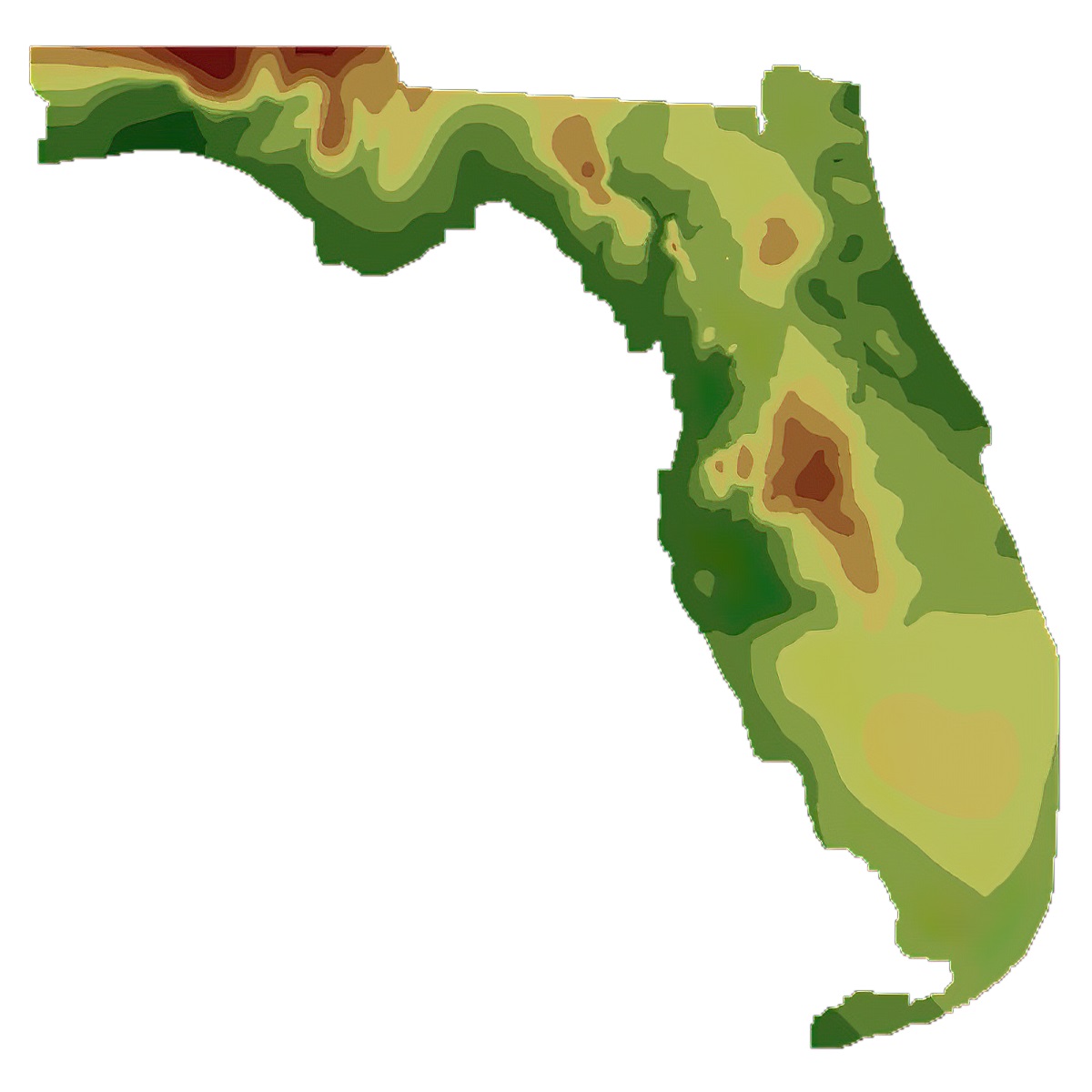
Florida Elevation Maps
Florida is known for its sandy beaches, warm weather, and diverse wildlife. However, one of the lesser-known features of Florida is its varied elevation levels, which can have a significant impact on everything from infrastructure planning to flood risk management.
An elevation map is a representation of the topography of a particular area, typically displayed using contour lines to indicate changes in elevation. In the case of Florida, elevation maps can help to highlight the state’s many low-lying areas, which are prone to flooding during periods of heavy rain or storms.
The highest point in Florida is Britton Hill, which stands at just 345 feet above sea level. In contrast, much of the state’s coastline is at or just above sea level, making it particularly vulnerable to rising sea levels and storm surges.
- To learn how 2D/3D elevation maps are built, click here: Elevation Maps
- Florida Elevation Maps-Florida Department of Environmental Protection
In addition to showing elevation changes, Florida elevation maps can also reveal the state’s various natural features, such as the Everglades, a vast wetland ecosystem that covers much of southern Florida. The Everglades are notable for their shallow, slow-moving waterways, which are fed by the Kissimmee River and Lake Okeechobee.
There are several reasons why Florida elevation maps are important. For one, they can help to inform infrastructure planning and development decisions, such as where to build roads, bridges, and other critical infrastructure projects. By understanding the elevation levels of different areas, planners can identify potential challenges and risks, such as areas that may be more prone to flooding or landslides.
Elevation maps can also be useful for flood risk management. As mentioned, many parts of Florida are at or just above sea level, which makes them particularly vulnerable to flooding during storms or periods of heavy rainfall. By using elevation maps to identify areas that are at risk of flooding, local authorities can take steps to mitigate potential damage, such as building seawalls or installing drainage systems.
Finally, Florida elevation maps can help to inform emergency management and response efforts. During natural disasters such as hurricanes or floods, emergency responders need to be able to quickly assess the potential risks and impact of the event. By using elevation maps to identify vulnerable areas, responders can more effectively allocate resources and coordinate response efforts.
Florida Geology Maps
Florida’s geologic maps are an essential tool for understanding the state’s geological history and the natural resources that are present in its various regions. These maps provide information on the age and composition of rocks, the location of faults and folds, and the distribution of minerals and other geological resources.
- To learn how 2D/3D geology maps are built, click here: Geologic Maps
- Retrieve Florida Geologic Map: Florida Geological Survey
Geologic maps of Florida are typically divided into two main categories: surficial geology maps and bedrock geology maps. Surficial geology maps show the distribution of soils, sediments, and other materials that are found at or near the earth’s surface. These maps are especially useful for understanding the impact of surface processes like erosion and deposition on the state’s landscapes.
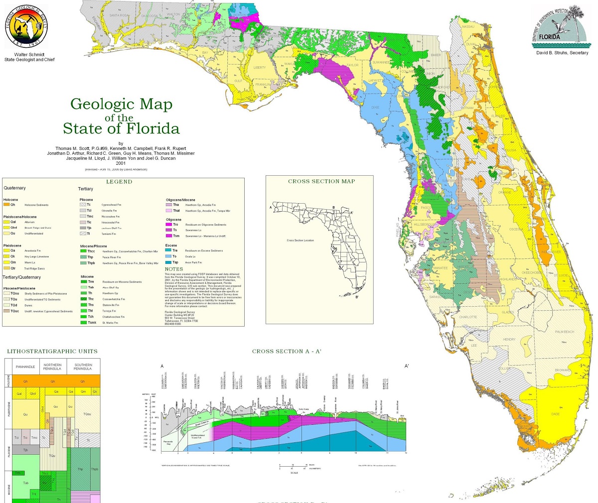
Bedrock geology maps, on the other hand, show the location and distribution of solid rock formations that are present beneath the surface of the earth. These maps are essential for understanding the structure and composition of Florida’s underlying geology, including the presence of valuable minerals and other natural resources.
One of the most important geological features of Florida is the presence of the Florida Platform, which is a large, flat layer of sedimentary rock that underlies much of the state. The Platform is composed of a variety of rock formations, including limestone, dolomite, and sandstone, which have been deposited over millions of years. These rock formations are important sources of groundwater and oil and gas reserves.
In addition to the Florida Platform, there are also many other geological features of interest in the state, including the Ocala Uplift, the Suwannee Basin, and the Everglades. Each of these regions has its own unique geological history and characteristics, which are reflected in the geologic maps of the state.
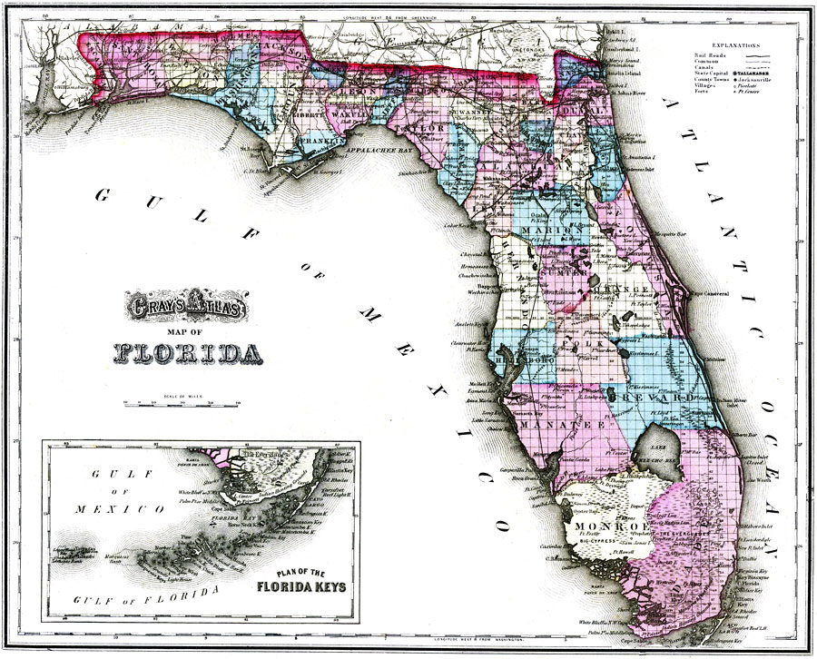
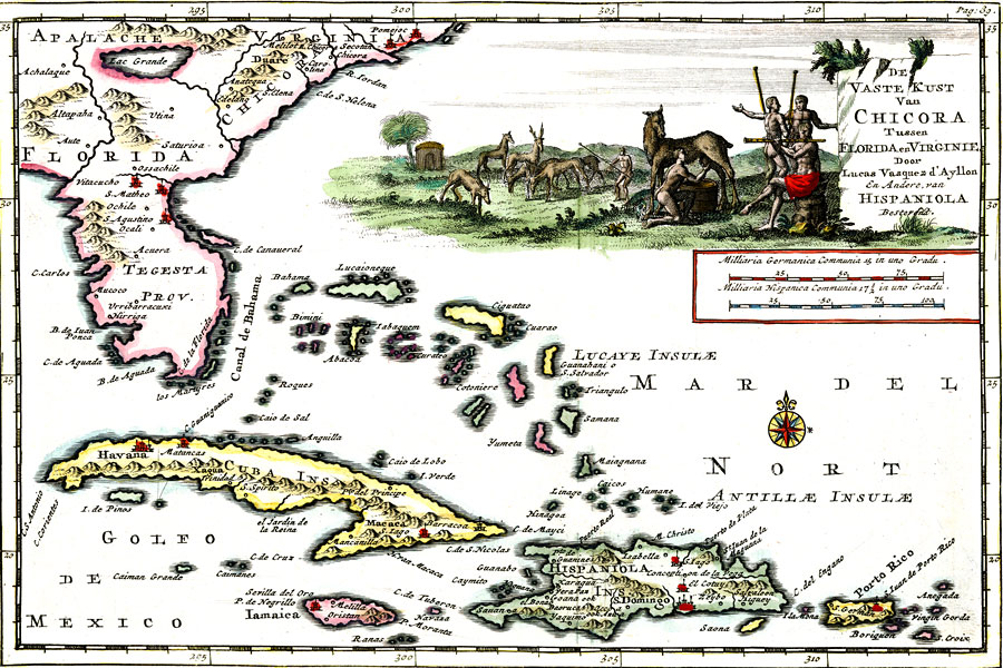
Florida Historical Maps
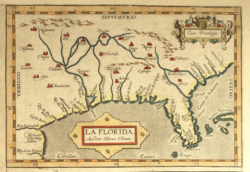
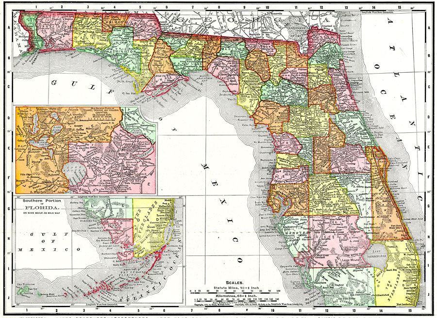
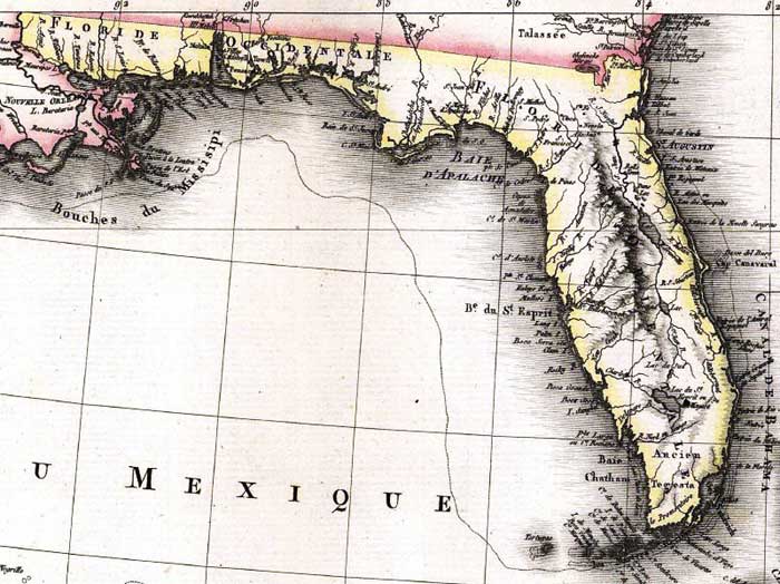
Florida’s historical maps provide a glimpse into the state’s rich past and the various events that shaped it. From the earliest known maps of the region created by European explorers to detailed maps of individual towns and cities, these historical maps offer valuable insight into Florida’s geography and history.
One of the earliest known maps of Florida is the 1564 map created by French explorer Jacques Le Moyne de Morgues. This map depicts the coastline of what is now Florida, including the St. Johns River and the Port Royal Sound. It also features depictions of Native American settlements, wildlife, and plants.
- To learn how 2D/3D historical maps are built, click here: USGS Historical Maps
- Florida Historical Maps-Library of Congress
- Florida Historical Maps-University of Florida Collections
- Florida Historical Maps-Florida State Historical Maps
In the 1700s, Florida was a battleground between European powers, with the Spanish and British vying for control. Many maps from this period depict Florida as a contested territory, with shifting boundaries and disputed claims. The 1763 “Plan of the Province of East Florida” shows the boundaries of the province as defined by the Treaty of Paris, which ended the French and Indian War.
During the American Civil War, Florida was a key battleground, with Union and Confederate forces fighting for control of the state’s ports and strategic locations. Many maps from this period depict the state’s topography and important landmarks, such as the forts at Pensacola and St. Augustine.
In the late 1800s and early 1900s, Florida experienced a tourism boom as visitors flocked to the state’s sunny beaches and warm climate. Many maps from this period depict popular tourist destinations, such as Miami Beach and Palm Beach, as well as the state’s growing transportation infrastructure, including railroads and highways.
The Library of Congress, the University of Florida, and the Florida State Archives all offer extensive collections of historical maps, ranging from the earliest depictions of the state to detailed maps of individual towns and cities. These maps provide a valuable window into Florida’s past and offer a unique perspective on the state’s development over time.
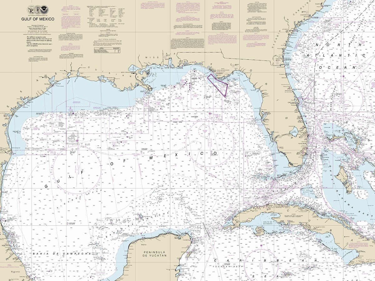
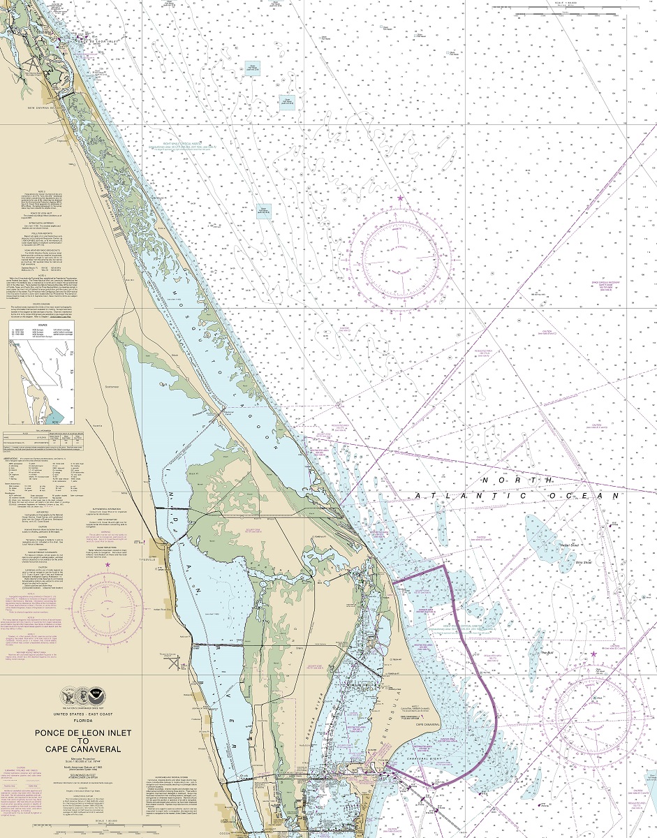
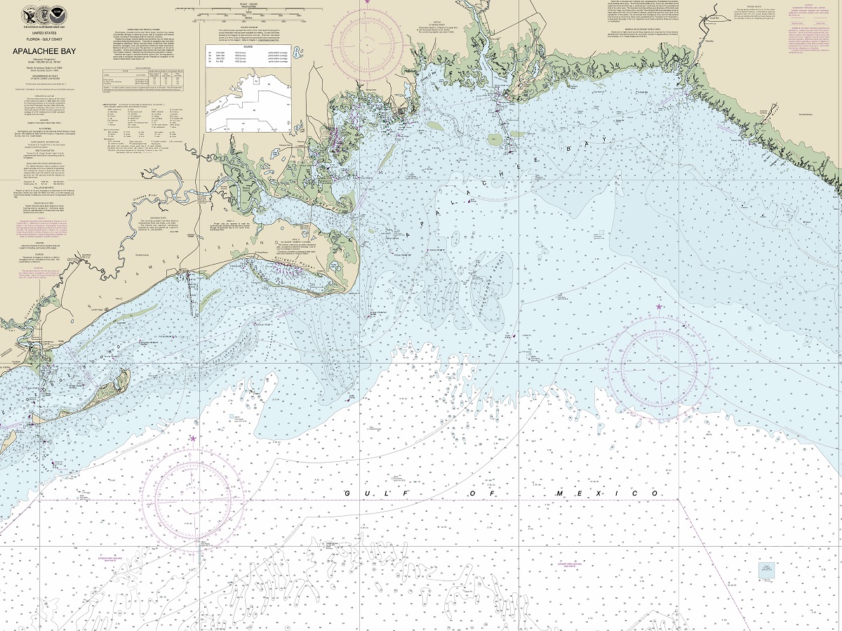
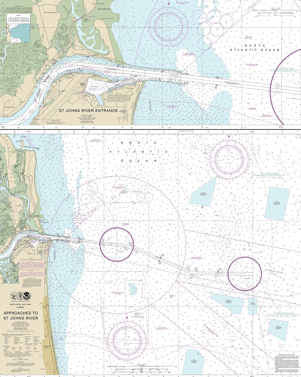
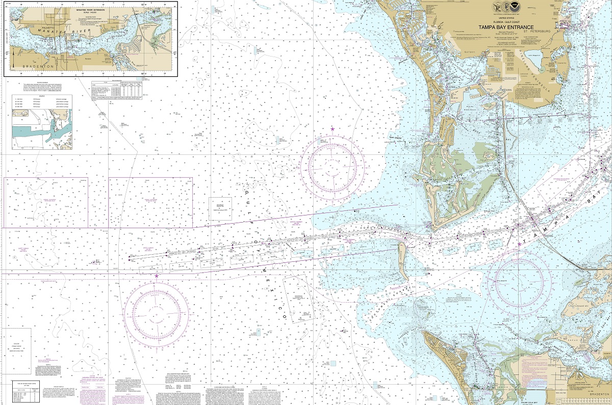
Florida Nautical Maps
Florida is a popular destination for boaters and fishermen alike, thanks to its extensive coastline, numerous lakes, and diverse marine ecosystems. For those planning to navigate these waters, Florida nautical maps can be an invaluable resource.
Nautical maps, also known as nautical charts, are maps specifically designed for use on the water. Unlike traditional land maps, nautical maps provide detailed information about water depths, underwater obstructions, and other hazards that can impact navigation. They also include information about tides, currents, and other important marine conditions.
- To learn how 2D/3D nautical maps are built, click here: Nautical Maps
- Florida Nautical Maps-Office of Coast Survey
- Florida Nautical Maps-Fish and Wildlife Office
- Florida Nautical Maps-NOAA Historical Chart Collection
Nautical maps are essential for boaters and fishermen who need to navigate unfamiliar waters safely. They can also be useful for coastal planning, marine resource management, and scientific research.
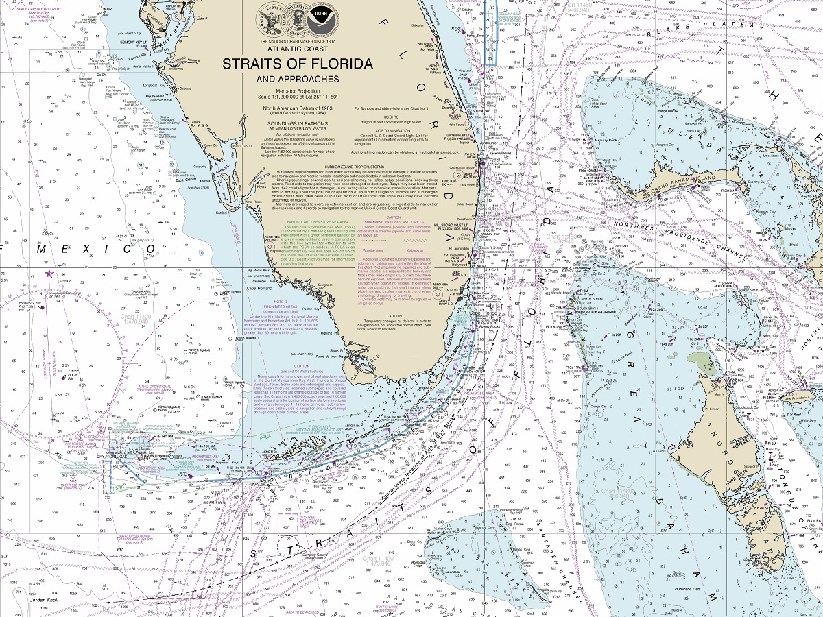
Nautical maps are particularly important for boaters and fishermen, as they can help to ensure safe navigation and prevent accidents on the water. By providing information about water depths, underwater obstructions, and other hazards, nautical maps can help boaters and fishermen avoid running aground, colliding with submerged objects, or other potential dangers.
In addition to safety concerns, nautical maps can also help boaters and fishermen locate fish and other marine life. By identifying areas with varying water depths, currents, and other conditions, nautical maps can help to identify optimal fishing spots and increase the chances of a successful catch.
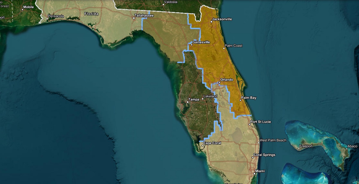
Florida Political Maps
Florida political maps provide a valuable resource for understanding the governmental boundaries of the state. Political maps show the physical boundaries of Florida’s counties, municipalities, and other governmental subdivisions. These maps provide an essential tool for analyzing data related to demographics, voting patterns, and other aspects of Florida’s political landscape.
- To learn how 2D/3D political maps are built, click here: Terrain Maps
- Florida Political Maps-Canvas Prints
- Florida Political Maps-Google Maps
- Florida Government Maps-Senate Districs
Political maps are maps that show the physical boundaries of governmental subdivisions, including counties, municipalities, and other administrative regions. These maps provide a visual representation of the distribution of governmental power within a specific geographic area . Political maps are useful for a variety of purposes, including analysis of voting patterns, demographic data, and other political factors.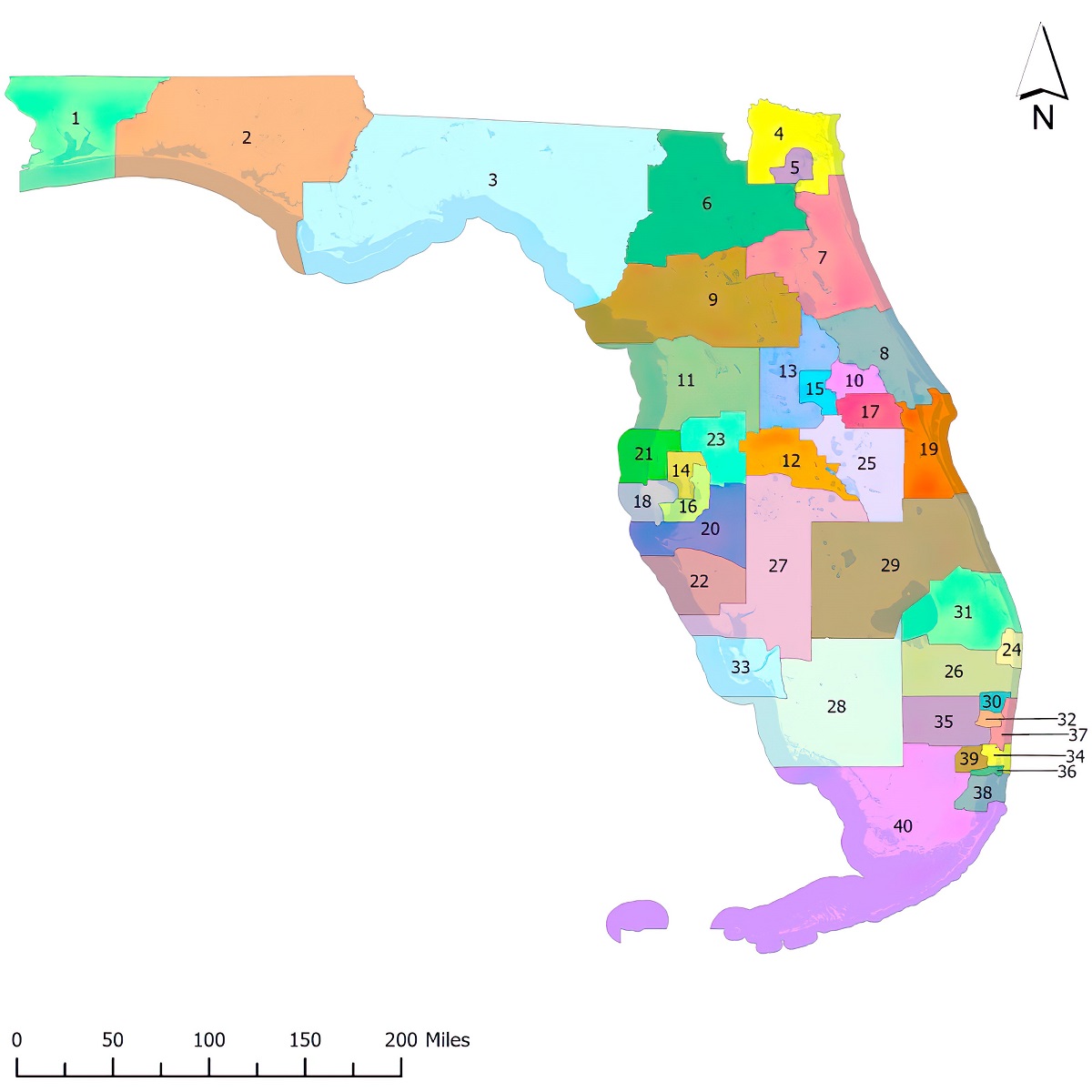
Political maps of Florida are important for understanding the state’s governmental boundaries. These maps provide a visual representation of the distribution of governmental power within the state, including the physical boundaries of counties, municipalities, and other administrative regions. By using political maps, analysts can better understand the distribution of political power and demographic data within different regions of the state.
Political maps of Florida are also important for analyzing voting patterns and other political data. By analyzing data from political maps, analysts can determine which regions of the state are most likely to support specific candidates or political parties. This information is essential for developing effective political strategies and targeting resources where they are most likely to have the greatest impact.
Florida Physical Maps
Florida physical maps provide a valuable resource for understanding the state’s natural features, including its coastline, rivers, lakes, and other physical characteristics. Physical maps are used to show the geography and topography of a region, including its mountains, valleys, plains, and other features.
Physical maps provide a visual representation of the natural characteristics of a region and are used for a variety of purposes, including geographic analysis, environmental research, and educational purposes.
- To learn how 2D/3D physical maps are built, click here: Physical Maps
- Florida Satellite Maps by Cities-Canvas Prints
- Florida Satellite Maps by Cities-3D Raised Relief
- Florida Physical Landforms Maps
- Florida Physical Maps-Google Maps
Physical maps of Florida are important for understanding the state’s natural features. These maps provide a visual representation of the state’s coastline, rivers, lakes, and other physical characteristics. By using physical maps, analysts can better understand the topography and geography of the state, which is essential for analyzing environmental data and developing effective strategies for managing natural resources.
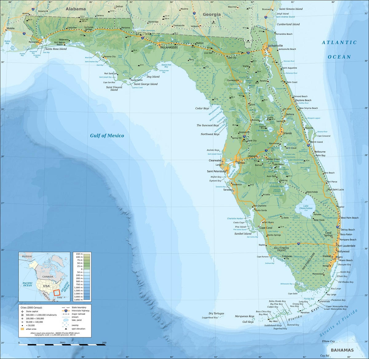
Physical maps of Florida are also important for understanding the impact of natural disasters, such as hurricanes, floods, and wildfires. By understanding the physical features of the state, emergency managers can better prepare for and respond to natural disasters, which can save lives and protect property.
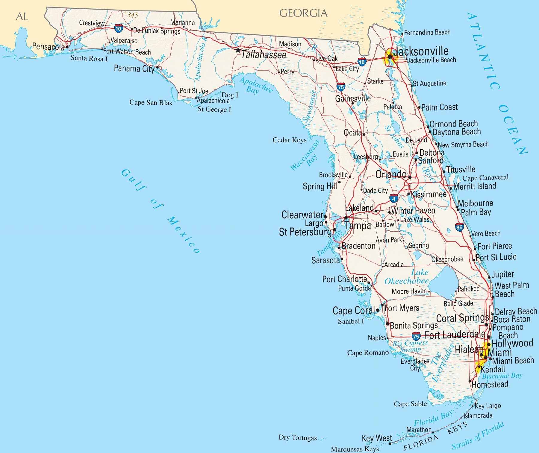
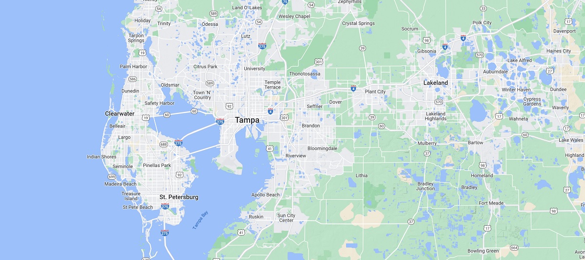
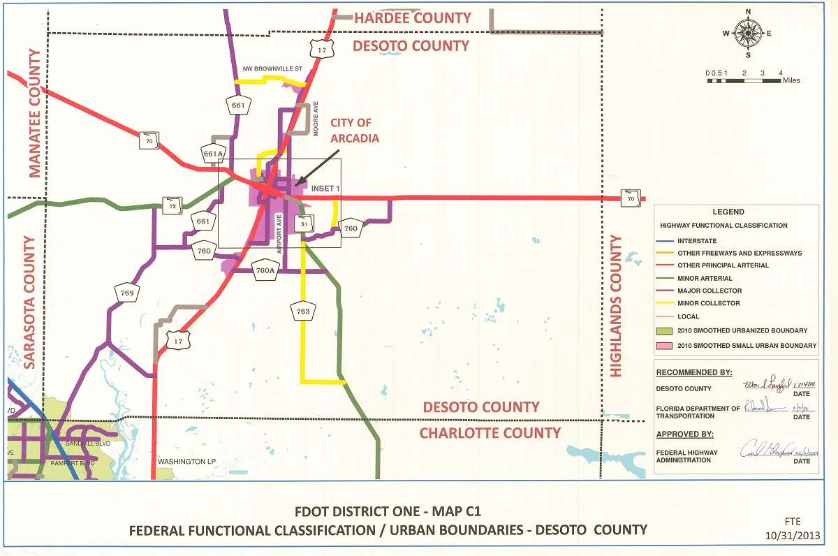
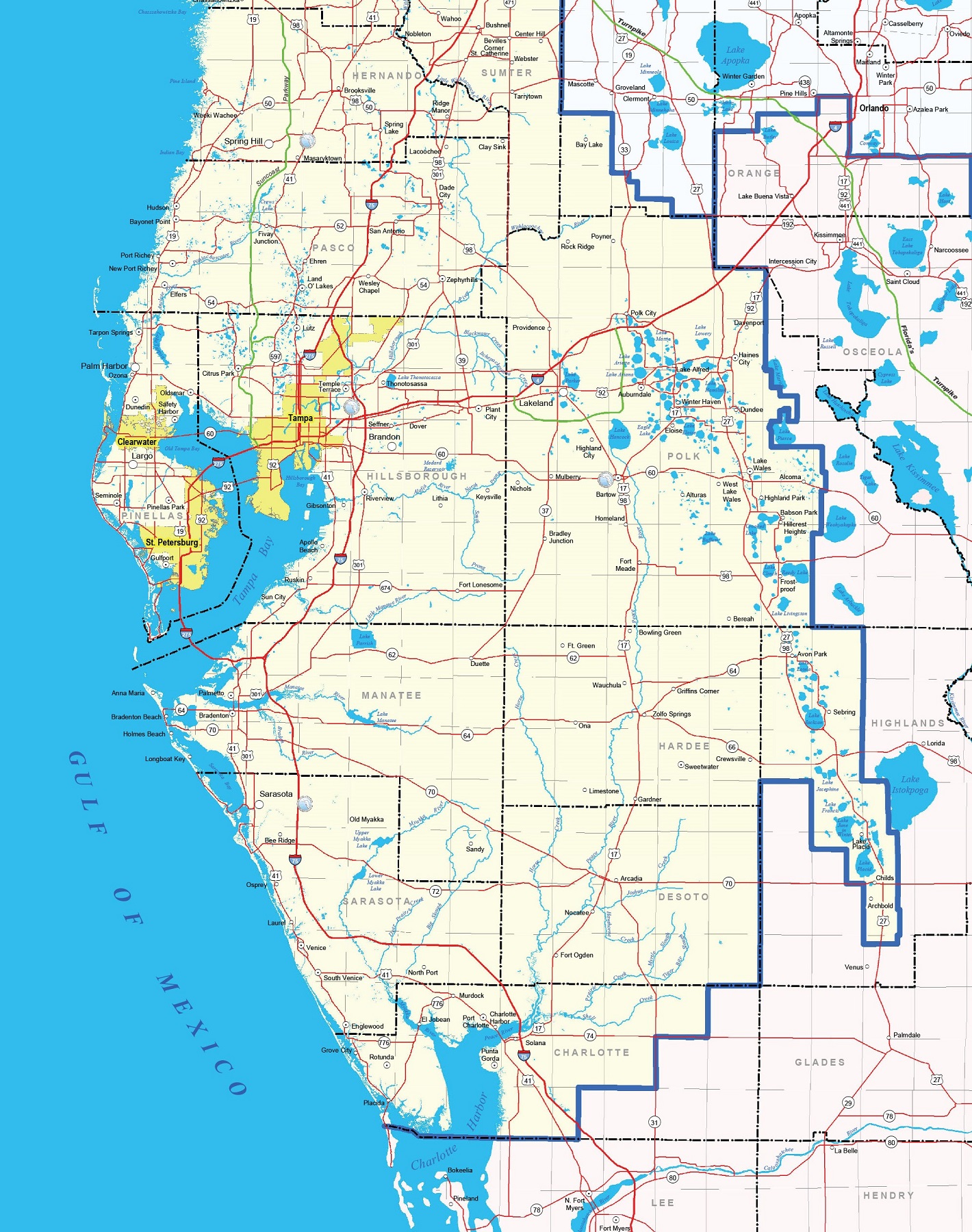
Florida Road Maps
Florida has a total land area of over 65,000 square miles. As one of the most populous states in the country, Florida has an extensive network of highways and roads that connect its various regions and cities. To help navigate this complex network, Florida road maps are an essential tool.
Road maps are a type of map that displays the roads and highways within a state or region, including their names, numbers, and intersections. In Florida, road maps can be used to plan travel routes, find alternate routes in case of traffic or construction, and locate attractions and landmarks along the way.
- To learn how 2D/3D road maps are built, click here: Terrain Maps
- Florida Road Maps-Canvas Prints
- Florida Road Maps-FDOT (Florida Department of Transportation)
- Florida Road Maps-FDOT Highway Classifications
- Florida Road Maps-Google Maps
One of the most popular areas of Florida for road mapping is the southern part of the state, which includes Miami-Dade, Broward, and Palm Beach counties. This region is known for its traffic congestion, so having a detailed road map can help drivers navigate the busy highways and streets. Road maps of this region can also be used to locate toll roads and expressways, which can save time and avoid traffic.
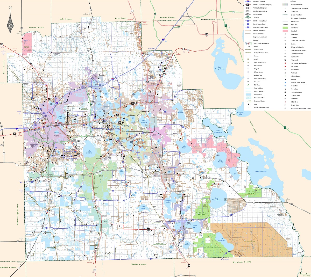
Another area of Florida that is popular for road mapping is the Panhandle region in the northwest part of the state. This area is known for its scenic drives, including the Gulf Coast Scenic Highway and the Big Bend Scenic Byway. Road maps of this region can be used to plan these drives, as well as to locate state parks, beaches, and other outdoor recreation areas.
Florida road maps can also be useful for planning road trips across the state or to other destinations in the Southeast. For example, maps of the Florida Keys can be used to plan a trip along the iconic Overseas Highway, which connects Key West to the mainland. Similarly, maps of the Interstate highway system can be used to plan trips to other states, such as Georgia, Alabama, or South Carolina.
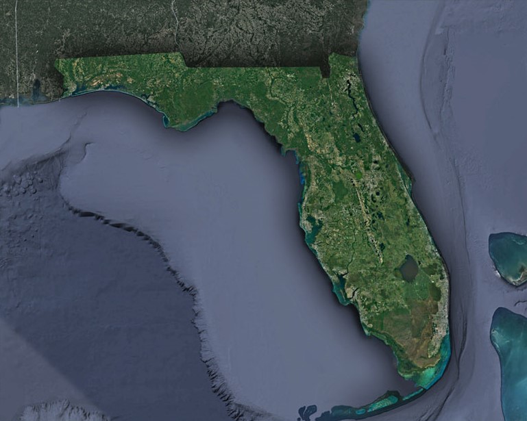
Florida Satellite Maps
Satellite maps of Florida are a useful tool for exploring and understanding the state’s geography. These maps provide detailed information about the state’s land, water, and natural resources. They can be used for a variety of purposes, including urban planning, environmental research, and natural disaster management.
- To learn how 2D/3D satellite maps are built, click here: Satellite Maps
- Florida Satellite Maps by Cities-Canvas Prints
- Florida Satellite Maps by Cities-3D Raised Relief
- Florida Satellite Maps-Google Maps
One of the most important features of Florida satellite maps is their ability to show the state’s coastline. With over 1,300 miles of coastline, Florida has some of the most beautiful beaches in the world. Satellite maps can show the location of beaches, as well as the type of beach and its surrounding environment. This information is useful for tourism and coastal management, as well as for understanding the state’s unique ecology.
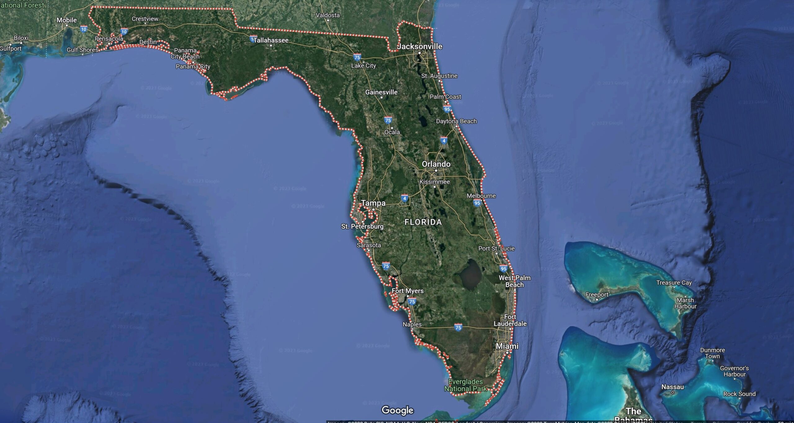
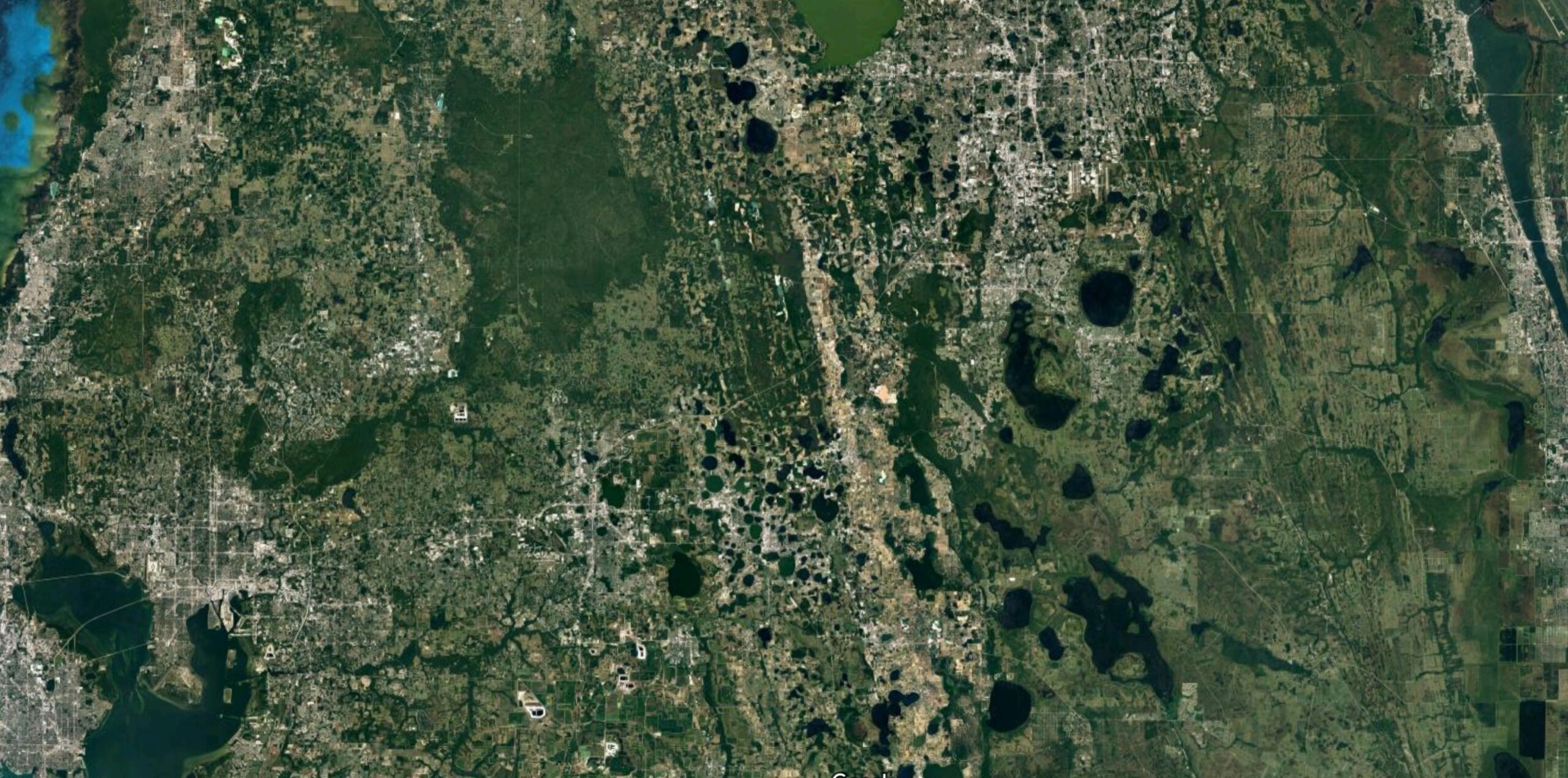
Satellite maps can also provide valuable information about Florida’s rivers and lakes. The state is home to numerous rivers and lakes, including the St. Johns River, Lake Okeechobee, and the Everglades. These bodies of water are important for fishing, recreation, and water management. Satellite maps can show the location, size, and shape of these bodies of water, as well as the surrounding land use and development.
Another important use of satellite maps in Florida is for urban planning and development. The state’s major cities, including Miami, Orlando, and Tampa, have experienced significant growth in recent years. Satellite maps can provide detailed information about land use, transportation networks, and urban development patterns. This information is useful for city planners, developers, and policymakers, as well as for understanding the social and economic dynamics of urban areas.
Satellite maps can also provide valuable information about natural resources in Florida, including forests, wetlands, and wildlife habitats. The state is home to numerous protected areas, including national parks, wildlife refuges, and state forests. Satellite maps can show the location, size, and type of these areas, as well as the surrounding land use and development. This information is useful for conservation and environmental management, as well as for understanding the state’s natural beauty and biodiversity.
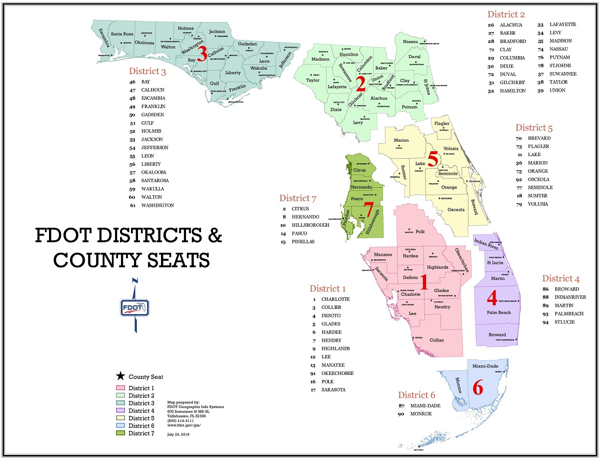
Florida State Maps
Florida is known for its sunny weather, beautiful beaches, and diverse geography. To explore and navigate this state, Florida state maps are an essential tool.
Florida state maps provide a detailed overview of the state’s geography, including its cities, highways, landmarks, and natural features. They are created and maintained by various government agencies, including the Florida Department of Transportation (FDOT) and the Florida Geographic Information System (FGIS).
One of the primary applications of Florida state maps is in navigation. With over 21 million residents and millions of tourists visiting each year, Florida can be a crowded and confusing place to drive. State maps can provide information on highways, roads, and major intersections, allowing drivers to plan their routes and avoid traffic.
- To learn how 2D/3D state maps are built, click here: Satellite Maps or Terrain Maps
- FDOT State Maps
- FGIS State Maps
- Florida Satellite Maps by Cities-Canvas Prints
- Florida Satellite Maps by Cities-3D Raised Relief
- Florida State Maps-Google Maps
If you are a fan of traditional paper maps, many travel guides and tourist centers in Florida offer free maps of the state’s cities. These maps are usually easy to read and provide a comprehensive overview of the city, including major points of interest, parks, and other landmarks. They may also include helpful information like public transportation routes and parking options.
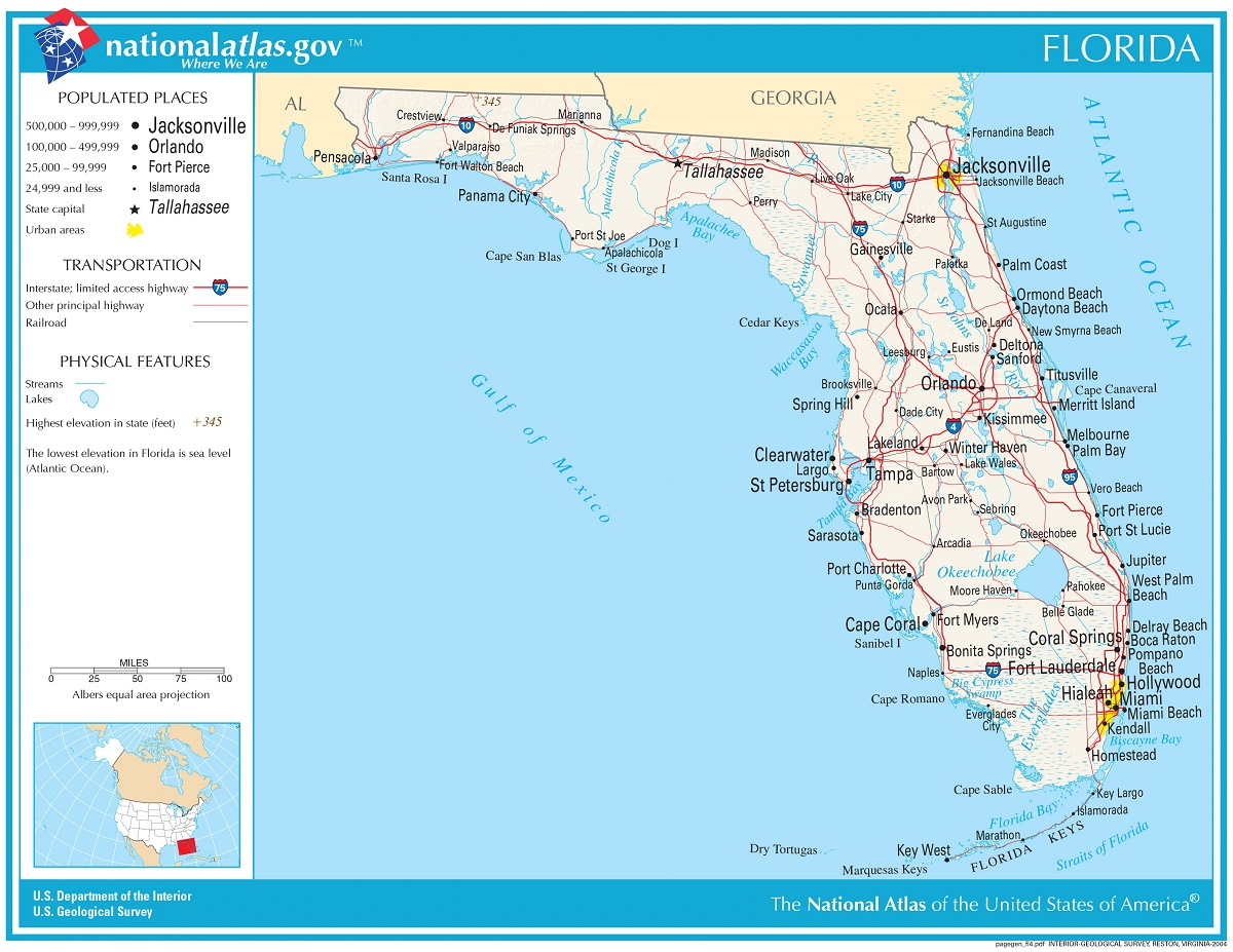
Florida state maps are also useful in exploring the state’s many landmarks and natural attractions. From the Florida Keys to the Everglades to the Space Coast, Florida is home to a wealth of unique and exciting destinations. State maps can provide information on parks, beaches, museums, and other attractions, helping visitors plan their trips and make the most of their time in the state.
Another important application of Florida state maps is in emergency management. Florida is vulnerable to a variety of natural disasters, including hurricanes, flooding, and wildfires. State maps can provide information on evacuation routes, emergency shelters, and other resources, helping residents and emergency responders prepare and respond to disasters effectively.
Florida state maps are also useful in urban planning and economic development. They can provide information on population density, land use, and other demographic factors, helping planners and policymakers make informed decisions about zoning, transportation, and economic development.
Florida Terrain Maps
Florida is known for its tropical climate, beautiful beaches, and unique wildlife. Florida is also home to a diverse terrain. From its flat, sandy coastal plains to its swampy, marshy wetlands, the state’s terrain is as varied as it is beautiful.
One of the best ways to explore Florida’s terrain is through the use of maps. Terrain maps provide detailed information about the landscape, including elevation, water features, and vegetation.
- To learn how 2D/3D terrain maps are built, click here: Terrain Maps
- Florida Terrain Maps by Cities-Canvas Prints
- Florida Terrain Maps by Cities-3D Raised Relief
- Florida Terrain Maps-Google Maps
Topographic maps are perhaps the most common type of terrain map. They use contour lines to represent changes in elevation, providing a three-dimensional view of the landscape. These maps are particularly useful for hikers and outdoor enthusiasts, as they show the location of trails, rivers, and other landmarks.
Geologic maps show the types and ages of rocks and sediments that make up the terrain. They also provide information about faults, folds, and other geological features that can affect the landscape.
These maps are particularly useful for scientists and researchers who are interested in understanding the geological history of Florida. They can also be helpful for anyone who wants to learn more about the rocks and sediments that make up the state’s terrain.
Land cover maps show the types of vegetation and land use in an area. They can be used to identify areas of natural habitat, as well as areas that have been developed for human use.
These maps can be useful for anyone who wants to understand the impact of human activity on Florida’s terrain. They can also be helpful for conservationists who are working to protect natural habitats and wildlife.
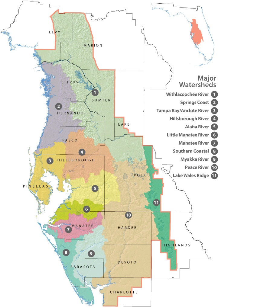
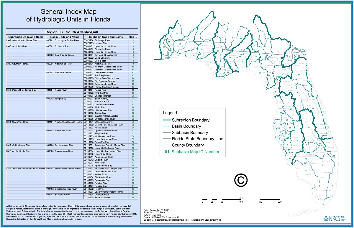
Florida Watershed Maps
Florida is home to an abundance of water resources. From lakes, rivers, and springs to wetlands and coastal estuaries, the state is rich in biodiversity and natural beauty. However, this natural wealth is at risk due to threats such as pollution, climate change, and land-use changes. That’s why understanding the state’s watershed maps is crucial in protecting and conserving these valuable resources.
A watershed is an area of land where all the water that falls within its boundaries eventually flows to a common point, such as a river, lake, or ocean. Florida has six major watersheds: the Apalachicola-Chattahoochee-Flint (ACF) river system, the Suwannee River, the St. Marys River, the St. Johns River, the Peace River, and the Kissimmee River. These watersheds are further divided into sub-watersheds and basins, creating a complex network of interconnected waterways.
- To learn how 2D/3D watershed maps are built, click here: Watershed Maps
- Northwest Florida Water Distric Watershed Maps
- Suwannee River Water District Watershed Maps
- St. Johns River Water District Watershed Maps
- Southwest Florida Water District Watershed Maps
- South Florida Water District Watershed Maps
Watershed maps are essential tools for understanding the location and extent of these water resources. They help identify areas where pollution and other environmental stressors may be affecting water quality and quantity. These maps also play a crucial role in developing effective management strategies that balance the competing demands of human uses and environmental protection.
Florida’s watershed maps are developed and maintained by various government agencies, including the Florida Department of Environmental Protection (FDEP), the South Florida Water Management District (SFWMD), and the St. Johns River Water Management District (SJRWMD). These agencies use advanced geographic information systems (GIS) and remote sensing technologies to gather data on land use, vegetation, soils, topography, and hydrology to create these maps.
One of the most critical applications of watershed maps is in identifying and managing non-point source pollution. This type of pollution comes from diffuse sources such as agricultural runoff, stormwater runoff, and urban runoff, making it difficult to pinpoint the source of the pollution. Watershed maps can help identify areas where non-point source pollution may be affecting water quality and guide management practices that reduce these impacts.
Watershed maps are also crucial in protecting and managing wetlands, which play a vital role in filtering pollutants and protecting downstream water quality. These maps can help identify areas where wetlands are at risk of degradation, allowing for targeted restoration and protection efforts.
Another important application of watershed maps is in developing effective water resource management plans. These plans help balance the competing demands of water users, including agriculture, industry, municipalities, and the environment. By understanding the location and extent of water resources, stakeholders can make informed decisions about water use and management.
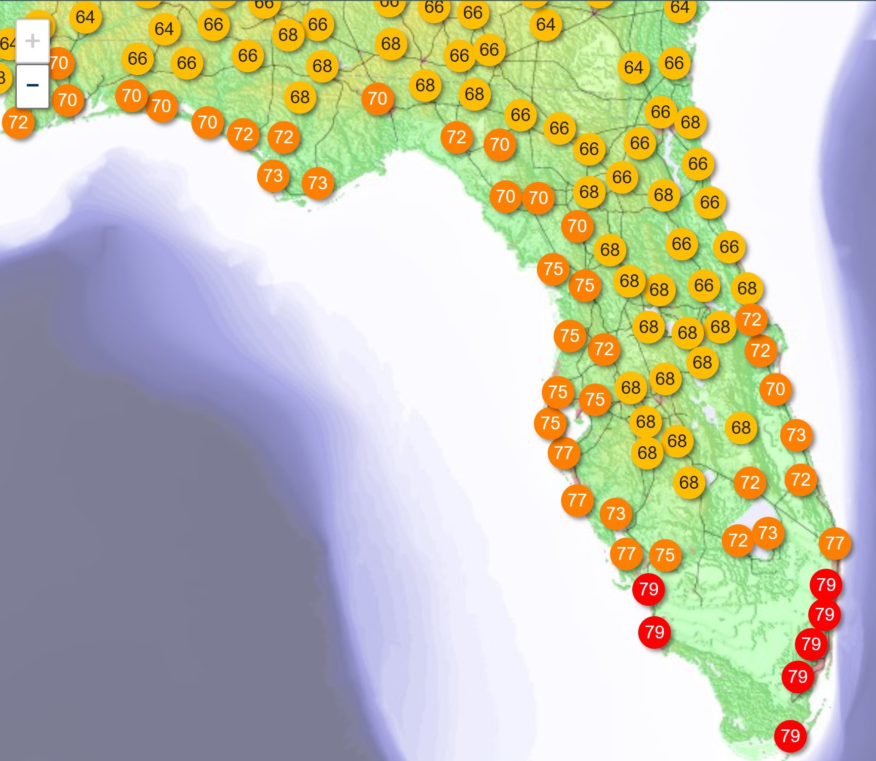
Florida Weather Maps
Florida, known for its sunny weather, is a state that is vulnerable to extreme weather conditions such as hurricanes, tropical storms, and flooding. To better understand and prepare for these weather events, Florida weather maps are an essential tool.
Florida weather maps provide up-to-date information on current and future weather conditions, including temperature, precipitation, wind speed and direction, and storm tracking. These maps are created and maintained by various government agencies, including the National Weather Service (NWS) and the National Oceanic and Atmospheric Administration (NOAA).
- To learn how 2D/3D weather maps are built, click here: NOAA Maps
- Florida Current Radar Weather Maps
- Florida National Weather Service Forecast Maps
- Florida Accuweather Maps
- Florida CapeWeather Maps
- Florida Weather Forecast Maps
One of the most critical applications of Florida weather maps is in preparing for hurricanes and tropical storms. These maps can provide early warning of approaching storms, allowing residents to take necessary precautions to protect themselves and their property. They can also provide information on storm tracks, intensity, and potential impacts, allowing emergency responders to prepare and respond effectively.
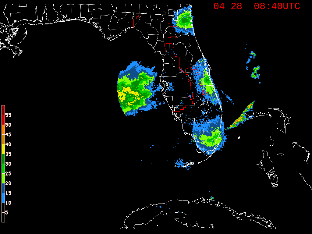
Florida weather maps are also essential in managing flood risks. Florida is prone to flooding, especially in low-lying areas and coastal regions. Floodplain maps, which are a type of weather map, can identify areas that are at risk of flooding, allowing for the development of flood mitigation strategies and emergency management plans.
Another important application of Florida weather maps is in managing water resources. Florida’s economy and environment are dependent on a reliable and sustainable supply of water. Weather maps can provide information on rainfall patterns and water availability, helping water managers make informed decisions about water allocation and conservation.
Florida weather maps are also useful in agriculture, helping farmers to make decisions about planting, harvesting, and irrigation. They can provide information on soil moisture, temperature, and other weather conditions, helping farmers to optimize crop yields and minimize risks from weather-related events.
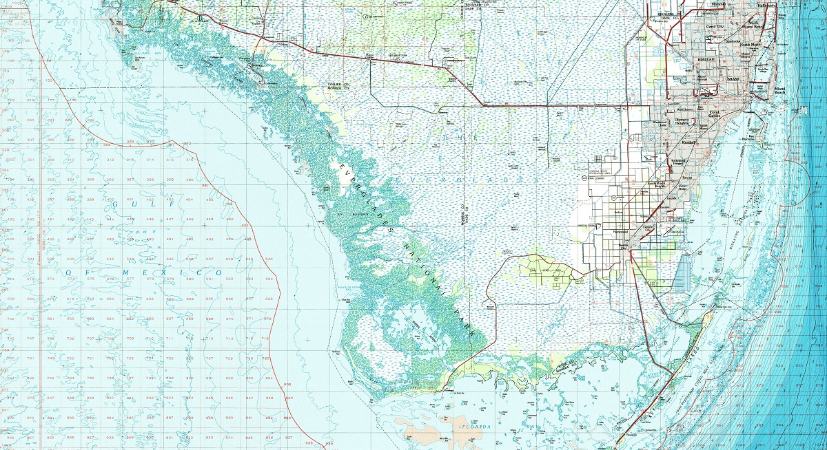
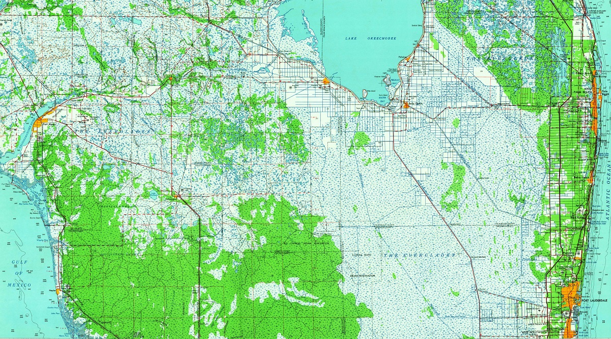
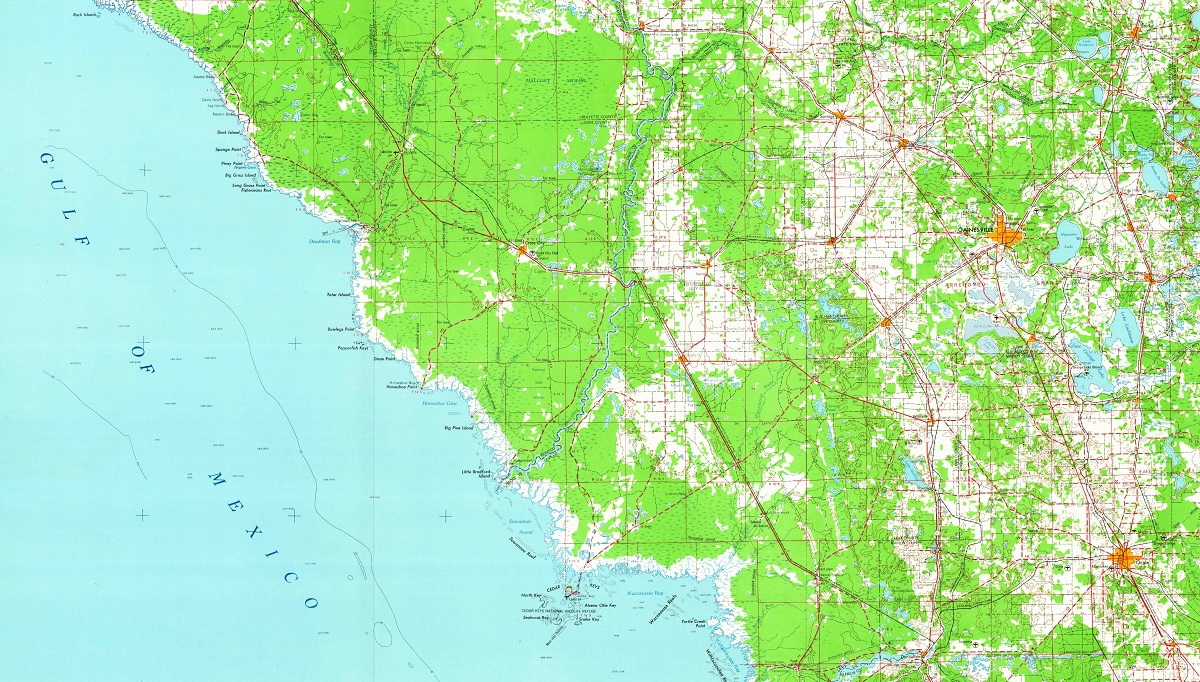
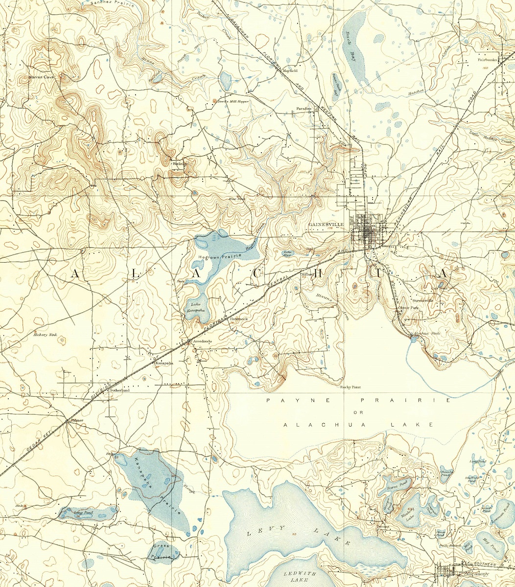
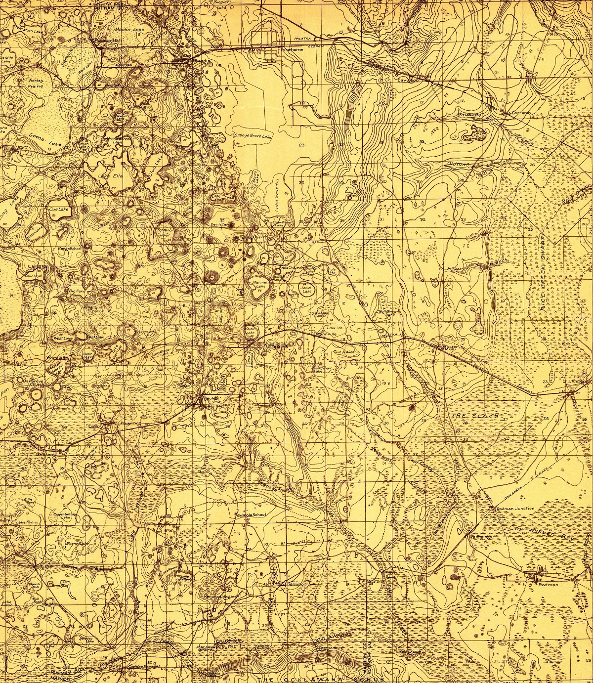
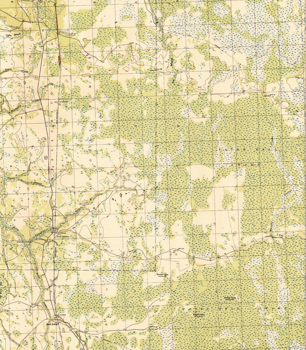
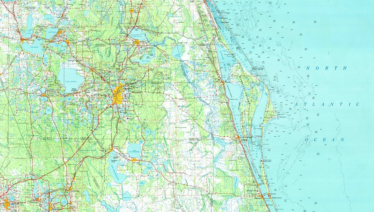
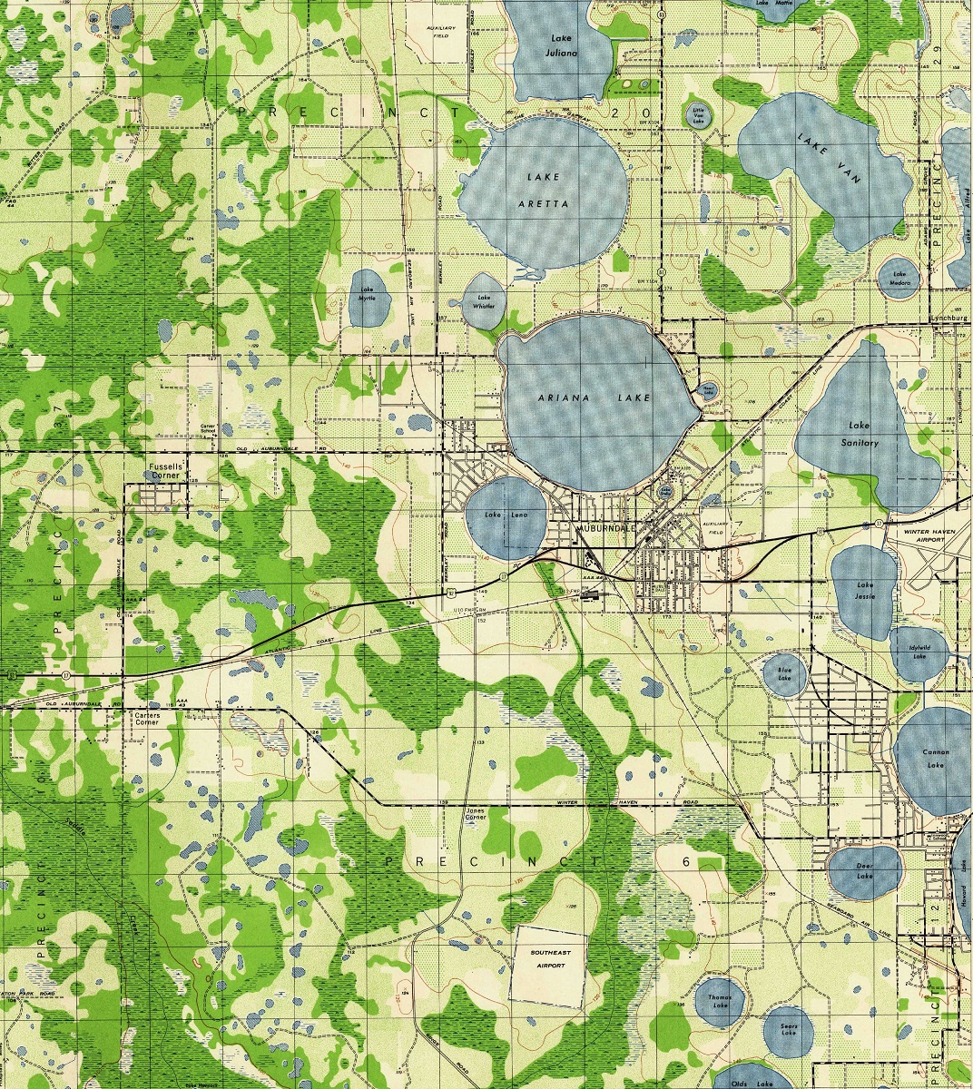
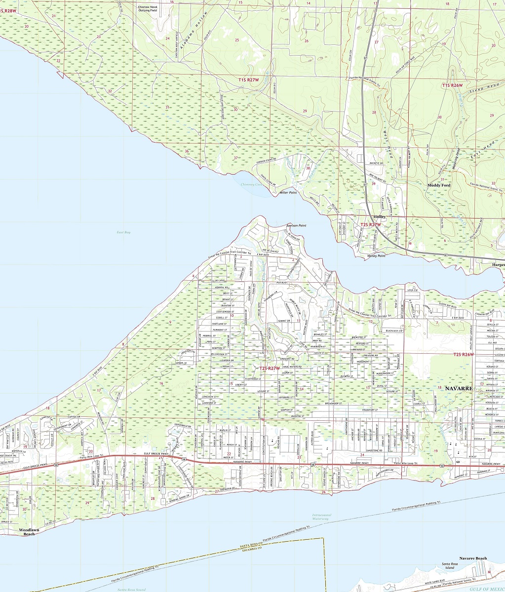
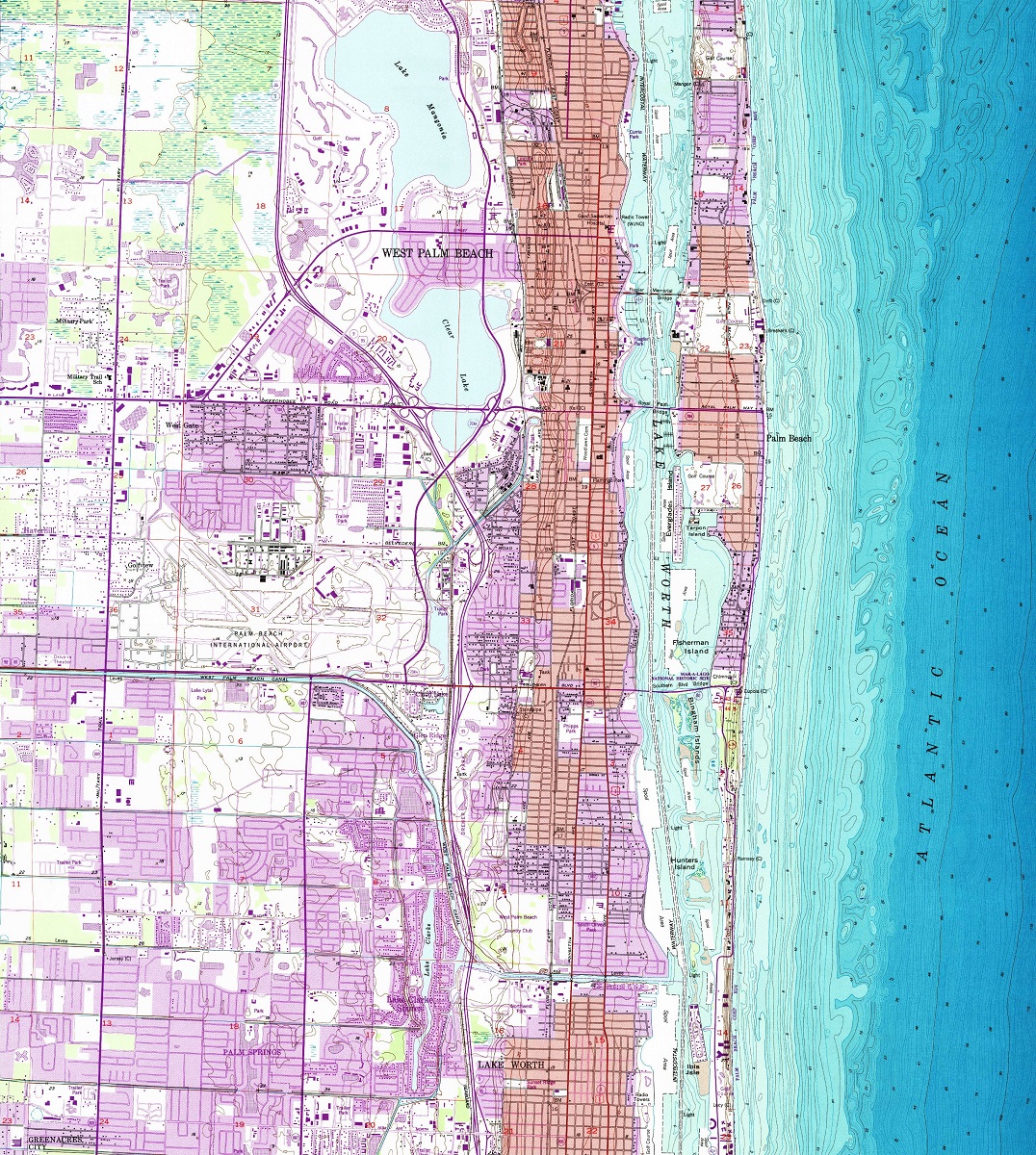
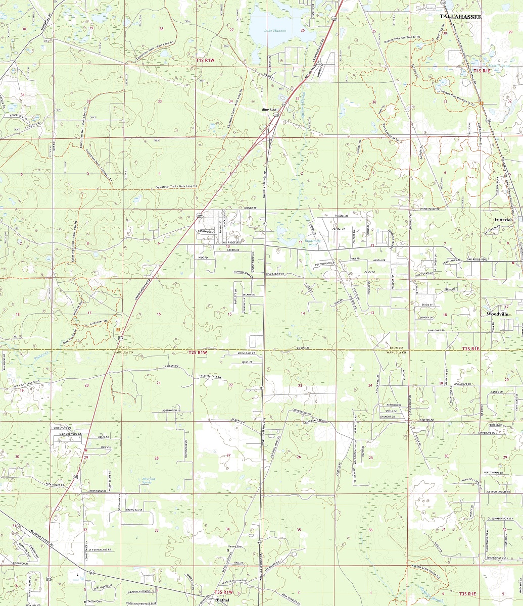
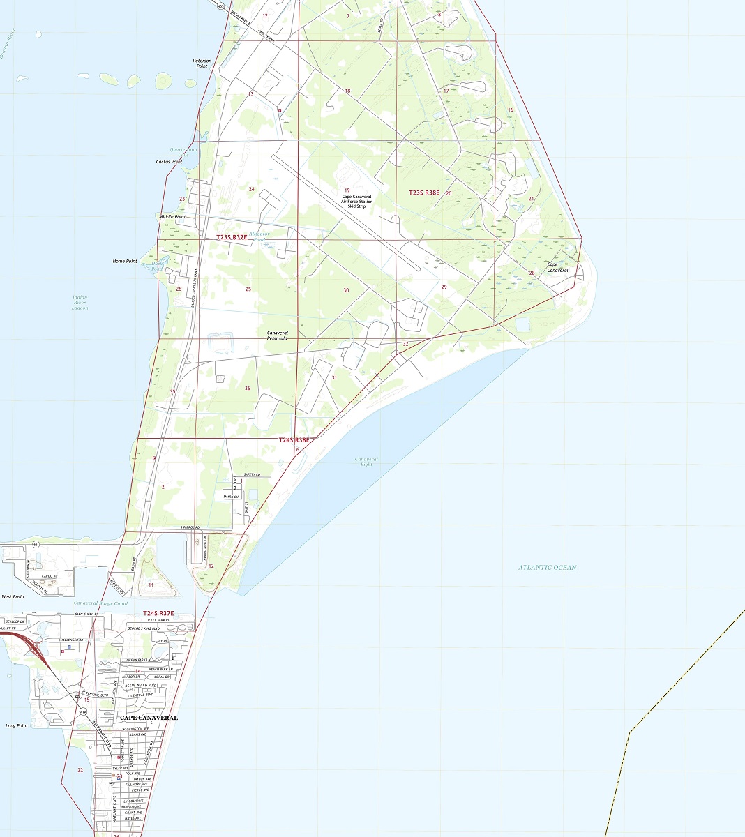
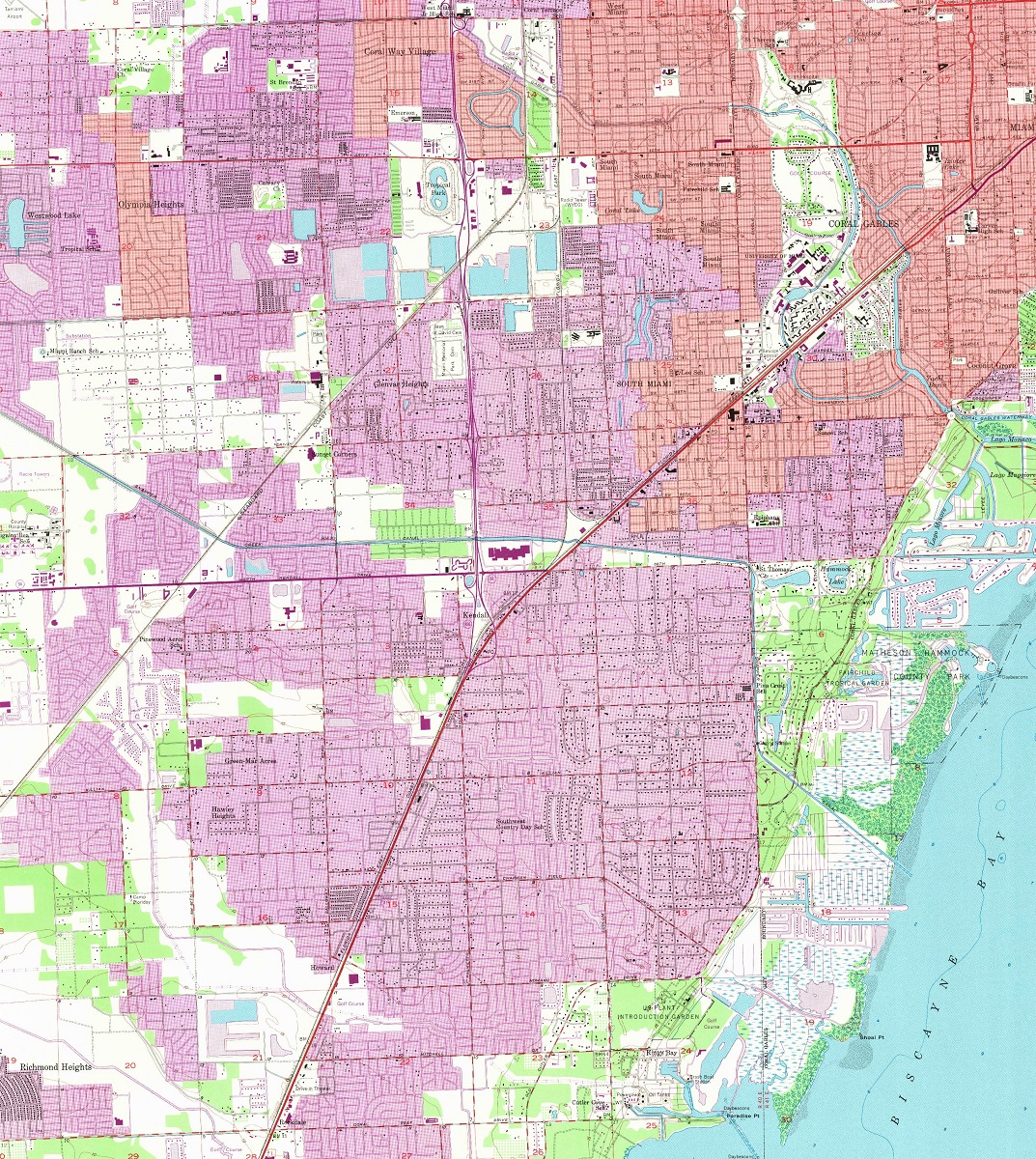
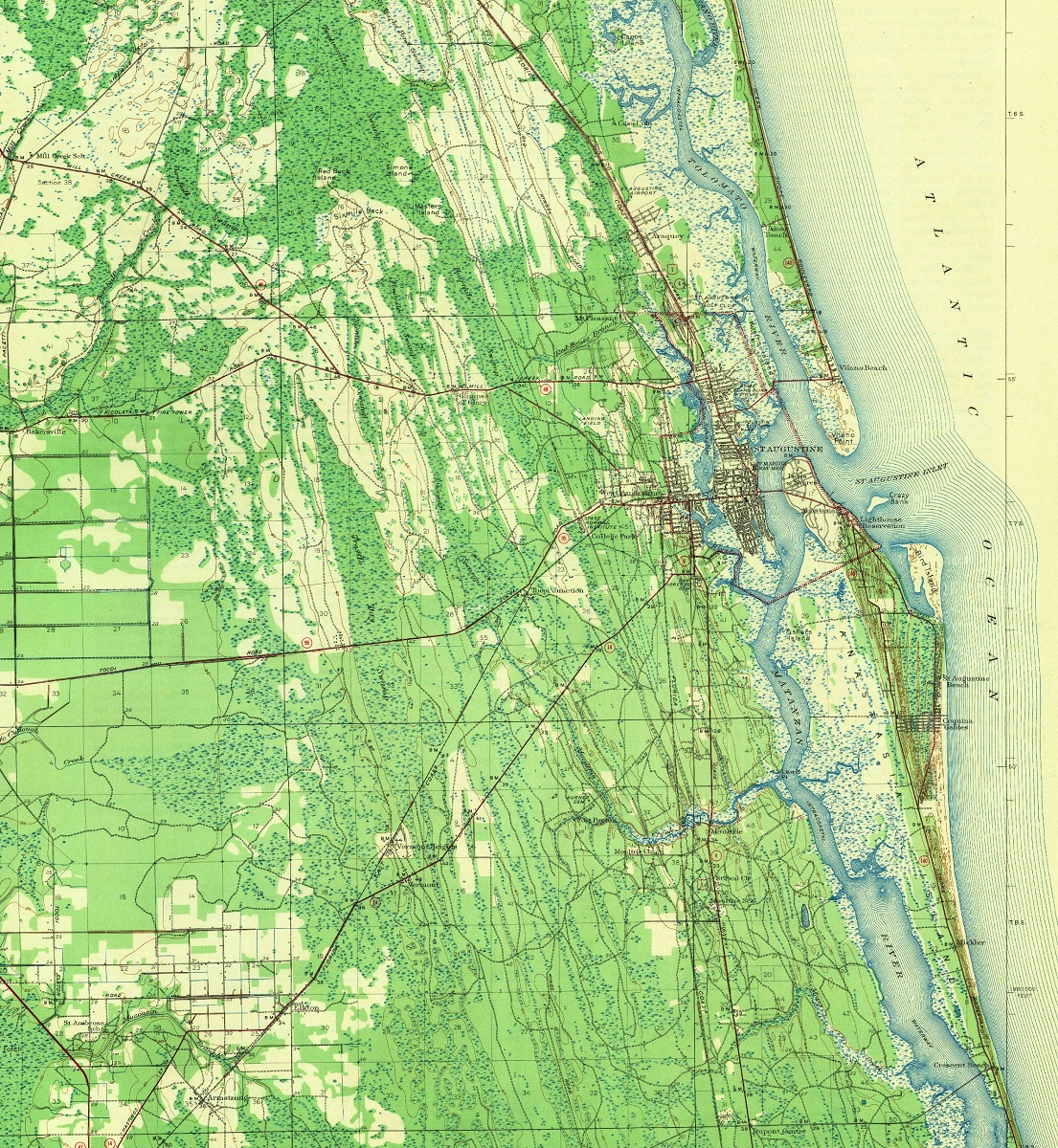
Florida USGS Maps
The United States Geological Survey (USGS) produces topographic maps of Florida that provide detailed information on the state’s geography, including its elevations, landforms, and hydrography. These maps are an essential tool for a range of applications, from recreational activities to scientific research.
USGS maps of Florida are divided into quadrangles, each covering an area of 7.5 minutes of longitude and latitude. Each map provides detailed information on topography, including elevation contours, water features, and vegetation types. The maps also include roads, buildings, and other landmarks, allowing users to navigate and explore the landscape with precision.
- To learn how 2D/3D USGS maps are built, click here: USGS Maps and USGS Historical Maps
- Florida USGS Topo Maps by Cities-Canvas Prints
- Florida USGS Historical Topo Maps by Cities-Canvas Prints
- Florida USGS Topo 3D Maps by Cities-3D Raised Relief
- Florida USGS Historical Topo 3D Maps by Cities-3D Raised Relief
Historical USGS maps of Florida are also available and provide a fascinating glimpse into the state’s past. These maps were produced using traditional cartographic techniques, including photolithography and offset printing.
Historical USGS maps of Florida are valuable for a range of applications, including historical research, environmental assessment, and land use planning. They can provide information on changes in land use, including deforestation, urbanization, and agricultural development. They can also provide information on the natural features of the landscape, including wetlands, rivers, and other water bodies.


