

The state of Florida is known for its pristine beaches, sunny weather, and vibrant culture. However, what many people don’t realize is that there is so much more to this state than meets the eye. Florida is home to a diverse range of landscapes, from the rolling hills and mountains of the north to the subtropical wetlands of the south. And what better way to explore these landscapes than through maps of Florida?
In this blog post, we will take a deep dive into the various types of maps of Florida and uncover the mysteries of the Sunshine State.
Bathymetric Maps
Let’s start with bathymetric maps, which show the depths and contours of the ocean floor. Florida is home to some of the most beautiful and diverse marine ecosystems in the world, including the Florida Keys National Marine Sanctuary, which spans 2,900 square nautical miles. Bathymetric maps can help us understand the unique features of these ecosystems and the impact of human activity on them.
Contour Maps
Contour maps show the shape and elevation of the land surface, providing us with a three-dimensional view of Florida’s terrain. These maps are especially useful for hikers, climbers, and outdoor adventurers looking to explore Florida’s natural beauty. With contour maps, you can plan your next hiking trip or rock-climbing expedition with ease.
County Maps
County maps are useful for navigating Florida’s cities and towns, as they show the boundaries of each county and the major roads and highways within them. These maps can help you find your way around Florida’s vibrant cities, from Miami to Tampa to Jacksonville.
Elevation Maps
Elevation maps show the height of the land surface relative to sea level. Florida’s elevation ranges from sea level at its coastal regions to over 300 feet above sea level in the north-central part of the state. Elevation maps can help us understand the impact of weather patterns on Florida’s landscape, as well as the potential for flooding and other natural hazards.
Geologic Maps
Geologic maps show the distribution of rocks, minerals, and other geologic features across a given area. Florida’s geology is unique, as much of the state is composed of limestone, which is susceptible to sinkholes and other geological hazards. Geologic maps can help us understand these hazards and how they affect Florida’s landscape.
Historical Maps
Historical maps provide a fascinating glimpse into Florida’s past, showing how the state has changed over time. From the first European settlements in the 16th century to the boom of the 20th century, Florida’s history is rich and varied. Historical maps can help us understand this history and how it has shaped the state we know today.
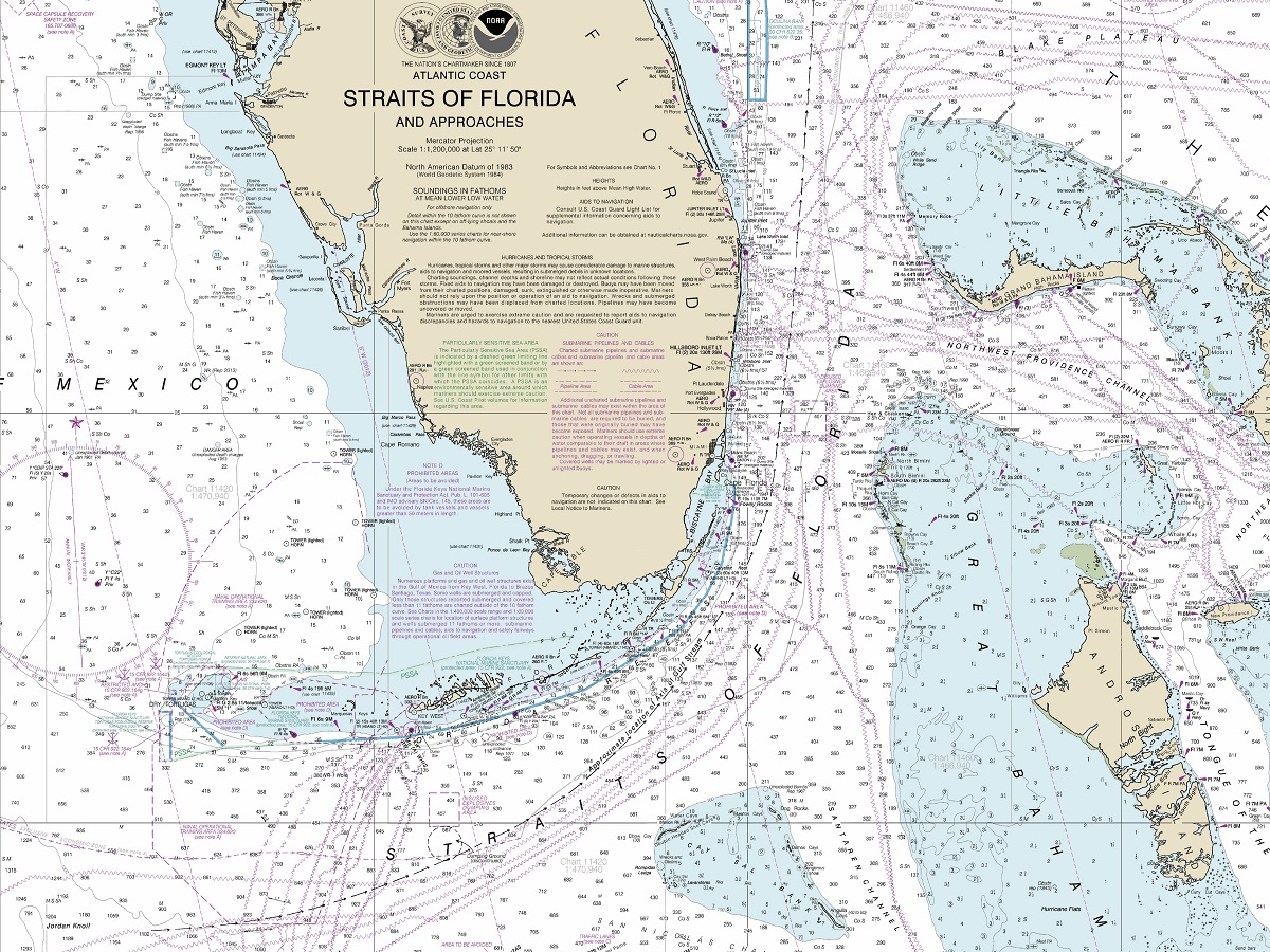
Nautical Maps
Nautical maps are essential for navigating Florida’s vast waterways, from the Gulf of Mexico to the Atlantic Ocean to the many rivers and lakes that crisscross the state. These maps show the location of navigation aids, such as buoys and lighthouses, as well as the depths of water and potential hazards.
Road Maps
Road maps are a staple of modern navigation, providing us with a detailed view of Florida’s highways and byways. Whether you’re planning a road trip across the state or just need to find your way to a new destination, road maps are an essential tool for any traveler.
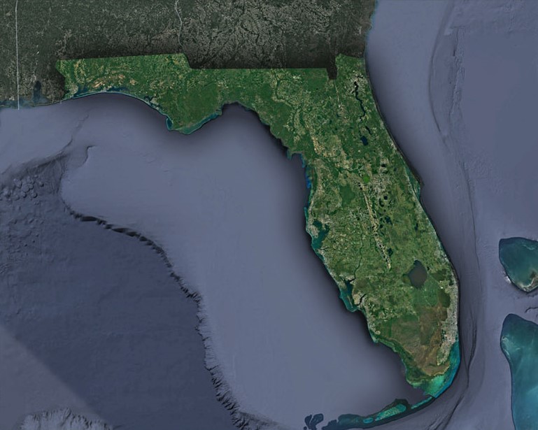
Satellite Maps
Satellite maps provide us with a bird’s-eye view of Florida’s terrain, showing the land surface in incredible detail. These maps are especially useful for scientists and researchers studying Florida’s environment, as they can help identify patterns and changes over time.
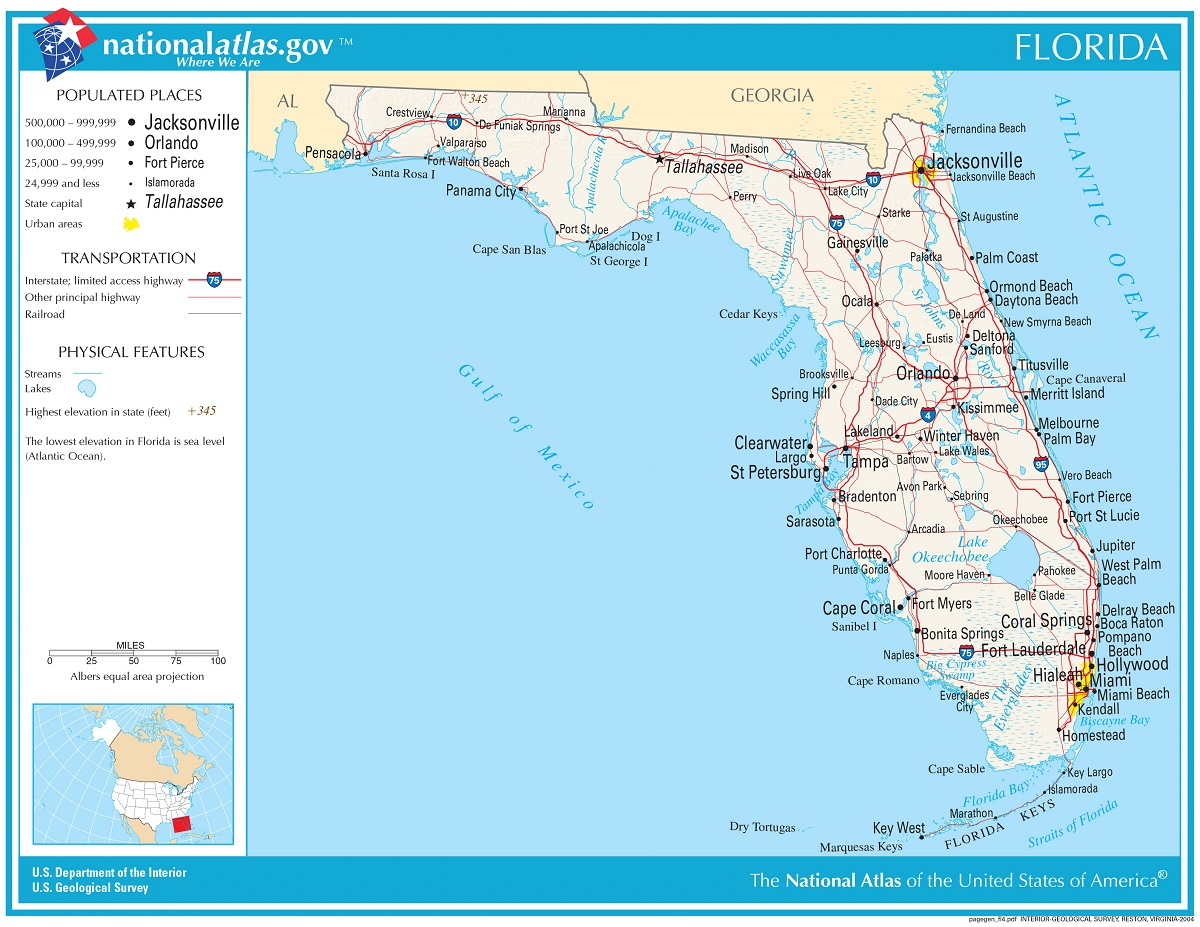
State Maps
State maps provide a general overview of Florida’s geography, including its major cities, rivers, and other landmarks. These maps are useful for anyone looking to explore Florida’s natural beauty or plan a trip to the state.
Terrain Maps
Terrain maps show the physical features of Florida’s landscape, including mountains, hills, valleys, and other landforms. These maps are useful for hikers and outdoor adventurers looking to explore Florida’s natural beauty and plan their next adventure.
Topographical Maps
Topographical maps provide a detailed view of the land surface, including elevation, contour lines, and other physical features. These maps are useful for anyone looking to explore Florida’s natural beauty, as they can help identify the best trails, peaks, and other features.
USGS Maps
USGS maps are produced by the United States Geological Survey and provide a detailed view of the land surface, including geology, topography, and other features. These maps are useful for anyone looking to explore Florida’s natural beauty and understand its geology and other physical features.
Watershed Maps
Watershed maps show the boundaries of watersheds and the direction that water flows across Florida’s landscape. These maps are useful for anyone interested in water management, as they can help identify potential sources of pollution and other environmental hazards.
Weather Maps
Weather maps provide a detailed view of Florida’s weather patterns, including temperature, precipitation, and other factors. These maps are useful for anyone planning an outdoor adventure or interested in Florida’s climate and weather patterns.
Maps of Florida are an essential tool for exploring and understanding Florida’s unique landscape. Whether you’re a hiker, outdoor adventurer, scientist, or simply a curious traveler, maps can help you unlock the mysteries of the Sunshine State and uncover its hidden beauty. So, the next time you’re planning a trip to Florida, don’t forget to bring your map and explore everything this beautiful state has to offer.

Maps of Florida
To learn more in-depth about 2D and 3D Florida maps, view Florida Maps.