

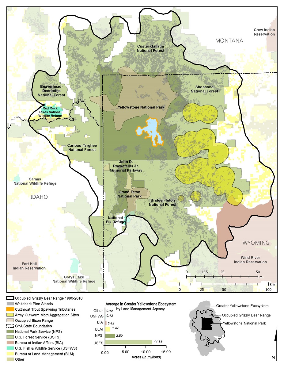
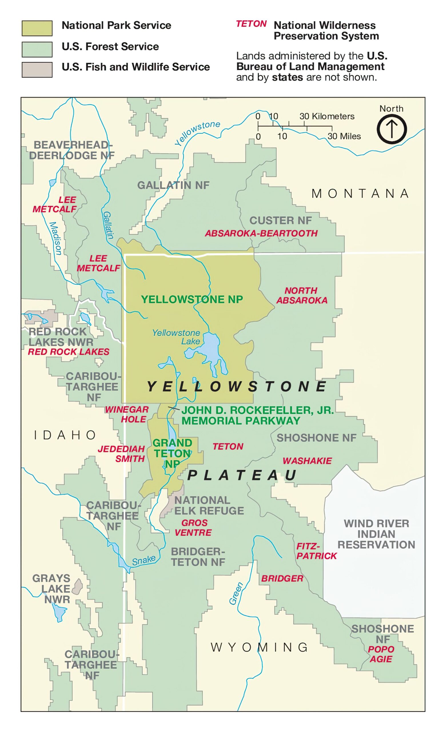
Yellowstone National Park is a wonderland of natural beauty, spanning over 2.2 million acres of breathtaking landscape in the western United States. From its awe-inspiring geysers to its stunning wildlife, Yellowstone is a paradise for nature lovers and adventurers alike. But with so much to see and explore, it can be overwhelming to plan your trip without proper guidance. That’s where Yellowstone National Park maps come in.
With over 100 different Yellowstone National Park maps available, these maps provide an essential resource for anyone looking to experience the park to its fullest potential. Whether you’re planning a hike through the backcountry, searching for the perfect campsite, simply trying to navigate the park’s winding roads, or capturing mementos from your vacation, there’s a map for every need.
Yellowstone maps come in a variety of formats, from traditional topographic maps to artistic renderings and 3D models. For those interested in the park’s unique geology, geological maps provide detailed information about the park’s numerous hot springs, geysers, and other volcanic features. Meanwhile, trail maps offer valuable information about the park’s vast network of hiking trails, including distances, elevations, and difficulty ratings. Or, how about a unique map that provides detailed information on the park’s wildlife, including where to find different species, their habits and behaviors, and the best times to view them.
If you’re planning a visit to a Top 10 Yellowstone National Park, a good map can make all the difference. So whether you’re an experienced outdoors enthusiast or a first-time visitor, be sure to pack a few Yellowstone maps and get ready for the adventure of a lifetime.
Check out our many various maps of Yellowstone National Park and let the adventure begin!
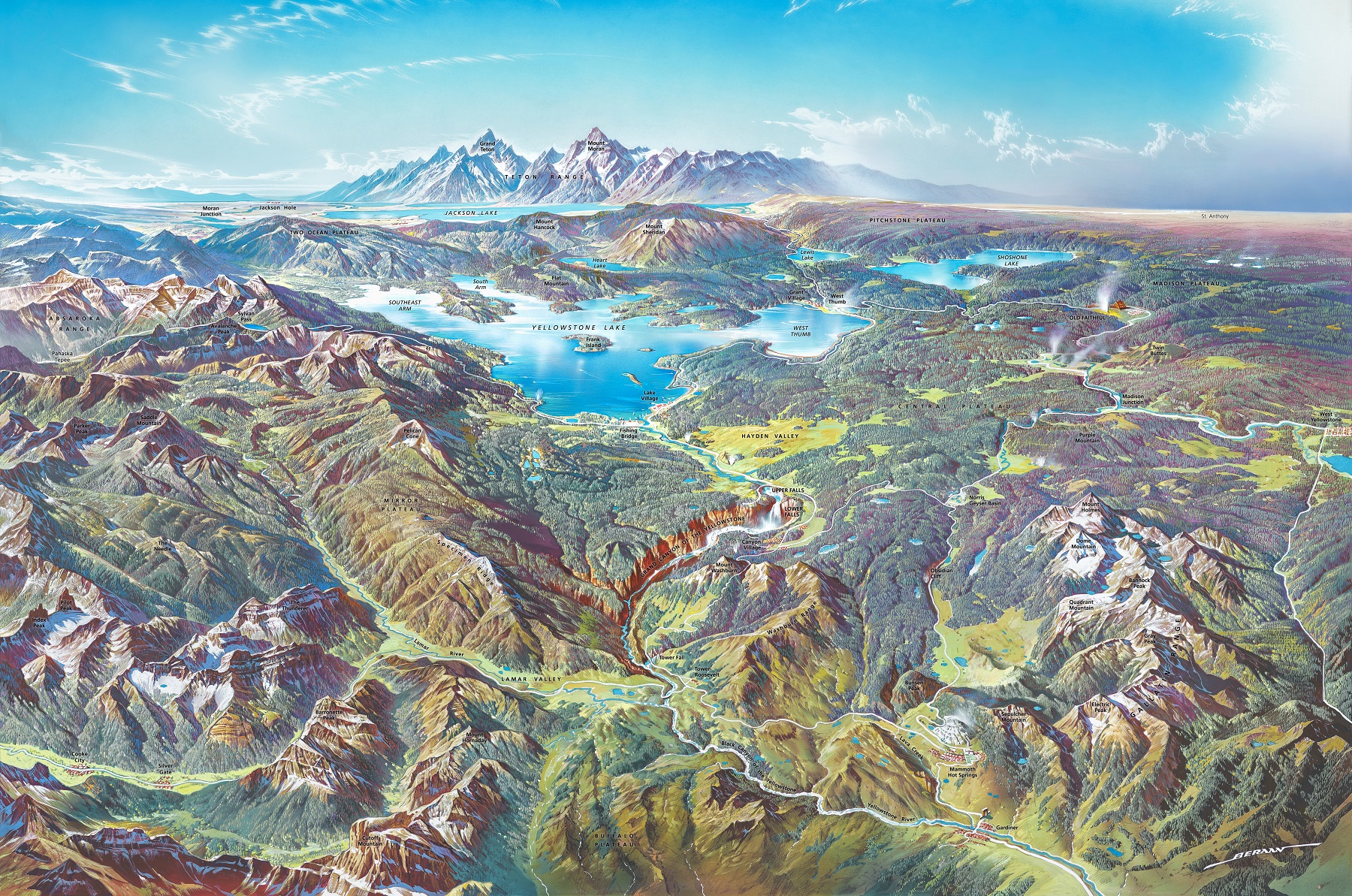
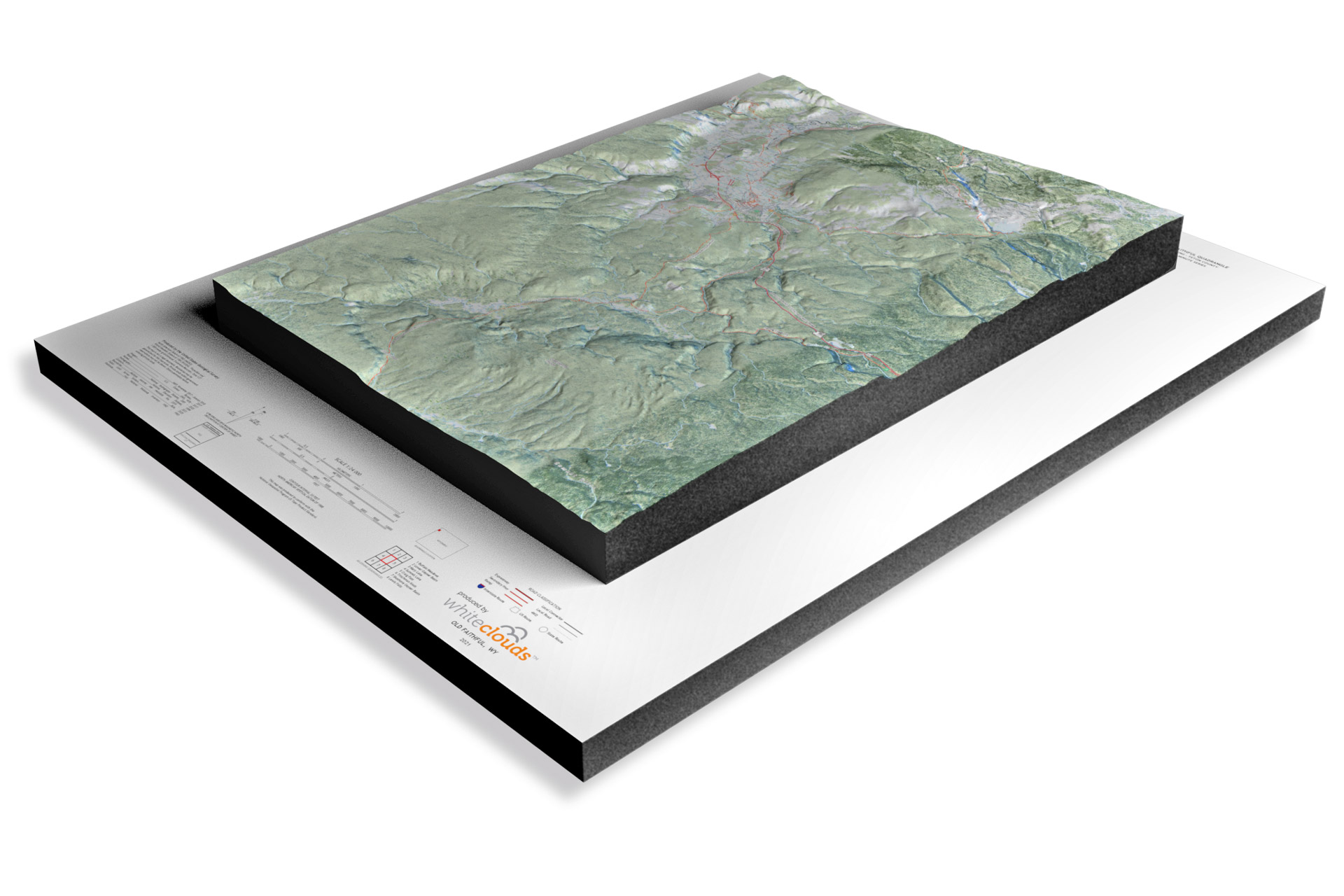
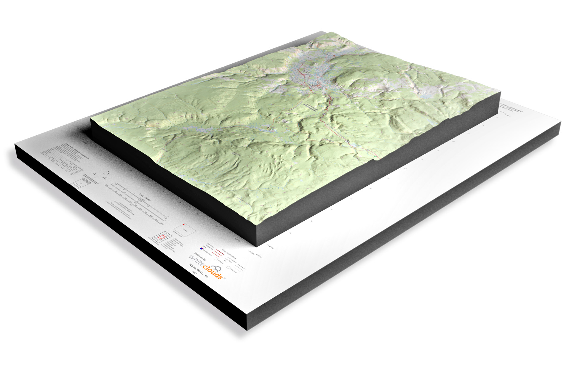
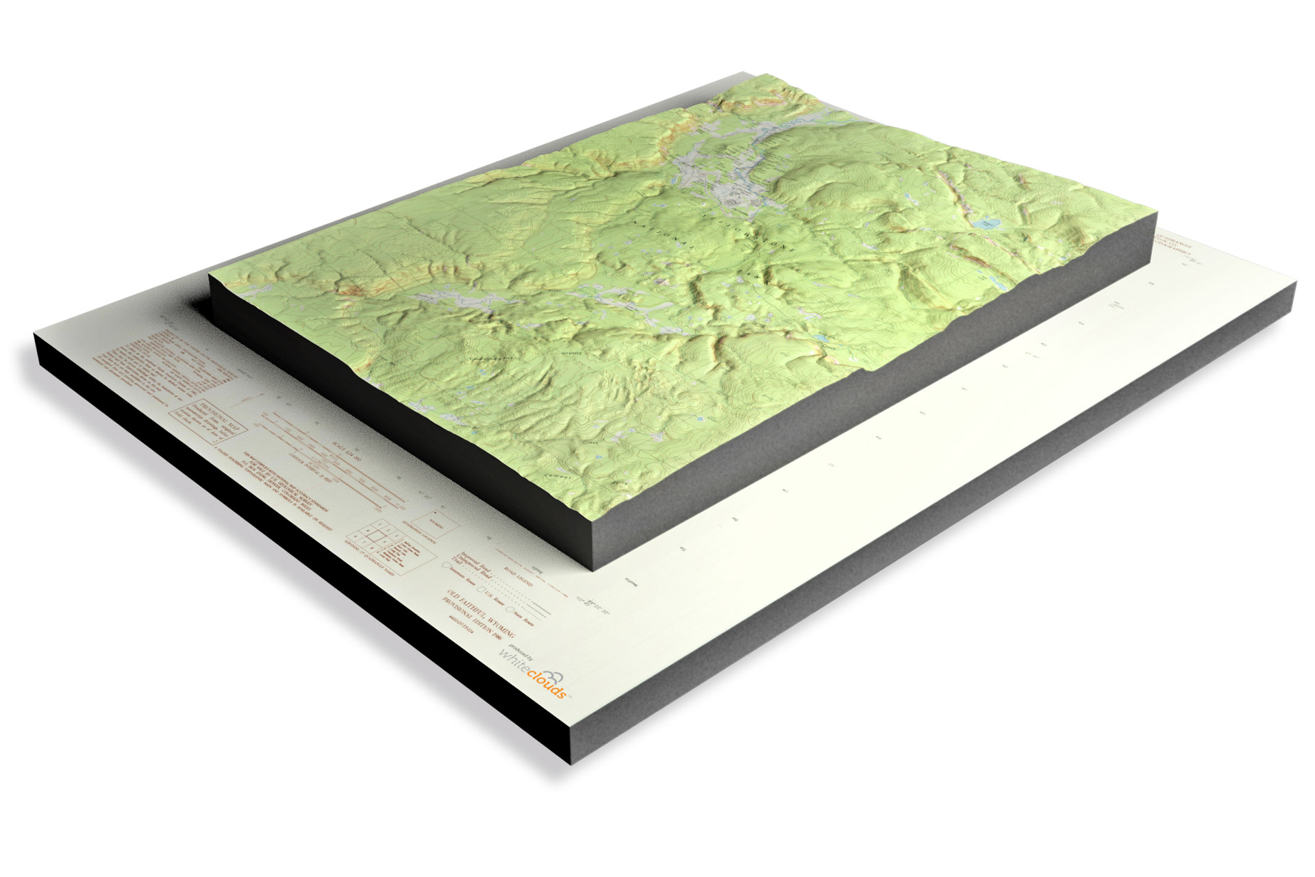
Yellowstone National Park 3D Maps
Yellowstone National Park is a wonderland of natural beauty, with its vast and intricate landscape, breathtaking geothermal features, and diverse wildlife. One of the most exciting tools available for exploring Yellowstone is its 3D maps.
First, let’s consider the benefits of 3D maps. Unlike traditional maps, which are typically flat and two-dimensional, 3D maps provide a more immersive and interactive experience. They allow you to explore Yellowstone’s landscape from all angles, getting a better sense of its contours, elevations, and depths. This can be particularly useful for hikers and backpackers who need to plan their routes carefully and avoid potential hazards.
- To learn how Yellowstone National Park 3D maps are built, click here: 3D Satellite Maps or 3D USGS Maps
- Yellowstone National Park 3D Maps-3D Raised Relief
One of the most impressive 3D maps available for Yellowstone is the Yellowstone National Park 3D Topographic Map. This map uses advanced satellite imagery and elevation data to create a stunningly detailed and accurate representation of the park’s landscape. It shows the park’s mountains, canyons, rivers, and lakes in stunning detail, allowing visitors to explore Yellowstone’s terrain in a way that was never before possible.
Another exciting 3D map available for Yellowstone is the Yellowstone Geologic 3D Map. This map provides a detailed look at the park’s geology and volcanic history, using 3D modeling and animations to bring this complex subject to life. It shows the park’s famous geothermal features, such as Old Faithful and the Grand Prismatic Spring, in incredible detail, allowing visitors to see how these natural wonders have been shaped by the forces of nature.
Perhaps the most impressive aspect of 3D maps is their ability to enhance the visitor experience. By providing a more immersive and interactive way of exploring Yellowstone, these maps can help visitors connect more deeply with the park’s natural beauty and understand its unique features in a more profound way. They can also help visitors plan their trips more effectively, ensuring that they make the most of their time in this incredible national park.
Yellowstone National Park Backcountry Maps
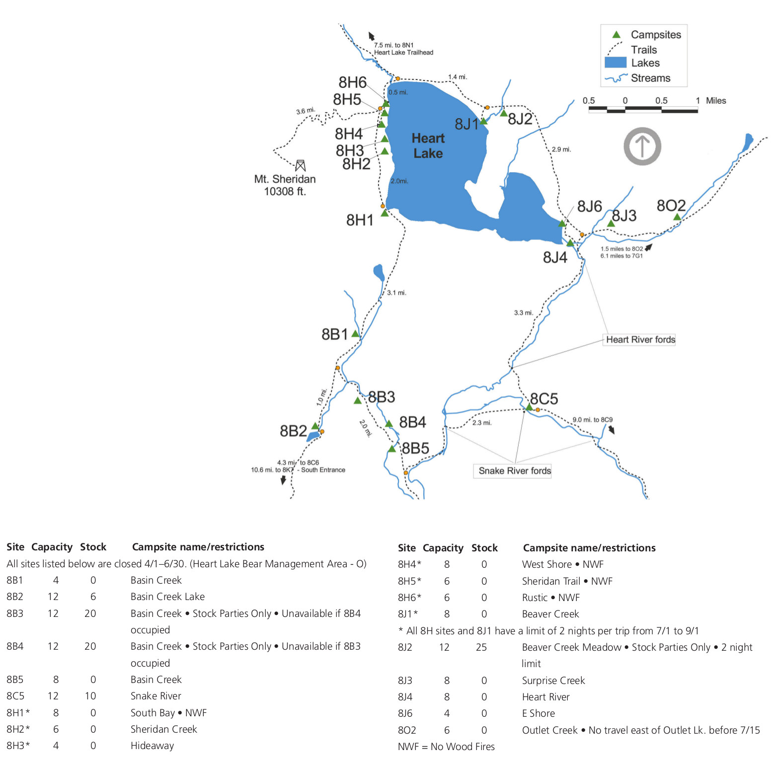
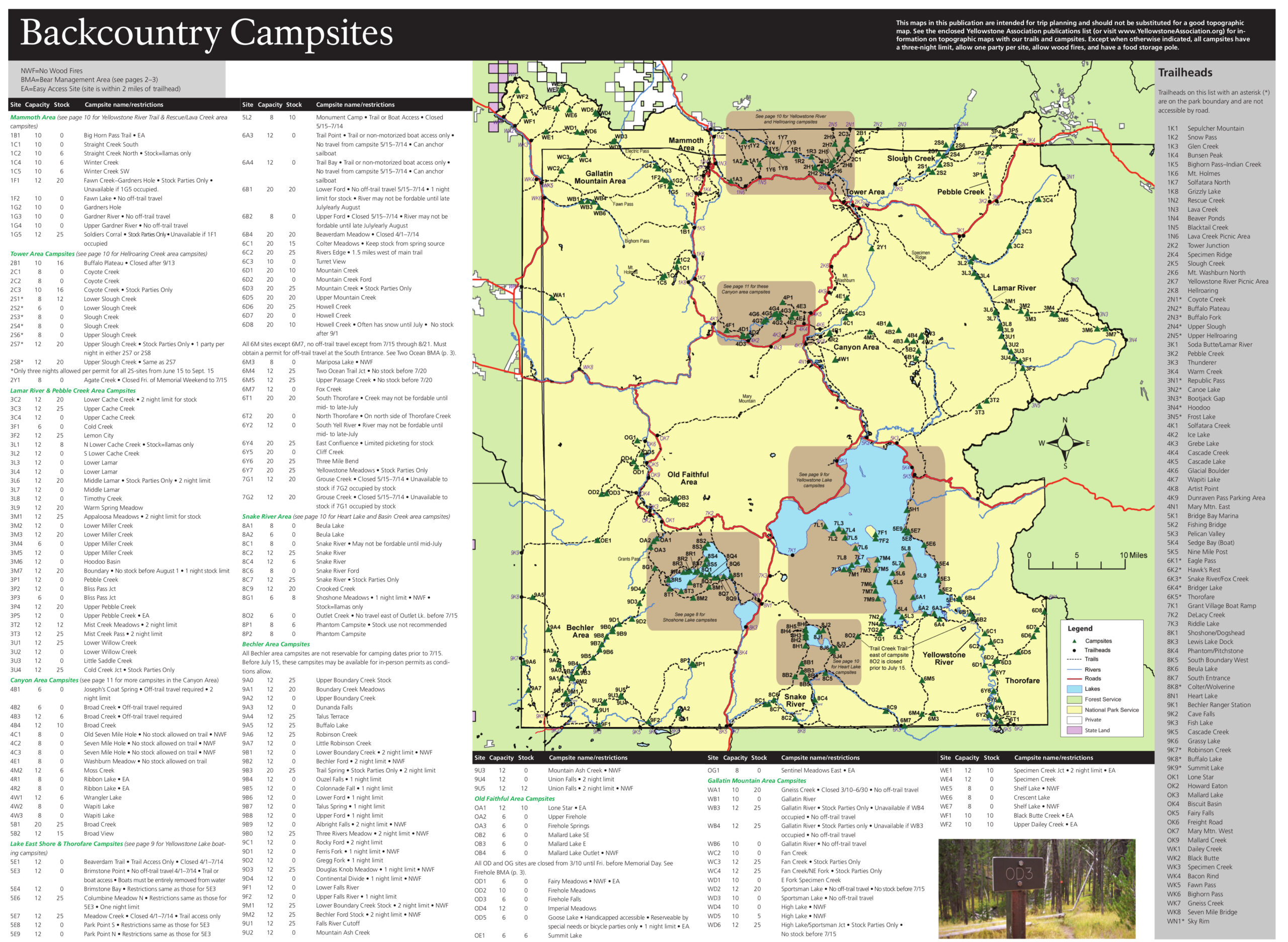
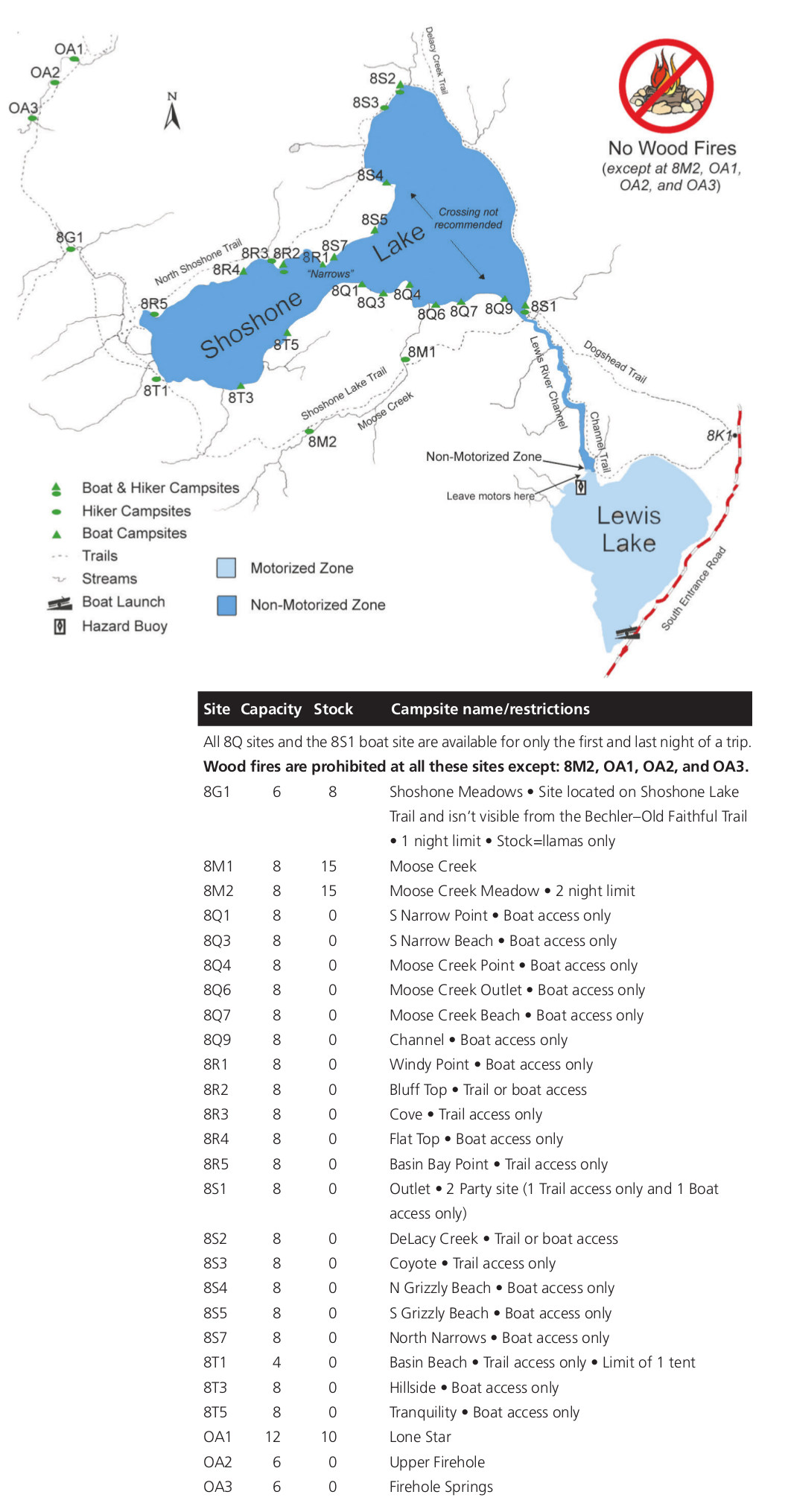
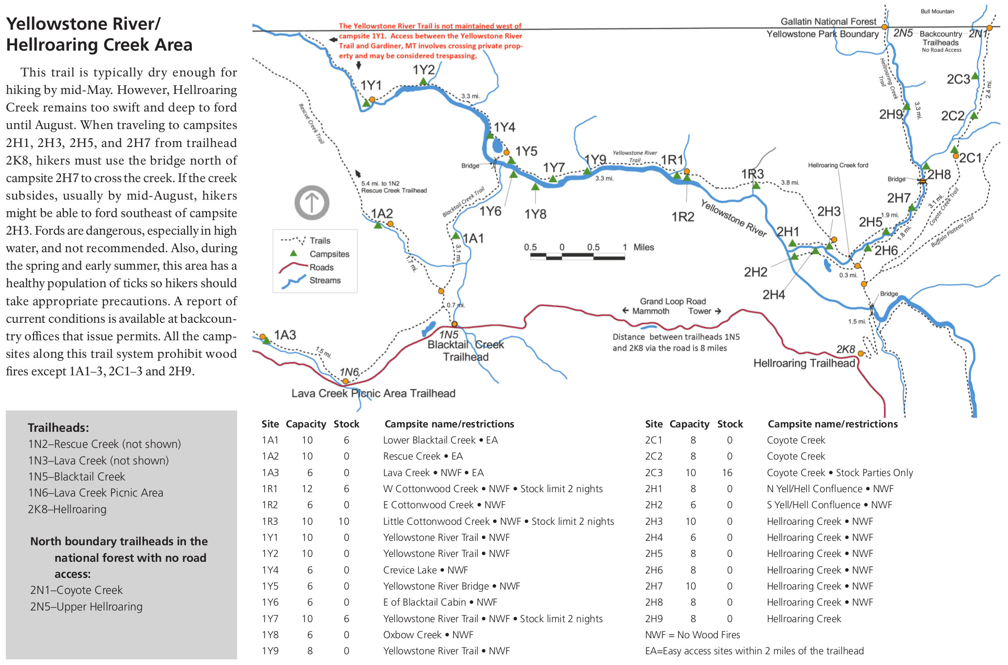
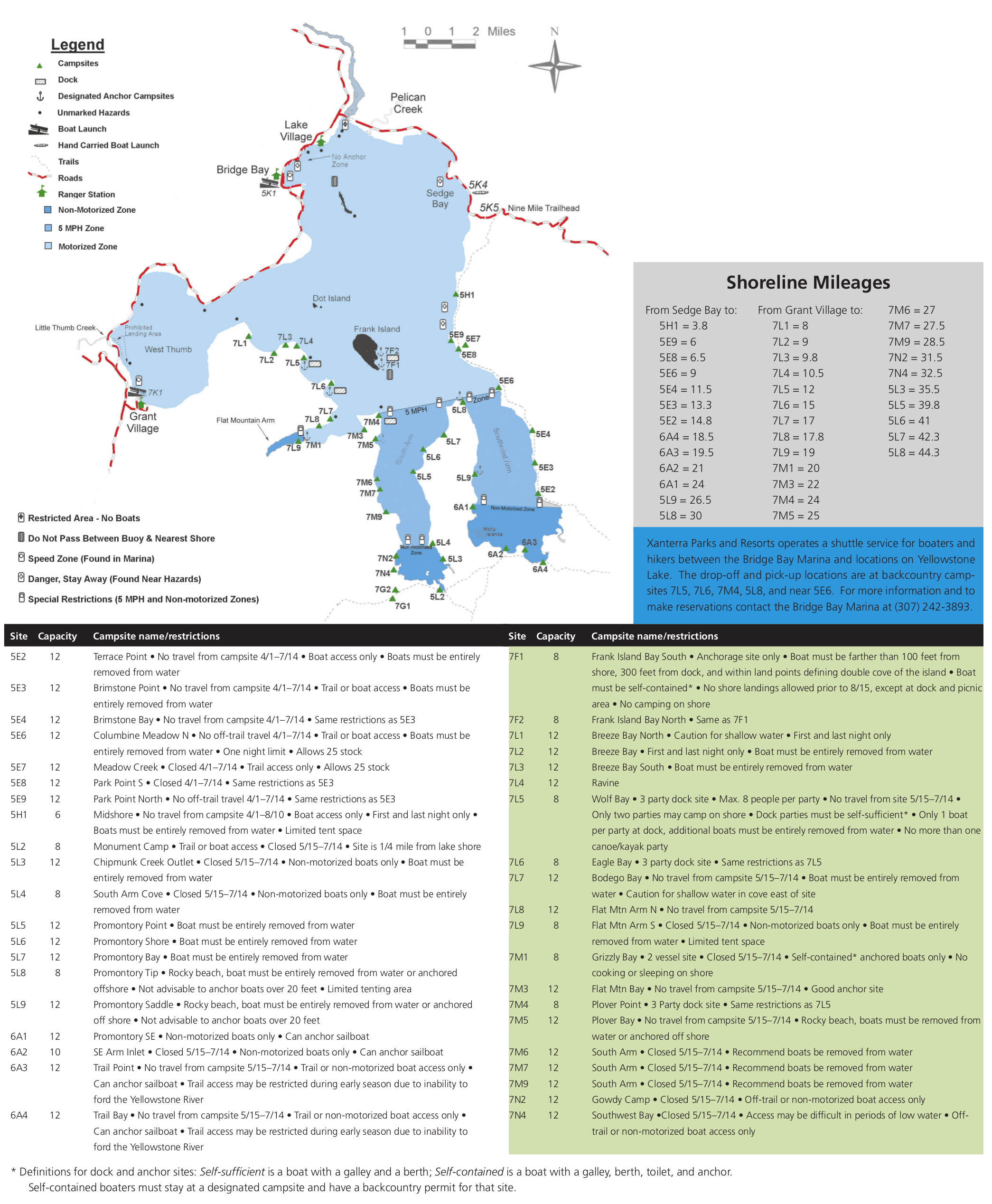
Yellowstone National Park is known for its stunning natural beauty, and much of that beauty can be found in its vast backcountry. The park offers over 2 million acres of pristine wilderness, with countless trails, campsites, and natural wonders waiting to be explored. To navigate this vast and wild landscape, visitors rely on Yellowstone backcountry maps.
Yellowstone backcountry maps are essential for any visitor looking to venture beyond the park’s roads and developed areas. These maps provide detailed information on trails, campsites, natural features, and other important landmarks, allowing visitors to plan their route and safely navigate the park’s backcountry.
- To learn how 2D/3D backcountry maps are built, click here: Satellite Maps
- Yellowstone Backcountry Trails and Campsite Maps-National Park Service
One of the most popular backcountry destinations in Yellowstone is the Thorofare region, which is the park’s most remote and isolated area. This region is home to abundant wildlife, including grizzly bears, wolves, elk, and bison. Visitors who venture into the Thorofare region often use backcountry maps to plan their route and stay safe.
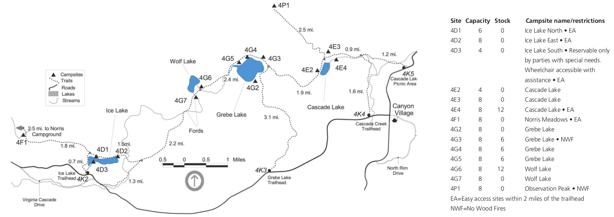
Yellowstone backcountry maps also provide valuable information on regulations and restrictions within the park’s wilderness areas. For example, visitors are required to obtain a backcountry permit before embarking on a backcountry trip, and must follow strict guidelines on food storage, campsite selection, and waste disposal. Backcountry maps help visitors understand and comply with these regulations, ensuring a safe and enjoyable trip for all.
In addition to their practical uses, Yellowstone backcountry maps also offer a glimpse into the park’s natural and cultural history. The maps include information on the geology, wildlife, and human history of the area, providing a fascinating backdrop to any backcountry adventure.
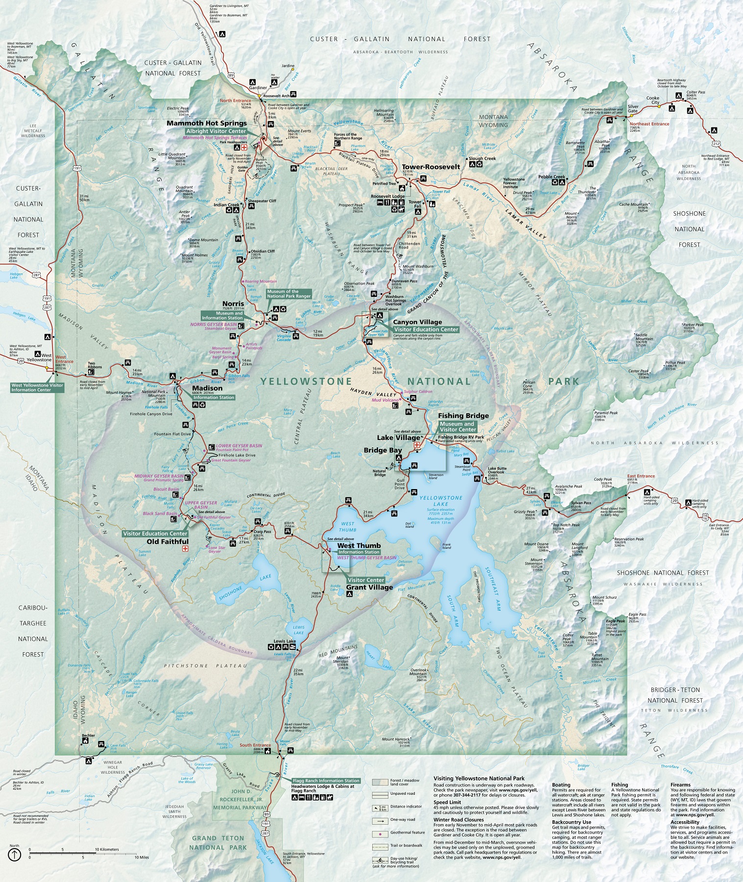
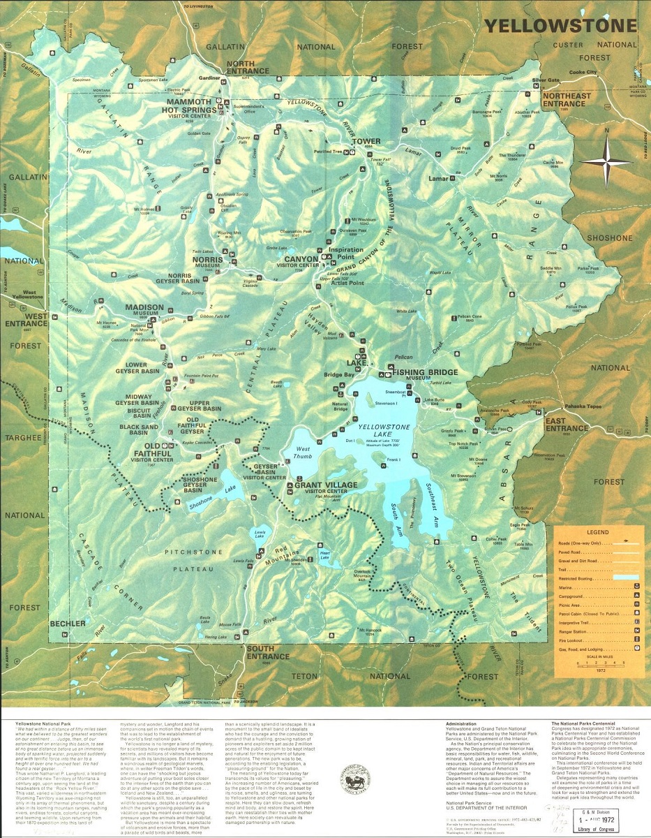
Yellowstone National Park Brochure Maps
Yellowstone National Park is a vast and complex landscape, with diverse attractions and activities for visitors to enjoy. To help visitors navigate and plan their trip, the park offers a variety of brochure maps.
Brochure maps are a convenient and easy-to-use tool for visitors to Yellowstone. These maps are typically included in the park’s official brochure or visitor guide and provide an overview of the park’s attractions, facilities, and services. They are designed to be user-friendly and informative, providing visitors with the information they need to plan their trip and make the most of their time in the park.
- To learn how 2D/3D brochure maps are built, click here: Satellite Maps
- Yellowstone National Park Maps-Canvas Prints
- Yellowstone National Park 3D Maps-3D Raised Relief
- Yellowstone National Park Maps-National Park Service
One of the most impressive brochure maps available for Yellowstone is the Yellowstone National Park Map & Guide. This guide provides a detailed overview of the park’s attractions, including its geothermal features, wildlife, and historic sites. It also includes information on hiking trails, camping facilities, and other practical information that visitors need to know. The map is easy to read and provides a clear overview of the park’s geography and layout.
Another notable brochure map available for Yellowstone is the Yellowstone Backcountry Trip Planner. This brochure provides information on backcountry camping and hiking in Yellowstone, including trail maps, permits, and safety information. It is a valuable tool for visitors who want to explore the park’s remote and less-traveled areas.
Perhaps the most impressive aspect of brochure maps is their ability to provide visitors with a comprehensive overview of the park’s attractions and facilities. By combining practical information with detailed maps, these brochures can help visitors plan their trip and make the most of their time in Yellowstone.
Yellowstone National Park Campground Maps
Yellowstone National Park is home to some of the most stunning natural landscapes and wildlife in the world, making it a popular destination for camping enthusiasts. To help visitors plan their camping trips, the park offers a variety of campground maps.
Yellowstone National Park has 12 campgrounds, each with its unique features and amenities. These campgrounds range from primitive backcountry sites to more developed campsites with modern amenities such as electricity, water, and dump stations. To help visitors navigate and plan their camping trip, each campground offers a detailed campground map.
- To learn how 2D/3D lodging maps are built, click here: Terrain Maps
- Yellowstone National Park-Campground Maps
One of the most impressive campground maps available for Yellowstone is the Madison Campground Map. This map provides visitors with a detailed overview of the campground’s layout, including the location of campsites, restrooms, and other facilities. The map also provides useful information on the campground’s amenities, including its proximity to nearby attractions and hiking trails.
Another notable campground map available for Yellowstone is the Bridge Bay Campground Map. This map features a detailed layout of the campground, including the location of campsites, restrooms, and showers. The map also provides information on the campground’s amenities, including its proximity to the lake and marina.
Perhaps the most impressive aspect of campground maps is their ability to provide visitors with a clear and detailed overview of the campground’s facilities and amenities. By combining practical information with detailed maps, these campground maps can help visitors plan their camping trip and make the most of their time in Yellowstone.
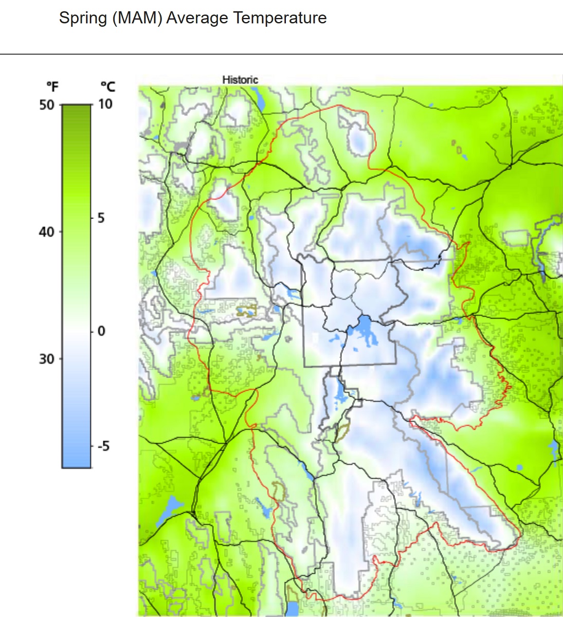
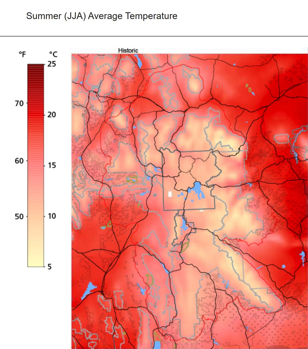
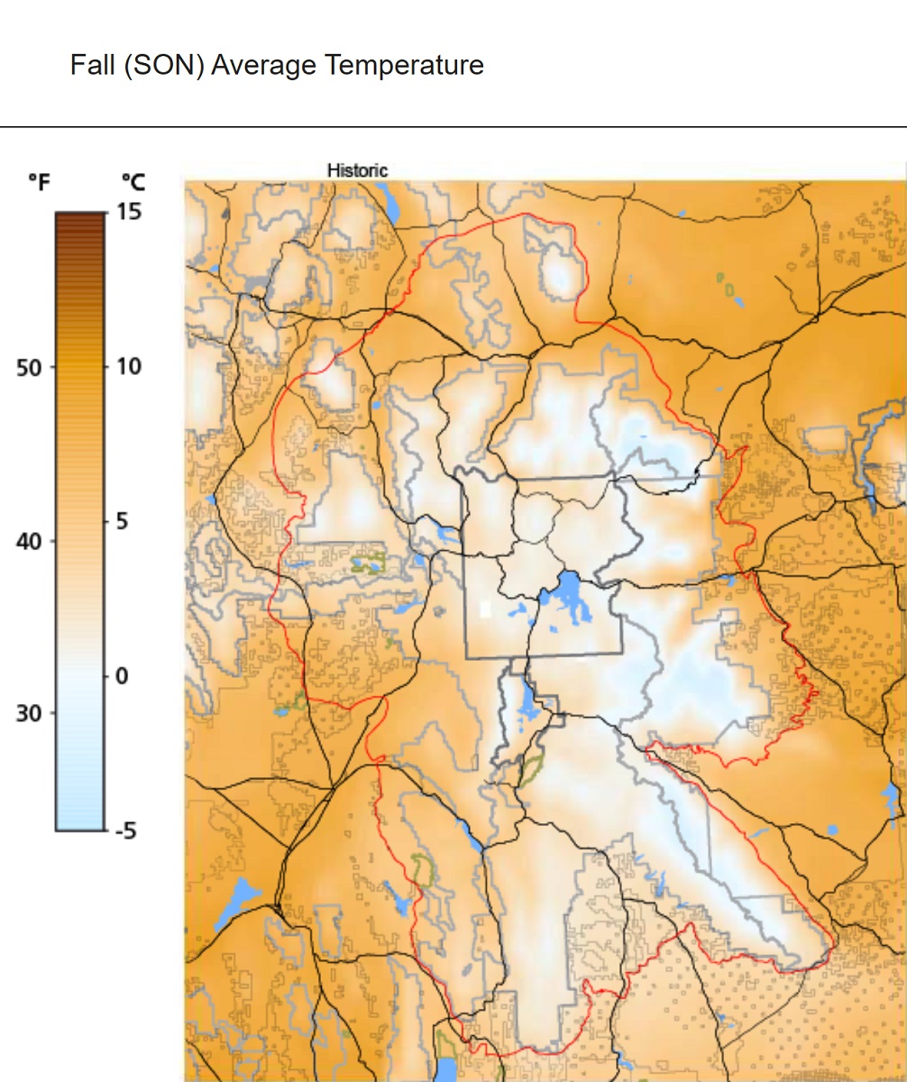
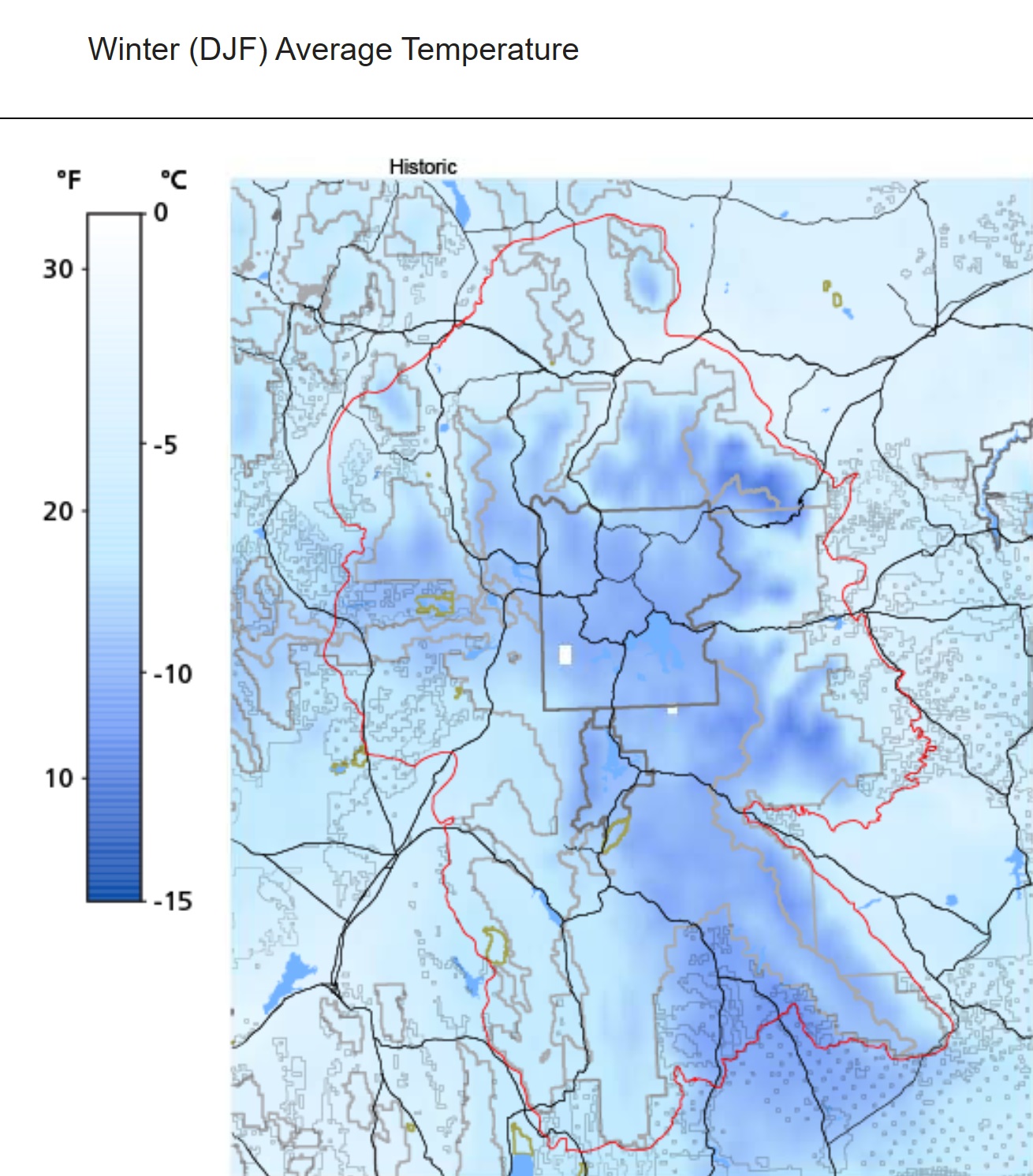
Yellowstone National Park Climate Maps
Yellowstone National Park is a vast and diverse landscape, with varied climates and weather patterns depending on the location and time of year. Yellowstone has a unique climate due to its high elevation and location in the Rocky Mountains. The park experiences four distinct seasons, each with its unique weather patterns and temperature ranges.
- To learn how 2D/3D climate maps are built, click here: Satellite Maps
- Yellowstone National Park Climate Maps-NPS Climate Explorer
- Wyoming Climate Maps-NOAA Climate Maps (National Oceanic and Atmospheric Administration)
One of the most impressive climate maps available for Yellowstone is the Average Temperature and Precipitation Map. This map provides visitors with a detailed overview of the park’s temperature and precipitation patterns throughout the year. It includes a color-coded legend that shows the average temperature and precipitation for each month, making it easy for visitors to plan their trip around the weather. The Yellowstone National Parks Climate Explorer is available here:
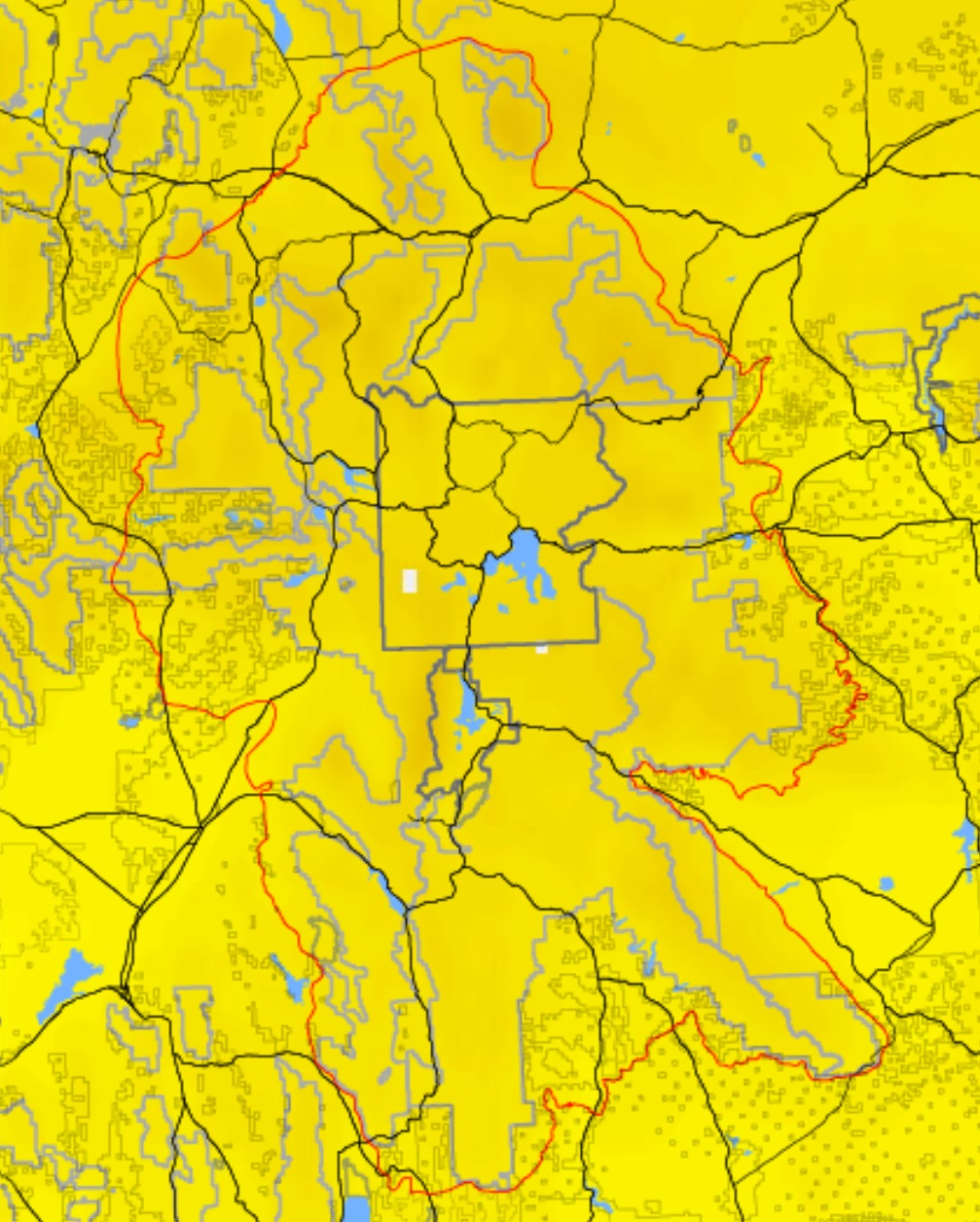
Another notable climate map available for Yellowstone is the Snow Depth Map. This map provides visitors with real-time information on the depth of snow throughout the park, which can be especially important for winter activities such as cross-country skiing and snowmobiling. The map also includes information on road closures and other winter weather advisories.
Perhaps the most impressive aspect of climate maps is their ability to provide visitors with a comprehensive understanding of the weather patterns and temperature ranges in Yellowstone. By combining practical information with detailed maps, these climate maps can help visitors plan their trip and prepare for the weather.
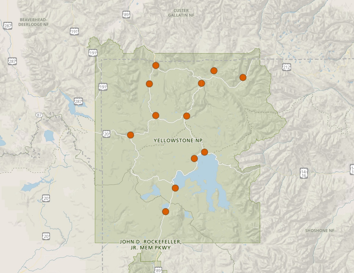
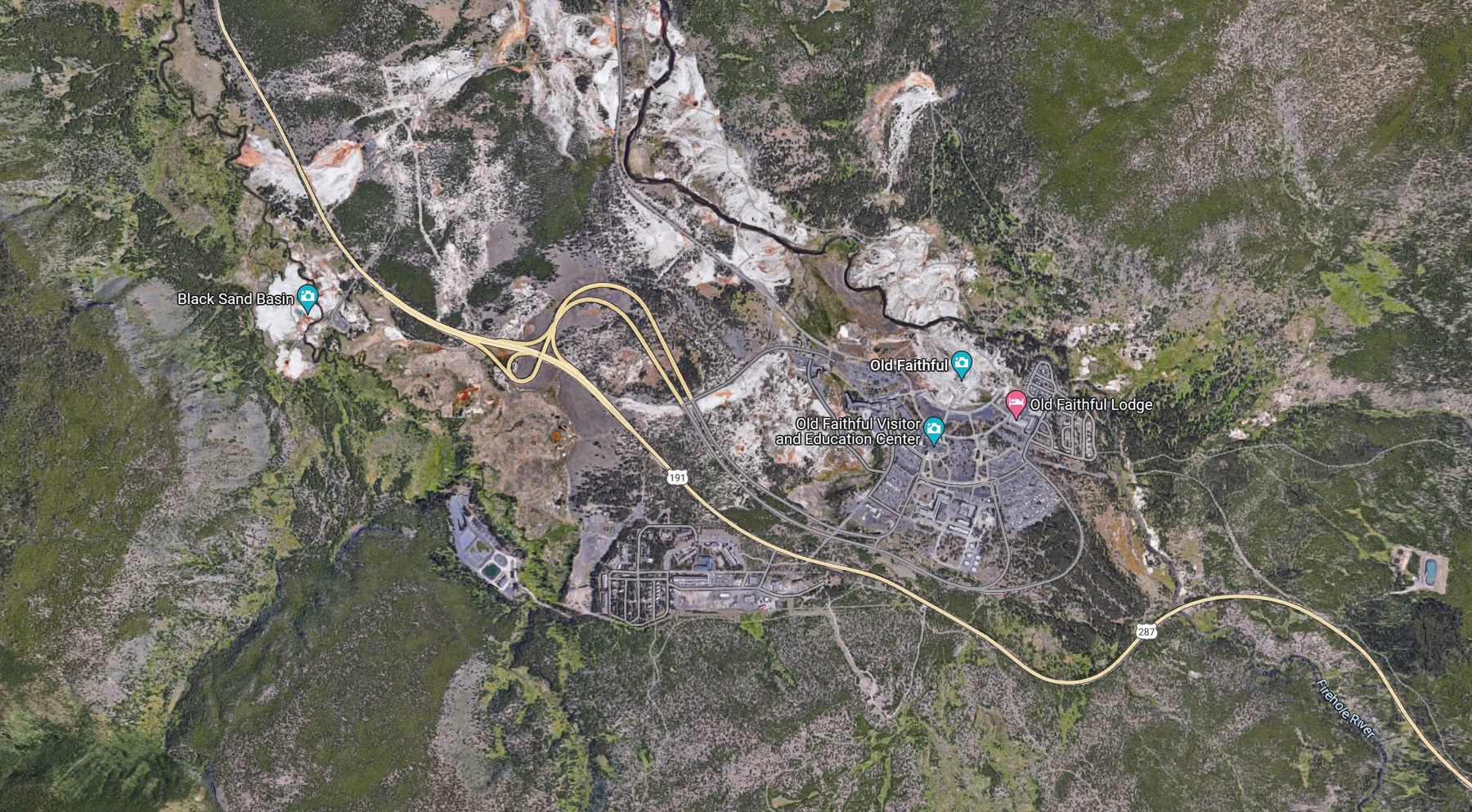
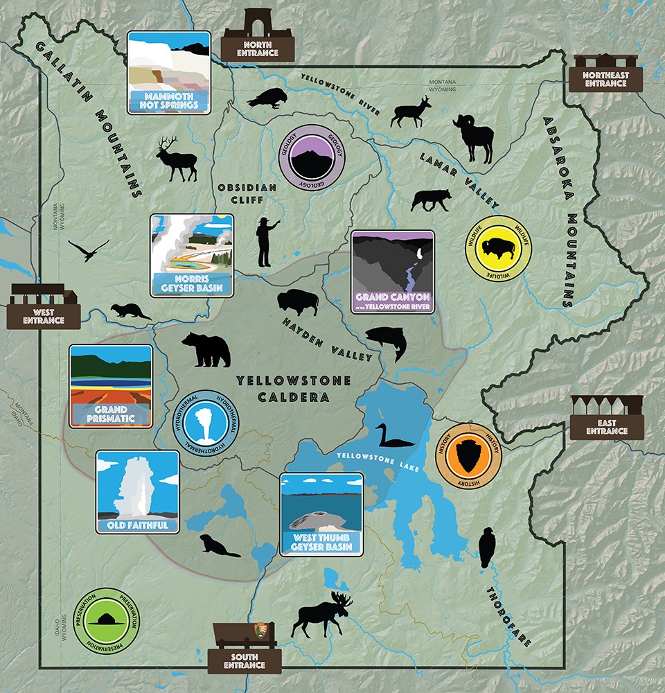
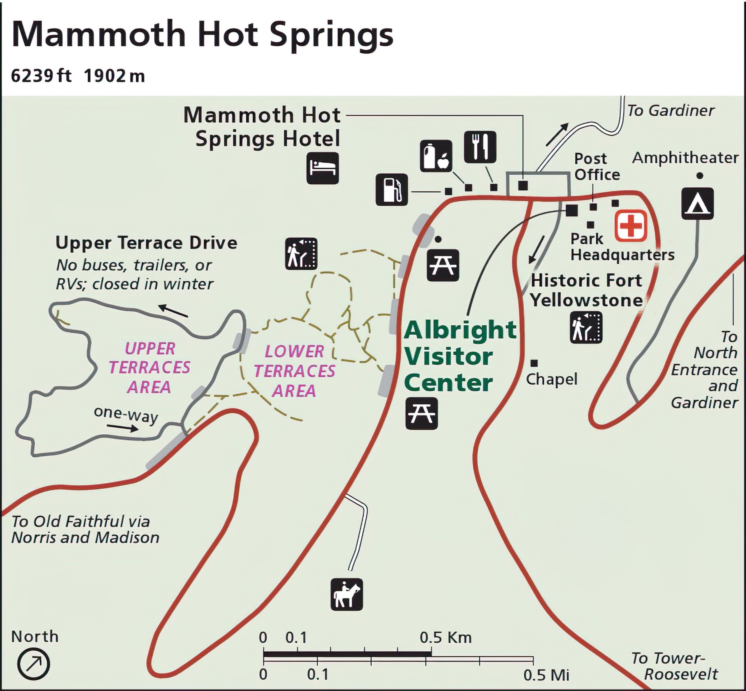
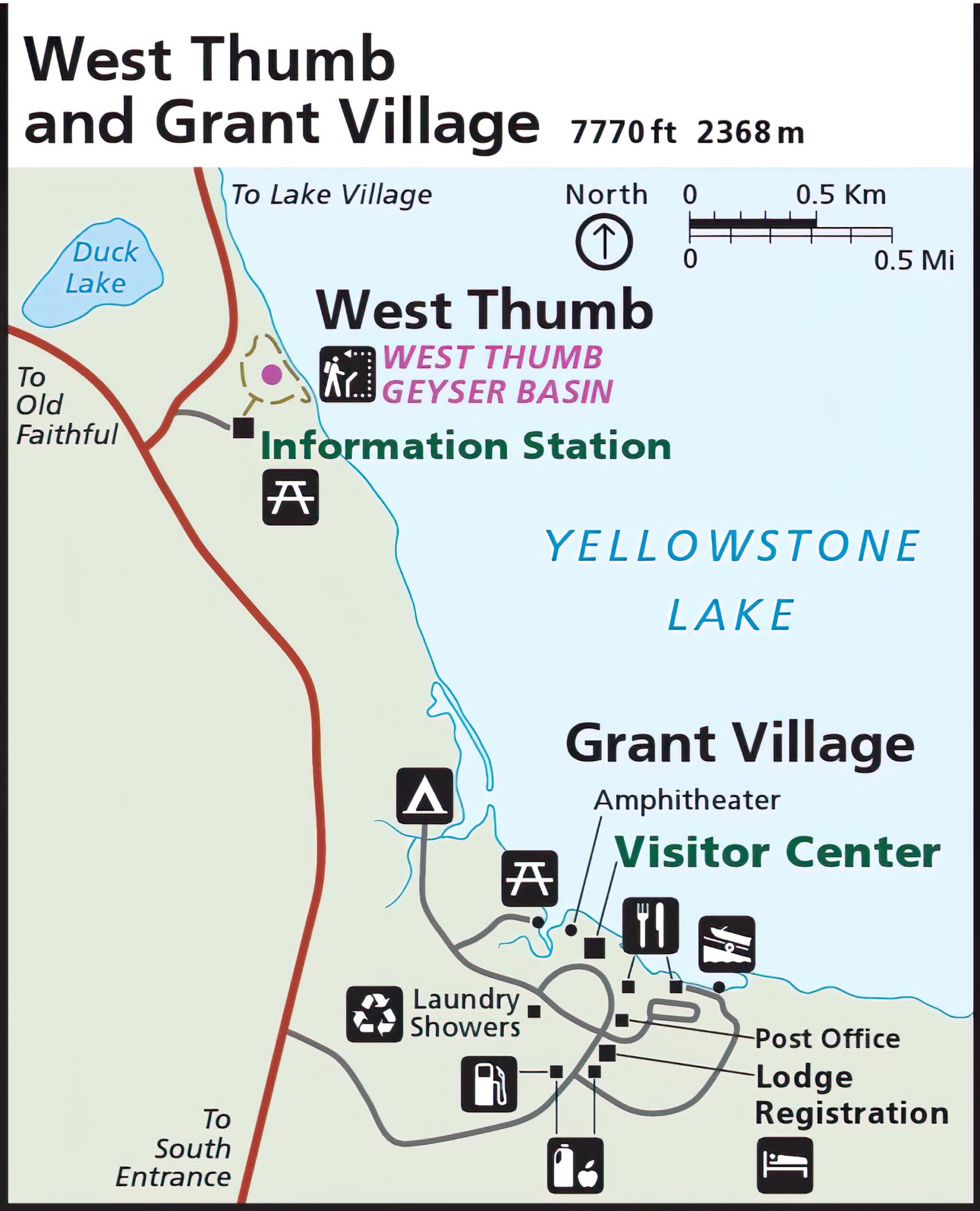
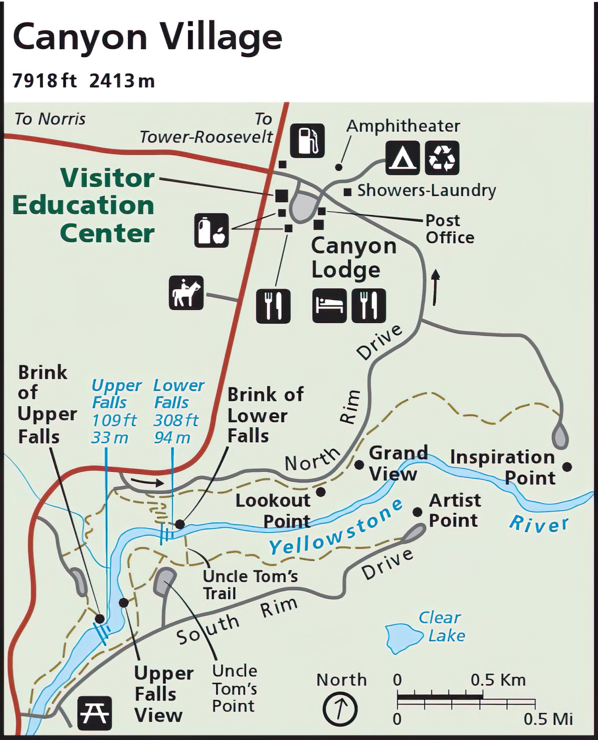
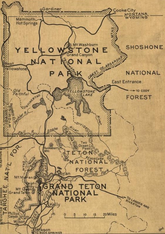
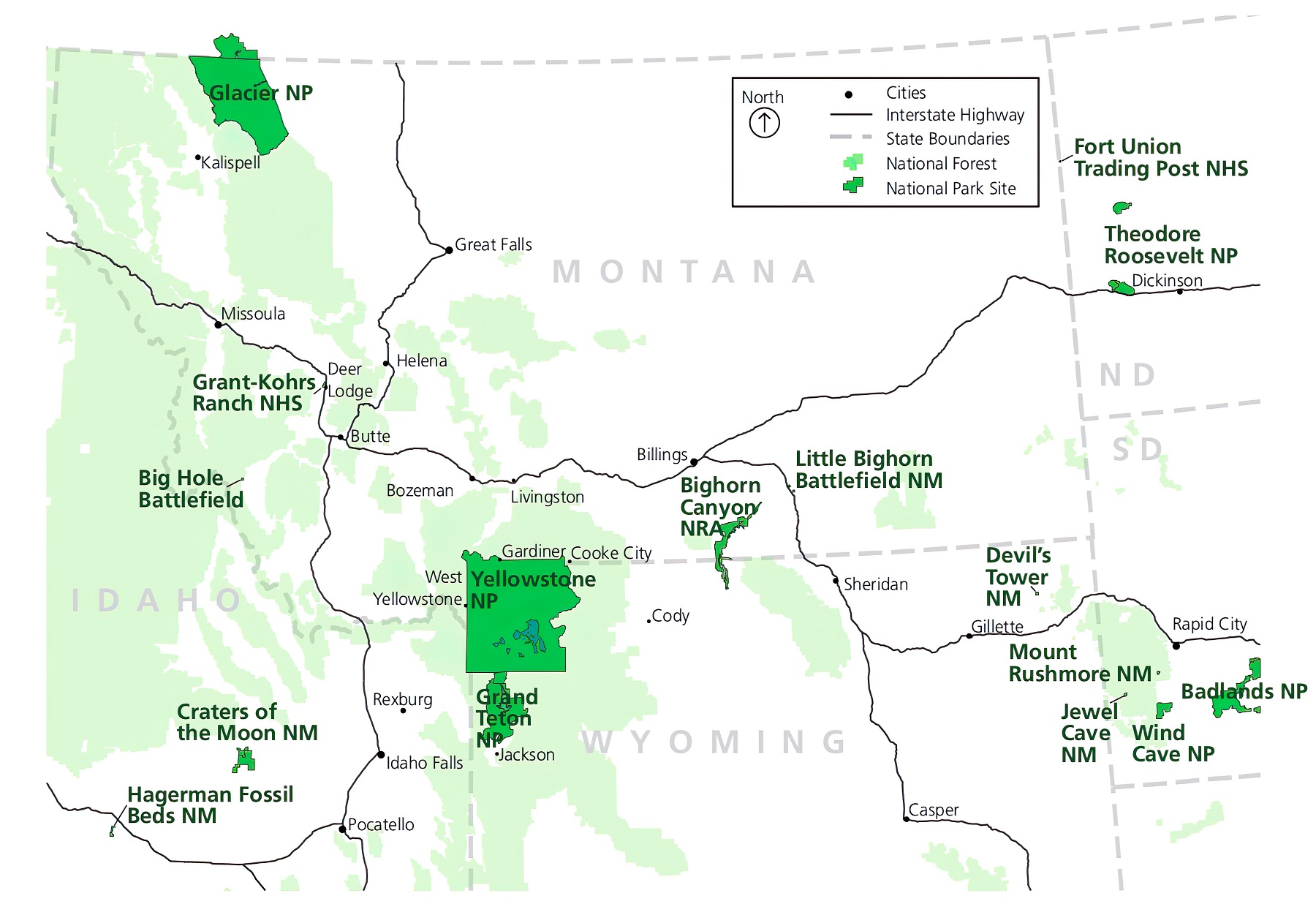
Yellowstone National Park Destination Maps
Yellowstone National Park is a vast and diverse landscape, with numerous destinations and points of interest scattered throughout its expansive terrain. To help visitors explore and discover these destinations, the park offers a variety of destination maps.
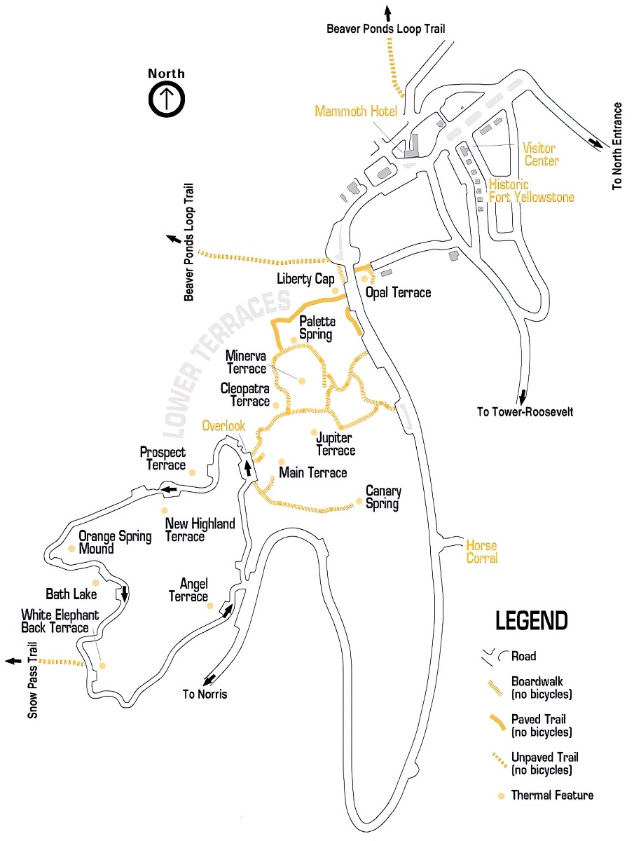
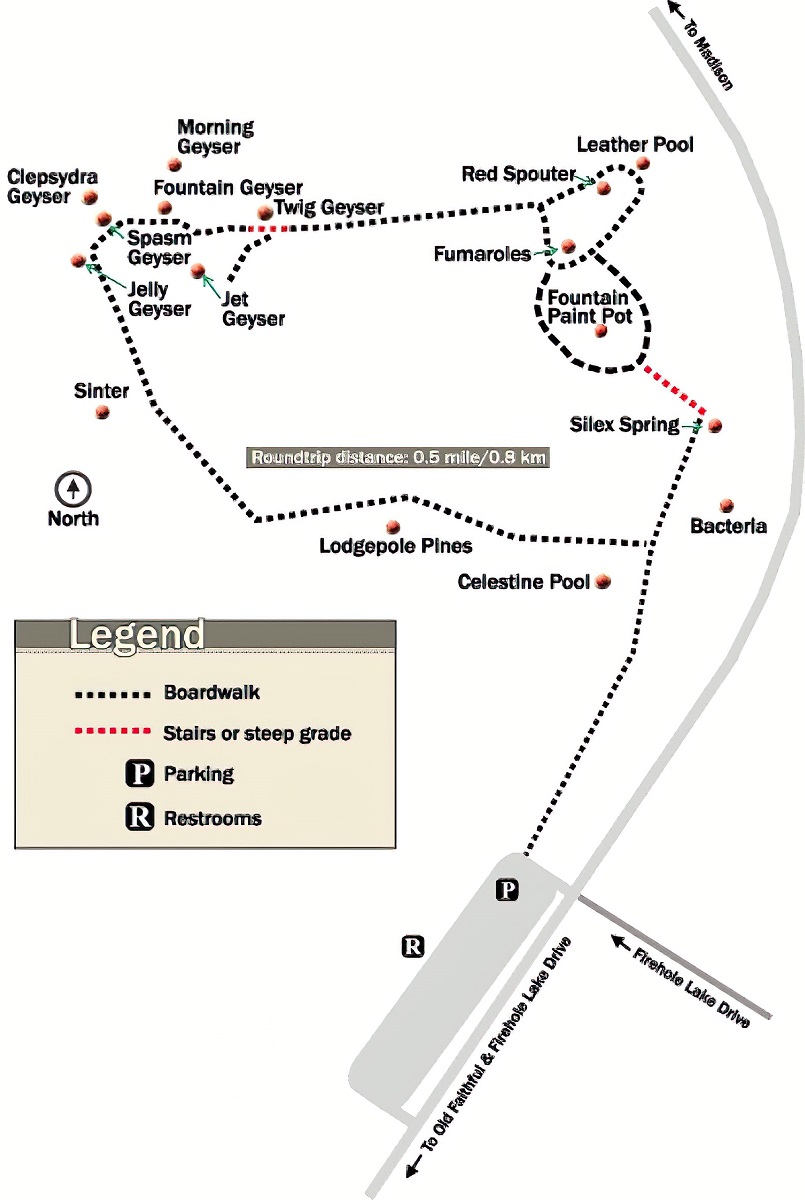
Destination maps are a type of map that highlights the park’s various destinations and points of interest, such as geysers, hot springs, waterfalls, and hiking trails. These maps are particularly useful for visitors who want to explore the park’s many attractions and make the most of their time in Yellowstone.
- To learn how 2D/3D destination maps are built, click here: Terrain Maps
- Yellowstone National Park-Plan Your Visit
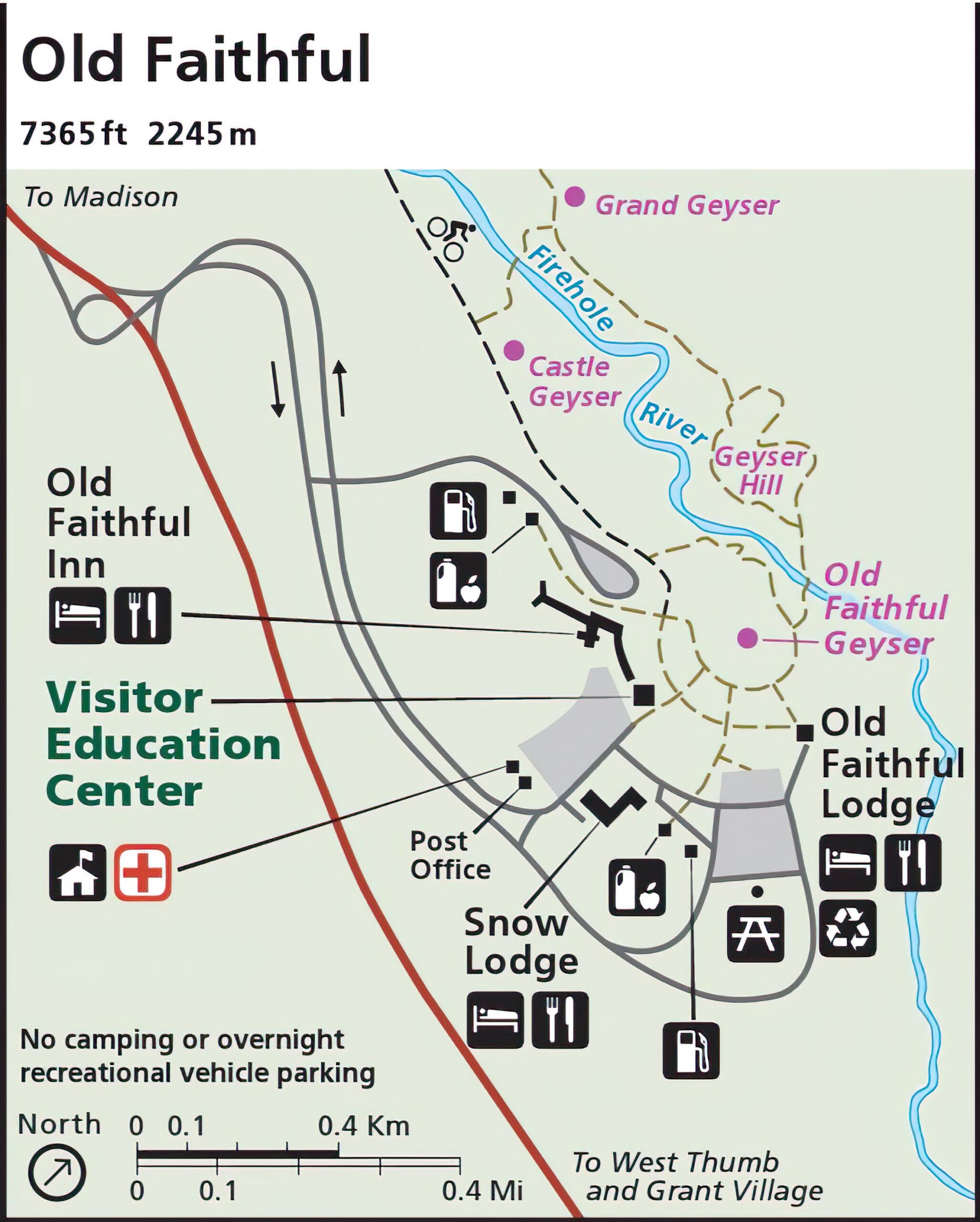
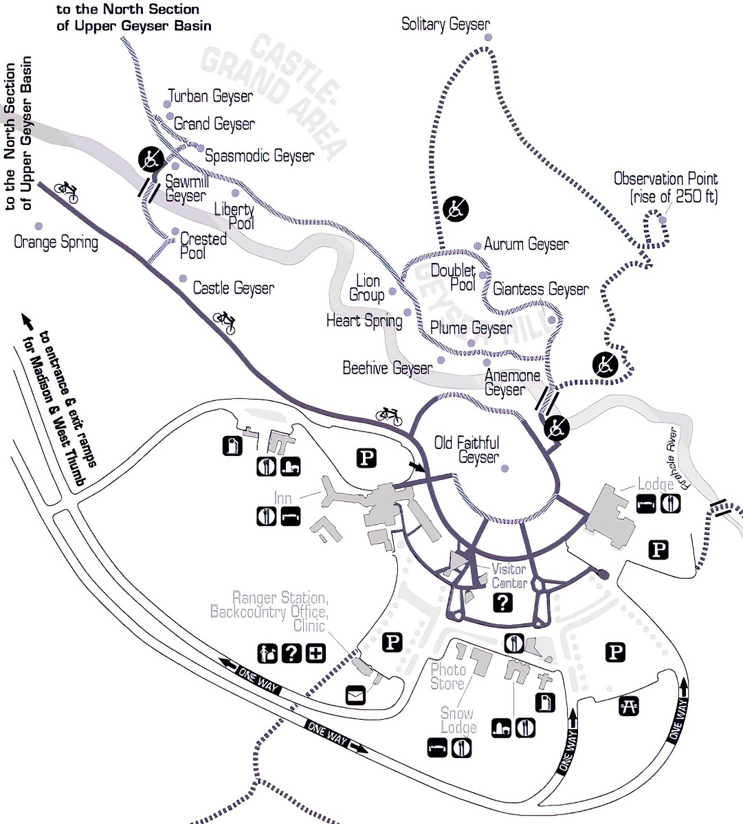
One of the most impressive destination maps available for Yellowstone is the Old Faithful Area Map. This map provides visitors with a comprehensive overview of the Old Faithful area, which is one of the park’s most popular destinations. The map includes information on the geyser’s eruption schedule, as well as information on nearby trails, visitor centers, and other points of interest.
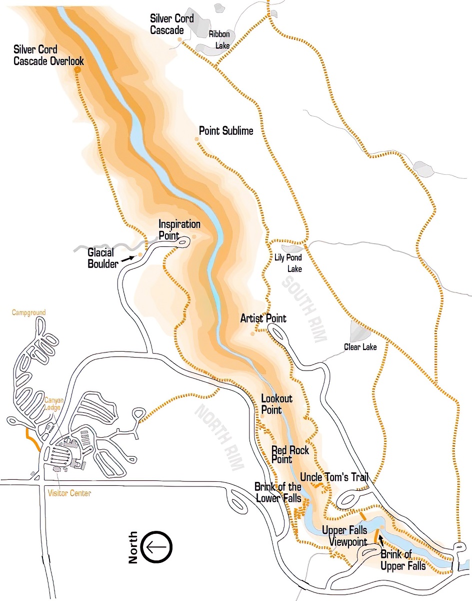
Another notable destination map available for Yellowstone is the Canyon Area Map. This map provides visitors with a detailed overview of the park’s Canyon area, which is renowned for its stunning waterfalls and dramatic landscapes. The map includes information on the park’s numerous hiking trails, as well as information on nearby campgrounds and lodging options.
Perhaps the most impressive aspect of destination maps is their ability to provide visitors with a comprehensive overview of the park’s various attractions and points of interest. By combining practical information with detailed maps, these destination maps can help visitors plan their itinerary and make the most of their time in Yellowstone.
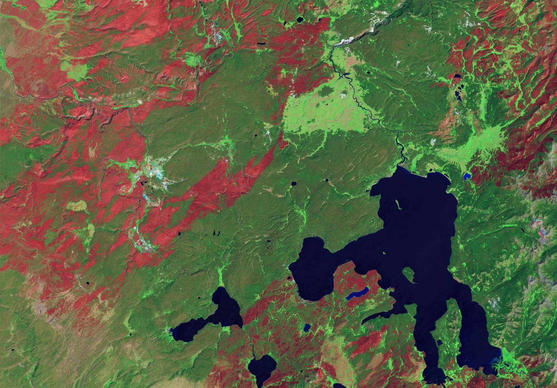
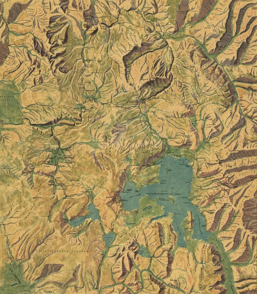
Yellowstone National Park Elevation Maps
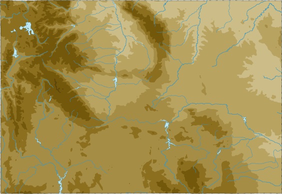
Yellowstone National Park is home to a wide range of elevations, from deep valleys and winding rivers to towering mountains and sweeping plateaus. Elevation maps are a type of map that uses contour lines to depict the shape and elevation of the land. In Yellowstone, elevation maps are particularly useful for hikers and backpackers, as they can provide a detailed overview of the park’s terrain and help visitors plan their routes.
First, let’s talk about what an elevation map is. An elevation map is a type of topographic map that shows the heights and depths of various landforms in a particular area. These maps use contour lines to indicate the elevation of different parts of the terrain. These lines are often color-coded to show the different elevations.
- To learn how 2D/3D elevation maps are built, click here: Elevation Maps
Now, let’s talk about the colors. The colors used on Yellowstone’s elevation maps are not just random. They are chosen carefully to represent different elevations. The lowest elevations are usually represented by shades of green, while higher elevations are represented by shades of brown and orange. The highest elevations, which can be found in the Absaroka Range, are represented by shades of blue and purple.
The colors used on the elevation maps of Yellowstone not only represent different elevations, but they also create a visually stunning image of the park’s topography. The colors help visitors to better understand the lay of the land, and they also add to the park’s overall beauty.
The colors used on Yellowstone’s elevation maps are not just for aesthetic purposes. They also serve a functional purpose. The colors help hikers and backpackers to navigate the park’s rugged terrain. By looking at the colors on the map, they can determine the best route to take based on the terrain’s elevation.
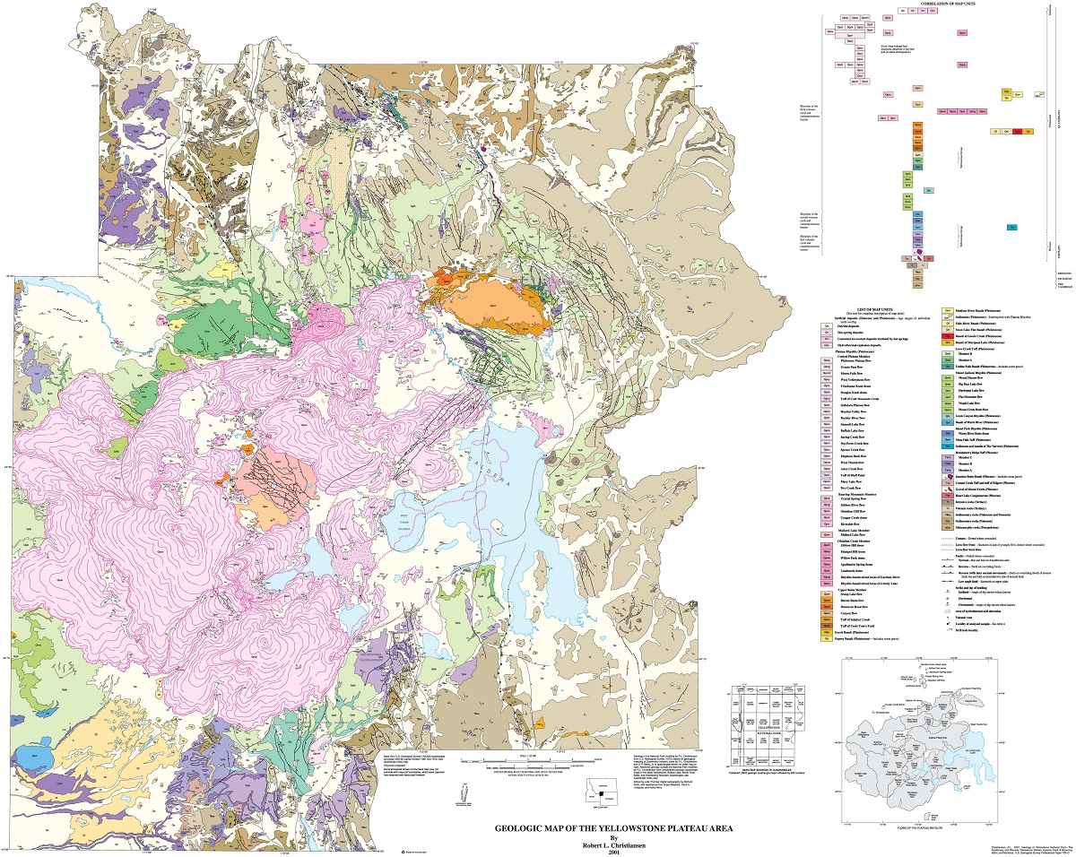
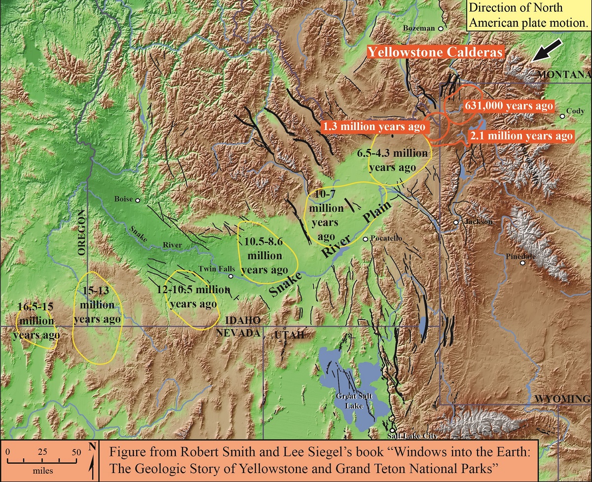
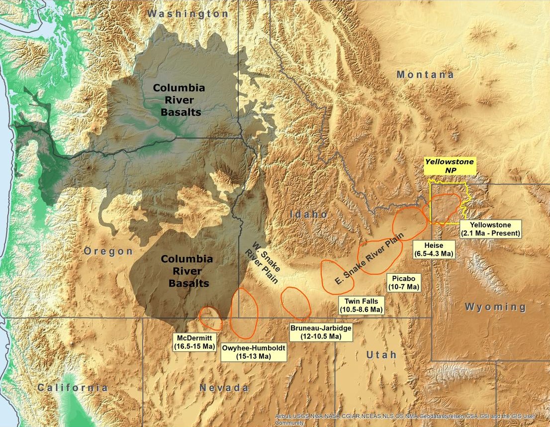
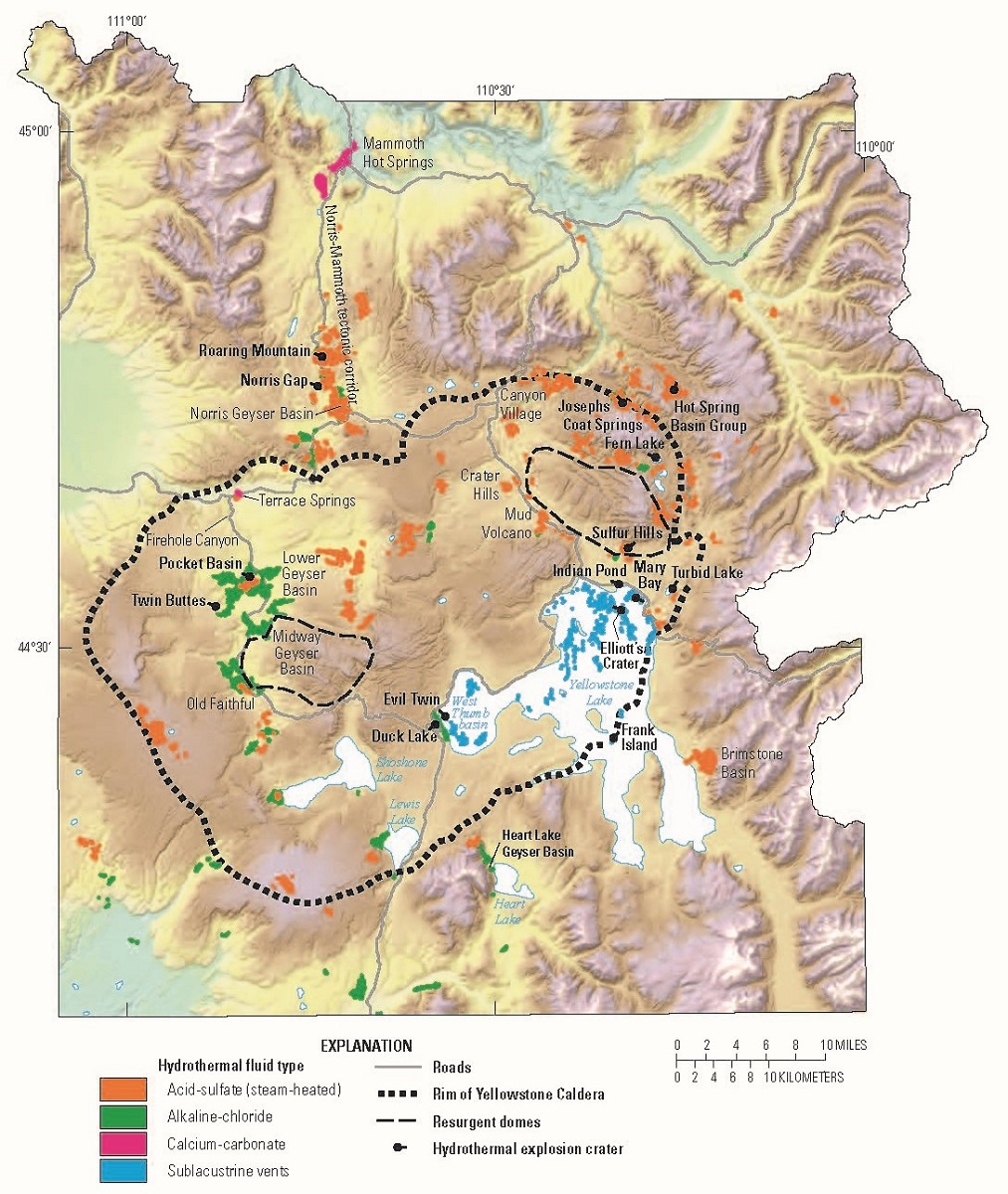
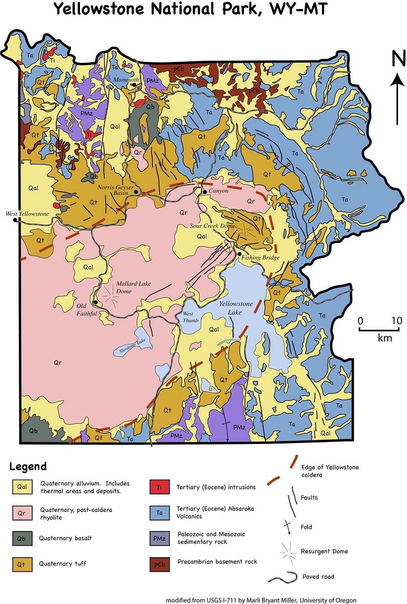
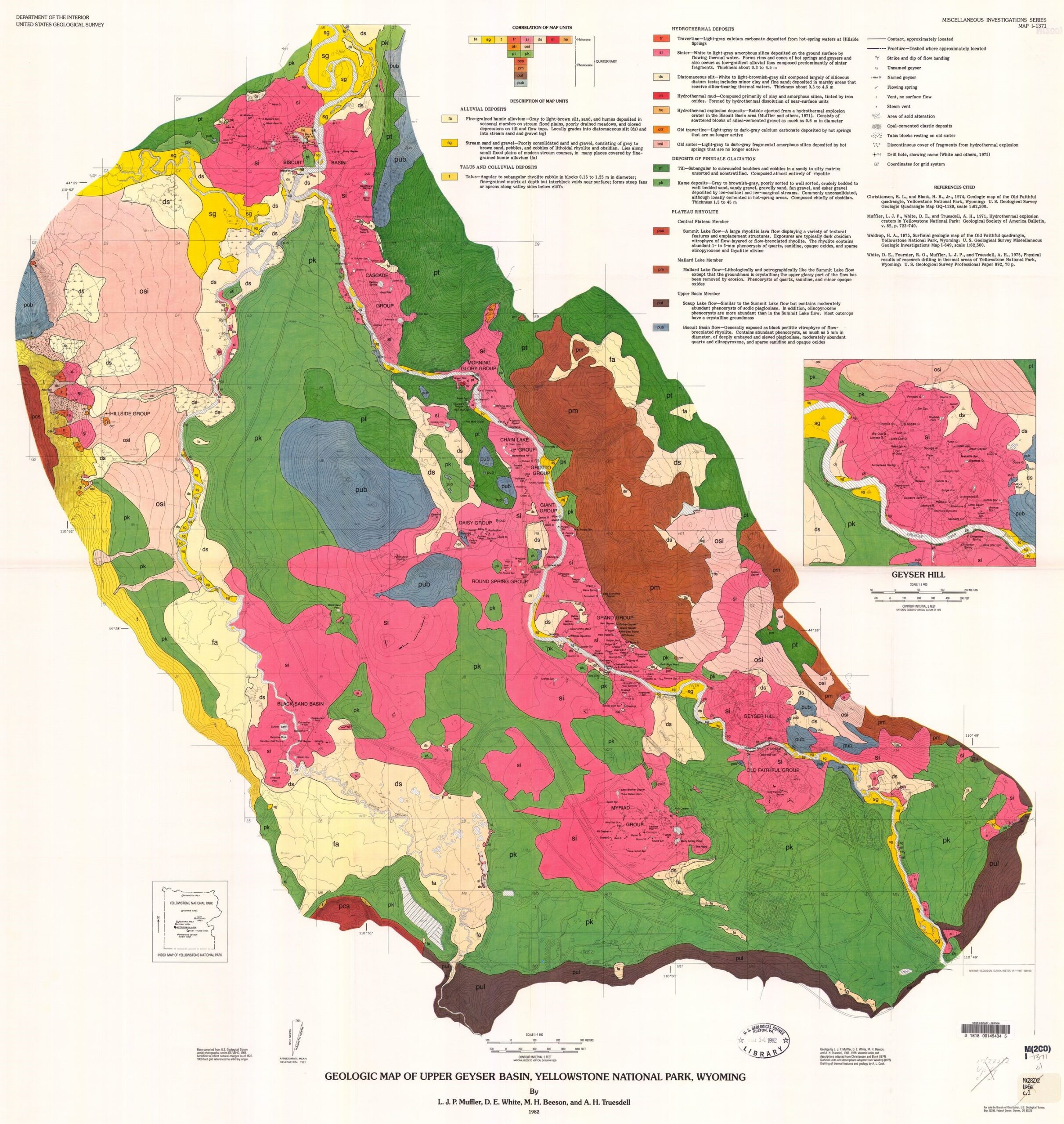
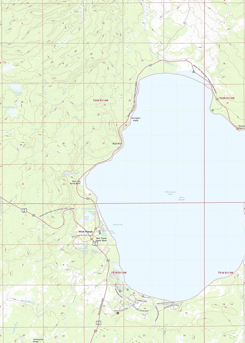
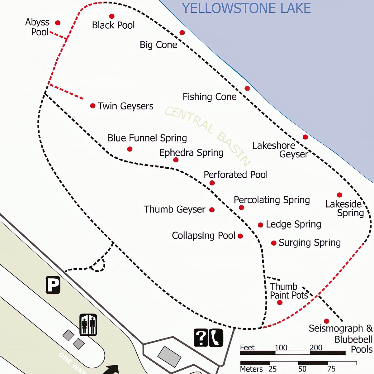
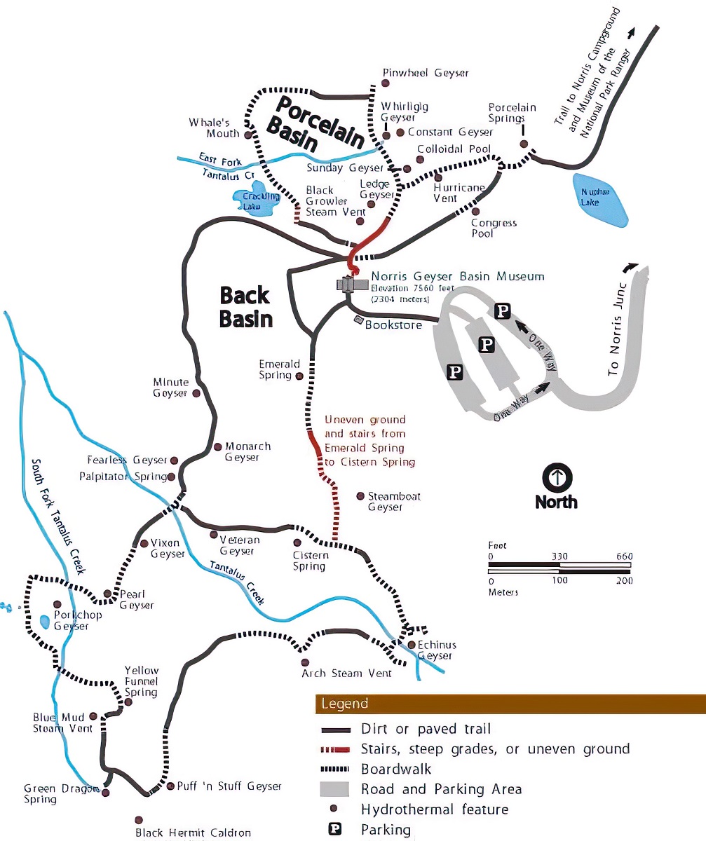
Yellowstone National Park Geologic Maps
Yellowstone National Park is famous for its geothermal features, including geysers, hot springs, and mud pots. But the park is also home to a fascinating geological history, shaped by volcanic activity and tectonic forces over millions of years.
Geologic maps are a type of map that depicts the geological features of a given area, including rock formations, faults, and other geological features. In Yellowstone, geologic maps are particularly useful for visitors who want to learn more about the park’s geological history and how it has shaped the park’s unique landscapes.
- To learn how 2D/3D geology maps are built, click here: Geologic Maps
- Yellowstone National Park Geologic Maps: National Geologic Database
One of the most impressive geologic maps available for Yellowstone is the Geologic Map of the Yellowstone National Park Area. This map provides visitors with a comprehensive overview of the park’s geologic history, including information on its volcanic past, tectonic activity, and other geological features. The map includes detailed depictions of the park’s many geothermal features, as well as information on nearby hiking trails and other points of interest.

Another notable geologic map available for Yellowstone is the West Thumb Geyser Basin Geologic Map. This map provides visitors with a detailed overview of the geologic history of the West Thumb Geyser Basin, which is one of the park’s most popular geothermal attractions. The map includes detailed depictions of the basin’s many geothermal features, as well as information on nearby hiking trails and other points of interest.
Perhaps the most impressive aspect of geologic maps is their ability to provide visitors with a deeper understanding of the park’s geological history and how it has shaped the park’s unique landscapes. By combining practical information with detailed maps, these geologic maps can help visitors appreciate the incredible natural forces that have shaped Yellowstone over millions of years.
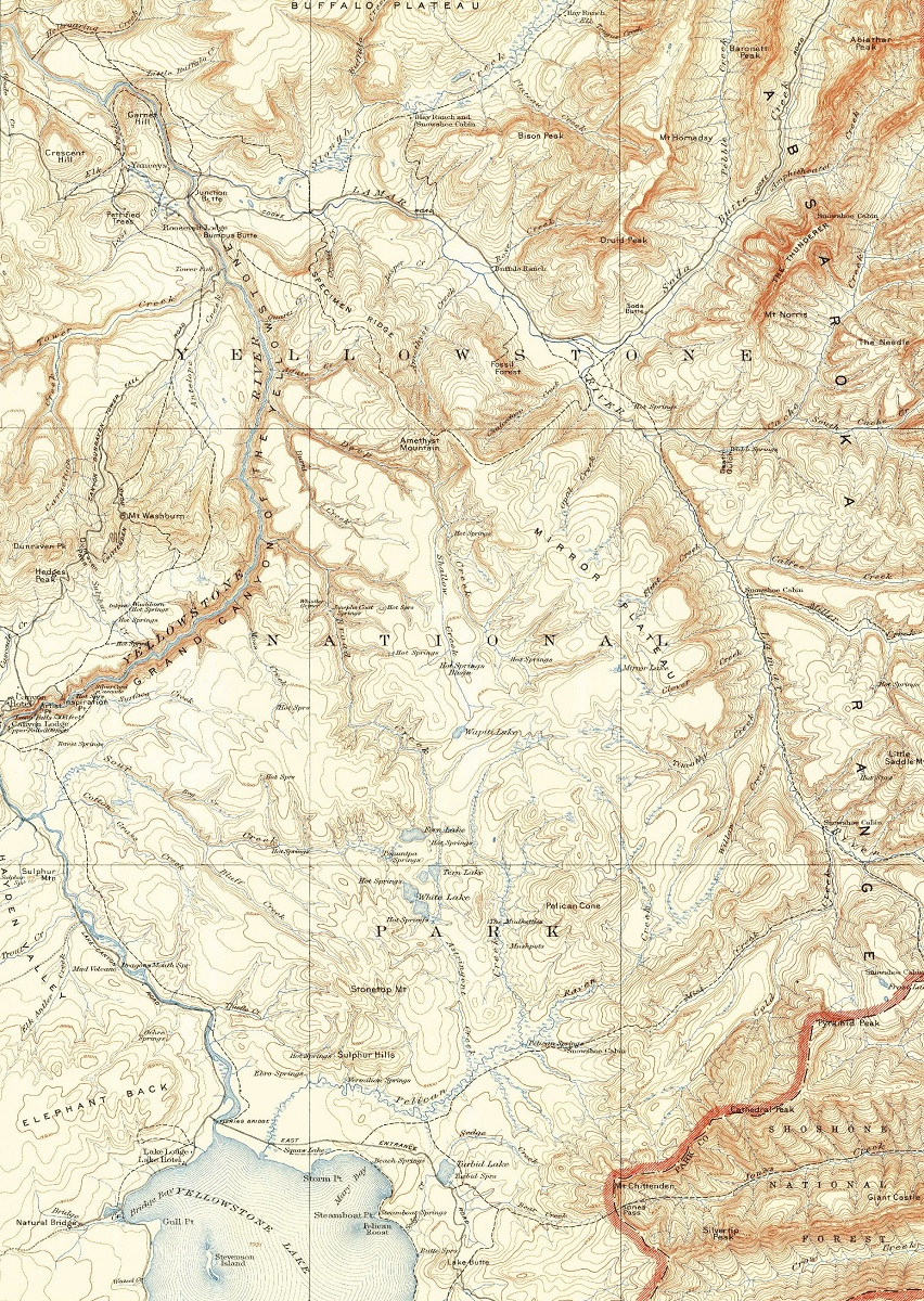
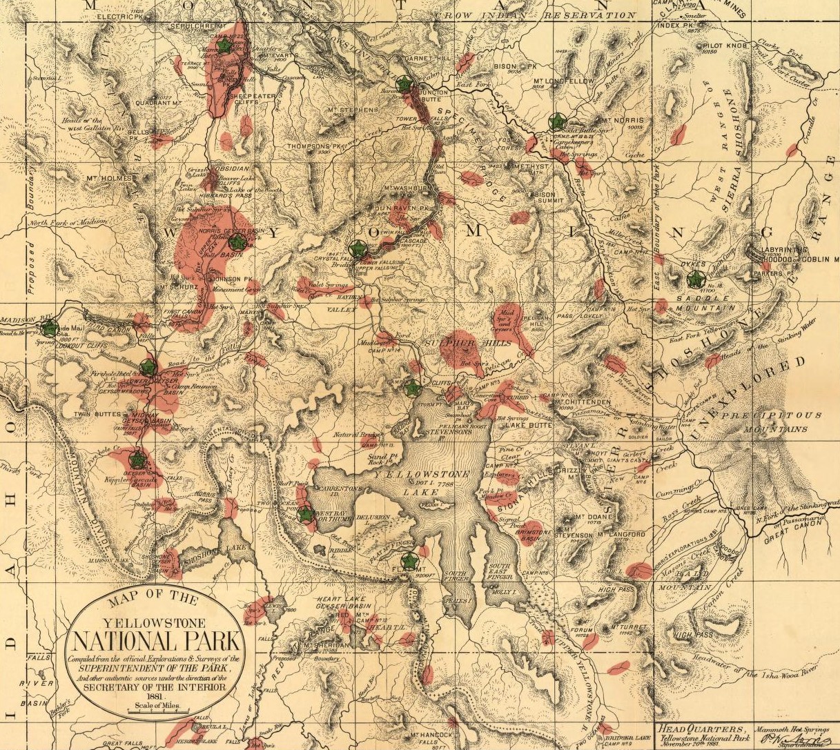
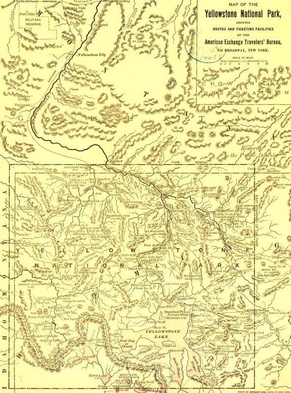
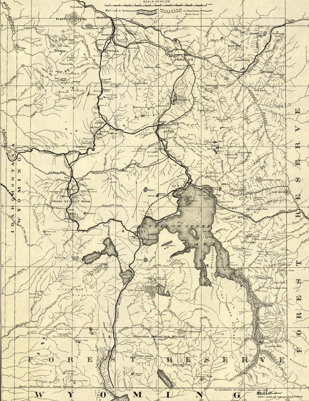
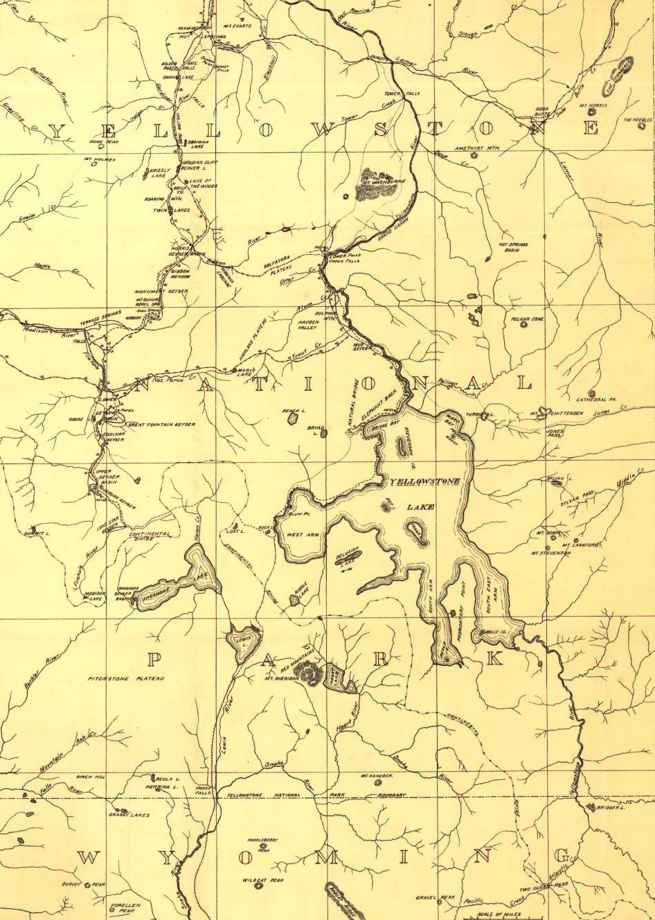
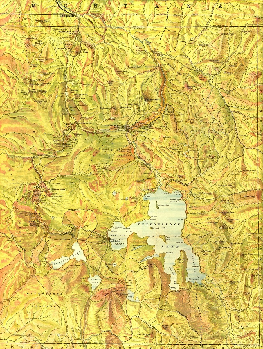
Yellowstone National Park Historical Maps
Yellowstone National Park has a rich and fascinating history, from its early use by Native American tribes to its establishment as the world’s first national park in 1872.
Historical maps are a type of map that depicts the historical features of a given area, including landmarks, routes, and other important features from the past. In Yellowstone, historical maps are particularly useful for visitors who want to learn more about the park’s rich history and how it has shaped the park’s unique landscapes.
- To learn how 2D/3D historical maps are built, click here: USGS Historical Maps
- Yellowstone National Park Historical Maps-Library of Congress
One of the most impressive historical maps available for Yellowstone is the Yellowstone National Park Historical Map. This map provides visitors with a comprehensive overview of the park’s history, including information on early explorers, the park’s establishment as a national park, and other important historical events. The map includes detailed depictions of the park’s many landmarks, as well as information on nearby hiking trails and other points of interest.
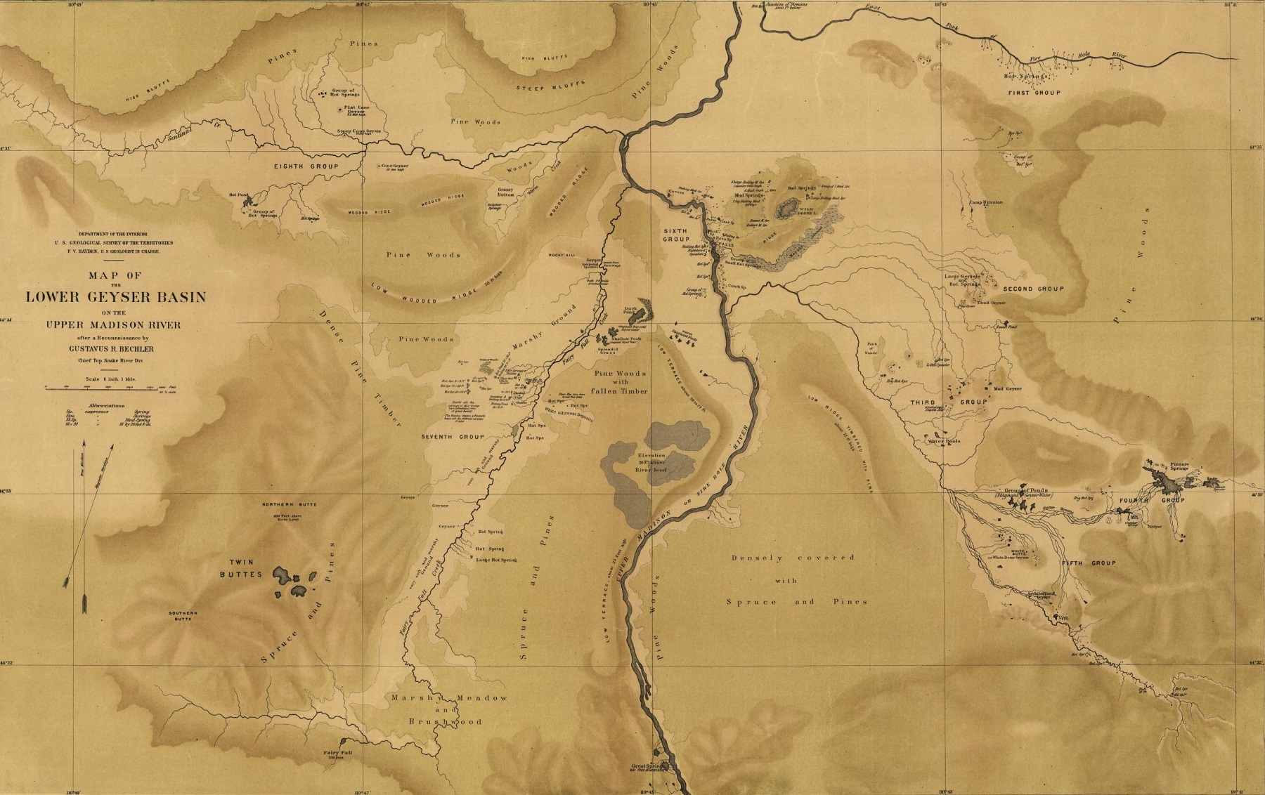
Another notable historical map available for Yellowstone is the Yellowstone Wagon Roads Historical Map. This map provides visitors with a detailed overview of the park’s wagon roads, which were an important transportation route in the park’s early history. The map includes detailed depictions of the park’s many wagon roads, as well as information on nearby historical landmarks and other points of interest.
Perhaps the most impressive aspect of historical maps is their ability to transport visitors back in time and help them appreciate the park’s rich history. By combining practical information with detailed maps, these historical maps can help visitors understand the park’s unique cultural heritage and how it has shaped the park’s landscapes over time.
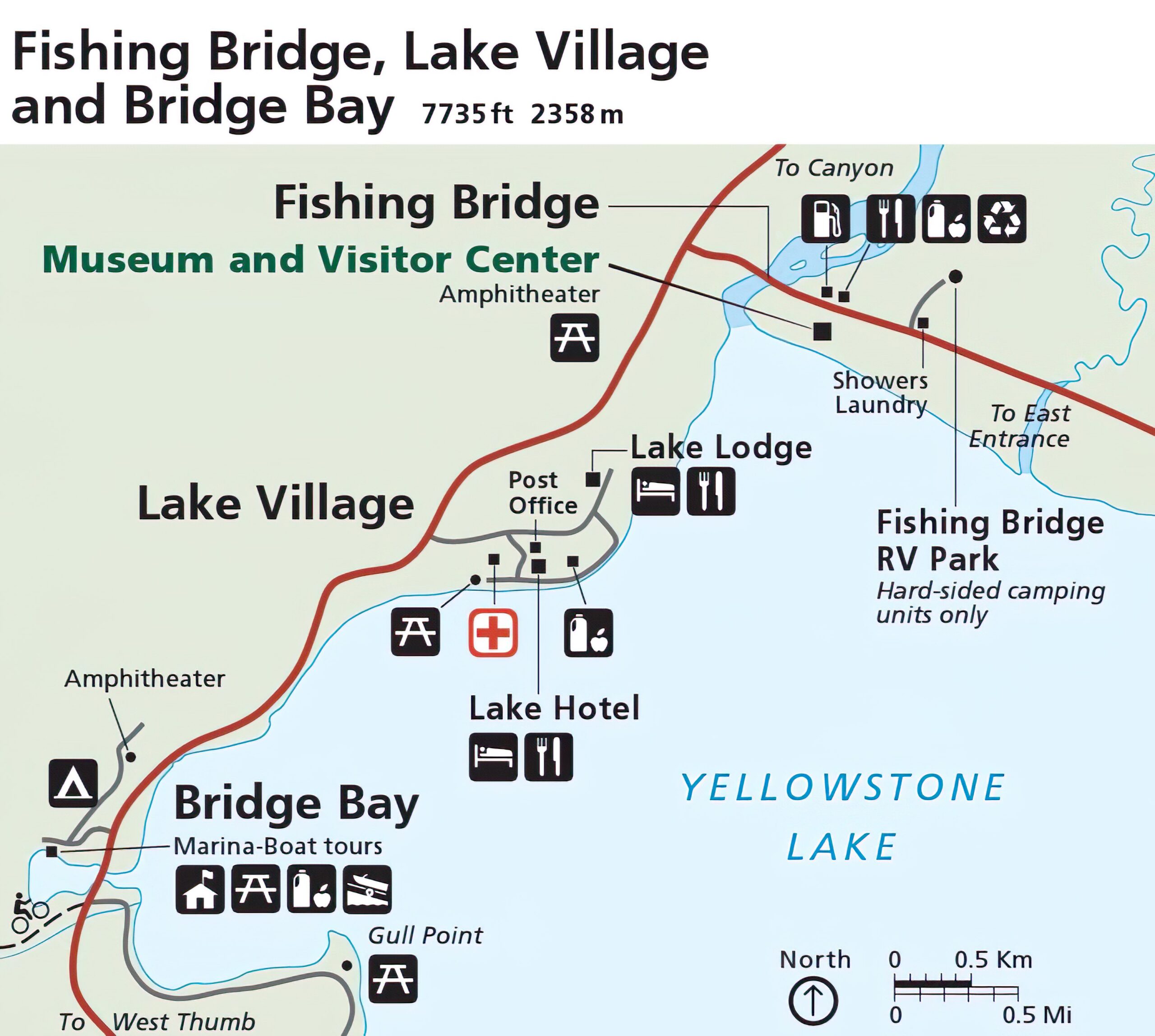
Yellowstone National Park Lodging Maps
Yellowstone National Park is a massive and awe-inspiring destination, with a vast array of lodging options to choose from. To help visitors find the perfect place to stay during their trip, Yellowstone lodging maps provide detailed information on the park’s many lodging options, including hotels, lodges, cabins, and campsites.
One of the most significant benefits of using Yellowstone lodging maps is their ability to help visitors choose the best lodging option based on their needs and preferences. These maps provide information on the location, amenities, and price range of each lodging option, allowing visitors to easily compare and select the option that best fits their budget and preferences.
- To learn how 2D/3D lodging maps are built, click here: Terrain Maps
- Yellowstone National Park-Plan Your Lodging
Yellowstone lodging maps also provide information on the location and availability of each lodging option, making it easy for visitors to plan their stay and make reservations in advance. This can be especially important during peak season when lodging options can book up quickly.
Another important benefit of using Yellowstone lodging maps is their ability to help visitors navigate the park and find their way to their chosen lodging option. These maps provide detailed information on the location and accessibility of each lodging option, allowing visitors to plan their route and find their way easily.
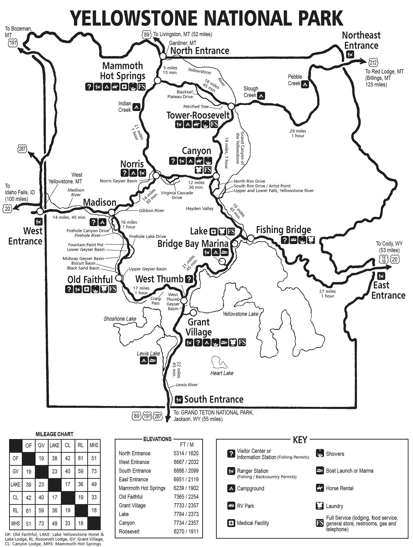
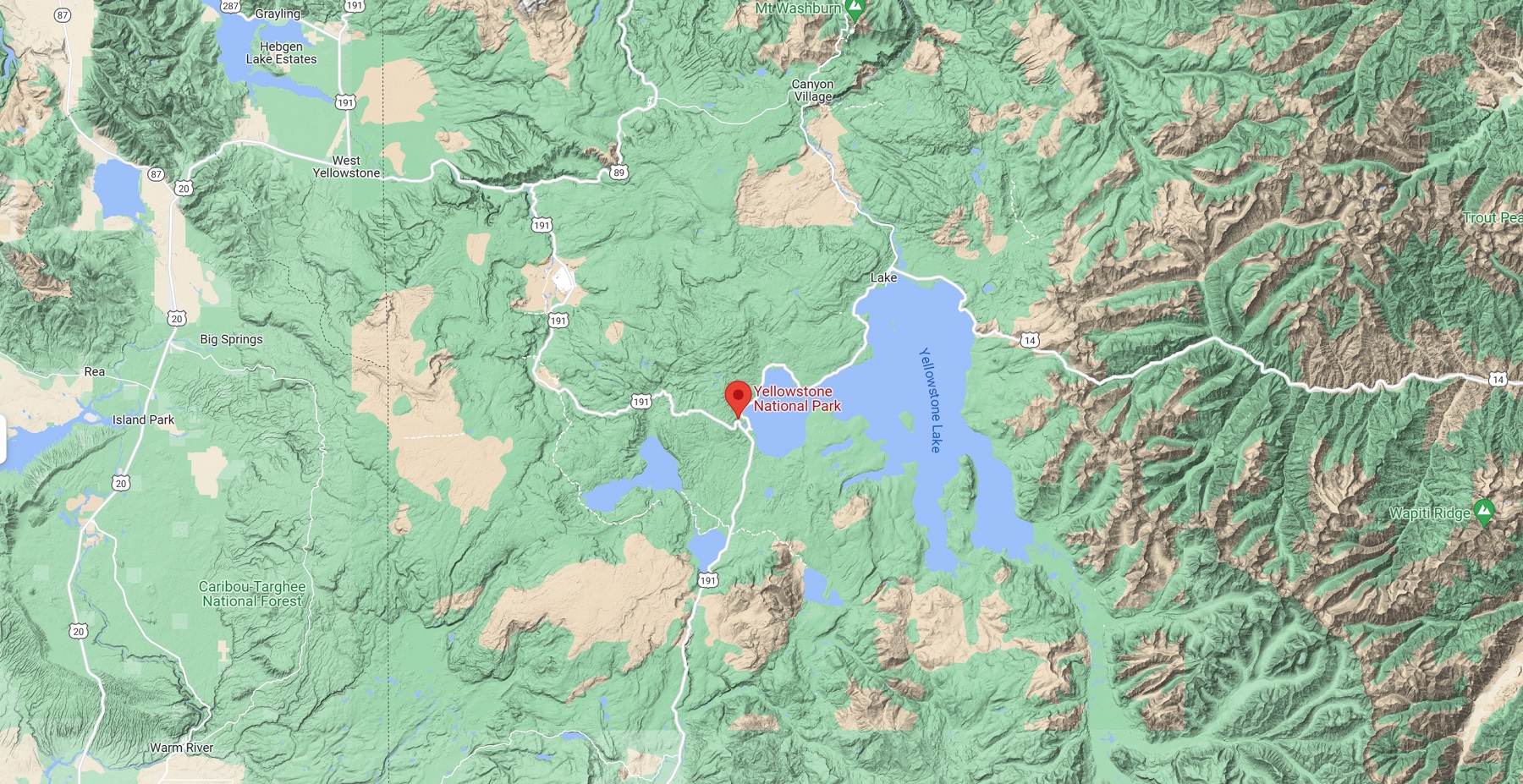
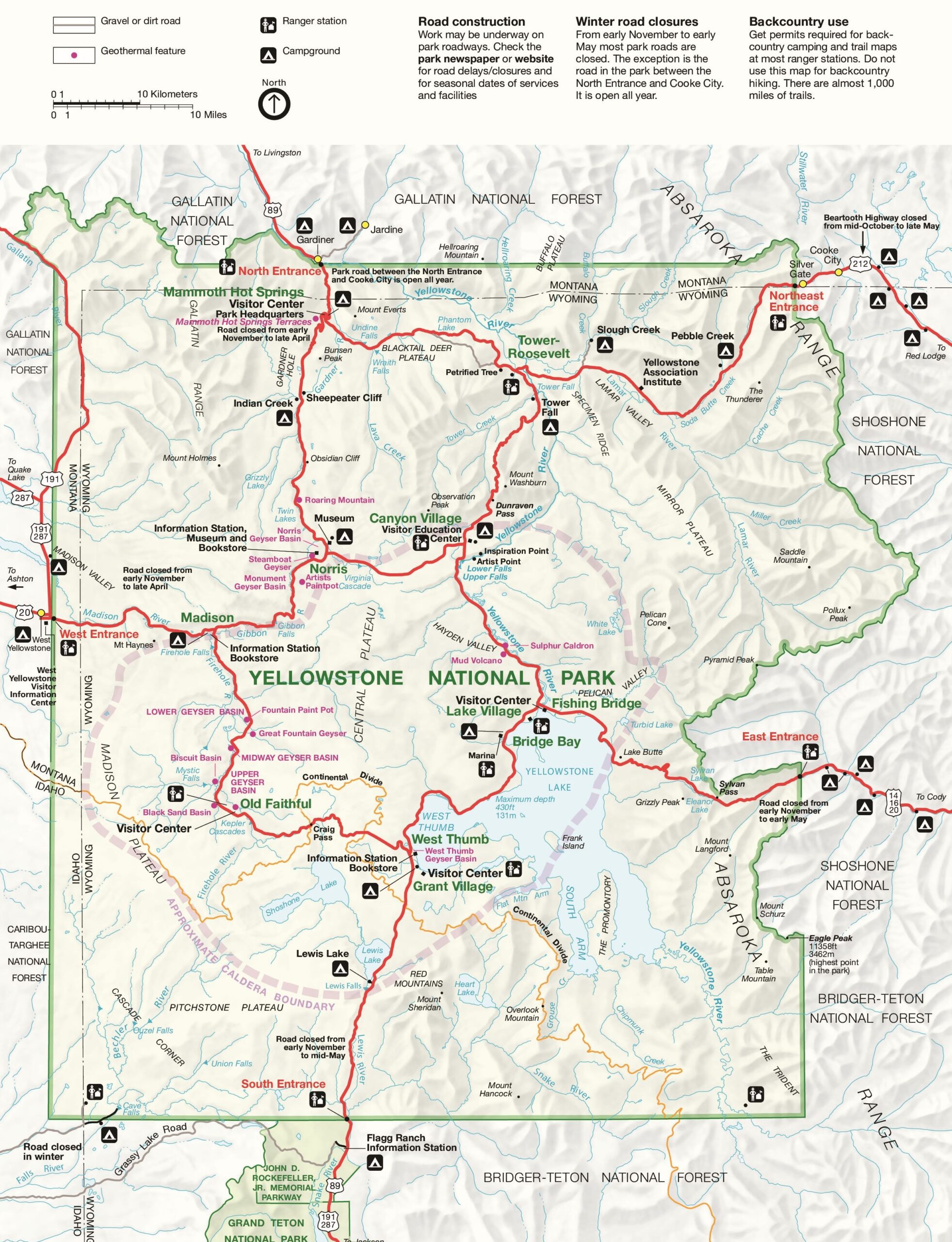
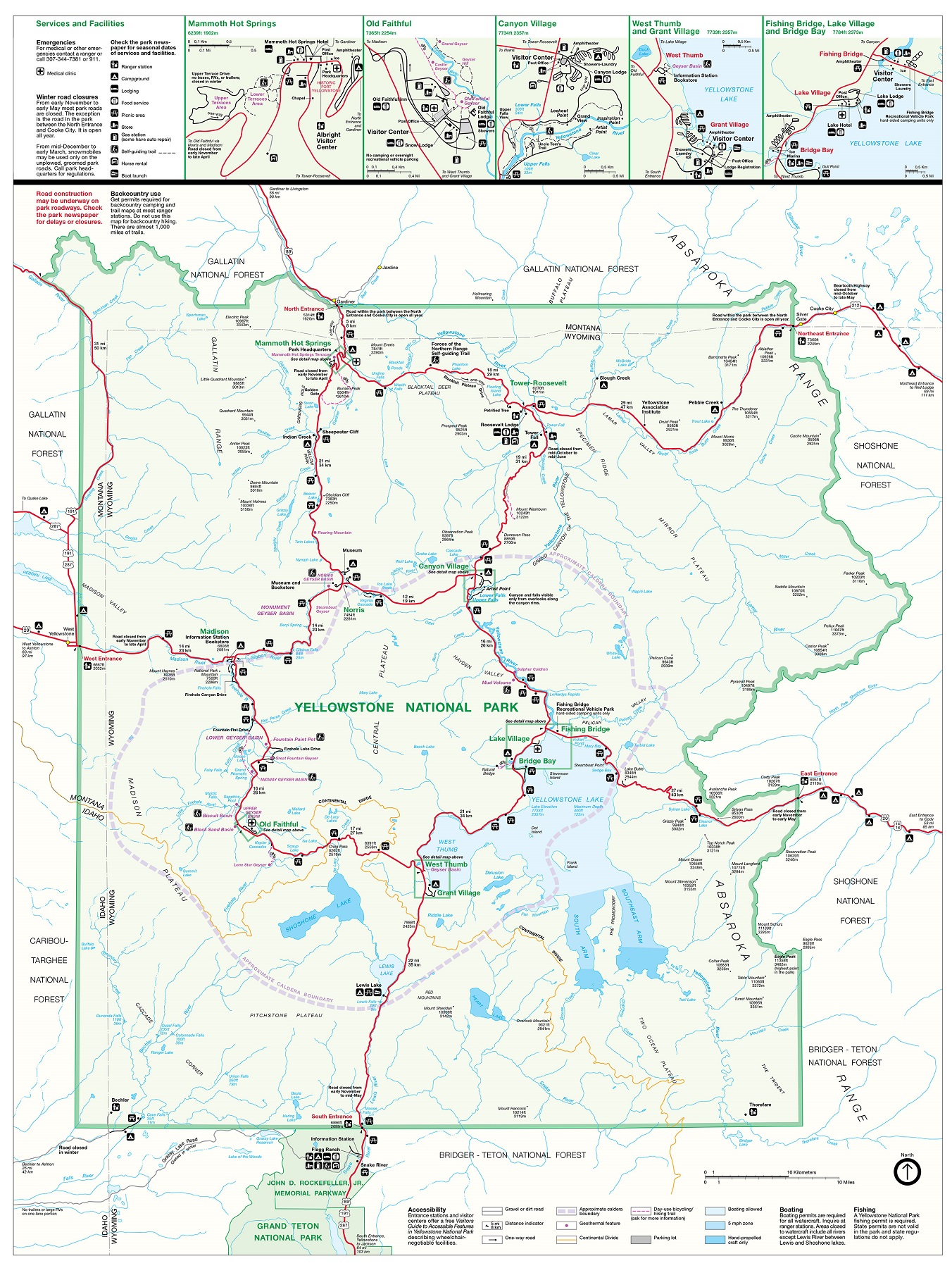
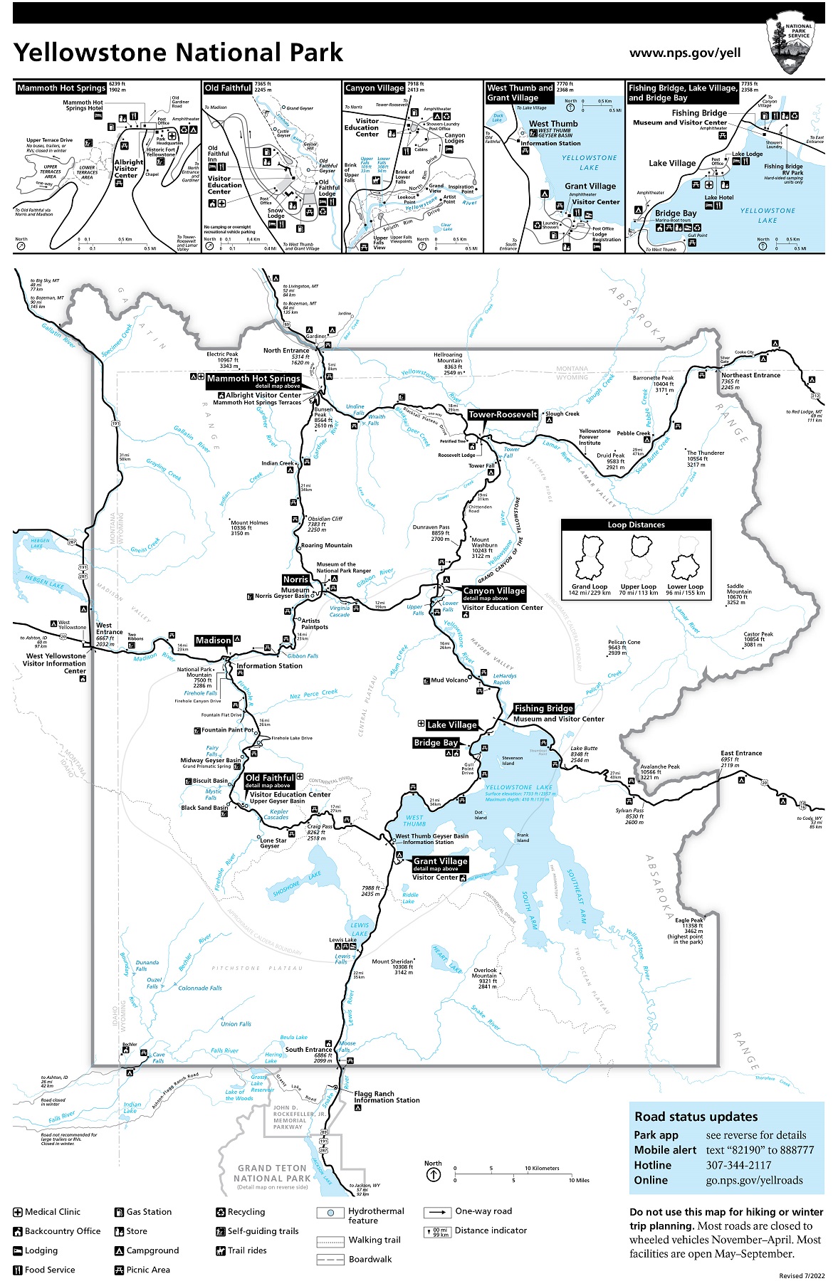
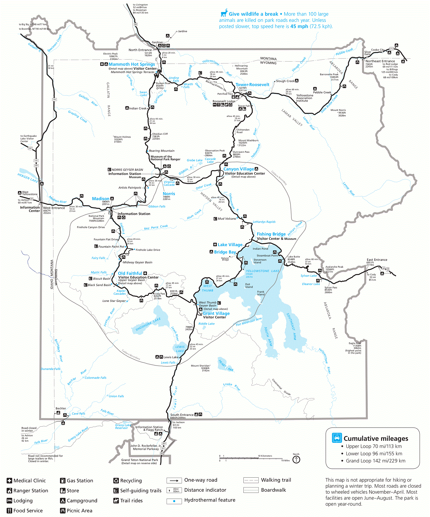
Yellowstone National Park Road Maps
Yellowstone National Park is an expansive and diverse destination that is best explored by car. To help visitors navigate the park’s many roads and highways, the park offers a variety of road maps.
Road maps are a type of map that provides detailed information on roads, highways, and other transportation routes in a given area. In Yellowstone, road maps are particularly useful for visitors who want to plan their travel routes, find the best scenic drives, and explore the park’s many attractions with ease.
- To learn how 2D/3D road maps are built, click here: Terrain Maps
- Yellowstone National Park-Plan Your Visit
- Yellowstone National Park-Official Park Road Map
One of the most impressive road maps available for Yellowstone is the Yellowstone National Park Road Map. This map provides visitors with a comprehensive overview of the park’s road network, including detailed depictions of the park’s many highways, roads, and other transportation routes. The map also includes information on nearby attractions, hiking trails, and other points of interest.
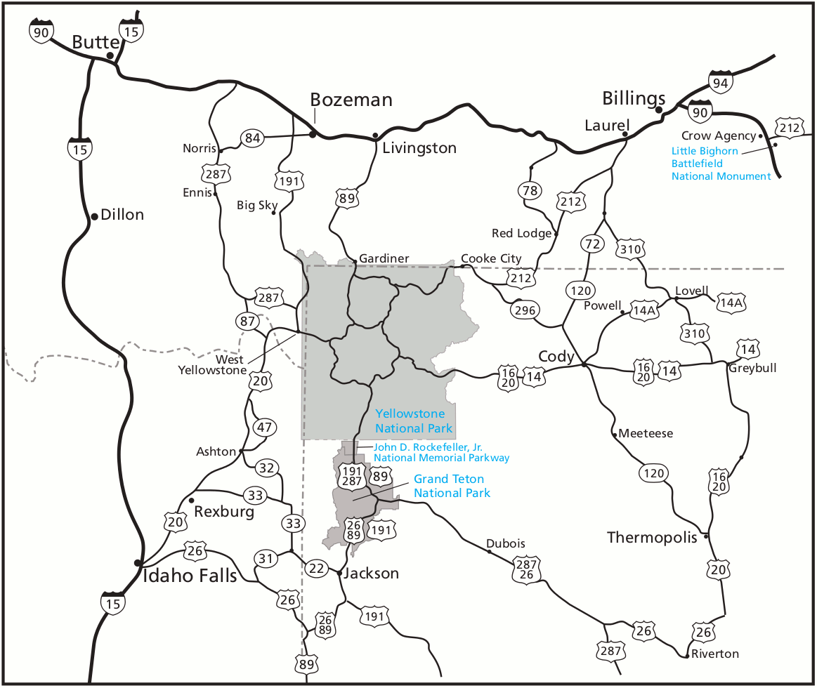
Another notable road map available for Yellowstone is the Yellowstone Scenic Byways Map. This map provides visitors with a detailed overview of the park’s most scenic drives, including the Beartooth Highway and the Chief Joseph Scenic Byway. The map includes information on nearby attractions, hiking trails, and other points of interest, making it the perfect tool for visitors who want to experience the park’s natural beauty from the comfort of their car.
Perhaps the most impressive aspect of road maps is their ability to help visitors plan their travel routes and make the most of their time in the park. By providing detailed information on the park’s many roads and highways, these maps can help visitors navigate the park’s expansive landscapes with ease.
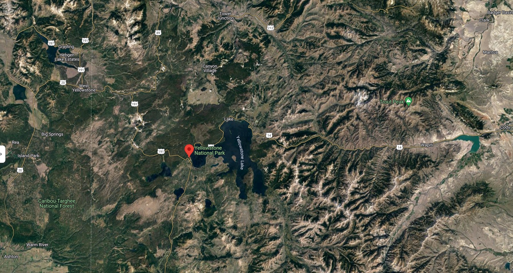
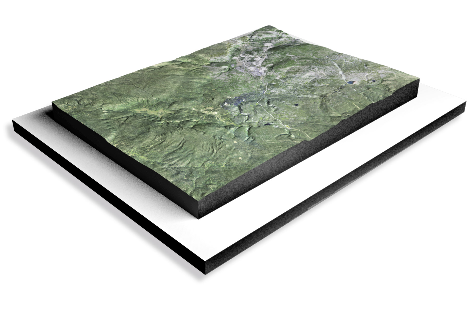
Yellowstone National Park Satellite Maps
Yellowstone National Park is one of the most beautiful and geologically diverse areas in the world. One way to fully appreciate its beauty and vastness is through the use of satellite maps.
Satellite maps are a type of map that uses satellite imagery to provide a detailed view of the Earth’s surface. In Yellowstone, satellite maps are particularly useful for visitors who want to explore the park’s vast and rugged terrain. These maps provide a bird’s-eye view of the park, allowing visitors to see the park’s many geological formations, mountain ranges, and waterways.
- To learn how 2D/3D satellite maps are built, click here: Satellite Maps
- Yellowstone National Park Satellite Maps-Canvas Prints
- Wyoming Satellite Maps-Canvas Prints
- Yellowstone National Park 3D Satellite Maps-3D Raised Relief
- Wyoming Satellite 3D Satellite Maps-3D Raised Relief
- Yellowstone National Park Satellite Maps-Google Maps
One of the most impressive satellite maps available for Yellowstone is the Google Earth Yellowstone map. This map provides visitors with a 3D view of the park, allowing them to explore its many features in great detail. Visitors can zoom in on specific areas of the park and view it from any angle, making it the perfect tool for those who want to explore Yellowstone’s many hiking trails, hot springs, and other natural wonders.
Another notable satellite map available for Yellowstone is the NASA Landsat satellite map. This map provides visitors with a more scientific view of the park, showing them how the park’s landscapes have changed over time. The map allows visitors to compare images of the park from different years, giving them a unique perspective on the park’s geology and ecology.
Perhaps the most impressive aspect of satellite maps is their ability to show visitors the park’s incredible size and scale. By providing a bird’s-eye view of the park, these maps can help visitors appreciate the park’s vastness and the incredible geological forces that shaped it.
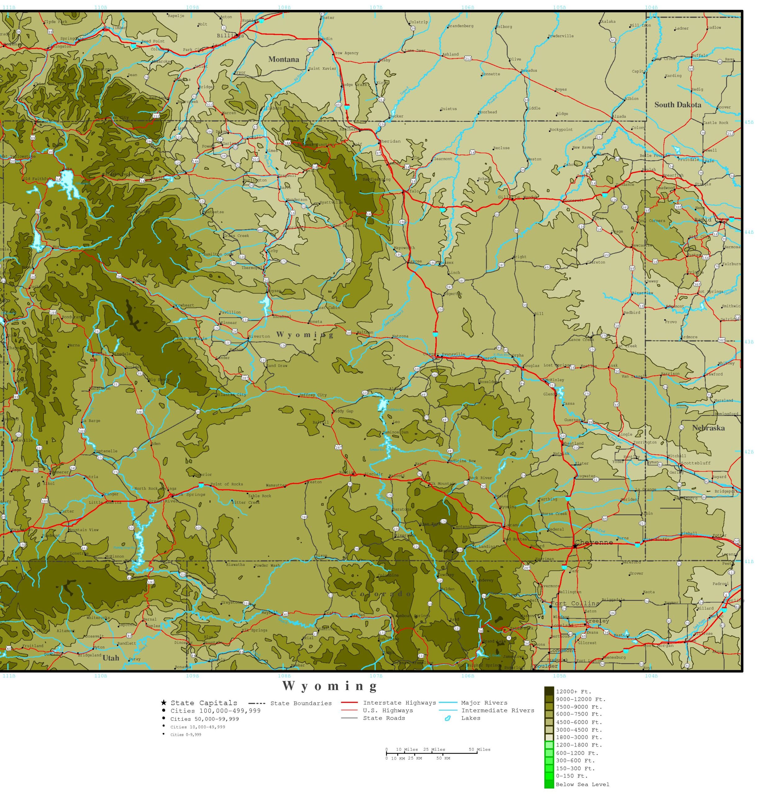
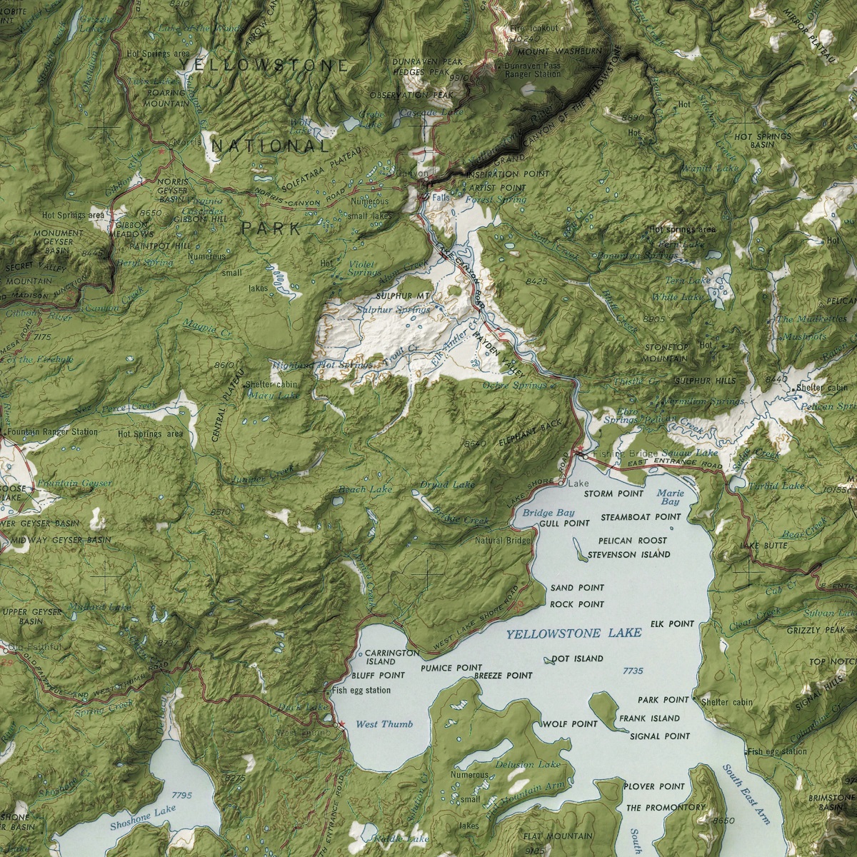
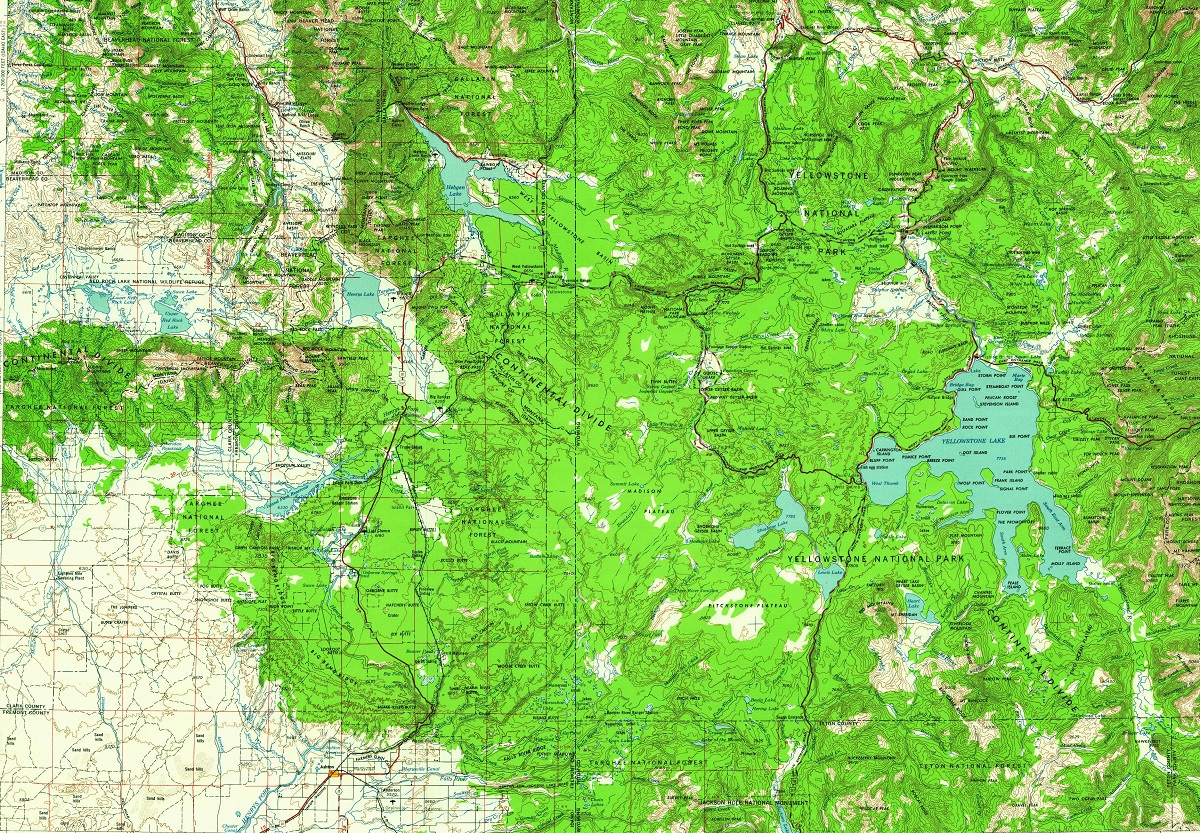
Yellowstone National Park Terrain Maps
Yellowstone National Park is home to some of the most rugged and diverse terrain in the world. From towering mountains and deep valleys to winding rivers and vast meadows, the park’s terrain is as varied as it is beautiful.
Terrain maps are a type of map that shows the physical characteristics of the Earth’s surface, including its elevation, slope, and topography. In Yellowstone, terrain maps are particularly useful for visitors who want to explore the park’s many hiking trails and natural wonders. These maps provide a detailed view of the park’s terrain, allowing visitors to plan their trips and navigate the park’s rugged terrain.
- To learn how 2D/3D terrain maps are built, click here: Terrain Maps
- Yellowstone National Park Terrain Maps-Canvas Prints
- Wyoming Terrain Maps-Canvas Prints
- Yellowstone National Park 3D Terrain Maps-3D Raised Relief
- Wyoming 3D Terrain Maps-3D Raised Relief
- Yellowstone National Park Terrain Maps-Google Maps
One of the most impressive terrain maps available for Yellowstone is the National Geographic Yellowstone Trails Illustrated Map. This map provides visitors with a detailed view of the park’s terrain, including its many mountains, valleys, and rivers. The map also includes information on the park’s hiking trails, backcountry campsites, and other natural features, making it the perfect tool for visitors who want to explore Yellowstone on foot.
Another notable terrain map available for Yellowstone is the USGS Yellowstone topographic map. This map provides visitors with a more scientific view of the park’s terrain, showing them the park’s elevation, slope, and other physical characteristics in great detail. The map allows visitors to plan their trips and explore the park’s natural wonders with greater accuracy and precision.
Perhaps the most impressive aspect of terrain maps is their ability to show visitors the park’s incredible diversity. By providing a detailed view of the park’s terrain, these maps can help visitors appreciate the park’s vastness and the incredible geological forces that shaped it.
Yellowstone National Park Trail Maps
Yellowstone National Park is a vast wilderness area that covers over 2 million acres of land. With such a vast expanse of wilderness to explore, it can be challenging for visitors to know where to start. That’s where trail maps come in handy.
Yellowstone trail maps provide visitors with a comprehensive view of the park’s hiking trails, backcountry campsites, and natural features. These maps are an invaluable tool for planning a hiking or backpacking trip in Yellowstone, as they can help visitors navigate the park’s many trails and plan a route that suits their interests and abilities.
- To learn how 2D/3D trail maps are built, click here: Terrain Maps
- Yellowstone National Park-Plan Your Visit
One of the most significant benefits of using Yellowstone trail maps is their ability to help visitors discover hidden gems within the park. With so many trails to choose from, it can be easy to stick to the most popular routes and miss out on some of the park’s lesser-known hiking trails and natural wonders. Trail maps can help visitors plan a route that takes them off the beaten path and allows them to explore some of the park’s hidden gems.
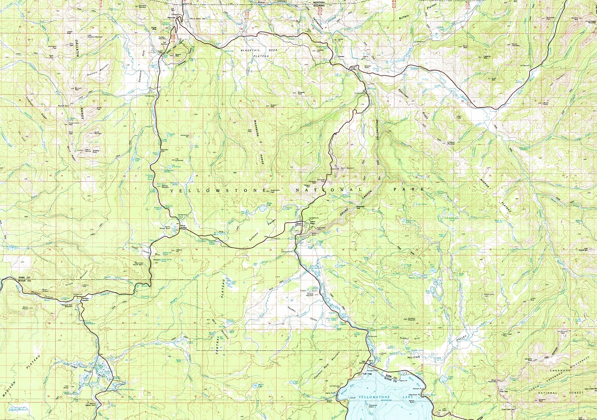
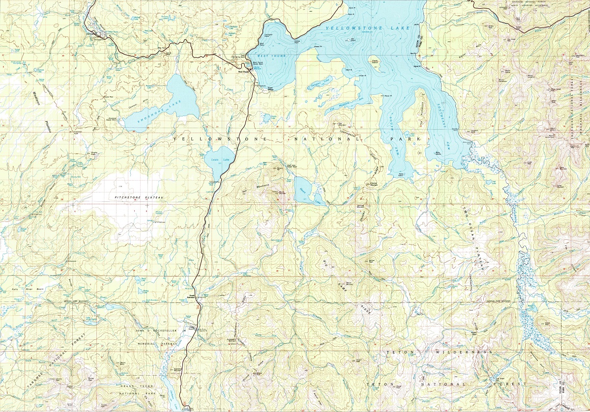
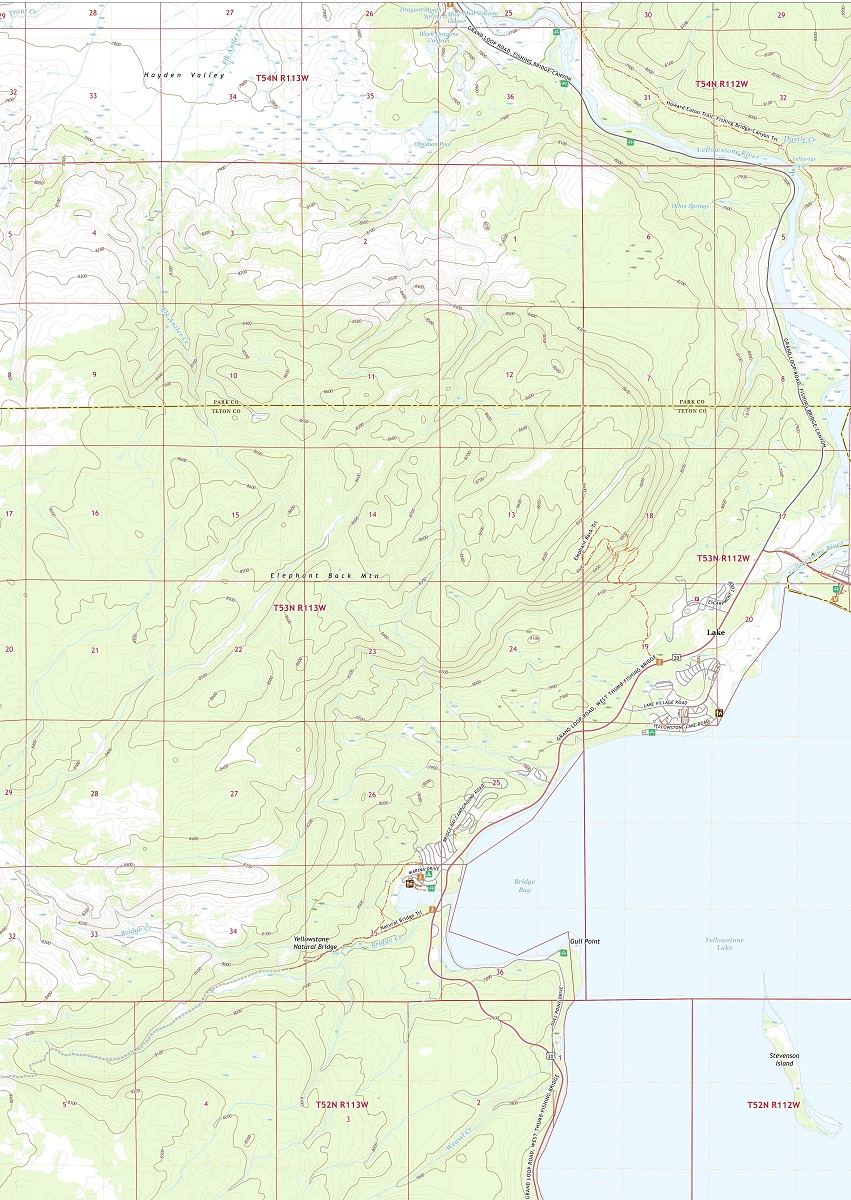
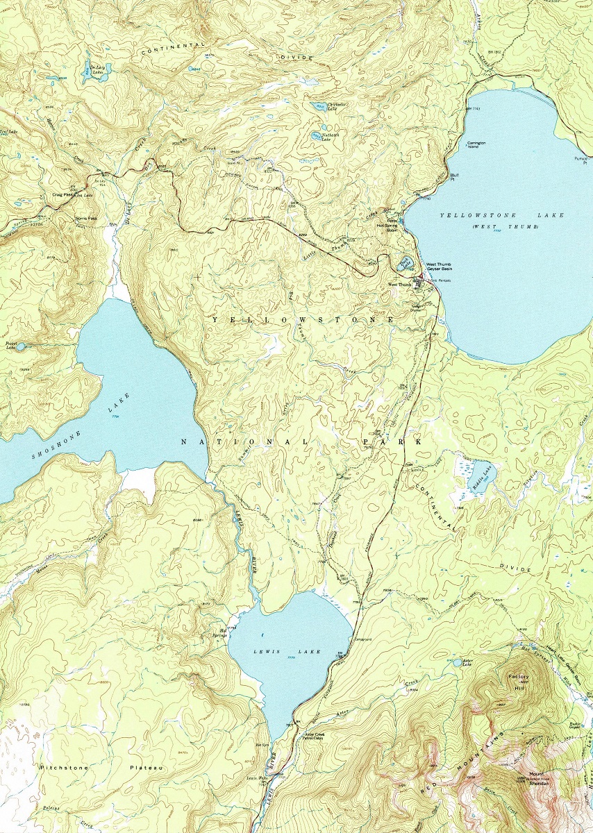
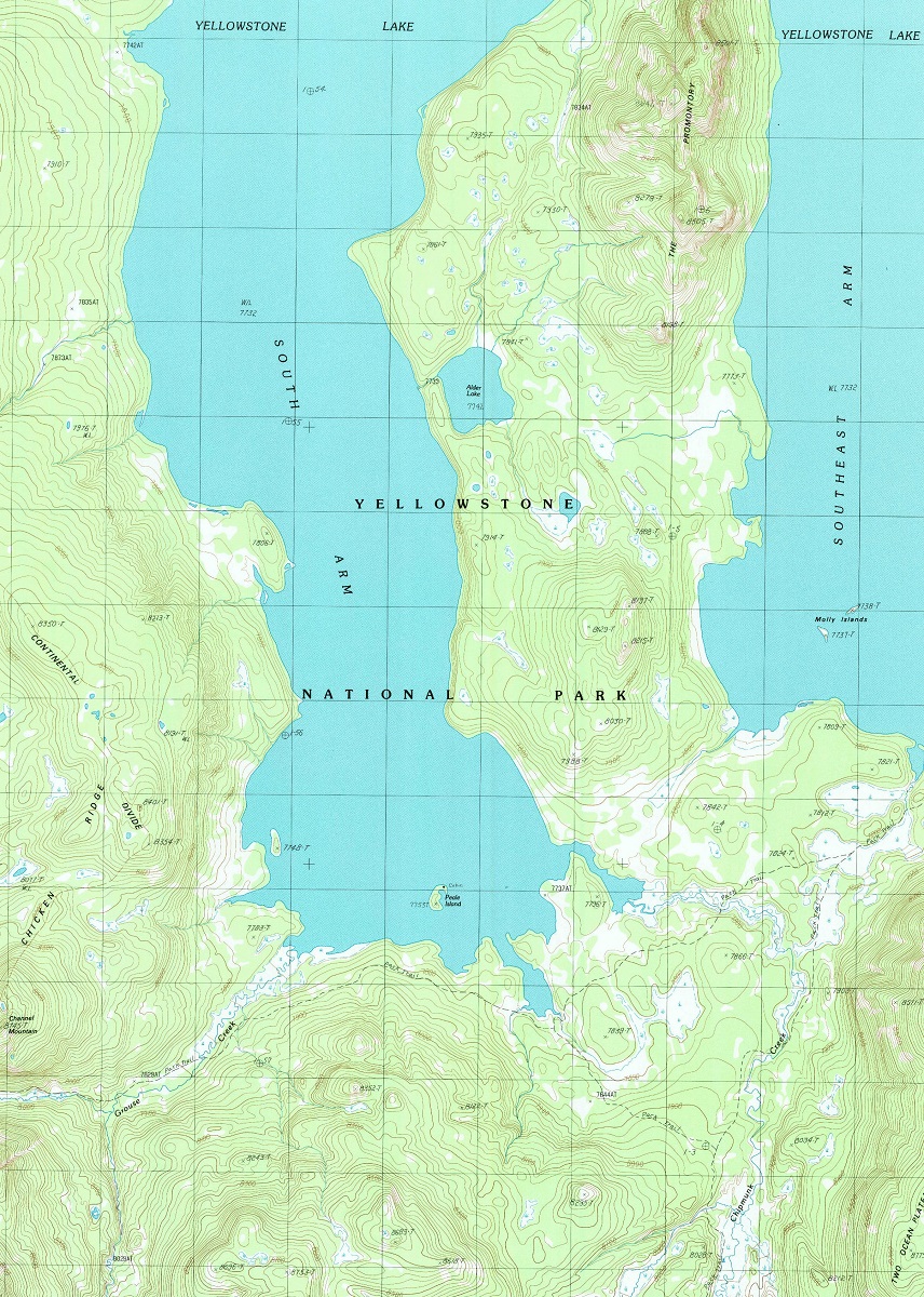
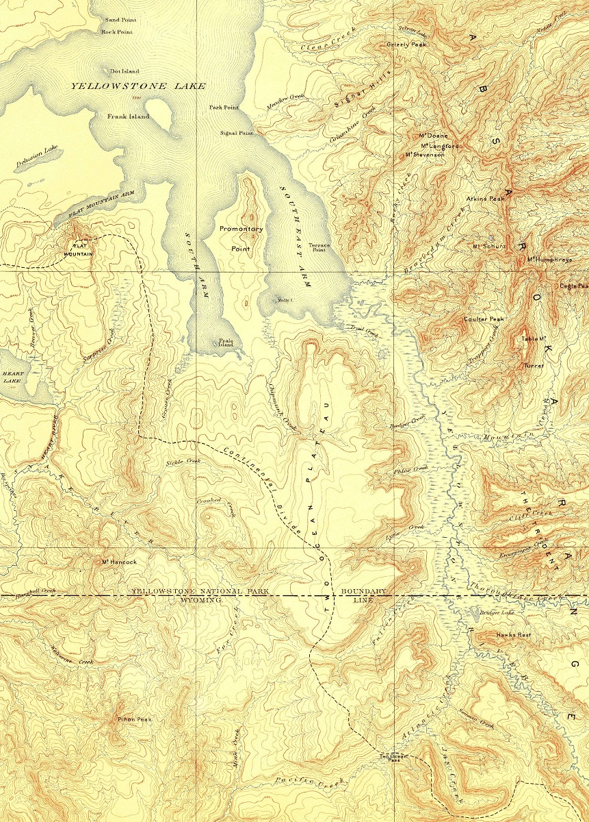
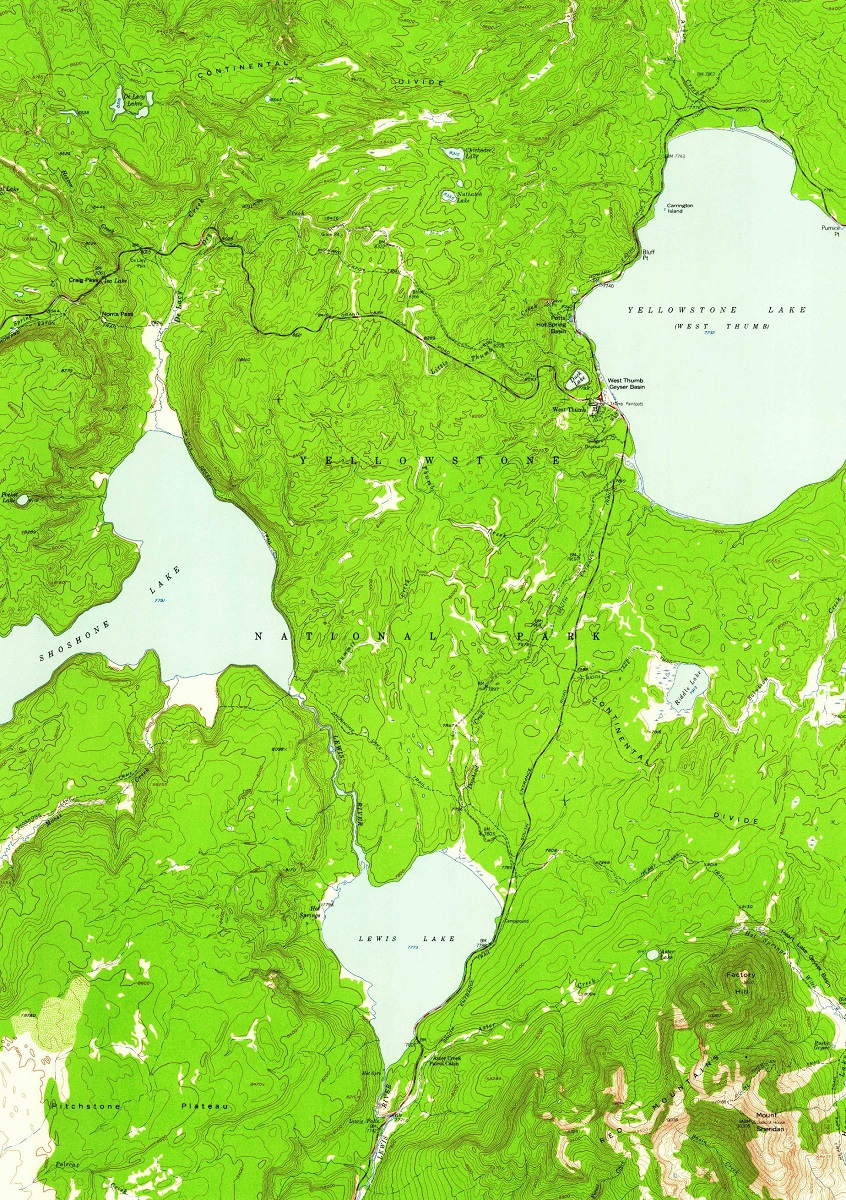
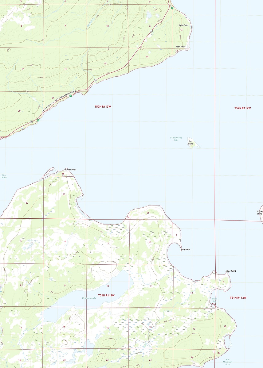
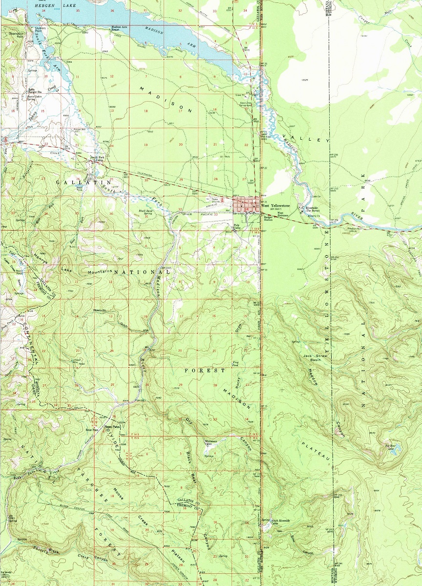
Yellowstone National Park USGS Maps
Yellowstone National Park is one of the most beautiful and unique places in the United States, home to an incredible array of geothermal features, wildlife, and natural wonders. To fully appreciate all that the park has to offer, visitors should consider using USGS maps, which provide detailed information on the park’s geology, topography, and other important features.
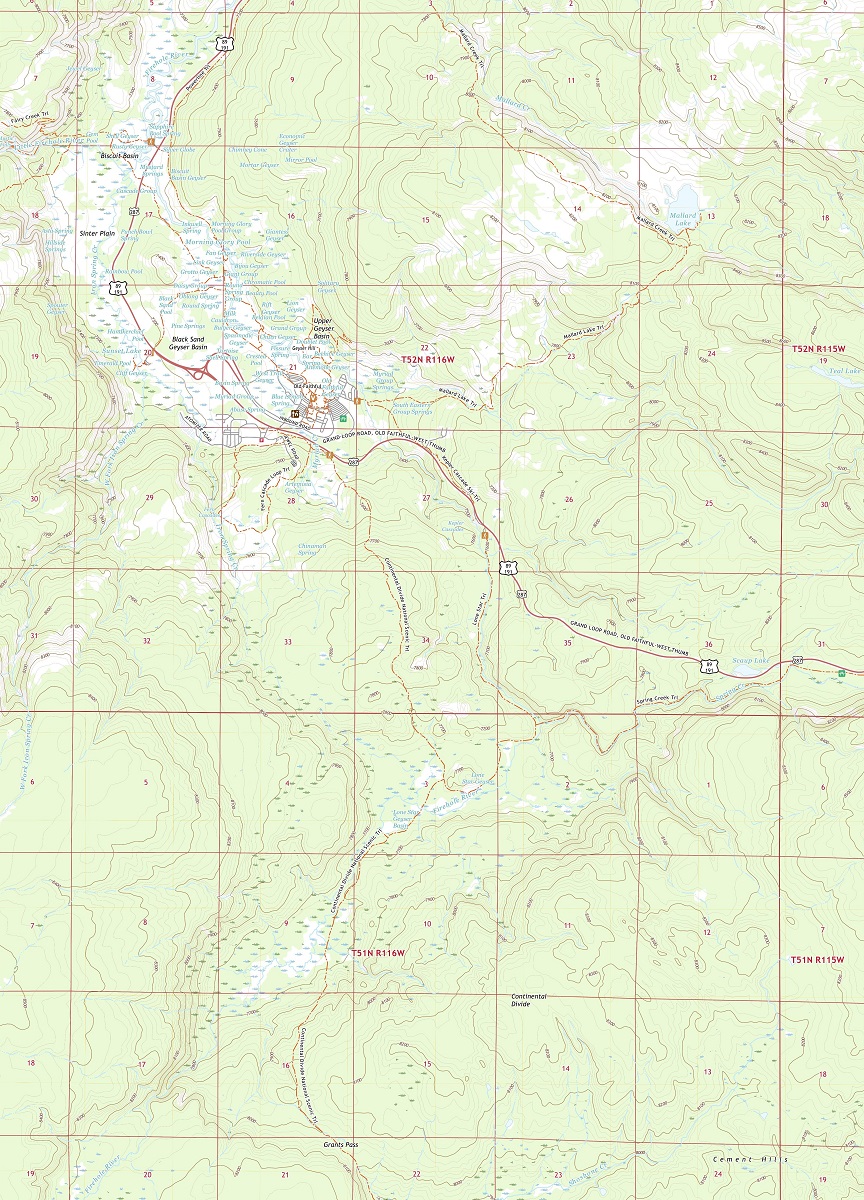
USGS maps are created by the United States Geological Survey, an agency responsible for mapping the country’s natural resources, hazards, and environmental health. In the case of Yellowstone National Park, USGS maps provide detailed information on the park’s geology, topography, hydrology, and more.
USGS maps are divided into quadrangles, each covering an area of 7.5 minutes of longitude and latitude. Each map provides detailed information on topography, including elevation contours, water features, and vegetation types. The maps also include roads, buildings, and other landmarks, allowing users to navigate and explore the landscape with precision.
- To learn how 2D/3D USGS maps are built, click here: USGS Maps and USGS Historical Maps
- Yellowstone National Park USGS Maps-Canvas Prints
- Wyoming USGS Maps-Canvas Prints
- Yellowstone National Park 3D USGS Maps-3D Raised Relief
- Wyoming 3D USGS Maps-3D Raised Relief
- Wyoming USGS Historical Topo 3D Maps by Cities-3D Raised Relief
Historical USGS maps of Yellowstone are also available and provide a fascinating glimpse into the area’s past. These maps were produced using traditional cartographic techniques, including photolithography and offset printing.
Yellowstone Historical USGS maps are valuable for a range of applications, including historical research, environmental assessment, and land use planning. They can provide information on changes in land use, including deforestation, urbanization, and agricultural development. They can also provide information on the natural features of the landscape, including wetlands, rivers, and other water bodies.

One of the most significant benefits of using Yellowstone USGS maps is their ability to help visitors understand the park’s unique geothermal features. Yellowstone is home to more than 10,000 hydrothermal features, including geysers, hot springs, mud pots, and fumaroles. USGS maps provide visitors with detailed information on the locations, names, and characteristics of these features, allowing them to better understand the park’s geological history and appreciate its natural beauty.
Another important benefit of using Yellowstone USGS maps is their ability to help visitors navigate the park’s many trails and backcountry areas. These maps provide information on trail locations, distances, elevations, and terrain, allowing visitors to plan their hikes and other outdoor activities safely and efficiently.
Yellowstone National Park Weather Maps
Yellowstone National Park is known for its dramatic landscapes, stunning natural features, and diverse wildlife. However, it is also notorious for its unpredictable and often severe weather.
Yellowstone weather maps provide visitors with up-to-date information on weather conditions in the park, including temperature, wind speed, precipitation, and more. These maps are an essential tool for planning a trip to Yellowstone, as they can help visitors prepare for the often-changing weather conditions that can occur in the park.
These maps are created and maintained by various government agencies, including the National Weather Service (NWS) and the National Oceanic and Atmospheric Administration (NOAA).
- To learn how 2D/3D weather maps are built, click here: NOAA Maps
- Yellowstone Current Weather Maps: National Park Service
- Yellowstone National Weather Service Forecast Maps
- Yellowstone Accuweather Maps
- Yellowstone Weather Forecast Maps
One of the most significant benefits of using Yellowstone weather maps is their ability to help visitors stay safe during their trip. Weather conditions in Yellowstone can change rapidly, and severe weather events such as lightning storms, blizzards, and flash floods can occur without warning. Weather maps can help visitors plan their activities around the weather and avoid potentially dangerous situations.
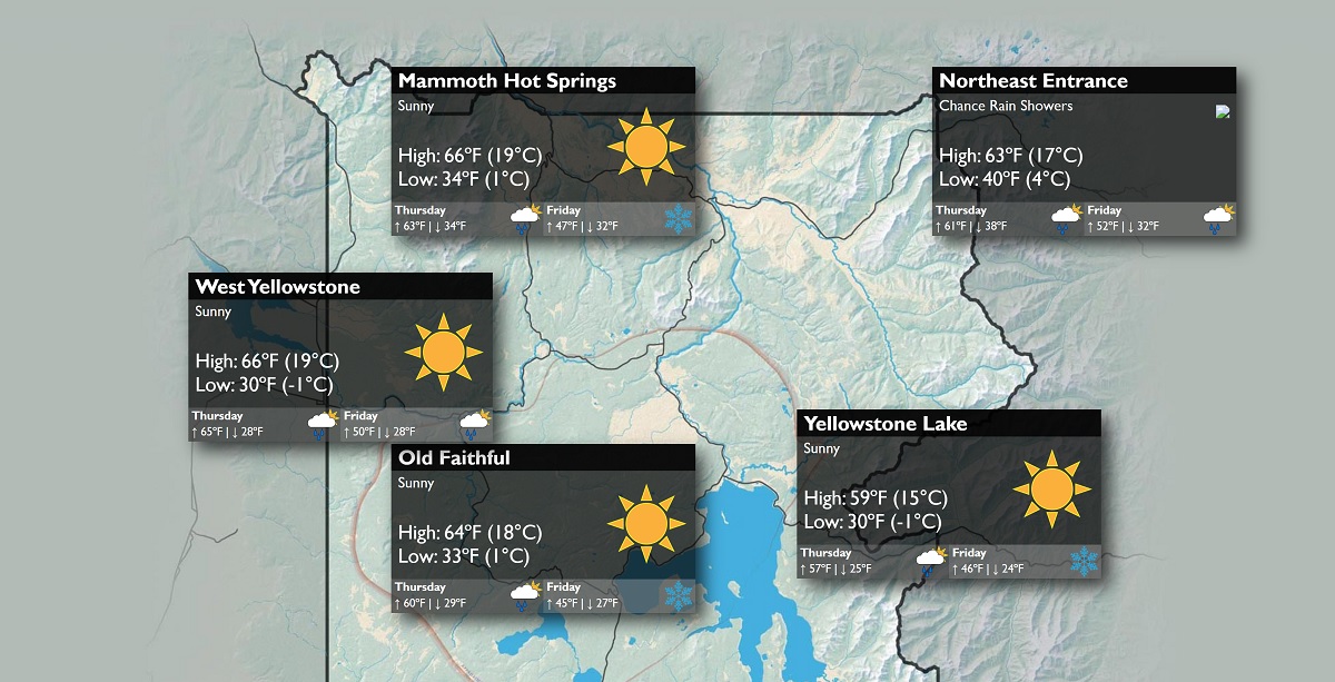
Another notable benefit of using Yellowstone weather maps is their ability to help visitors make the most of their trip. Weather conditions can have a significant impact on the park’s natural features, and knowing when and where to go can make all the difference in experiencing Yellowstone’s unique beauty. For example, a sunny day can bring out the vibrant colors of the park’s geothermal features, while a foggy morning can create a mystical atmosphere in the forests and valleys.
Yellowstone weather maps can be accessed through a variety of sources, including the National Park Service website, local weather stations, and weather apps such as AccuWeather and Weather Underground. These maps provide visitors with real-time data on weather conditions in the park, allowing them to make informed decisions about their activities and travel plans.
Yellowstone National Park Wildlife Maps
Yellowstone National Park is a sanctuary for a diverse range of wildlife species. With over 67 species of mammals, including grizzly bears, wolves, bison, elk, and more, it’s no wonder that the park is considered one of the best wildlife viewing destinations in the world. Yellowstone wildlife maps are an essential tool for anyone looking to explore the park’s incredible wildlife and experience the wonders of the natural world.
Yellowstone wildlife maps provide detailed information on the park’s different wildlife viewing areas, as well as the different species visitors can expect to see. These maps also provide information on the best times of day to view specific animals and where to find them, ensuring visitors have the best possible chance of seeing these incredible creatures in their natural habitat.
- To learn how 2D/3D wildlife maps are built, click here: Terrain Maps
- Yellowstone National Park-Watch Wildlife
One of the most iconic animals in Yellowstone is the bison, which can often be seen grazing on the park’s grasslands. Yellowstone wildlife maps provide information on the best areas to view bison, including the Lamar Valley, Hayden Valley, and the central plateau. These maps also provide information on the best times of day to view these magnificent animals, which are most active in the early morning and late afternoon.
Another iconic Yellowstone animal is the grizzly bear, which can be found in several areas of the park, including the Lamar Valley and the surrounding mountain ranges. Visitors are advised to keep a safe distance from these powerful animals and to follow all park regulations to ensure both their own safety and the safety of the bears.
These wildlife maps also provide information on the park’s wolf populations, which were reintroduced to the park in the 1990s after a decades-long absence. Visitors can often see these majestic animals in the Lamar Valley, as well as other areas of the park.


