

Are you ready to embark on a thrilling journey through the mesmerizing wilderness of Yellowstone National Park? Spanning over 2.2 million acres, this vast and breathtaking expanse is a paradise for outdoor enthusiasts and nature lovers. With its diverse terrain, geothermal wonders, and enchanting wildlife, Yellowstone offers an experience like no other. But, to truly make the most of your visit, you need a reliable guide. That’s why we present to you the Ultimate Guide to Maps of Yellowstone. Here, we’ll take you on an exhilarating ride through the various types of maps available and show you how they can elevate your adventure in this spectacular national park. So, get ready to explore Yellowstone like never before!
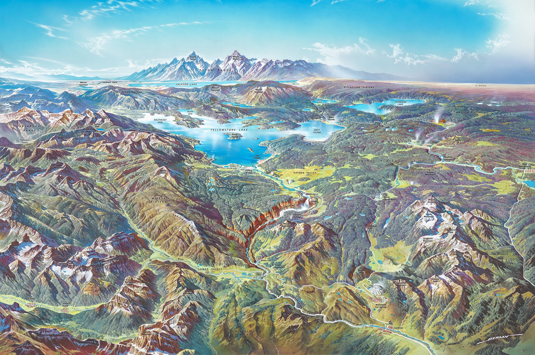
3D Maps
One of the most exciting and immersive ways to explore Yellowstone is through a 3D map. These maps provide a realistic, three-dimensional view of the park’s terrain and features, allowing you to visualize the landscape in a way that traditional maps can’t. The National Park Service offers a 3D map of Yellowstone that you can access online, which is a great way to get a sense of the park’s layout and topography before you arrive.
Backcountry Maps
For those looking to explore Yellowstone’s remote and less-traveled areas, a backcountry map is essential. These maps show the park’s hiking trails, campsites, and other features that are important to backcountry travelers. They also provide valuable information about the park’s regulations and safety guidelines. You can purchase a backcountry map of Yellowstone at any of the park’s visitor centers or online.
Brochure Maps
Brochure maps are a popular and convenient way to get an overview of Yellowstone’s main attractions and facilities. These maps are often available at the park’s entrance stations, visitor centers, and other locations throughout the park. They provide an easy-to-read layout of the park’s roads, trails, campgrounds, and other amenities.
Campground Maps
If you’re planning to camp in Yellowstone, a campground map is a must-have. These maps show the locations of all the park’s campgrounds and provide information about their facilities, including restroom and shower facilities, water availability, and RV hookups. You can find campground maps at the park’s visitor centers or at Yellowstone Maps.
Geologic Maps
Yellowstone is known for its unique geothermal features, including hot springs, geysers, and mudpots. A geologic map can help you understand the park’s geology and how it relates to its natural features. These maps provide information about the park’s rocks, minerals, and geologic structures and can be a fascinating way to explore Yellowstone’s natural wonders.
Historical Maps
Yellowstone has a rich history that dates back thousands of years. Historical maps can provide a glimpse into the park’s past, including its early explorers, Native American history, and the development of the park’s infrastructure. The National Park Service offers a collection of historical maps online that can help you explore the park’s rich history.
Lodging Maps
If you’re planning to stay in one of Yellowstone’s many lodges, a lodging map can help you navigate the park’s accommodations. These maps show the locations of the park’s lodges, as well as their amenities and services.
Road Maps
Yellowstone’s extensive road network can be confusing, especially if you’re not familiar with the park’s layout. A road map can help you navigate the park’s highways and byways, including the park’s famous figure-eight loop road. These maps also provide information about road conditions, construction, and closures, which can be valuable when planning your trip.
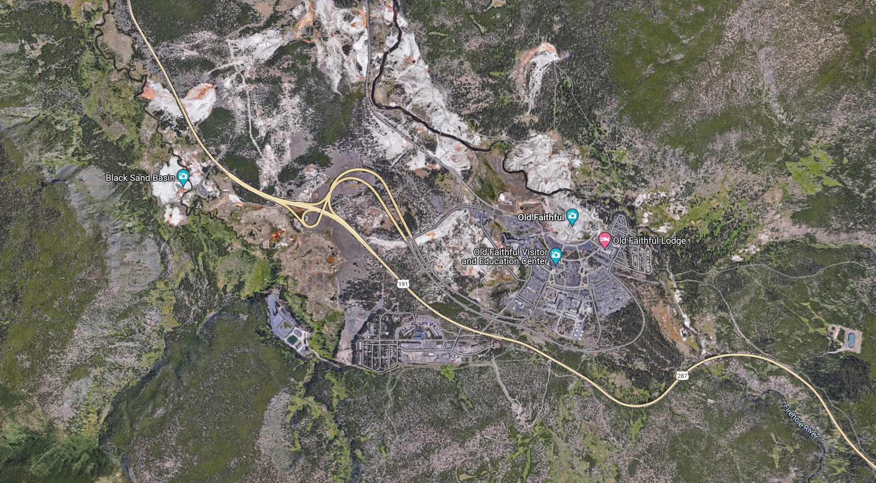
Satellite Maps
Satellite maps provide a bird’s-eye view of Yellowstone, allowing you to see the park’s terrain and features from above. These maps can be helpful for planning hikes or exploring remote areas of the park that are not as visible on traditional maps. You can access satellite maps of Yellowstone online, including through Google Maps and other mapping applications.
Terrain Maps
A terrain map is a topographic map that shows the park’s elevation and landforms. These maps provide a more detailed view of the park’s topography than traditional road maps or brochure maps, making them ideal for hikers and backpackers who need to navigate steep terrain or other challenging landscapes.
Topographical Maps
Topographical maps provide detailed information about the park’s geography, including its elevation, landforms, and natural features. These maps can be helpful for hikers, campers, and other outdoor enthusiasts who want to explore Yellowstone’s backcountry.
Trail Maps
Yellowstone has over 900 miles of hiking trails, ranging from easy nature walks to challenging backcountry routes. A trail map can help you navigate the park’s extensive trail network, providing information about trail conditions, difficulty, and distance.
USGS Maps
The United States Geological Survey (USGS) produces topographical maps of Yellowstone that provide detailed information about the park’s terrain and natural features. These maps are ideal for hikers and other outdoor enthusiasts who need a more detailed view of the park’s landscape.
Weather Maps
Yellowstone’s weather can be unpredictable and can vary greatly depending on your location within the park. A weather map can help you plan your trip by providing up-to-date information about current and forecasted weather conditions. You can access weather maps of Yellowstone online, including through the National Weather Service’s website.
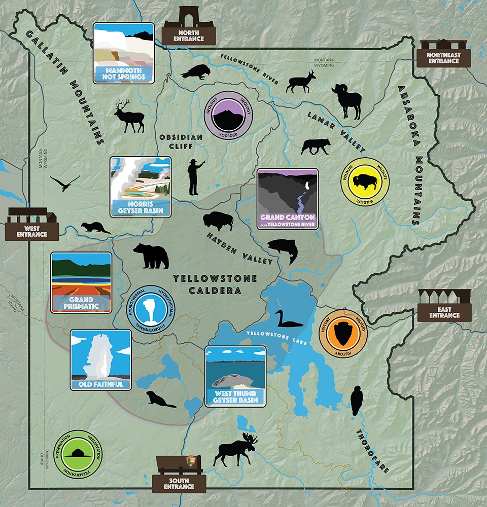
Wildlife Maps
Yellowstone is home to a diverse array of wildlife, including grizzly bears, wolves, elk, bison, and more. A wildlife map can help you identify the park’s many animal species and their habitats. These maps also provide important safety information about how to avoid encounters with wildlife and what to do if you do encounter them.
Yellowstone National Park is a vast and beautiful wilderness that offers endless opportunities for exploration and adventure. With so much to see and do, having a reliable map is essential. Whether you’re planning a day trip, a camping adventure, or a backcountry hike, the right map can help you make the most of your time in the park. From 3D maps to wildlife maps, there is a map for every type of visitor to Yellowstone. So, get your map, get out there, and start exploring this incredible national park!
Maps of Yellowstone
To learn more in-depth about 2D and 3D Yellowstone maps, view Yellowstone Maps.