3D Maps Glossary “K”
Maps Glossary WhiteClouds builds 3D Raised Relief Maps K A | B | C | D | E | F
Maps Glossary WhiteClouds builds 3D Raised Relief Maps K A | B | C | D | E | F
Maps Glossary WhiteClouds builds 3D Raised Relief Maps J A | B | C | D | E | F
Maps Glossary WhiteClouds builds 3D Raised Relief Maps I A | B | C | D | E | F
Maps Glossary WhiteClouds builds 3D Raised Relief Maps H A | B | C | D | E | F
Maps Glossary WhiteClouds builds 3D Raised Relief Maps G A | B | C | D | E | F
Maps Glossary WhiteClouds builds 3D Raised Relief Maps F A | B | C | D | E | F
Maps Glossary WhiteClouds builds 3D Raised Relief Maps E A | B | C | D | E | F
Maps Glossary WhiteClouds builds 3D Raised Relief Maps D A | B | C | D | E | F
Maps Glossary WhiteClouds builds 3D Raised Relief Maps B A | B | C | D | E | F
Maps Glossary WhiteClouds builds 3D Raised Relief Maps C A | B | C | D | E | F
The 3D map took me on a thrilling journey, from the mountaintops to the depths of the ocean. It was like having a bird’s-eye view of the world. Learn more about all the various types and categories of maps and explore the world in new dimensions.
Welcome to our glossary on maps! Whether you’re a cartographer, geographer, or simply someone who loves exploring the world, this resource is here to help you navigate the many terms and concepts that are essential to understanding maps. From projections to scales, and from legends to compasses, we’ve got you covered. Let’s start exploring!
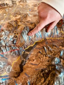
We meld top-of-the-line technologies with professional cartography resources to create stunning raised relief terrain maps and models. Our expertise in 3D printing enables us to allow more markets to benefit from purchasing durable, portable, and affordable models.

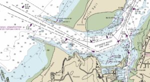
Experience the thrill of navigating the open seas with the help of nautical maps and charts. From Christopher Columbus’s exploration of the New World to modern-day sailors, learn more about nautical maps and their vital role in safe navigation and protecting life and property at sea.
Gazing upon the nautical map, the intricacies of the ocean were revealed to me. Every contour, depth, and current was charted with precision. It was like holding the world in my hands. Learn more about Nautical Maps and discover the wonders of the seas.
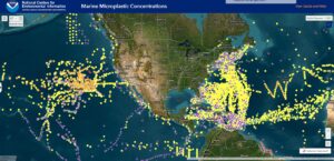
NOAA maps are revolutionizing the way we understand and predict weather and environmental conditions. From meteorologists to policymakers and everyday people, learn more about how these game-changing tools are being used to protect people and the planet.