USGS maps, produced by the United States Geological Survey, are some of the most detailed and iconic maps in the world. These maps have played a vital role in shaping our understanding of the American landscape, aiding everything from scientific research to outdoor exploration. With their meticulous topographical details and historical significance, these maps are invaluable tools for geographers, hikers, and historians alike. Below is a list of the top 10 USGS maps, ranked by size, each with its own fascinating story to tell.
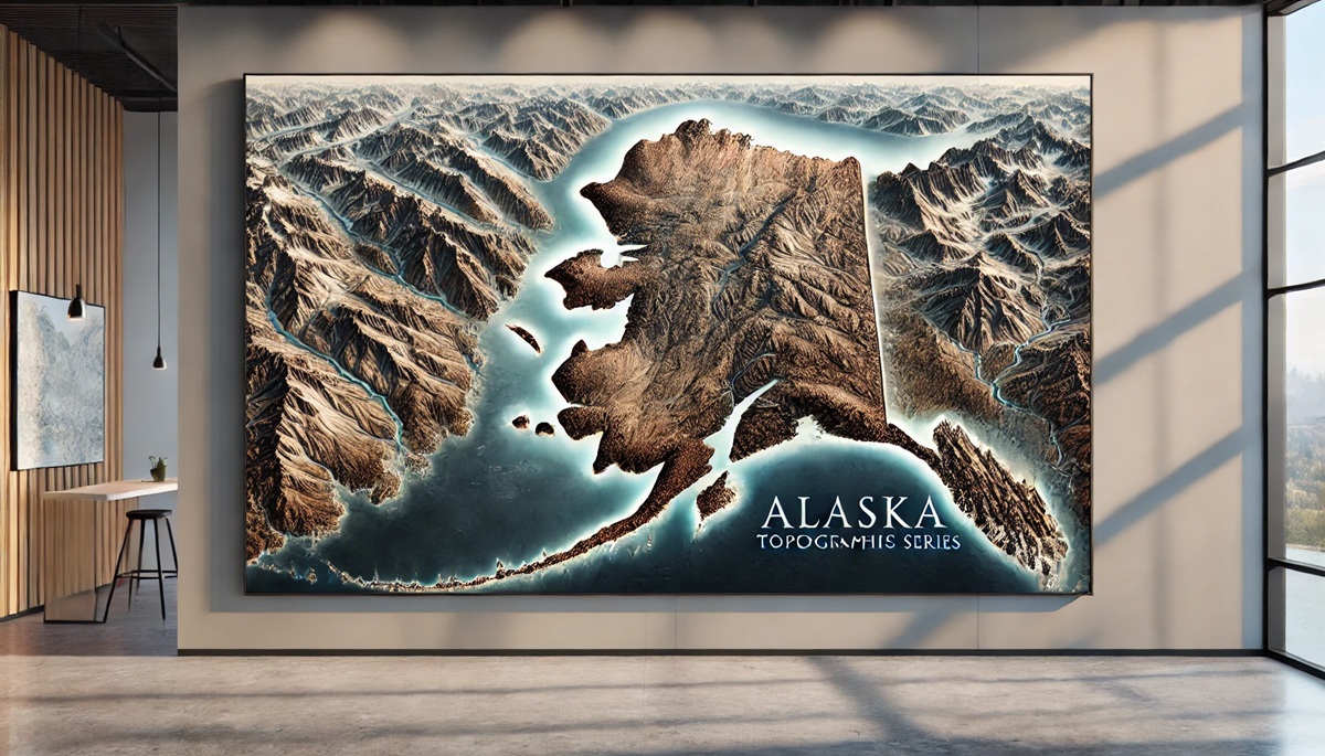
#1: Alaska Topographic Map Series, 63 Inches by 42 Inches (Each Sheet)
The Alaska Topographic Map Series is the largest and most ambitious USGS mapping project, spanning the vast and rugged terrain of America’s last frontier. Each sheet measures 63 inches by 42 inches and covers a portion of Alaska’s 663,000 square miles. First published in the mid-20th century, these maps were crucial for documenting Alaska’s topography, glaciers, and natural resources. The maps are known for their intricate details, including elevation contours and water bodies, making them indispensable for researchers and adventurers exploring the state. Stories of mountaineers using these maps to navigate Denali and oil companies employing them for resource exploration highlight their practical importance.
#2: Grand Canyon Topographic Map, 60 Inches by 36 Inches
The Grand Canyon Topographic Map is one of the most detailed and visually stunning USGS maps. At 60 inches by 36 inches, it provides a breathtaking view of the canyon’s complex geology and river systems. Created in the early 20th century, this map became a favorite among scientists studying erosion and adventurers planning rafting trips down the Colorado River. A notable anecdote involves a park ranger in the 1930s who used the map to rescue a group of stranded hikers, showcasing its life-saving utility.

#3: Yellowstone National Park Map, 54 Inches by 36 Inches
The Yellowstone National Park USGS map is a large and beautifully rendered depiction of America’s first national park. Measuring 54 inches by 36 inches, it highlights the park’s geothermal features, including geysers and hot springs, as well as its mountains and rivers. Originally created in the late 19th century, this map has been continually updated to reflect the park’s changing landscape. Interesting facts include its role in early park management and its use by famous naturalists like John Muir. Stories abound of visitors marveling at how accurately the map depicts the park’s unique terrain.
#4: Mount Rainier Quadrangle, 48 Inches by 32 Inches
The Mount Rainier Quadrangle is a detailed topographic map of Washington State’s iconic peak. Measuring 48 inches by 32 inches, it captures the mountain’s glaciers, ridges, and surrounding forests. First published in the early 1900s, the map has been a vital tool for climbers and geologists alike. A memorable story involves its use by early explorers charting new routes to the summit, underscoring its role in Mount Rainier’s mountaineering history.
#5: Sierra Nevada Topographic Map, 42 Inches by 30 Inches
This map of California’s Sierra Nevada range is a masterpiece of cartographic art and science. At 42 inches by 30 inches, it provides a detailed view of the range’s towering peaks and deep valleys. First published in the 20th century, the map has been a favorite of hikers and conservationists. One intriguing anecdote is its use by the Sierra Club to campaign for the protection of wilderness areas, highlighting its role in environmental history.
#6: Yosemite Valley Map, 36 Inches by 24 Inches
The Yosemite Valley USGS map is a smaller but no less detailed map of this iconic national park. Measuring 36 inches by 24 inches, it highlights the valley’s granite cliffs, waterfalls, and meadows. Created in the early 1900s, this map has been a key resource for tourists and scientists studying the park’s geology. Stories of climbers planning ascents of El Capitan and Half Dome with the help of this map emphasize its enduring significance.
#7: Appalachian Trail Map Series, 32 Inches by 20 Inches (Each Sheet)
The Appalachian Trail Map Series includes numerous sheets, each measuring 32 inches by 20 inches, that cover the 2,190-mile trail from Georgia to Maine. These maps, first produced in the mid-20th century, are essential for thru-hikers and trail maintainers. Anecdotes of hikers relying on these maps to navigate remote sections of the trail are plentiful, showcasing their practical importance.
#8: Death Valley Map, 30 Inches by 18 Inches
The Death Valley USGS map provides a detailed look at one of America’s most extreme landscapes. Measuring 30 inches by 18 inches, it highlights the valley’s dunes, salt flats, and surrounding mountains. Originally created in the 1920s, this map has been an essential resource for geologists and adventurers exploring this harsh environment. Stories of prospectors using the map during the California Gold Rush era add a historical dimension to its legacy.
#9: Glacier National Park Map, 24 Inches by 18 Inches
The Glacier National Park map is a compact yet detailed depiction of this stunning park in Montana. At 24 inches by 18 inches, it showcases the park’s glaciers, peaks, and lakes. First published in the mid-1900s, this map has been used by generations of visitors to plan their adventures. Anecdotes include conservation efforts inspired by the map’s vivid portrayal of retreating glaciers, highlighting its environmental significance.
#10: Hawaii Volcanoes National Park Map, 18 Inches by 12 Inches
The smallest map on the list, the Hawaii Volcanoes National Park map, measures 18 inches by 12 inches but is rich in detail. It highlights the park’s volcanic features, including Kilauea and Mauna Loa, as well as lava flows and craters. First published in the 1960s, the map has been a key resource for scientists studying volcanic activity. Stories of visitors using the map to safely navigate the park’s trails reflect its practical value.
USGS maps are far more than static representations of the landscape; they are living documents that have shaped history, guided explorers, and inspired countless people to connect with the natural world. Each map tells a story of discovery, resilience, and ingenuity, capturing the beauty and complexity of the American terrain. From the towering peaks of Alaska to the volcanic plains of Hawaii, these maps are a witness to the enduring importance of cartography in understanding and appreciating our world. As both tools and works of art, they continue to inspire exploration, education, and conservation efforts, cementing their place as invaluable treasures in the history of geography.