Pollution of lakes is a growing concern worldwide as these water bodies are not only essential ecosystems but also critical sources of drinking water, food, and recreation for humans. Despite their importance, many lakes suffer from contamination due to industrial waste, agricultural runoff, and urbanization. The following is a list of the top ten most polluted lakes in the world, organized by size. This list aims to provide an overview of their environmental issues, histories, and unique aspects to highlight the urgent need for conservation efforts.
#1: Lake Karachay – 2.2 square miles
Lake Karachay, located in Russia, is often regarded as one of the most polluted bodies of water on the planet. Measuring approximately 2.2 square miles, this small lake is notorious for its high levels of radioactive contamination. During the Soviet era, it became a dumping ground for nuclear waste from the nearby Mayak Production Association, a major nuclear facility. By the mid-20th century, the lake was so contaminated that standing near it for an hour could result in lethal radiation exposure.
Despite its grim history, Lake Karachay serves as a stark reminder of the dangers of unchecked industrial waste disposal. In the 1990s, efforts were made to fill the lake with concrete to prevent further contamination of the surrounding areas. Interestingly, this lake is now a case study in environmental recovery and the challenges of nuclear cleanup. Anecdotal stories of scientists and workers braving the hazardous environment to monitor radiation levels illustrate the human cost of such ecological disasters. While inaccessible to the public, Lake Karachay’s history continues to warn against the misuse of natural resources.

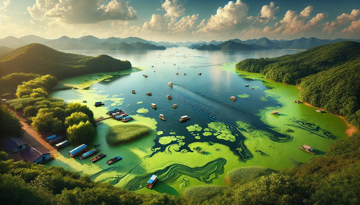
#2: Lake Taihu – 870 square miles
Lake Taihu in China spans a vast 870 square miles, making it the third-largest freshwater lake in the country. Unfortunately, its beauty has been marred by severe pollution, primarily from industrial runoff, untreated sewage, and agricultural activities. The lake frequently suffers from massive algal blooms, turning its once-clear waters into a green, foul-smelling expanse. These blooms are caused by nutrient overloads, particularly phosphorus and nitrogen, which disrupt the lake’s ecosystem.
Historically, Lake Taihu has been a vital resource for fishing and agriculture, supporting millions of people in the Jiangsu, Zhejiang, and Anhui provinces. Today, it’s a symbol of the conflict between economic development and environmental protection in China. Efforts to clean the lake, such as the reduction of pollutants and the construction of wastewater treatment plants, have shown some promise. Locals share tales of once-thriving fisheries and pristine waters, serving as poignant reminders of what has been lost. Despite its challenges, Lake Taihu remains a focal point for conservation advocacy and scientific research.
#3: Lake Victoria – 26,828 square miles
Lake Victoria, the largest lake in Africa, covers an expansive 26,828 square miles, touching the borders of Tanzania, Uganda, and Kenya. While it is a crucial resource for millions of people, the lake faces significant pollution challenges. Industrial discharges, agricultural runoff, and untreated sewage have led to deteriorating water quality. Additionally, invasive species like the water hyacinth and the Nile perch have disrupted the lake’s ecosystem.
Historically, Lake Victoria has been central to the livelihoods of the surrounding communities, providing fish, freshwater, and transportation routes. Anecdotes from local fishermen tell of dwindling fish stocks and the struggles of navigating waters choked with invasive plants. In recent years, various environmental initiatives have sought to restore the lake’s health, including reforestation projects and waste management programs. Despite its pollution issues, Lake Victoria remains a lifeline for East Africa, underscoring the urgency of sustainable management.
#4: Lake Erie – 9,910 square miles
Lake Erie, one of North America’s Great Lakes, spans approximately 9,910 square miles. It has suffered from pollution due to agricultural runoff, industrial waste, and urbanization. The lake is infamous for its algal blooms, fueled by excessive phosphorus levels from fertilizers. In the 1960s and 1970s, Lake Erie was declared “dead” due to severe eutrophication, prompting international cleanup efforts by the United States and Canada.
Stories of the lake’s revival through cooperative efforts are inspiring, though challenges persist. Despite improved conditions, periodic algal blooms continue to threaten the ecosystem and local economies. Lake Erie remains a witness to the potential for recovery when nations prioritize environmental health. Its history also serves as a cautionary tale about the consequences of industrial and agricultural neglect.
#5: Lake Maracaibo – 5,100 square miles
Located in Venezuela, Lake Maracaibo spans about 5,100 square miles, making it one of South America’s largest lakes. Despite its size and historical importance, the lake is heavily polluted due to oil spills, industrial discharges, and untreated sewage. The oil-rich region has long been a hub of petroleum extraction, but the resulting pollution has devastated local ecosystems.
Lake Maracaibo’s history is intertwined with the development of Venezuela’s oil industry, which brought economic prosperity but also environmental degradation. Anecdotal accounts from local residents describe the lake’s transformation from a vibrant, life-sustaining resource to a polluted body of water. Efforts to clean up the lake have been hampered by economic and political instability, making its future uncertain. The plight of Lake Maracaibo highlights the delicate balance between natural resource exploitation and environmental conservation.
#6: Lake Okeechobee – 730 square miles
Lake Okeechobee in Florida covers approximately 730 square miles, serving as a critical water reservoir for the state. However, the lake faces significant pollution challenges due to agricultural runoff, stormwater discharge, and algal blooms. These issues have not only degraded the lake’s water quality but also threatened the ecosystems of the Everglades, which rely on its outflows.
The history of Lake Okeechobee is deeply tied to Florida’s development, with stories of settlers relying on its waters for irrigation and transport. Anecdotal tales of fishing trips and pristine landscapes contrast sharply with the current state of the lake. Cleanup efforts, including stricter regulations on agricultural practices and investment in water treatment infrastructure, aim to restore the lake’s health. Lake Okeechobee’s struggles underscore the importance of proactive environmental management.
#7: Onondaga Lake – 4.6 square miles
Onondaga Lake, located in New York State, measures about 4.6 square miles and has long been considered one of the most polluted lakes in the United States. Once a popular destination for recreation and fishing, the lake became a dumping ground for industrial waste and untreated sewage during the 20th century. Mercury contamination from nearby factories severely impacted the lake’s ecosystem and posed health risks to humans.
Efforts to clean up Onondaga Lake began in earnest in the 1980s, leading to significant improvements in water quality. However, the lake’s legacy of pollution remains a stark example of industrial negligence. Anecdotes from local communities recall a time when the lake was a source of pride and joy, contrasting with the decades of environmental degradation. Today, Onondaga Lake is undergoing a gradual recovery, serving as a model for similar restoration efforts worldwide.
#8: Bellandur Lake – 3.6 square miles
Bellandur Lake in Bangalore, India, covers approximately 3.6 square miles and is infamous for its extreme levels of pollution. This urban lake has become a receptacle for untreated sewage, industrial effluents, and construction debris. The lake is often seen foaming with toxic chemicals, and occasional fires caused by flammable pollutants have further highlighted its dire state.
Historically, Bellandur Lake was a critical water source for Bangalore’s residents and a hub for fishing and agriculture. Anecdotal stories of local fishermen recall thriving aquatic life that has long since disappeared. Despite its current condition, efforts are underway to restore the lake through government initiatives and citizen activism. Bellandur Lake’s plight underscores the environmental challenges faced by rapidly urbanizing cities.
#9: Dal Lake – 6.9 square miles
Dal Lake, situated in Srinagar, India, spans approximately 6.9 square miles and is known for its picturesque beauty. However, pollution from untreated sewage, agricultural runoff, and encroachment has severely affected the lake’s ecosystem. Algal blooms and sedimentation have reduced water quality, impacting the livelihoods of those who rely on the lake for tourism and fishing.
Dal Lake’s history is deeply tied to Kashmir’s cultural and economic heritage. Stories of houseboats and shikara rides paint a romantic picture of the lake’s past, contrasting sharply with its current state. Recent initiatives to clean up Dal Lake focus on reducing pollution and restoring its ecological balance. Despite its challenges, the lake remains an iconic symbol of Kashmir’s natural beauty.
#10: Lake Champlain – 490 square miles
Lake Champlain, straddling the borders of Vermont, New York, and Quebec, covers approximately 490 square miles. While it is a vital freshwater resource, the lake faces pollution from agricultural runoff, stormwater discharge, and invasive species. Algal blooms, caused by excess phosphorus, have become an increasing problem, threatening the lake’s water quality and aquatic life.
Historically, Lake Champlain has been a crucial waterway for trade and transportation. Anecdotes from local residents highlight its role in shaping the region’s culture and economy. Cleanup efforts, including stricter agricultural regulations and community-driven conservation projects, aim to preserve the lake’s health for future generations. Lake Champlain’s story reflects the broader struggle to balance human activity with environmental preservation.
The lakes highlighted in this list reflect the devastating impact of pollution on some of the world’s most vital ecosystems. While their histories and challenges vary, a common thread runs through them: the need for urgent and sustained conservation efforts. By learning from these examples, humanity can strive to protect and restore these natural treasures for future generations.