Where Desert Geometry Comes to Life
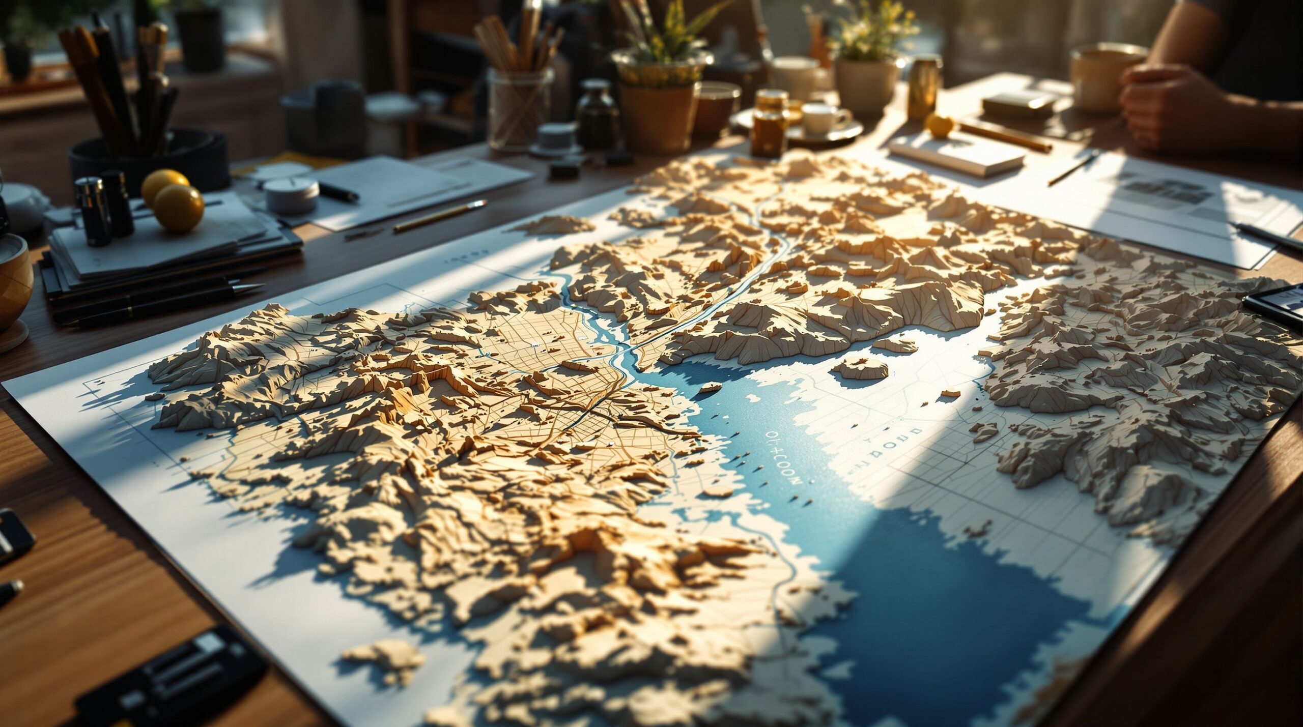
A 3D topographic map of Phoenix, Arizona is more than a visual representation of elevation. It is a story carved into terrain, revealing how a vast desert basin, rugged mountain ranges, and engineered waterways converge to support one of the fastest-growing metropolitan areas in the United States. Phoenix often appears flat at a glance, especially to visitors arriving by air, but a three-dimensional perspective transforms that assumption instantly. When elevation rises off the surface and shadows define ridgelines, the city’s true complexity comes into focus. From the volcanic silhouettes of the Phoenix Mountains to the broad Salt River Valley that cradles the city, a 3D topographic map brings clarity, depth, and movement to a landscape shaped by geology, climate, and human ingenuity.
The Geological Backbone of the Valley of the Sun
Phoenix sits within the Basin and Range Province, a geologic region defined by stretched crust, faulted mountains, and wide valleys filled with sediment. A 3D topographic map makes this structure unmistakable. The city lies in a broad lowland basin, with elevations rising sharply toward mountain ranges like South Mountain, the McDowell Mountains, and the White Tank Mountains. These ranges are not random features but the exposed spines of ancient tectonic processes that pulled the earth apart over millions of years. Seeing these formations in three dimensions highlights their steep escarpments, asymmetrical slopes, and the way they frame the urban core. The map becomes a geological cross-section, showing how Phoenix exists not on flat land, but within a carefully balanced bowl of stone and sediment.
Mountains That Shape the City’s Identity
Few cities are as visually defined by their mountains as Phoenix, and a 3D topographic map captures this relationship with striking clarity. South Mountain rises abruptly from the southern edge of the city, creating one of the largest urban parks in the country. Camelback Mountain, with its iconic profile, stands as a dramatic centerpiece near the city’s heart, while Piestewa Peak and the surrounding Phoenix Mountains form a rugged spine running through the metro area. In three dimensions, these landmarks are no longer just names or silhouettes. Their elevation gains, ridgelines, and erosion patterns become tangible. The map shows how neighborhoods bend around these features, how roads navigate passes and valleys, and how natural barriers have influenced growth patterns over time.
Water, Washes, and the Desert’s Hidden Veins
Water defines Phoenix as much by its absence as by its presence, and a 3D topographic map reveals the subtle pathways that water follows through the desert. The Salt River, now largely controlled and often dry at the surface, once shaped the valley through seasonal flooding and sediment deposition. In relief form, the river’s channel and floodplain are easier to trace, showing why early settlements formed where they did. Equally important are the washes, those ephemeral waterways that only flow during storms. In three dimensions, their shallow channels and branching patterns become visible across the valley floor. These features explain modern flood control infrastructure, greenbelt placement, and the careful engineering required to live sustainably in a desert environment.
Urban Growth Seen Through Elevation
Phoenix’s rapid expansion takes on new meaning when viewed through a 3D topographic lens. The map reveals how development spreads outward along flatter terrain while respecting steeper slopes and protected mountain preserves. Elevation changes influence road design, drainage systems, and even microclimates within the city. Higher elevations often experience slightly cooler temperatures and different vegetation, factors that subtly affect land use and housing patterns. A three-dimensional map allows viewers to see how suburban growth radiates across the valley floor, how transportation corridors align with natural gradients, and how urban density shifts in response to the terrain. It becomes clear that Phoenix’s layout is not arbitrary, but a direct response to the land beneath it.
Why 3D Topographic Maps Change Understanding
Flat maps provide information, but 3D topographic maps provide intuition. Elevation, slope, and spatial relationships are easier to grasp when the landscape has depth. For Phoenix, this means understanding why certain areas are prone to flooding, why some neighborhoods offer sweeping views while others sit sheltered in lowlands, and why mountain preserves play such a critical role in urban planning. A 3D map bridges the gap between data and experience, allowing viewers to perceive the city as a living system rather than a collection of streets and parcels. For educators, planners, designers, and residents alike, this perspective fosters a deeper appreciation of how Phoenix functions as both a city and an ecosystem.
How a 3D Topographic Map of Long Beach Might Be Fabricated
A physical 3D topographic map can be built in many ways, but professional fabricators typically follow a multi-stage process involving digital modeling, material carving, structural engineering, and hand-finishing.
Step 1: Gather Accurate Elevation Data
The process begins with acquiring detailed elevation information, often pulled from USGS LiDAR scans or official government terrain datasets. This raw data is cleaned, scaled, and converted into a high-resolution digital terrain model that serves as the blueprint for every hill, valley, slope, and shoreline.
Step 2: Create and Slice the Digital 3D Model
Fabricators use the digital terrain file to generate a 3D model, which is then sliced into layers or relief sections. These slices are prepared for CNC routing, 3D printing, or laser cutting. Materials such as foam, wood, acrylic, and composite panels are chosen based on the size, weight, and finish of the final piece. For large models, a stacked-layer technique may be used, with each laser-cut sheet representing an elevation level that builds upward like a topographic puzzle.
Step 3: Assemble the Base Terrain
Once the layers are cut, they are assembled into the full terrain structure. Each piece is carefully aligned and bonded to form the complete landform. As the layers come together, the natural contours of the region—ridges, slopes, channels, and coastal edges—begin to take shape in three dimensions.
Step 4: Refine and Sculpt the Surface
Fabricators refine the terrain through sanding, smoothing, shaping, and reinforcing key areas. This stage ensures that the surface flows naturally and avoids visible step lines from the layering process. Additional geographic or architectural elements—such as islands, breakwaters, bluffs, or built structures—may be added as raised components to enhance realism.
Step 5: Apply Artistic Finishing and Color
Finishing transforms the raw structure into a lifelike map. Artists use soft gradients to convey elevation changes, natural coastal hues to blend blues into sandy shoreline tones, and subtle shadows to enhance depth and contrast. The Long Beach coastline especially benefits from delicate tonal transitions that highlight its gentle curves and engineered waterfront features.
Step 6: Add Labels, Protection, and Presentation Features
Depending on the purpose of the map, labels, borders, frames, or protective coatings can be added. Some high-end models remain unlabeled, allowing the terrain itself to serve as a sculptural art piece. The final result is a vivid, professionally crafted 3D topographic display that balances scientific accuracy with artistic expression.
From Digital Terrain to Physical Form
Fabricating a 3D topographic map of Phoenix begins with high-resolution elevation data, often sourced from LiDAR surveys or satellite-derived digital elevation models. This data is processed to exaggerate or refine elevation changes depending on the desired visual impact. Once the digital model is finalized, it can be translated into a physical form using techniques such as CNC milling, 3D printing, or layered laser-cut materials. Each method offers a different balance of precision, texture, and scale. Materials might include wood, resin, metal, or composite plastics, with finishes applied to highlight elevation, water features, or urban areas. The fabrication process transforms raw data into a tactile object, allowing viewers to physically engage with the landscape of Phoenix in a way that screens cannot replicate.
A City Best Understood in Three Dimensions
A 3D topographic map of Phoenix, AZ is ultimately a tool for connection. It connects past geology to present development, natural systems to human infrastructure, and abstract data to visual storytelling. In three dimensions, the Valley of the Sun reveals itself as a carefully balanced environment where mountains, water, and urban life coexist in a delicate arrangement. Whether used as an educational resource, a planning aid, or a piece of functional art, a 3D topographic map invites viewers to see Phoenix not just as a city on the desert floor, but as a dynamic landscape shaped by time, movement, and resilience.