A Sculpted Look at Colorado’s Iconic Mountain City
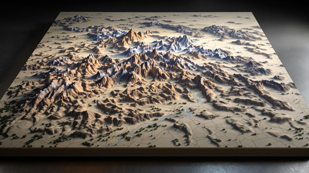
Boulder, Colorado, is a city shaped—quite literally—by the dramatic geography that surrounds it. Nestled at the foot of the Front Range and framed by the unmistakable Flatirons, Boulder balances the energy of an outdoor paradise with the charm of a vibrant university town. Nearly everywhere you stand, the land tells a story, and every trail, ridge, canyon, or foothill adds texture to the city’s identity. Now imagine capturing all of that natural drama, complexity, and beauty in a single sculptural form: a 3D topographic map of Boulder. A 3D topographic map transforms Boulder’s iconic landscape into a tactile, visually compelling model. It highlights the steep ascents of the Flatirons, the rolling foothills leading toward the plains, the winding canyons, the elevation breaks, and the city’s neatly organized neighborhoods that sit at the meeting point of rugged mountain and open prairie. A 3D topo map becomes more than a representation—it becomes a carved landscape of movement, meaning, and memory. In this immersive guide, we’ll explore what makes Boulder a standout subject for three-dimensional mapping, how its unique terrain becomes sculptural form, what the city reveals when viewed from a topographic perspective, and how a physical 3D model of Boulder can be fabricated from raw data into a stunning display piece. Whether you’re a cartography enthusiast, a designer, a geologist, a hobbyist fabricator, or someone who simply loves Boulder’s outdoor spirit, a 3D topographic map brings the city’s natural drama to life in a way that few visual tools can match.
Why 3D Topographic Maps Are Captivating
Topographic maps show the shape of the land. But when that data is pulled upward into physical relief, the terrain becomes instantly understandable. You don’t interpret it—you feel it. A 3D topographic map captures elevations, ridgelines, valleys, and slopes with the intuitive clarity of sculpture. Your eyes follow the mountain faces, your hands trace the ridges, and your imagination travels the routes carved by nature over millions of years.
The human brain connects deeply with dimensionality. We process shape more quickly than symbols or contour lines. That’s why 3D topo maps have an artistic presence as well as a scientific purpose. They’re engaging, informative, and visually powerful. And when the subject is a place as dramatic as Boulder, the impact becomes almost cinematic.
Boulder’s terrain is not subtle. Its elevation jumps sharply from plains to mountains, presenting dramatic geological formations that seem engineered for three-dimensional storytelling. In a 3D model, these features take center stage in a miniature world that captures the soul of the city.
Boulder, CO: A Landscape Built for Three Dimensions
Few cities in the United States transition so abruptly from flatlands to steep mountainous terrain. Boulder practically leans against the foothills, creating a dramatic topographic divide visible from nearly any point in the city. This contrast makes Boulder an especially fascinating subject for 3D modeling.
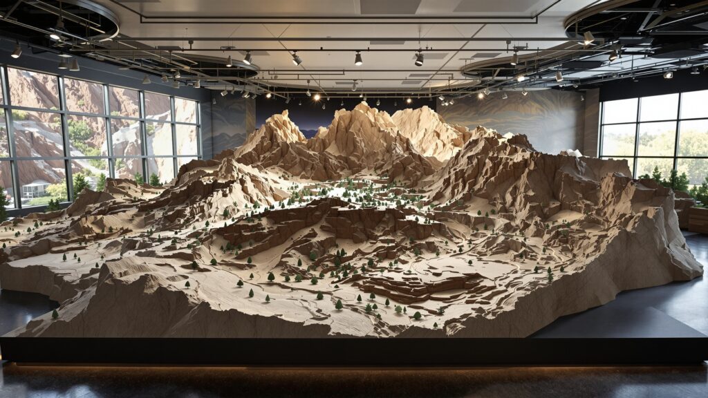
- The most iconic feature—the Flatirons—becomes a sculptural marvel when recreated in relief. Their slanted faces, ridged surfaces, and staggered arrangement form a jagged wall rising above the city. In three dimensions, they stand like geological monoliths emerging from the earth.
- Boulder’s foothills add continuous waves of elevation, each hill rolling into the next in a pattern that feels both rhythmic and ancient. A 3D map showcases these undulations with texture and depth.
- The canyons—Boulder Canyon, Sunshine Canyon, and Fourmile Canyon—cut deep paths into the terrain. Their winding shapes, steep walls, and shadowed valleys gain clarity when elevated into physical form.
- South Boulder’s Mesa Trail corridor, with its gradual elevation gain and panoramic ridgelines, becomes a layered tapestry of incline and connection. Meanwhile, the northern plains open outward, giving the map a visual contrast that emphasizes how dramatically the landscape changes as you move from city center to countryside.
In a 3D topographic map, Boulder becomes a dynamic, sculptural interplay of sharp ascents, wide valleys, rolling foothills, and high-altitude drama.
Understanding Boulder’s Terrain Through 3D Relief Mapping
A 3D topo map doesn’t just represent Boulder—it reveals it. Features that might feel disconnected on a flat map come together in a cohesive, tangible whole when shown in relief.
The Flatirons become the dominant geological characters, rising sharply at angles that seem too steep to be real unless seen in three dimensions. Model makers can capture the layers of sandstone, the diagonal tilt, and the knife-edge ridges that define their structure. Further west, the foothills behind Boulder form a series of rounded, weathered rises. These hills appear almost soft, shaped by erosion and time. In three dimensions, you can visually trace the geological forces that sculpted them.
The canyons pull your eyes deeper into the mountains, carving channels that snake inward with complex patterns. A 3D map captures the sudden drop-offs, the narrowing chasms, and the way the city centers itself around these natural corridors. Eastward, the landscape softens into the vast Colorado plains. The elevation gently declines, creating a contrast to the mountain edge. In a 3D model, this transition feels like a natural exhale—Boulder’s rugged intensity easing into open sky.
Neighborhoods and landmarks take on new meaning when viewed through topography. The University of Colorado Boulder lies at the base of the foothills, its campus gently sloping upward. Chautauqua Park rests at the foot of the Flatirons, almost appearing to lean toward them in a 3D representation. North Boulder’s blend of creative spaces and residential districts sits atop small rises, while the Pearl Street area rests in a smooth—a bit lower—central basin. This bird’s-eye sculptural viewpoint turns familiar spaces into an interconnected geographic story.
The Intersection of Human Life and Boulder’s Terrain
Boulder’s relationship with its landscape is as strong as its outdoor culture. A 3D topographic map highlights the interplay between natural formations and human activity.
The city’s street layout reveals how planners worked around the terrain. Roads curve to follow the foothills or cut straight through flatter zones. Trails meander along ridges, escarpments, and canyon sides, tracing paths that reflect natural flow rather than strict geometry.
Boulder Creek becomes a defining line across the model, running from Boulder Canyon through the heart of the city before heading eastward. In relief form, the creek’s path becomes clear, illustrating why so much of Boulder’s life, culture, and recreation orients around it.
Chautauqua’s historic cottages appear nestled in a cradle formed by sloping land at the base of the Flatirons. The university campus stretches along a gentle incline. The bike paths, sports fields, and open spaces take shape within the topographic rhythm of hills and valleys.
The result is a visual narrative of how Boulder has grown in response to its geological environment. The land is not an afterthought—it is the foundation upon which the city’s culture thrives.
What a 3D Topographic Map of Boulder Can Be Used For
One of the greatest strengths of a 3D topo map is its versatility. It’s both visually impressive and deeply informative, making it useful in many contexts.
- Educators use 3D maps to teach geology, geography, and environmental science. Students instantly grasp the relationship between Boulder’s mountains and plains when they can see and touch the elevation changes.
- Interior designers use topographic sculptural pieces as striking wall art or tabletop centerpieces in homes, offices, lobbies, and commercial spaces. Boulder’s terrain makes for an especially dramatic display.
- Outdoor retailers, visitor centers, and tourism departments often use 3D models as interactive exhibits. Nothing ignites curiosity like a miniature mountain range rising from a display case.
- Researchers benefit from the clarity 3D relief maps provide when analyzing watershed patterns, erosion behavior, trail networks, or geological changes.
- Hikers, climbers, and outdoor enthusiasts use 3D models for understanding routes, ascents, and ridge structures before heading out into the field.
And for Boulder locals and fans, a 3D topographic map becomes a piece of artistic homage—an elegant tribute to the city’s awe-inspiring landscape.
How a 3D Topographic Map of Boulder, CO Might Be Fabricated
Fabricating a 3D topographic model involves a blend of digital precision, material craftsmanship, structural assembly, and artistic finishing.
Step 1: Gather Accurate Elevation Data
The process begins by collecting precise elevation information from sources such as USGS LiDAR scans or high-resolution terrain datasets. This raw data is cleaned, scaled, and converted into a detailed digital 3D model, capturing every slope, ridge, canyon, and escarpment in Boulder’s terrain. The resulting file becomes the blueprint for the entire fabrication process.
Step 2: Slice the Digital Model for Production
Fabricators divide the 3D terrain model into relief sections suitable for cutting on CNC routers, 3D printers, or laser cutters. Materials vary depending on project needs—foam, wood, acrylic, and composite sheets are common choices. Large display models often use a layer-stacking method, where each sheet represents a specific elevation slice that builds upward like a geological puzzle.
Step 3: Assemble the Terrain Layers
Once all pieces have been cut, they are carefully assembled and bonded together. As the layers rise, the topography takes shape, revealing the foothills, canyons, and the dramatic incline of the Flatirons. Edges and transitions are refined through sanding and shaping to eliminate visible steps and to create natural land contours. Additional details such as sharp canyon edges, rock faces, or man-made structures may be added to elevate accuracy and realism.
Step 4: Refine and Finish the Surface with Artistic Detail
Artists then transform the raw structure into a lifelike terrain model. Paint gradients mimic natural elevation coloration—from deep earthy tones in the mountains to softer greens across the plains. Highlights and shadows are applied to enhance depth and dimension. The Flatirons receive especially careful attention, with warm sandstone hues that capture their iconic character.
Step 5: Add Presentation Features and Protective Elements
Optional additions—including borders, frames, labels, or protective coatings—are incorporated depending on the intended display style. Many high-end models are intentionally left unlabeled to let the sculptural quality of the terrain stand on its own. The final piece is a polished, artistic, and scientifically accurate 3D topographic representation of Boulder’s powerful and dramatic landscape.
Why Boulder Comes Alive in Three Dimensions
Boulder is already one of the most visually compelling cities in the country, but a 3D topographic map elevates its character to a new level. It reveals the drama of the mountains, the rise of the foothills, and the calm sweep of the plains in one continuous form. It allows viewers to understand how the city connects to its natural surroundings. When rendered in 3D, Boulder’s terrain feels alive. The Flatirons jut upward like the pages of a geological storybook. The canyons pull your eyes toward deeper wilderness. The slopes and valleys shape the city’s neighborhoods with clear logic and purpose. It becomes instantly obvious why Boulder lives, plays, and thrives the way it does—because the land itself shapes its identity. A 3D topographic map becomes not only a tool for understanding Boulder but also a celebration of it.