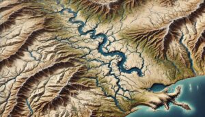
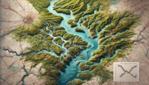
Month: June 2024

Kentucky Watershed Maps

Explore Kentucky’s vital watersheds, from the Ohio River to the Cumberland River, and discover how 3D mapping technology is transforming water management. Learn how these advanced maps provide key insights into water flow, conservation, and climate change adaptation, ensuring sustainable solutions for agriculture, industry, and ecosystem protection across the Bluegrass State.

Read More »
Nevada Watershed Maps

Nevada Watershed Maps

Discover Nevada’s complex watersheds through detailed maps that reveal the movement of water, ecosystems, and resource management. Learn how 3D mapping technology helps preserve water systems, support agriculture, and guide future sustainability efforts in the Silver State.

Read More »

Licking River Watershed Map

Discover the Licking River Watershed, a vital Kentucky system rich in biodiversity and history. Explore its intricate hydrology, seasonal dynamics, and how innovative 3D mapping transforms understanding, aiding in sustainable management and conservation of this essential waterway for future generations.

Read More »
Hawaiian and Island Watershed Maps

Hawaiian and Island Watershed Maps

Explore the Hawaiian and Island Watersheds, where volcanic mountains and tropical ecosystems rely on intricate water systems. Discover how 3D mapping technology is revolutionizing our understanding of these unique regions, helping preserve their delicate balance and ensuring sustainable water use for future generations.

Read More »
Hawaii Watershed Maps

Hawaii Watershed Maps

Discover Hawaii’s unique watersheds, where mountains, rivers, and ecosystems converge. Explore how 3D mapping technology is transforming water management, offering key insights into water flow, conservation, and climate change adaptation. Learn how these advanced maps ensure sustainable solutions for agriculture, urban growth, and ecosystem protection across the Hawaiian Islands.

Read More »
New Jersey Watershed Maps

New Jersey Watershed Maps

Discover New Jersey’s intricate water systems through detailed watershed maps. Explore how 3D mapping technology helps manage water resources, protect ecosystems, and ensure sustainable development. Gain insights into the flow of water, key habitats, and the future of the Garden State’s watersheds.

Read More »
Missouri Watershed Maps

Missouri Watershed Maps

Discover Missouri’s vital watersheds, from the Missouri and Mississippi Rivers to countless streams, and explore how 3D mapping technology is revolutionizing water management. These maps provide critical insights for flood control, water quality, and ecosystem conservation, ensuring sustainable water solutions for agriculture, industry, and wildlife across the state.

Read More »
Red River Watershed (North) Map

Red River Watershed (North) Map

Dive into the Red River Watershed, a vast system shaping the Great Plains. Discover its hydrology, biodiversity, and how 3D mapping innovations like Green River models transform watershed insights and strategies for sustainable future planning.

Read More »

Get a Free Quote on a Custom 3D Billboard

Get a Free Quote