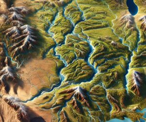
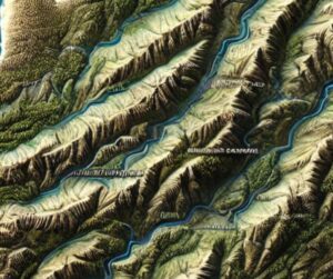
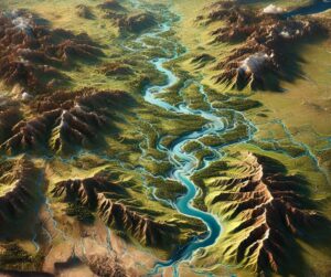
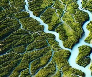
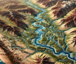
Month: June 2024

St. Johns River Watershed Map

St. Johns River Watershed Map

Discover the St. Johns River Watershed, Florida’s ecological treasure. Explore its intricate river networks, vibrant wetlands, and rich biodiversity through the St. Johns River Watershed Map. Learn how 3D mapping innovations transform understanding, driving sustainable management and conservation of this vital waterway. From its marshy headwaters to coastal estuaries, this watershed connects nature, communities, and a resilient future.

Read More »
Brazos River Watershed Map

Brazos River Watershed Map

Discover the Brazos River Watershed, Texas’s largest river system, vital for ecosystems and communities. Explore its intricate networks through the Brazos River Watershed Map, and learn how 3D mapping innovations transform understanding, fostering sustainable management and conservation. From arid plains to coastal estuaries, this watershed connects nature and people, shaping a resilient future for Texas.

Read More »
Portugal Watershed Maps

Portugal Watershed Maps

Portugal’s watersheds, including the Douro, Tejo, and Guadiana River Basins, are crucial for agriculture, ecosystems, and water management. Learn how modern technologies like 3D mapping, GIS, and remote sensing help monitor and manage these systems, ensuring sustainable water use and addressing challenges like climate change, water scarcity, and growing population demands.

Read More »
Humboldt River Watershed Map

Humboldt River Watershed Map

Dive into the Humboldt River Watershed, a vital water source in Nevada. Learn how 3D mapping technology enhances water management, conservation, and flood prediction. Explore its ecological importance and the challenges it faces from climate change and development.

Read More »
Australia Watershed Maps

Australia Watershed Maps

Explore Australia’s watersheds, including the Murray-Darling and Fitzroy river basins, which are vital for agriculture, hydropower, and biodiversity. Learn how 3D mapping technologies are transforming water resource management by providing insights into water flow, land use, and environmental health. These tools help ensure sustainable practices, manage water scarcity, and protect ecosystems, ensuring the long-term availability of water resources across the country.

Read More »
Sabine River Watershed Map

Sabine River Watershed Map

Discover the Sabine River Watershed, a critical lifeline for ecosystems and communities in Texas and Louisiana. Explore its intricate hydrology, vibrant biodiversity, and how 3D mapping innovations transform understanding, aiding in sustainable management and conservation of this vital resource. From wetlands to urban landscapes, the Sabine River Watershed Map connects people and nature for a resilient future.

Read More »
Suwannee River Watershed Map

Suwannee River Watershed Map

Dive into the Suwannee River Watershed, a vital Southeastern ecosystem defined by springs, rivers, and diverse habitats. Discover its intricate hydrology and how 3D mapping innovations, like those for the Green River Watershed, bring its complexity to life. Explore the balance of nature and human impact, and uncover strategies to preserve this iconic system for future generations.

Read More »
El Salvador Watershed Maps

El Salvador Watershed Maps

El Salvador’s watershed maps are essential for managing river systems, predicting floods, and ensuring sustainable water use. These maps guide water allocation for agriculture, industry, and communities while addressing climate change challenges and preserving biodiversity in the country’s diverse ecosystems.

Read More »
Yakutat River Watershed Map

Yakutat River Watershed Map

Discover the Yakuta River Watershed, a lifeline of biodiversity and resources. Explore its intricate river networks and vibrant ecosystems through the Yakuta River Watershed Map. Learn how 3D mapping innovations revolutionize understanding, fostering sustainable management and conservation. From rugged highlands to fertile plains, this watershed connects communities and nature, shaping a resilient future for generations to come.

Read More »
Minnesota River Watershed Map

Minnesota River Watershed Map

Dive into the Minnesota River Watershed, a vital Midwest ecosystem connecting communities and nature. Explore its intricate river networks and diverse habitats through the Minnesota River Watershed Map. Learn how 3D mapping innovations transform understanding, fostering sustainable management and conservation of this critical waterway for future generations. From agricultural lands to wetlands, this watershed plays a central role in the region’s environmental and economic health.

Read More »

Get a Free Quote on a Custom 3D Billboard

Get a Free Quote