Snowbasin 3D Maps

Snowbasin 3D Maps

We Build Custom 3D Snowbasin Maps

Did you know we make

large 3D Maps?

Monterey 3D-printed topography map model with custom pedestal base

Unveiling the Secrets of Snowbasin Ski Resort’s 3D Maps

Nestled in the picturesque Wasatch Range, Snowbasin Ski Resort is a winter paradise like no other.  Just a short drive from Salt Lake City, this gem boasts over 3,000 acres of skiable terrain that caters to all skill levels. With dense pine forests, towering peaks, and expansive open bowls blanketed in pristine snow, the resort’s breathtaking landscapes are a sight to behold. 

These diverse terrains, combined with the assistance of 3D maps, offer skiers and snowboarders an invaluable tool for traversing Snowbasin with confidence.  Whether you’re seeking gentle slopes through the pine-laden forests or navigating the challenging steeps of towering peaks, these 3D maps ensure you stay on course, enhancing your overall experience in this winter wonderland.  Moreover, you can also appreciate the beauty of Snowbasin from the comfort of your home by studying the 3D map on your coffee table, or within the lobby at Snowbasin itself, providing a sneak peek into the adventure that awaits. Additionally, 3D maps have applications beyond skiing, such as aiding hikers in exploring rugged trails or helping tourists navigate unfamiliar cityscapes.  Their versatility and precision make them indispensable tools for adventurers and explorers across various landscapes and activities.

Park City Topographic Map 1 Park City 3D Raised Relief Map 

Features of 3D Maps for the Snow Basin Ski Resort

3D raised relief maps prove to be indispensable tools when it comes to comprehending and navigating the captivating alpine landscapes of Snowbasin Ski Resort in three dimensions.  These innovative maps offer a tactile and lifelike representation of the resort’s terrain, enhancing the way visitors interact with and appreciate the mountainous surroundings.  Let’s explore the unique features of 3D maps tailored to the Snowbasin experience:

Physical Representation

Crafted from materials such as plastic, resin, or foam, 3D raised relief maps physically manifest Snowbasin’s geographical features, including its majestic peaks, thrilling slopes, and pristine valleys.  These models faithfully mirror the shape and elevation of the resort’s terrain, providing a hands-on experience of the mountain.

Topographic Detail

Snowbasin’s 3D maps meticulously capture the intricate topographic details of the resort, showcasing elevation changes, slope gradients, and contour lines.  Skiers and snowboarders can visually assess the steepness of the runs, the depth of valleys, and the flow of trails, gaining a profound understanding of the resort’s topography.

Scale and Size

Available in various scales and sizes, Snowbasin’s 3D maps cater to diverse preferences and needs.  From compact tabletop models ideal for educational purposes to grand wall-mounted displays suitable for decorative or planning purposes, visitors can choose the scale that best suits their intended use.

Color and Texture

Color-coded representations on these maps distinguish different types of terrain and land cover, such as vibrant green for forests, serene blue for water bodies, and earthy brown for rugged mountains.  Some maps also incorporate texturing to emulate the unique surface characteristics of Snowbasin’s landscape.

Customization

Snowbasin’s 3D maps can be customized to include specific geographic features unique to the resort.  This allows for a personalized representation that includes details such as ski lifts, ski runs, lodges, and other iconic landmarks, making it a valuable tool for both orientation and planning.

Educational Value

Beyond their navigational utility, Snowbasin’s 3D maps serve as invaluable educational aids, enhancing the understanding of geographical concepts and the resort’s dynamic landscape.  These educational tools find applications in schools, museums, and geographical research, fostering a deeper appreciation for the natural world.

Orientation and Elevation Information

To assist visitors in navigating the resort effectively, Snowbasin’s 3D maps often incorporate orientation markers like compass roses and north arrows.  They also provide quantitative elevation information through contour lines and numerical values, aiding in height assessment throughout the mountainous terrain.

Interactive Features

Modern 3D relief maps at Snowbasin Ski Resort may feature interactive elements, including LED lighting to highlight specific areas, touch-sensitive surfaces for accessing additional information, and augmented reality (AR) capabilities for an immersive exploration of the resort’s terrain.

Decorative Purposes

In addition to their educational and functional roles, Snowbasin’s 3D maps serve as stunning decorative pieces, enhancing the ambiance of homes, offices, and public spaces. Their intricate designs and lifelike representations celebrate the aesthetic beauty of Snowbasin, making them visually appealing additions to any environment.

3D maps serve as indispensable tools for skiers and snowboarders, offering a tactile and informative means to navigate and appreciate the dynamic terrain of a ski resort.  Their meticulous rendering of slopes, trails, and lifts, coupled with customization possibilities and varying sizes, make them versatile companions for enhancing the ski resort experience.  Whether for planning thrilling descents, educating newcomers, or simply admiring the alpine beauty, these 3D maps stand as valuable assets in the world of snowsports and mountain exploration.

How 3D Maps Are Made: Unveiling the Magic Behind the Scenes

3D maps have revolutionized the way we navigate and explore the world around us, offering immersive and detailed representations of landscapes, cities, and natural wonders. But have you ever wondered how these intricate 3D maps are created?  Let’s take a peek behind the curtain to uncover the magic of 3D map-making.


Data Acquisition: The Foundation of 3D Maps

At the core of any 3D map creation process is the acquisition of spatial data.  This data forms the foundation upon which the 3D map is built.  Several methods are commonly employed to gather this crucial information:

  • Aerial Imagery:  Aerial photography and remote sensing techniques, including LiDAR (Light Detection and Ranging), capture high-resolution images and elevation data from airplanes or drones.  LiDAR, in particular, provides detailed 3D point cloud data by measuring the distance between the sensor and the Earth’s surface.

  • Satellite Imagery:  Satellite-based remote sensing technologies collect vast amounts of data covering large areas.  This data includes color imagery, infrared imagery, and elevation data, allowing for a comprehensive view of the terrain.

  • Ground-Based Surveys:  Surveyors use terrestrial LiDAR scanners, GPS technology, and other instruments to collect precise data from the ground. This data is often used to complement and refine aerial or satellite data.

Data Processing: Transforming Raw Data into 3D Models

Once the raw data is collected, it undergoes extensive processing to convert it into usable 3D models.  This processing includes:

  • Data Alignment:  Merging data from various sources and ensuring that it is accurately aligned in a common coordinate system is a crucial step.  This alignment ensures that the 3D map accurately represents the real-world terrain.

  • Point Cloud Processing:  For LiDAR data, point clouds are generated, where each point represents a specific location in 3D space.  Filtering and classification algorithms are used to separate ground points from non-ground points (such as vegetation or buildings).

  • Mesh Generation:  To create a more detailed 3D representation, the point cloud is converted into a mesh.  This mesh consists of interconnected triangles that form the surface of the terrain.

  • Texture Mapping:  Aerial and satellite images are draped onto the 3D mesh to provide color and texture, making the map visually appealing and realistic.

Visualization and Interaction: Making 3D Maps User-Friendly

Creating a 3D map is not just about data; it’s about making it accessible and user-friendly. Here’s how:

  • User Interface Design:  Designing an intuitive user interface is crucial to allow users to interact with the 3D map effectively.  This includes navigation controls, search functions, and overlay options.

  • Web-Based Platforms:  Many 3D maps are accessible through web-based platforms or dedicated apps, making them available to a wide audience via computers, smartphones, and tablets.

  • Customization:  Users often have the ability to customize their 3D map experience by choosing different layers, map styles, and viewing options to suit their needs and preferences.

3D maps are a fascinating blend of data collection, processing, visualization, and technology integration.  They provide us with powerful tools for navigation, exploration, and understanding of our world, and they continue to evolve, offering new possibilities for both practical and recreational applications. 

Navigating Snowbasin’s Lift Network with 3D Maps

Snowbasin’s top 10 lifts come alive through our innovative 3D maps.  These tactile, intricately detailed guides provide an immersive understanding of each lift’s location, offering skiers and snowboarders a clearer perspective on accessing their favorite slopes.  From the iconic Needles Gondola that sweeps you to scenic heights, to the convenience of the Littlecat Express, our 3D maps enhance your experience, ensuring you make the most of Snowbasin’s world-class lift network for an unforgettable alpine adventure.  Here are Snowbasins main lifts:

  • Needles Gondola:  Offering breathtaking views and quick access to the slopes.
  • Strawberry Express:  A gateway to intermediate and advanced terrain.
  • John Paul Express:  Access to expert-level skiing on John Paul Peak.
  • Littlecat Express:  Convenient access to intermediate and advanced runs.
  • Porcupine:  For the adventurous, this lift leads to challenging terrain.
  • Siberian Express:  A high-speed quad chairlift with varied terrain.
  • Middle Bowl Express:  Access to intermediate and advanced skiing.
  • Wildcat Express:  A scenic ride to Wildcat Bowl’s diverse runs.
  • Little Cat Magic Carpet:  Ideal for beginners taking their first steps.
  • Apollo Magic Carpet:  Another beginner-friendly surface lift.

3D Maps: Your Gateway to Snowbasin’s Best Runs

Snowbasin’s best runs, each skillfully detailed on our 3D maps, invite you to embark on a thrilling journey through varied terrains.  Whether you’re conquering the challenging expert-level John Paul Couloir or relishing the intermediate excitement of Wildflower Downhill, our 3D maps serve as trusted guides.  With their tactile nature and clear difficulty level markers, they empower every skier and snowboarder to make informed decisions and experience the exhilaration of Snowbasin’s diverse slopes, ensuring an adventure tailored to your skill and style.

  • Bear Hollow (Beginner):  A gentle slope for newcomers.
  • Strawberry Express (Intermediate):  Exciting terrain for intermediates.
  • John Paul Couloir (Expert):  A thrilling expert-level challenge.
  • Pineview Glades (Advanced):  Advanced tree skiing and challenges.
  • Wildflower Downhill (Intermediate):  Intermediate excitement with scenic views.
  • Porcupine (Advanced):  Steep slopes for advanced riders.
  • Littlecat Express (Intermediate):  Access to a variety of intermediate terrain.
  • Siberian Express (Advanced):  Thrills and varied terrain.
  • Middle Bowl Traverse (Intermediate):  Moderate challenges with stunning vistas.
  • Sawbuck (Advanced):  A challenging, twisting descent.

Visualizing Snowbasin: Diverse 3D Map Styles for Your Adventure

There are many different map styles for producing Snowbasin 3D Maps.  Here are some; each with its unique advantages, to enhance your alpine adventure.

Google Satellite 3D Map Style

For those who crave a real-world perspective, these maps provide detailed satellite imagery, allowing you to visualize the resort’s terrain in its natural context.  This style aids in planning your routes by providing a clear view of slopes and lifts within the surrounding landscape.

Snowbasin 3D Map-Google Satellite Style 
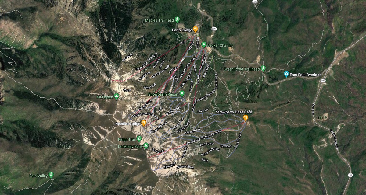
Snowbasin Map-Google Satellite Style

Google Terrain 3D Map Style

Focusing on elevation and topography, Google Terrain Maps offer a precise representation of Snowbasin’s mountainous terrain.  Skiers and snowboarders can easily assess the steepness of slopes and elevation changes, helping them choose runs that match their skill level.

Snowbasin 3D Map-Google Terrain Style 
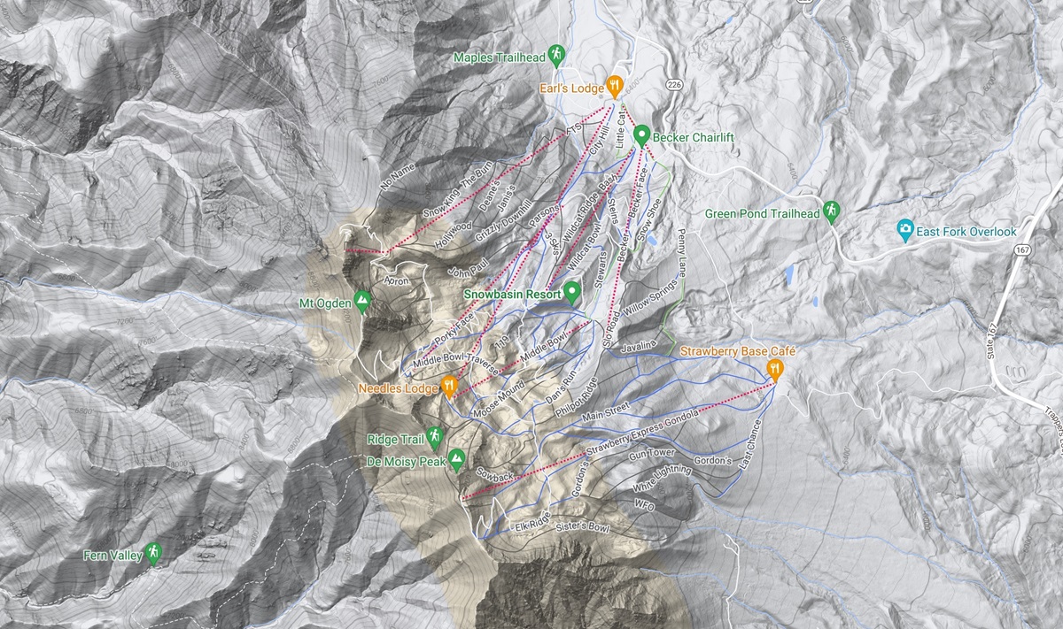
Snowbasin Map-Google Terrain Style

Google Earth 3D Map Style

Google Earth’s 3D capabilities are truly exceptional, and we harness these advanced features to create remarkable 3D raised relief maps that showcase the intricate layout of Snowbasin Ski Resort.  With these cutting-edge tools, we bring the resort’s terrain to life in stunning detail.

Snowbasin 3D Map-Google Earth Style 
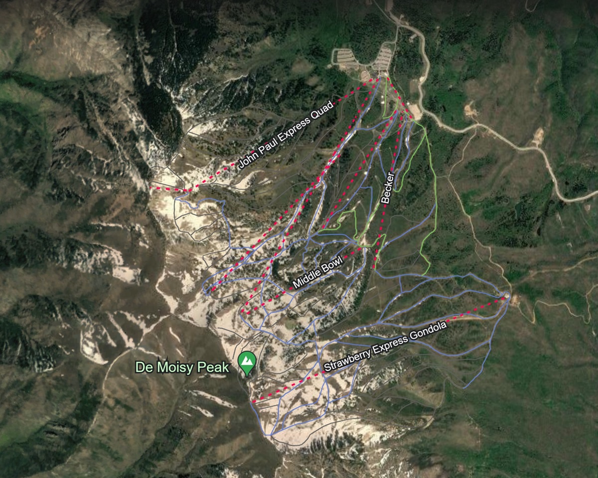
Snowbasin Map-Google Earth Style

Customized 3D Map Styles

Imagine having your own Snowbasin map or design transformed into a stunning 3D masterpiece.  We can turn your vision into a reality, creating a personalized map that caters to your unique adventure.  It’s like having a piece of the mountain designed just for you.

For those who appreciate our existing 3D map styles, we offer the option to supercharge them with personalized features.  Picture this: your map enriched with specific trail information, precise lift locations, intriguing points of interest, and interactive elements that respond to your touch.  These customizations aren’t just enhancements; they’re a game-changer for navigating the mountain.

But it’s not just about convenience; it’s about creating an adventure that’s uniquely yours. These personalized 3D maps are your trusted companions in the world of alpine exploration.  They ensure that every run, every trail, and every decision is made with your preferences in mind, making your mountain navigation not only smooth but also tailored to your desires.


Conclusion

Snowbasin Ski Resort’s 3D raised relief maps aren’t just navigational tools; they are gateways to adventure and inclusivity.  Whether you’re a seasoned pro or a beginner taking your first steps on the slopes, these maps add an extra dimension to your alpine journey.  So, pack your gear and embark on a thrilling adventure through Snowbasin’s magnificent terrain, guided by the enchantment of 3D raised relief maps.  The mountain’s beauty, challenges, and accessibility await you, promising unforgettable moments amidst the pristine winter wonderland of the Wasatch Mountains.

Check out WhiteClouds’ 3D Maps for more information on 3D maps of Snowbasin Ski Resort.   2D Large Canvas Print Snowbasin Maps are also available. 

Contact us today to learn more about our 3D services and how we can help you achieve your goals. 

Get a free quote

Get a Free Quote