Powder Mountain 3D Maps

Powder Mountain 3D Maps

We Build Custom 3D Powder Mountain Maps

Did you know we make

large 3D Maps?

Monterey 3D-printed topography map model with custom pedestal base

Secrets of Powder Mountain 3D Maps

Introducing 3D Maps of Powder Mountain, the ultimate tool for exploring one of nature’s greatest playgrounds in stunning detail.  Nestled amidst the breathtaking peaks of the Wasatch Range in Utah, Powder Mountain is a skier’s paradise, a hiker’s haven, and a year-round sanctuary for outdoor enthusiasts.  With our cutting-edge 3D mapping technology, we invite you to embark on an immersive journey like never before, as we unveil every nook and cranny of this extraordinary destination.

Powder Mountain, often referred to as “Pow Mow,” is renowned for its legendary powder snow and expansive terrain, spanning over 8,000 acres of pristine wilderness.  Whether you’re a seasoned adventurer or a first-time visitor, our 3D Maps offer an unparalleled opportunity to visualize and plan your adventures with unprecedented precision.  From the steep chutes and tree-lined glades that beckon skiers and snowboarders in the winter to the lush hiking trails, mountain biking routes, and serene lakes that come alive in the summer, Powder Mountain is a place where outdoor dreams come true.  Join us as we embark on a journey of exploration and discovery through 3D Maps of Powder Mountain, where every peak, trail, and hidden gem is brought to life in stunning three-dimensional detail.

Unveiling the Beauty in Three Dimensions

One of the most remarkable aspects of 3D Maps for Powder Mountain is their ability to bring the mountain’s breathtaking terrain to life in three dimensions.  Gone are the days of two-dimensional trail maps that provide a mere glimpse of what this majestic destination has to offer.  With 3D Maps, you can now visualize the entire mountain and its surroundings with unparalleled detail and accuracy.

Imagine virtually soaring over the rugged peaks, gliding through the serene valleys, and exploring the hidden nooks and crannies of Powder Mountain from the comfort of your device.  These maps offer a comprehensive representation of the entire resort, allowing you to plan your adventures with precision and confidence.

Park City Topographic Map 1 Park City 3D Raised Relief Map   

Features of 3D Maps for the Powder Mountain Ski Resort

3D raised relief maps prove to be indispensable tools when it comes to comprehending and navigating the captivating alpine landscapes of Powder Mountain Ski Resort in three dimensions.  These innovative maps offer a tactile and lifelike representation of the resort’s terrain, enhancing the way visitors interact with and appreciate the mountainous surroundings.  Let’s explore the unique features of 3D maps tailored to the Powder Mountain experience:

Physical Representation

Crafted from materials such as plastic, resin, or foam, 3D raised relief maps physically manifest Snowbasin’s geographical features, including its majestic peaks, thrilling slopes, and pristine valleys.  These models faithfully mirror the shape and elevation of the resort’s terrain, providing a hands-on experience of the mountain.

Comprehensive Terrain Representation

Our 3D Maps for Powder Mountain provide a complete, three-dimensional representation of the entire resort and its surroundings.  Every peak, valley, and trail is meticulously rendered, allowing you to explore the mountain as if you were there in person.  Whether you’re a skier, snowboarder, hiker, or mountain biker, this comprehensive terrain representation is an invaluable tool for planning your adventures.

Interactive Elevation Profiles

Gain a deeper understanding of Powder Mountain’s topography with interactive elevation profiles.  These profiles allow you to visualize the steepness of slopes, the elevation gain and loss along your chosen routes, and the overall difficulty of trails.  Whether you’re searching for challenging descents or gentle slopes, our elevation profiles help you make informed decisions to match your skill level and preferences.

Topographic Detail

Powder Mountain’s 3D maps meticulously capture the intricate topographic details of the resort, showcasing elevation changes, slope gradients, and contour lines.  Skiers and snowboarders can visually assess the steepness of the runs, the depth of valleys, and the flow of trails, gaining a profound understanding of the resort’s topography.

Scale and Size

Available in various scales and sizes, Powder Mountain’s 3D maps cater to diverse preferences and needs.  From compact tabletop models ideal for educational purposes to grand wall-mounted displays suitable for decorative or planning purposes, visitors can choose the scale that best suits their intended use.

Color and Texture

Color-coded representations on these maps distinguish different types of terrain and land cover, such as vibrant green for forests, serene blue for water bodies, and earthy brown for rugged mountains.  Some maps also incorporate texturing to emulate the unique surface characteristics of Powder Mountain’s landscape.

Customization

Powder Mountain’s 3D maps can be customized to include specific geographic features unique to the resort.  This allows for a personalized representation that includes details such as ski lifts, ski runs, lodges, and other iconic landmarks, making it a valuable tool for both orientation and planning.

Educational Value

Beyond their navigational utility, Powder Mountains’s 3D maps serve as invaluable educational aids, enhancing the understanding of geographical concepts and the resort’s dynamic landscape.  These educational tools find applications in schools, museums, and geographical research, fostering a deeper appreciation for the natural world.

Orientation and Elevation Information

To assist visitors in navigating the resort effectively, Powder Mountain’s 3D maps often incorporate orientation markers like compass roses and north arrows.  They also provide quantitative elevation information through contour lines and numerical values, aiding in height assessment throughout the mountainous terrain.

Interactive Features

Modern 3D relief maps at Powder Mountain Ski Resort may feature interactive elements, including LED lighting to highlight specific areas, touch-sensitive surfaces for accessing additional information, and augmented reality (AR) capabilities for an immersive exploration of the resort’s terrain.

Decorative Purposes

In addition to their educational and functional roles, Powder Mountains’s 3D maps serve as stunning decorative pieces, enhancing the ambiance of homes, offices, and public spaces. Their intricate designs and lifelike representations celebrate the aesthetic beauty of Powder Mountain, making them visually appealing additions to any environment.

3D Maps for Powder Mountain is your gateway to unlocking the full potential of this incredible natural playground. With these robust features at your fingertips, you can confidently plan, navigate, and immerse yourself in the awe-inspiring beauty and excitement that Powder Mountain has to offer.  Whether you’re a seasoned local or a first-time visitor, our 3D Maps are your essential companion for exploring this mountain paradise.

How 3D Maps Are Made: Unveiling the Magic Behind the Scenes

3D maps have revolutionized the way we navigate and explore the world around us, offering immersive and detailed representations of landscapes, cities, and natural wonders. But have you ever wondered how these intricate 3D maps are created?  Let’s take a peek behind the curtain to uncover the magic of 3D map-making.


Data Acquisition: The Foundation of 3D Maps

At the core of any 3D map creation process is the acquisition of spatial data.  This data forms the foundation upon which the 3D map is built.  Several methods are commonly employed to gather this crucial information:

  • Aerial Imagery:  Aerial photography and remote sensing techniques, including LiDAR (Light Detection and Ranging), capture high-resolution images and elevation data from airplanes or drones.  LiDAR, in particular, provides detailed 3D point cloud data by measuring the distance between the sensor and the Earth’s surface.

  • Satellite Imagery:  Satellite-based remote sensing technologies collect vast amounts of data covering large areas.  This data includes color imagery, infrared imagery, and elevation data, allowing for a comprehensive view of the terrain.

  • Ground-Based Surveys:  Surveyors use terrestrial LiDAR scanners, GPS technology, and other instruments to collect precise data from the ground. This data is often used to complement and refine aerial or satellite data.

Data Processing: Transforming Raw Data into 3D Models

Once the raw data is collected, it undergoes extensive processing to convert it into usable 3D models.  This processing includes:

  • Data Alignment:  Merging data from various sources and ensuring that it is accurately aligned in a common coordinate system is a crucial step.  This alignment ensures that the 3D map accurately represents the real-world terrain.

  • Point Cloud Processing:  For LiDAR data, point clouds are generated, where each point represents a specific location in 3D space.  Filtering and classification algorithms are used to separate ground points from non-ground points (such as vegetation or buildings).

  • Mesh Generation:  To create a more detailed 3D representation, the point cloud is converted into a mesh.  This mesh consists of interconnected triangles that form the surface of the terrain.

  • Texture Mapping:  Aerial and satellite images are draped onto the 3D mesh to provide color and texture, making the map visually appealing and realistic.

Visualization and Interaction: Making 3D Maps User-Friendly

Creating a 3D map is not just about data; it’s about making it accessible and user-friendly. Here’s how:

  • User Interface Design:  Designing an intuitive user interface is crucial to allow users to interact with the 3D map effectively.  This includes navigation controls, search functions, and overlay options.

  • Web-Based Platforms:  Many 3D maps are accessible through web-based platforms or dedicated apps, making them available to a wide audience via computers, smartphones, and tablets.

  • Customization:  Users often have the ability to customize their 3D map experience by choosing different layers, map styles, and viewing options to suit their needs and preferences.

3D maps are a fascinating blend of data collection, processing, visualization, and technology integration.  They provide us with powerful tools for navigation, exploration, and understanding of our world, and they continue to evolve, offering new possibilities for both practical and recreational applications. 

Top 10 Lifts at Powder Mountain

Navigating the vast and exhilarating terrain of Powder Mountain is made effortless and enjoyable with our 3D Maps.  Let’s explore the top 10 lifts at this renowned resort.  These lifts provide access to some of the best terrain, promising unforgettable experiences for all visitors.

  • Hidden Lake Express:  Accessing some of the mountain’s steepest and most challenging terrain, this high-speed quad lift is a favorite among expert skiers and snowboarders.

  • Paradise Express:  Serving as a gateway to the Powder Country and Lefty’s area, this lift offers a variety of terrain, from powder-filled glades to groomed runs.

  • Lightning Ridge:  For the adventurous, Lightning Ridge offers access to powder stashes and thrilling tree runs, providing a backcountry-like experience within the resort boundaries.

  • Sundown Lift:  Perfect for intermediate skiers and snowboarders, Sundown provides access to well-groomed slopes and beautiful views of the surrounding area.

  • Hidden Lake Lift:  An essential lift for accessing the challenging terrain of James Peak, Hidden Lake Lift is a must-ride for advanced riders.

  • Timberline Lift:  Serving as a family-friendly hub, this lift provides access to beginner and intermediate runs, making it an ideal choice for those new to skiing or snowboarding.

  • Powder Country Shuttle:  A unique experience, the Powder Country Shuttle takes you to the boundary of Powder Mountain, where you can enjoy endless powder runs in pristine backcountry terrain.

  • Sunrise Poma:  An excellent lift for beginners, this surface lift is perfect for honing your skills on gentle slopes.

  • Wildcat Lift:  Access the charming village and terrain parks via the Wildcat Lift, which provides a variety of runs suitable for all skill levels.

  • Rusty Shovel:  This terrain park lift allows freestyle enthusiasts to access the features and jumps of Powder Mountain’s terrain parks, catering to riders of all abilities.

By utilizing our 3D Maps and exploring these top lifts, you’ll be well on your way to making the most of your visit to Powder Mountain, experiencing the thrill of the slopes, the serenity of the backcountry, and the beauty of this remarkable mountain destination.

Top 10 Runs at Powder Mountain

Navigating the expansive and diverse terrain of Powder Mountain has never been easier, thanks to our innovative 3D Maps.  Whether you’re a seasoned rider or a first-time visitor, these maps are your key to unlocking the full potential of your adventure.   Now, let’s explore the top 10 runs at Powder Mountain, each offering its own unique charm and challenges for riders of all levels.

  • Lightning Ridge:  A renowned black diamond run, Lightning Ridge offers challenging terrain with powder stashes, glades, and breathtaking views.
  • Powder Country:  For those seeking a backcountry-like experience within the resort boundaries, Powder Country offers pristine powder runs accessible by the Powder Country Shuttle.
  • Lefty’s:  A favorite among advanced skiers and snowboarders, Lefty’s features steep chutes and thrilling tree runs, promising an adrenaline-packed adventure.
  • Paradise:  Offering a mix of groomed trails and powder-filled glades, Paradise is ideal for riders looking for a diverse range of terrain.
  • James Peak:  Accessible via the Hidden Lake Lift, James Peak boasts expert-level terrain with challenging tree skiing and steep descents.
  • Paradise Woods:  A hidden gem within Powder Mountain, Paradise Woods is a beautiful glade run with untouched powder and tranquil surroundings.
  • Fay’s Glade:  Perfect for intermediate riders, Fay’s Glade offers a delightful mix of tree skiing and open slopes, making it an enjoyable and approachable run.
  • Sundown:  A cruiser’s dream, Sundown features well-groomed slopes with scenic views, making it a fantastic choice for skiers and riders of all levels.
  • Blazing Saddles:  A terrain park enthusiast’s haven, Blazing Saddles offers a range of features and jumps to challenge your freestyle skills.
  • Timberline:  Ideal for beginners and families, Timberline provides gentle, beginner-friendly slopes, creating a welcoming environment for those new to skiing or snowboarding.

With our 3D Maps and this list of top runs, you’re well-equipped to embark on an unforgettable adventure at Powder Mountain.  Whether you’re chasing steep chutes, pristine powder, or leisurely groomers, these resources will help you make the most of your time on the mountain, ensuring an incredible experience every step of the way.

3D Map Styles for Powder Mountain

Exploring Powder Mountain is a dynamic and personalized experience, and our 3D Maps offer a variety of styles to cater to different preferences and needs. These map styles not only provide visual appeal but also serve as essential tools for navigating the diverse terrain.  Let’s dive into the four primary 3D map styles available for Powder Mountain:

Google Maps Satellite Style

Overview:  The Google Maps Satellite Style brings a high-resolution, bird’s-eye view of Powder Mountain directly to your fingertips. This style harnesses satellite imagery to provide an accurate representation of the mountain’s landscape.

Benefits:  With this style, you’ll have a clear understanding of the mountain’s natural features, including peaks, valleys, forests, and lakes. It’s particularly useful for getting an overview of the entire area and identifying key landmarks.

Powder Mountain Map - Google Maps Satellite Style 
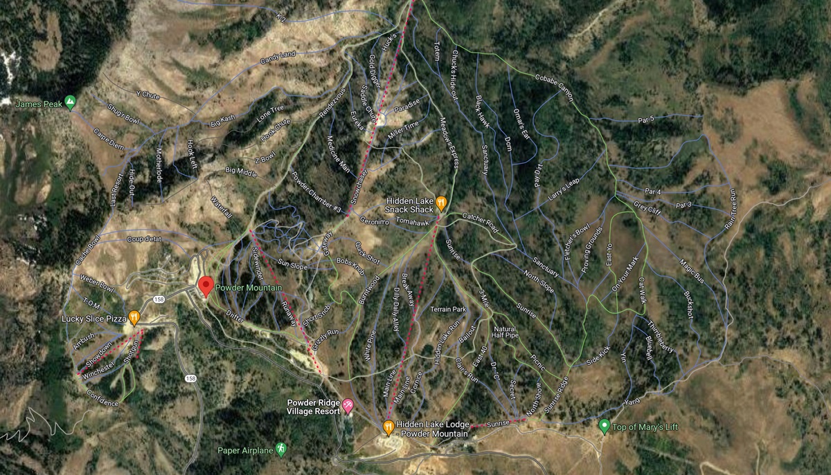
Powder Mountain Map – Google Maps Satellite Style


Google Maps Terrain Style

Overview:  The Google Maps Terrain Style combines elevation data with topographic contours, providing a detailed representation of the mountain’s terrain.  This style offers a valuable perspective on the elevation changes and geographical features of Powder Mountain.

Benefits: For those seeking a deeper understanding of the mountain’s topography, the Terrain Style is a valuable resource.  It allows you to visualize elevation changes and plan routes based on the ruggedness of the terrain.  This style is especially helpful for hikers and mountain bikers.

Powder Mountain Map - Google Maps Terrain Style 
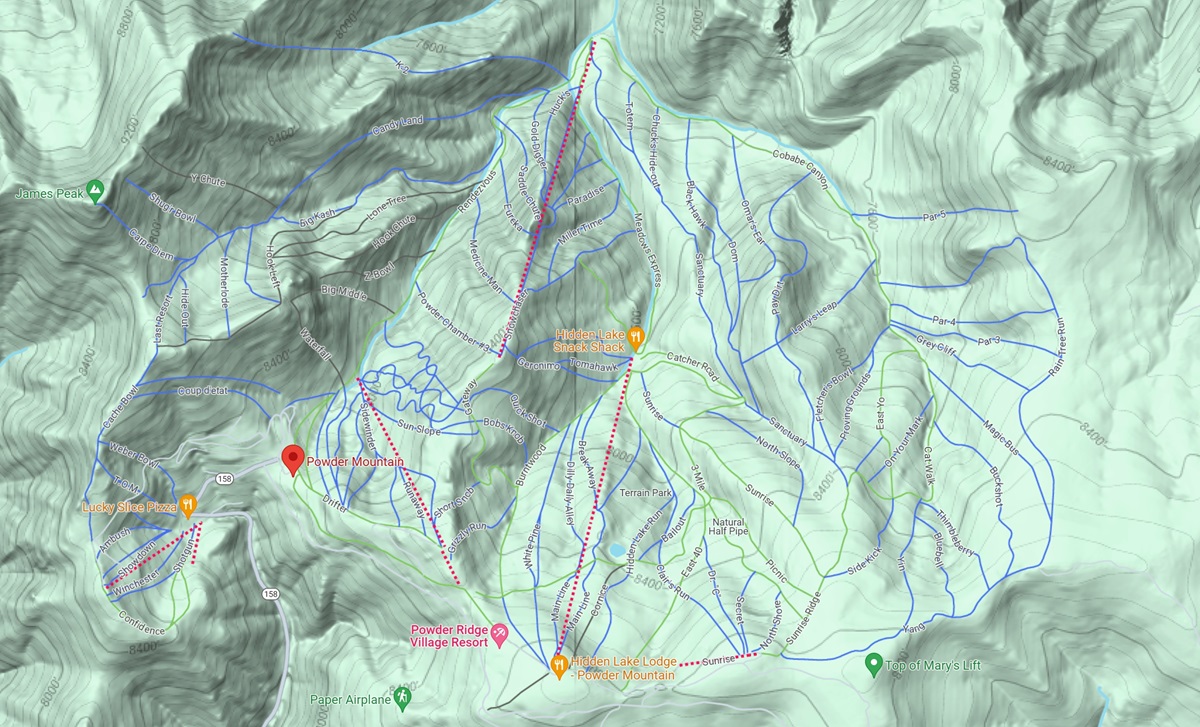
Powder Mountain Map – Google Maps Terrain Style


Google Earth Style

Overview:  The Google Earth Style offers an immersive, three-dimensional view of Powder Mountain, allowing you to explore the mountain in a visually captivating manner.  It combines satellite imagery with 3D terrain modeling.

Benefits:  This style provides a realistic, interactive experience as if you were soaring above the mountain.  It’s a fantastic way to appreciate the beauty of Powder Mountain from all angles.

Powder Mountain Map - Google Earth Style 
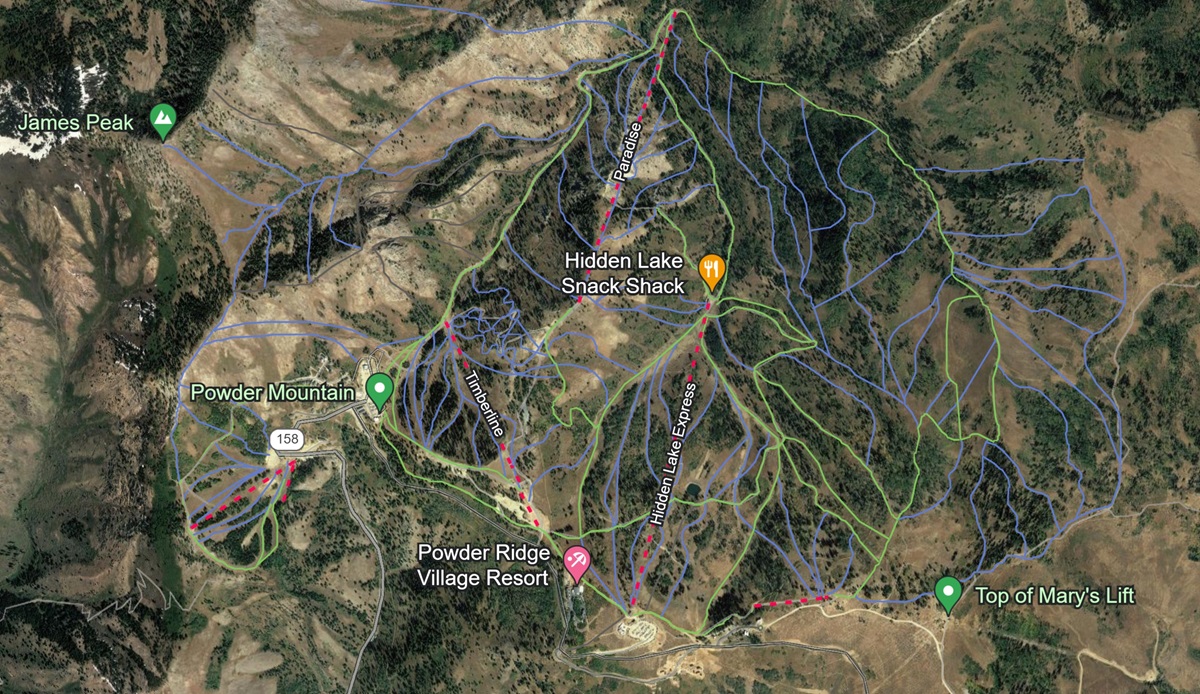
Powder Mountain Map – Google Earth Style


Customized Map Styles

Overview:  Customized Styles allow you to tailor your 3D map experience at Powder Mountain to your specific preferences.  You can adjust the map’s appearance, such as choosing different color schemes, adding labels, and highlighting specific points of interest.

Benefits:  With Customized Styles, you have the freedom to personalize your map for your unique needs.  Whether you want to focus on certain trails, highlight amenities, or emphasize specific areas of the mountain, customization provides a powerful tool to enhance your planning and navigation.

Each of these 3D map styles serves a distinct purpose, catering to a wide range of outdoor enthusiasts.  Whether you’re an avid skier, snowboarder, hiker, or mountain biker, these styles offer valuable insights and visualization tools to make the most of your adventure at Powder Mountain.  Whether you prefer the realism of Google Earth, the detailed topography of Terrain Style, or your own customized approach, our 3D Maps ensure that you have the resources you need to explore this magnificent destination to the fullest.

Unlocking the Beauty of Powder Mountain with 3D Maps

In the world of outdoor adventure, Powder Mountain stands as a pristine and captivating playground for enthusiasts of all kinds.  Nestled among the stunning peaks of the Wasatch Range, this Utah gem beckons with its breathtaking landscapes, thrilling slopes, and tranquil wilderness.  As we conclude our journey through the dynamic world of 3D Maps of Powder Mountain, it becomes clear that this innovative tool is your key to unlocking the full potential of this remarkable destination.

Our 3D Maps for Powder Mountain offer more than just visual appeal; they empower you with the knowledge, insights, and resources necessary to make the most of your experience.  From high-resolution satellite imagery to topographic terrain modeling, our map styles provide a multifaceted perspective of the mountain’s beauty and challenges. Whether you’re seeking the thrill of steep chutes, the serenity of hidden glades, or the leisurely joys of groomed trails, these maps have you covered.

But beyond aesthetics, our 3D Maps offer functionality.  They assist you in planning your adventures, from skiing and snowboarding in the winter to hiking and mountain biking in the summer.  Elevation profiles, real-time weather updates, and trail planning tools ensure that you’re prepared for every twist and turn of the mountain.  Points of interest, amenities, and user-generated content create a sense of community, helping you connect with like-minded adventurers and enhancing your overall experience.

Welcome to a world where mountains meet technology, and nature’s wonders are brought to life in three dimensions.  Embrace the beauty, conquer the challenges, and savor the memories, all with the help of our powerful and immersive mapping tool.  Your adventure awaits – let the exploration begin! 

Check out WhiteClouds’ 3D Maps for more information on 3D maps of Powder Mountain Ski Resort.   2D Large Canvas Print Powder Mountain Maps are also available. 

Contact us today to learn more about our 3D services and how we can help you achieve your goals. Maps     

Get a free quote

Get a Free Quote