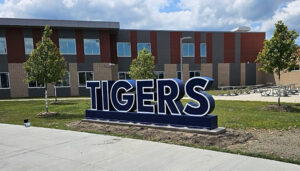
Month: September 2024

Warrensville Heights High School Tigers, Ohio Metal Letters on campus

Dimensional Letters

Dimensional letters bring bold, eye-catching depth to any space. From corporate lobbies to outdoor facades, these 3D signs create lasting impressions with their sleek design and striking visibility. Combining timeless elegance with modern innovation, dimensional letters elevate branding and wayfinding, making environments more engaging, professional, and memorable.

Read More »
Malaysia Watershed Maps

Malaysia Watershed Maps

Malaysia’s watersheds are crucial for agriculture, energy, and ecosystems. This blog explores their importance, challenges, and how 3D watershed maps help manage water resources, reduce pollution, and support conservation efforts. Learn how mapping technologies contribute to ensuring the sustainability of Malaysia’s water systems amidst climate change and increasing water demands.

Read More »
Hungary Watershed Maps

Hungary Watershed Maps

Hungary’s watersheds are crucial for agriculture, ecology, and water supply. This blog explores the challenges they face, including pollution and climate change, and how 3D watershed maps aid in sustainable water management. Learn how mapping technologies help manage water quality, predict floods, and support conservation efforts, ensuring Hungary’s watersheds continue to provide vital resources and remain resilient for future generations.

Read More »
Norway Watershed Maps

Norway Watershed Maps

Norway’s watersheds, including the Glomma and Drammen River basins, are crucial for hydropower, agriculture, and ecosystems. This blog explores how modern technologies like 3D mapping, GIS, and remote sensing help manage and monitor these systems. These tools are essential for ensuring sustainable water use, addressing challenges like climate change, flood risks, and growing demand for water resources, while protecting ecosystems for future generations.

Read More »
Ethiopia Watershed Maps

Ethiopia Watershed Maps

Ethiopia’s watershed maps are essential for managing river systems, predicting floods, and ensuring sustainable water use. These maps guide water allocation for agriculture, industry, and communities while addressing climate change challenges. By monitoring river flow, groundwater levels, and water quality, they support flood prevention, efficient water distribution, and ecosystem protection, ensuring that Ethiopia’s water resources are preserved for future generations.

Read More »
Saint Vincent and the Grenadines Watershed Maps

Saint Vincent and the Grenadines Watershed Maps

Saint Vincent and the Grenadines’ watersheds, such as the Roseau and Rabacca River Basins, are essential for agriculture and ecosystems. Learn how modern technologies like 3D mapping, GIS, and remote sensing help manage these systems, ensuring sustainable water use and addressing challenges like water scarcity, climate change, and population growth.

Read More »
Andorra Watershed Maps

Andorra Watershed Maps

Discover Andorra’s watersheds, essential for agriculture, hydroelectric power, and biodiversity. Learn about the geography and hydrology of key rivers, including the Valira and Gran Valira. Explore how 3D mapping technologies are enhancing water resource management by providing valuable insights into water flow, land use, and environmental changes. These tools help ensure sustainable management of Andorra’s water resources and protect its ecosystems for the future.

Read More »
Brahmani-Baitarani Watershed Map

Brahmani-Baitarani Watershed Map

Explore the Brahmani-Baitarani Watershed, an essential resource in eastern India. Learn about its geography, hydrology, and rich ecosystems, and how advanced 3D mapping technologies are helping to manage and conserve the watershed. The basin is critical for agriculture, water supply, and biodiversity, but faces significant challenges. Sustainable management and conservation efforts, supported by cutting-edge mapping tools, are vital for its long-term health.

Read More »
Chad Watershed Maps

Chad Watershed Maps

Chad’s watershed maps are crucial for managing river systems, predicting floods, and ensuring sustainable water use. These maps help allocate water for agriculture, drinking, and industry while addressing climate change and water scarcity. By monitoring water availability and flood risks, watershed maps support efficient resource distribution and flood protection, ensuring that Chad’s water resources remain viable for future generations.

Read More »
Antigua and Barbuda Watershed Maps

Antigua and Barbuda Watershed Maps

Explore Antigua and Barbuda’s watersheds, which are vital for agriculture, tourism, and ecosystems. Learn about key river systems like the Potworks and McKinnon’s watersheds, and how 3D mapping technologies are enhancing water resource management. These tools provide critical insights into water flow, land use, and environmental health, helping ensure sustainable practices that protect the country’s freshwater resources and safeguard its future.

Read More »
Bulgaria Watershed Maps

Bulgaria Watershed Maps

Bulgaria’s watershed maps help manage water resources, predict floods, and ensure sustainable water use across the country. These maps are vital for agriculture, industry, and ecosystem conservation, as well as for adapting to the challenges of climate change.

Read More »
Belarus Watershed Maps

Belarus Watershed Maps

Belarus’ watershed maps help manage the country’s rivers, lakes, and wetlands. These maps assist in flood prevention, water conservation, and sustainable use of water resources, ensuring a resilient future amid climate change.

Read More »
Qatar Watershed Maps

Qatar Watershed Maps

Qatar’s watersheds, such as the Al Daayen Basin, are crucial for agriculture, ecosystems, and water management. This blog explores how modern technologies like 3D mapping, GIS, and remote sensing help monitor and manage these systems. These tools are vital for ensuring sustainable water use, addressing challenges such as water scarcity, climate change, and growing demand for resources, while protecting Qatar’s ecosystems.

Read More »
Germany Watershed Maps

Germany Watershed Maps

Germany’s watershed maps are essential for managing river systems, predicting floods, and ensuring sustainable water use. These maps help allocate water for agriculture, industry, and communities while addressing climate change challenges. By monitoring river flow, groundwater levels, and water quality, they support flood prevention, efficient water distribution, and ecosystem protection, ensuring that Germany’s water resources are preserved for future generations.

Read More »
Eswatini Watershed Maps

Eswatini Watershed Maps

Eswatini’s watershed maps are crucial for managing river systems, predicting floods, and ensuring sustainable water use. These maps help allocate water for agriculture, industry, and communities while addressing climate change challenges. By monitoring river flow, groundwater levels, and water quality, they support flood prevention, efficient water distribution, and ecosystem protection, ensuring that Eswatini’s water resources are preserved for future generations.

Read More »

Get a Free Quote on a Custom 3D Billboard

Get a Free Quote