- All
- 3D Printing
- Architecture
- Character Models
- Characters
- Entertainment
- Foam
- Health Care
- Ideas-Topo
- Letters
- Listicle
- Logo
- Maps
- Mars
- Props
- Replicas
- Selfie
- Signage
- Sports
- Statues
- Thrones
- Top-10
- Trade Show

Mount St. Joseph University Giant Adirondack Chair
Towering 7.5 feet tall and over 10 feet wide, Mount St. Joseph University’s giant Adirondack chair shines in bold yellow and blue. Emblazoned with the ...

Giant Stool
The giant stool transforms a humble everyday object into a larger-than-life icon of art, design, and imagination. From public landmarks to playful interiors, these oversized ...

Kidney Foundation Custom Display: A Sculpture of Hope
At the Kidney Foundation trade show, a blank foam sculpture transformed into a vibrant masterpiece as attendees placed 3,000 flowers into its surface. This custom ...

Flagstaff Hiking Boot Billboard: A Monument to Adventure
Towering nine feet tall and twelve feet wide, the Flagstaff Hiking Boot Billboard is more than advertising—it’s an adventure in itself. Hand-sculpted from foam and ...

Giant Cube Seat
Bold, modern, and endlessly versatile, the giant cube seat transforms a simple shape into a striking design statement. From public parks to sleek interiors, these ...

Giant Bean Bag Couch
The giant bean bag couch takes comfort to a whole new level—blending the playful charm of a bean bag with the size and function of ...

Giant Bar Stool
Step into a world where the ordinary becomes extraordinary with the giant bar stool. Towering high above the everyday, these oversized creations mix artistry, engineering, ...

Giant High Chair
A giant high chair transforms an everyday object into a larger-than-life experience. Playful and nostalgic, it invites adults to feel small again and children to ...

Giant Iron Man Statue
A giant Iron Man statue is more than fandom—it’s a symbol of technology, courage, and modern mythology. From dazzling red-and-gold armor to glowing arc reactors, ...

Giant Outdoor Lounger
A giant outdoor lounger transforms any patio, garden, or resort into a destination of pure relaxation. Oversized and inviting, it offers space for families, couples, ...

Giant Superman Statue
A giant Superman statue is more than a tribute to a comic book hero—it’s a monumental symbol of hope, justice, and inspiration. From digital design ...

Giant Hammock Stand
A giant hammock stand transforms relaxation into a shared, unforgettable experience. Oversized and striking, it invites families, friends, and travelers to sway together in comfort. ...
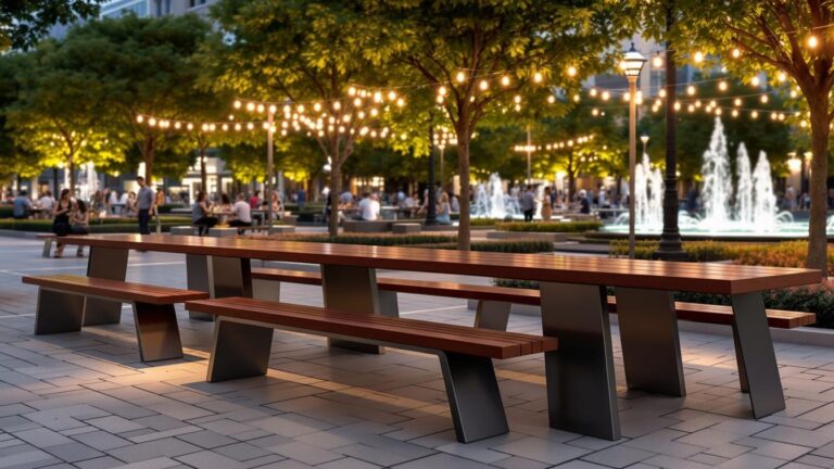
Giant Picnic Bench
A giant picnic bench turns ordinary outdoor dining into an extraordinary experience. These oversized tables spark wonder, invite connection, and create unforgettable memories for families, ...
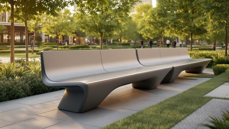
Giant Garden Bench
A giant garden bench transforms outdoor spaces into whimsical retreats and community hubs. More than seating, it’s a playful statement that invites reflection, conversation, and ...

Giant Porch Swing
A giant porch swing transforms any outdoor space into a cozy retreat and community hub. More than oversized seating, it blends nostalgia, comfort, and style ...

Giant Patio Chair
Giant patio chairs turn ordinary outdoor spaces into extraordinary experiences. Towering in scale and bursting with charm, they invite comfort, laughter, and curiosity. From backyard ...

Giant Trump Statue
A giant Trump statue is more than a monument—it’s a spectacle. From bold fabrication techniques to viral pop culture moments, these towering figures ignite debate, ...

Giant Buddha Statue
A giant Buddha statue is more than a monument—it’s a spiritual beacon, cultural masterpiece, and engineering wonder. From ancient cliff carvings to modern golden giants, ...

Giant Credenza
Step into the world of giant credenzas—furniture that blends history, artistry, and modern elegance. More than storage, these commanding pieces anchor dining rooms, offices, and ...
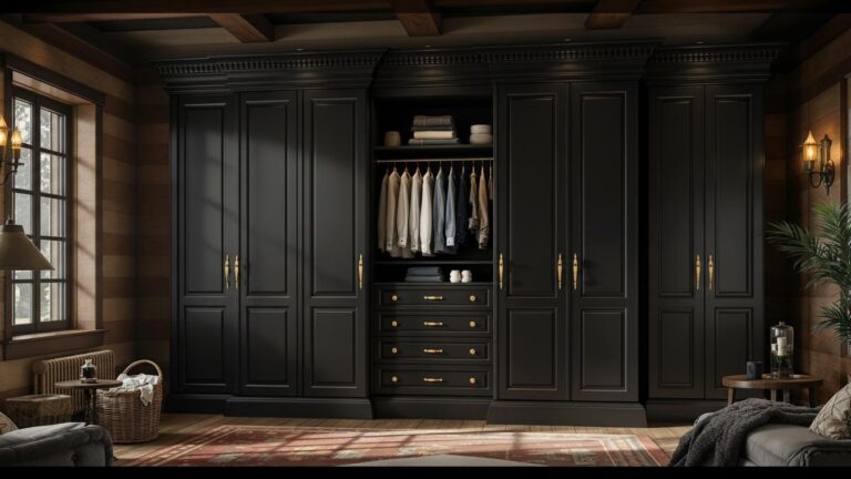
Giant Wardrobe
Step inside the world of giant wardrobes—where furniture becomes art, history, and even mystery. From medieval castles to modern homes, these towering masterpieces are more ...

Giant Chest of Drawers
From historic estates to roadside landmarks, the giant chest of drawers transforms everyday storage into a symbol of heritage, artistry, and imagination. These oversized icons ...
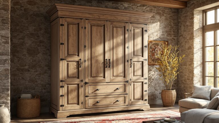
Giant Armoire
Step into the world of the giant armoire—a towering blend of history, craftsmanship, and elegance. More than storage, it’s a statement piece that transforms any ...
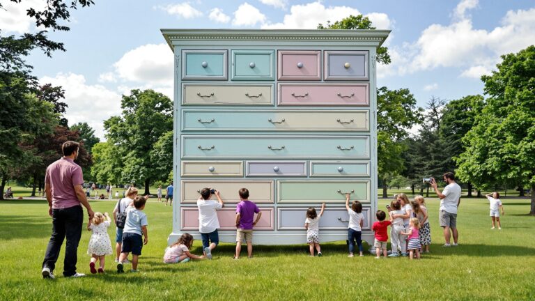
Giant Dresser
Giant dressers transform everyday storage into monumental art. From roadside landmarks to cultural icons, these oversized creations celebrate craftsmanship, heritage, and whimsy. Towering above their ...

Giant Cabinet
Giant cabinets turn storage into art, blending functionality with bold design. These oversized statement pieces are not just for holding belongings—they’re conversation starters and works ...

Giant Bookshelf
Transform your space with a giant bookshelf! More than just a storage solution, it’s a stylish statement piece that organizes, showcases, and elevates your room. ...

Giant Nightstand
Transform your bedroom with a giant nightstand! Offering extra storage, ample surface space, and stylish designs, it’s the perfect solution for modern living. Maximize your ...
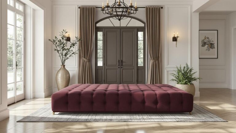
Giant Ottoman
Elevate your home with a giant ottoman! Offering unmatched comfort, style, and versatility, it serves as extra seating, a cozy footrest, and even hidden storage.

Giant Chaise Lounge
Transform your home with a giant chaise lounge! Offering unparalleled comfort, style, and versatility, it’s the perfect spot to relax, read, or entertain in luxury.