
Unfolding the Terrain: The Topographical Map of Europe
Europe, the cradle of Western civilization and a crossroads of cultures, presents an astounding tapestry of landscapes, from the icy fjords of Scandinavia to the sun-kissed shores of the Mediterranean. A topographical map of Europe unfurls these physical contours, offering a meticulous rendition of this diverse terrain. Journey with us as we navigate through this detailed landscape guide, discovering the high peaks, rolling plains, and intricate river systems that define Europe.
The Genesis of Topography: A Brief Primer
Topographical maps are distinct from their cartographic siblings. Rather than just tracing political borders or marking cities, these maps delineate the natural terrain using contour lines, shading, and symbology. Each line, shade, and symbol narrates the story of the land’s elevation, slope, and features.
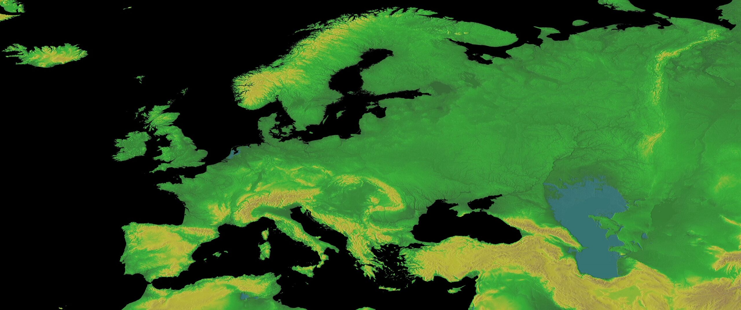
The European Canvas: Mountain Ranges and Peaks
Europe is a topographer’s dream, punctuated by grand mountain ranges.
The Alps: Dominating Central Europe, they stretch across France, Switzerland, Italy, and Austria. Mont Blanc, the highest peak, stands as a sentinel, overlooking the panorama below.
The Carpathians: Sweeping through Eastern Europe, this range serves as the backdrop for tales from Romania’s Transylvania.
The Pyrenees: This natural border between France and Spain boasts rugged peaks and lush valleys.
The Balkans: Traversing southeastern Europe, these mountains are a testament to the continent’s complex geology.
Plains, Plateaus, and Lowlands
Europe isn’t just about towering peaks. It also features vast stretches of plains and plateaus:
The Northern European Plain: Extending from France’s coast to the Ural Mountains in Russia, it’s a region of fertile soils and pivotal historical events.
The Meseta Central: This plateau in Spain offers a stark contrast with its sun-baked landscape and rich vineyards.
The Hungarian Plain : Also known as the Pannonian Basin, this flat terrain is Eastern Europe’s agricultural heartland.
A Mosaic of Rivers and Lakes
Waterways have long dictated Europe’s trade, migrations, and settlements.
The Danube: Europe’s second-longest river, it’s a lifeline for ten countries, starting from Germany’s Black Forest to the Black Sea.
The Volga: Flowing through Russia, it holds the title of Europe’s longest river, sustaining numerous towns and industries.
Lake Ladoga and Lake Onega : Nestled in Russia, these freshwater bodies are European giants, holding tales of time and nature.
Islands and Archipelagos: Europe’s Maritime Jewels
From the British Isles in the Northwest to the Greek Islands in the Aegean, Europe’s islands present diverse topographies:
Iceland: A land of glaciers, volcanoes, and geysers, its topography is as dynamic as its geothermal energy.
The Azores: Located in the Atlantic, these Portuguese islands are marked by steep cliffs, rolling pastures, and volcanic landscapes.
The Balearics: Featuring Mallorca, Menorca, and Ibiza, their terrains vary from sandy beaches to limestone mountains.
Unearthing Historical Insights from Topography
The European landscape isn’t just about physical features. It’s intertwined with history. Battlefields, trade routes, ancient settlements—all were influenced by the lay of the land.
The Ural Mountains: Historically, they’ve separated European Russia from its Asian part.
The Rhine: This river has been a key trade and defensive route since Roman times.
The Bosphorus Strait: Connecting Asia and Europe, it has been coveted for its strategic significance.
A topographical map of Europe is a rich narrative, weaving tales of geology, history, and humanity’s adaptability. It’s a document testifying to the continent’s resilience, diversity, and grandeur.
As you trace the contours on such a map, remember that each line holds stories of epic migrations, battles, and the timeless dance of Earth’s ever-evolving face. So, whether you’re a traveler, student, or just a curious soul, this map promises a journey of discovery, ensuring Europe’s landscapes and legacies are etched into your heart.
Contact us today to learn more about our 3D services and how we can help you achieve your goals.