
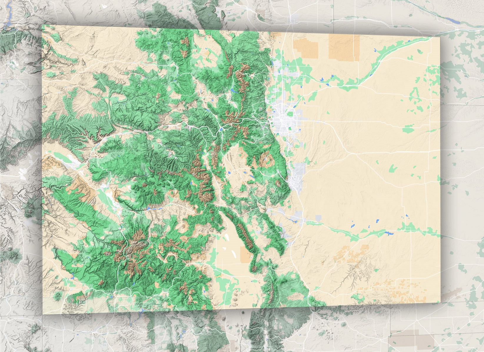
Terrain Map of Colorado: Unraveling the Secrets of the Centennial State
The state of Colorado is nothing short of a geographical wonder, a captivating mosaic where plains, plateaus, and peaks converge to form an awe-inspiring tableau. This land, where the flat horizons of the plains rise dramatically to meet the snow-clad summits, exemplifies nature’s unparalleled craftsmanship. To truly appreciate the multifaceted beauty of the Centennial State, one must embark on a journey through its terrain map, where each elevation, each twist and turn, unravels a new chapter of its profound geologic narrative.
Understanding Terrain Maps: The Prelude
To fully grasp Colorado’s rich topography, it’s essential first to understand the concept of a terrain or topographic map. At its core, a terrain map serves as a three-dimensional representation of a land surface, charted meticulously with contour lines. These lines, connecting points of similar elevation, create a visual guide for interpreting the rise and fall of the Earth’s surface. In the context of Colorado, a state known for its sweeping elevation changes, the terrain map becomes a vital tool. It offers a detailed, layered view, allowing us to traverse its valleys, ascend its mountains, and explore its plateaus, all from the comfort of our imagination.
The Eastern Plains: A Horizon of Stories
Initiating our exploration from the eastern vantage, the vast expanses of Colorado’s plains beckon. Far from being a monotonous stretch, this landscape is a vibrant tapestry of ecosystems. Grasslands sway in the breeze, interspersed with buttes and canyons that carve out the terrain, creating a dynamic ecosystem. Diving deeper, we uncover tales of ancient seas that once dominated this landscape, whispers of indigenous tribes that revered this land, and echoes of the early settlers who sought new beginnings under its expansive sky.
The Foothills: Nature’s Prelude to Grandeur
Progressing westward, the plains subtly transform into the foothills, hinting at the majestic Rockies’ impending spectacle. This intermediary terrain, marked by its gentle slopes, winding rivers, and occasional rugged outcrops, serves as home to thriving cities like Denver, Boulder, and Fort Collins. These urban jewels, while bustling with modernity, offer serene, panoramic views of the mountains, blending civilization with nature effortlessly.
The Rockies: Colorado’s Geographical Crown
Emerging as the undeniable highlight of Colorado’s terrain are the Rocky Mountains. These aren’t just towering peaks; they are ancient storytellers, narrating tales of epochs gone by and the relentless tectonic forces that birthed them. Mount Elbert, Pikes Peak, and a host of other ‘Fourteeners’ challenge the sky, while nestled amidst them are verdant valleys and pristine alpine lakes, adding layers to this topographical masterpiece.
The Intermontane Basins: Nature’s Serene Amphitheaters
Nestled within the Rockies’ embrace are Colorado’s intermontane basins. These elevated plains, like North Park, Middle Park, and South Park, present a tranquil juxtaposition to the surrounding ruggedness. Serving as fertile grounds for ranching and agriculture, they offer lush, green respite amidst the dominating mountains, exemplifying the state’s diverse landscape.
The Colorado Plateau: Where Erosion Crafts Beauty
The state’s western realms introduce us to the rugged Colorado Plateau. A confirmation to the power of water and time, the plateau is a symphony of canyons, mesas, and buttes. As the Colorado River snakes its way through, it has, over millennia, carved iconic landscapes like the Black Canyon of the Gunnison, showcasing the land’s stratified history.
The High Desert Lands: Sand, Sun, and Snow
Venturing further south, Colorado reveals yet another facet – its high desert landscapes. Amidst this arid backdrop, sand dunes rise, sculpted by wind and time. Places like the Great Sand Dunes National Park blur the boundaries between desert vastness and snowy mountain peaks, crafting a surreal, contrasting beauty.
The Western Slope: A Mélange of Landscapes
Beyond the Continental Divide lies the Western Slope, an eclectic blend of Rockies, plateaus, and fertile basins. Towns such as Grand Junction serve as vibrant hubs, surrounded by nature’s wonders, from flourishing vineyards and orchards to the raw, untouched beauty of areas like the Colorado National Monument.
Celebrating Colorado’s Diverse Canvas
Colorado’s topography is a fluid dance between flatlands, elevations, valleys, and peaks. As we traverse this geographical marvel, we realize that each segment, whether it’s the soft murmurs of the plains or the echoing canyons, resonates with a unique cadence.
A Geographical Odyssey
The terrain map of Colorado doesn’t merely chart out geographical landmarks; it paints a vivid portrait of the state’s soul. Each contour, each elevation, each valley and peak, narrates a tale, waiting for intrepid explorers to discover and revel in its beauty. As you journey through this land, take a moment to listen, for the land itself has countless stories to share.
Check out WhiteClouds’ 3D Maps for more information on terrain maps of Colorado. 2D Canvas Print Terrain Maps of Colorado are also available.
Contact us today to learn more about our 3D services and how we can help you achieve your goals.