
Terrain Map of California: A Diverse and Spectacular Landscape
When one thinks of California, an array of vibrant images come to mind: Hollywood’s glitzy boulevards, San Francisco’s iconic Golden Gate, the sun-kissed beaches of Southern California, and the captivating vineyards of Napa Valley. But these iconic sights are just a fragment of what the state has to offer. To truly appreciate California’s grandeur, we must first dive into its terrain map.
What is a Terrain Map?
Before we embark on this geographical journey, let’s clarify: what exactly is a terrain map? A terrain map, often referred to as a topographic map, vividly displays the physical features and elevations of a specific region, translating the three-dimensional complexities of landscapes onto a two-dimensional plane. With the use of contour lines, colors, shading, and occasionally relief imagery, it brings forth intricate details about the Earth’s surface. These maps aren’t just for admiration; they serve as critical tools for a plethora of professionals – from geologists studying land formations to urban planners mapping out city expansions.
With that in mind, let’s delve deep into the mesmerizing terrains that make up the Golden State.
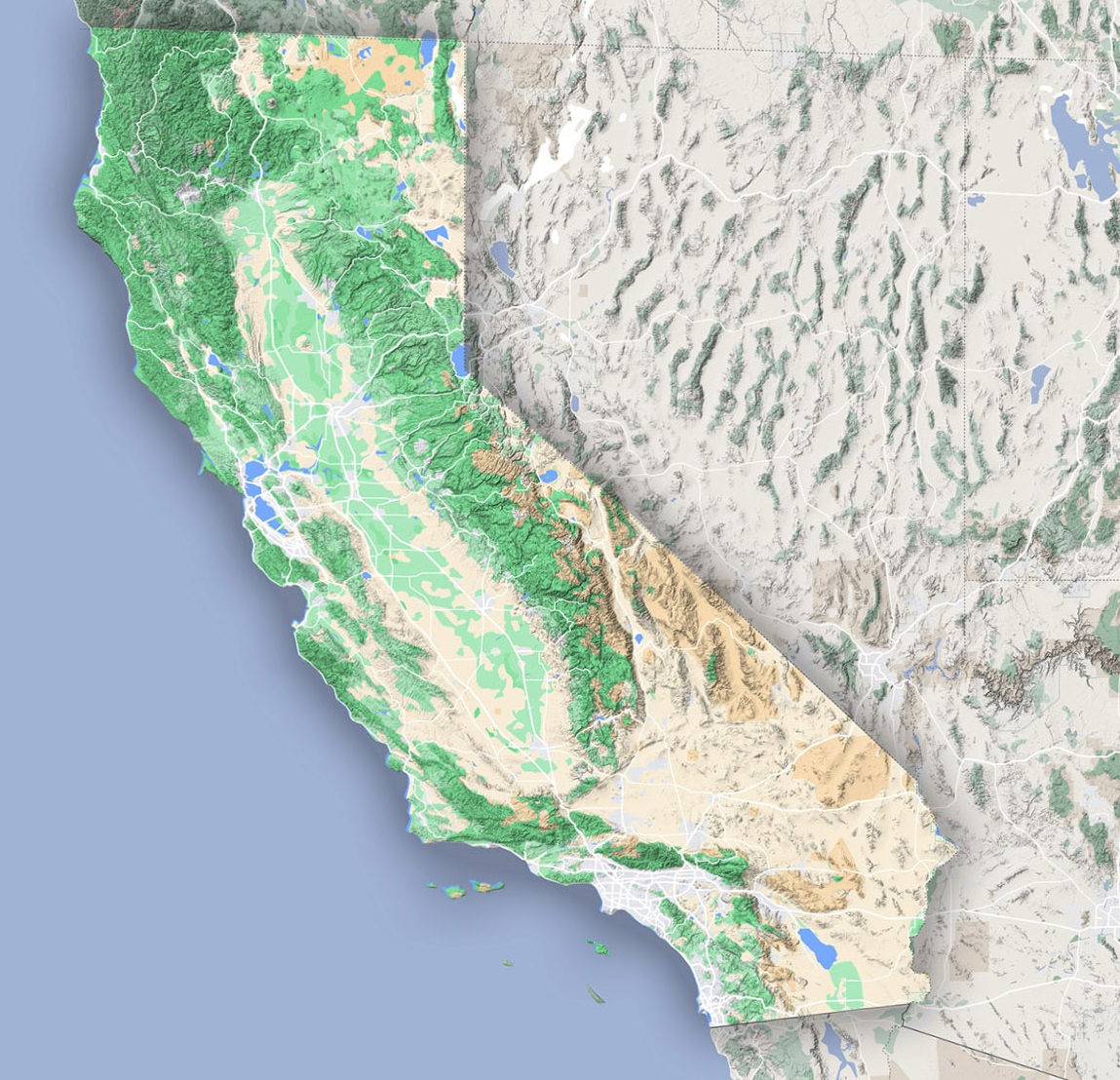
Coastal Regions:
At the very edge of California, the vastness of the Pacific Ocean caresses its western boundary. Stretching for over 800 awe-inspiring miles, the state’s coastline is a study in contrasts. At times, it’s an endless canvas of soft sandy beaches, perfect for sunbathers and surfers alike. Yet, in regions like Big Sur, the coast transforms dramatically. Here, the Santa Lucia Mountains make a bold ascent straight out of the ocean’s depths, creating breathtaking cliffs. These rugged terrains, combined with the incessant beat of ocean waves, are products of eons of tectonic interplay and erosive forces. The beauty of these coastal regions is both serene and volatile, revealing the artistry of nature’s power.
The Central Valley:
Journeying eastward, the vastness of the Central Valley unfurls, a verdant patchwork quilt of farmlands and meadows. Over 450 miles in length, this incredible flatland, guarded by mountain ranges on its flanks, stands as a testament to California’s agricultural prowess. Referred to as the “food basket of the world,” the valley’s abundant produce can be credited to its rich soils – a legacy left behind by ancient rivers that once meandered here. Every inch of this fertile land whispers tales of old waterways, making it a luscious and living archive of geological history.
Sierra Nevada Mountains:
Pressing further east, the horizon begins to rise, giving way to the grandeur of the Sierra Nevada Mountains. These majestic peaks, however, are not just a scenic backdrop. They’re relics of the Earth’s dynamic crust, carved and elevated by the relentless collision and movement of tectonic plates. Nestled among these giants is Mount Whitney, an imposing sentinel that boasts the title of the tallest peak in the contiguous U.S. But the Sierras aren’t just about towering heights; they also cradle gems like the crystal-clear Lake Tahoe and the awe-inspiring granite cliffs of Yosemite Valley.
The Mojave and Colorado Deserts:
Beyond the verdant and rugged embrace of the Sierras, the landscapes undergo yet another dramatic transformation. The arid expanses of the Mojave Desert sprawl out, a stark, yet beautiful wilderness punctuated by the iconic Joshua Trees and punctuated by unique geological formations. At its core lies the Joshua Tree National Park, a symbol of resilience and adaptability. As we traverse further, the Colorado Desert unfurls with its unique character. Dominating this space is the Salton Sea, an inland saline lake, surrounded by a palette of terrains painted by the intricate choreography of water, heat, and time.
The Transverse and Peninsular Ranges:
The southern stretch of California offers another topographical twist. Here, contrary to the general north-south orientation of mountain ranges, the east-west aligned Transverse Ranges rise. Key among these are the San Gabriel and Santa Monica Mountains, cradling valleys and acting as nature’s fortresses against urban sprawl. Further down, the Peninsular Ranges form an extended chain of peaks, spines that stretch far, reaching into the realms of Baja California, and bearing witness to eons of geological evolution.
The Cascades and the Modoc Plateau:
Venturing to the northernmost parts, near the border shared with Oregon, the Cascade Range stands proud. These mountains are peppered with volcanic wonders, none more iconic than the regal Mount Shasta, a beacon of volcanic history and activity. Adjacent to these fiery peaks, the Modoc Plateau presents itself. A land formed from ancient lava flows and volcanic eruptions, it’s a high-altitude expanse, presenting yet another facet of California’s diverse terrains.
Embracing the Diversity:
From coast to peak, desert to valley, California’s terrain is a patchwork of ecosystems and histories. Each landscape tells its own tale, shaped by time, nature, and human touch.
Unfolding California’s terrain map is like reading an epic tale penned by nature. As you journey from the shores to the summits, remember that each contour and color holds a story, waiting to be explored. With every step in the Golden State, you’re walking through chapters of geologic history, diverse ecosystems, and captivating beauty.
Check out WhiteClouds’ 3D Maps for more information on terrain maps of California. 2D Canvas Print Terrain Maps of California are also available.
Contact us today to learn more about our 3D services and how we can help you achieve your goals.