
The Remarkable Terrain Map of Arkansas: Exploring the Natural State
Arkansas, affectionately known as the “Natural State,” offers a rich tapestry of terrains that have shaped its history, culture, and natural beauty. From the majestic Ozark Mountains to the fertile delta plains, the state is a geographer’s delight and an adventurer’s dream. This journey through the terrain map of Arkansas will transport you to its varied landscapes, each narrating a unique story.
What is a Terrain Map of Arkansas?
A terrain map, often known as a topographic or physical map, showcases the diverse physical features and landscapes of a particular area, helping readers grasp the region’s elevations, depressions, and contours. When it comes to the Natural State, a terrain map of Arkansas is a visual masterpiece that provides intricate details about its unique geological formations.
At its core, this map showcases the elevations and depressions in Arkansas’s landscape, using contour lines to indicate areas of similar elevation. The closer these lines are, the steeper the terrain, giving adventurers, planners, and geologists a clearer understanding of the state’s topography.
So, why is a terrain map of Arkansas of particular interest? Given the state’s vast geological diversity – from the soaring heights of the Ozark Plateau to the gentle undulations of the Delta – a terrain map becomes a vital tool. It doesn’t just inform; it tells a tale. This map reveals how millennia of geological processes have sculpted Arkansas, creating a tapestry of highlands, valleys, plains, and plateaus. For explorers, this map serves as a guide to navigate the state’s hiking trails, mining areas, or bird-watching spots, offering insights into what to expect in terms of physical challenges or scenic views. For educators and students, it’s a window into the state’s geological history, bringing textbook lessons to life.
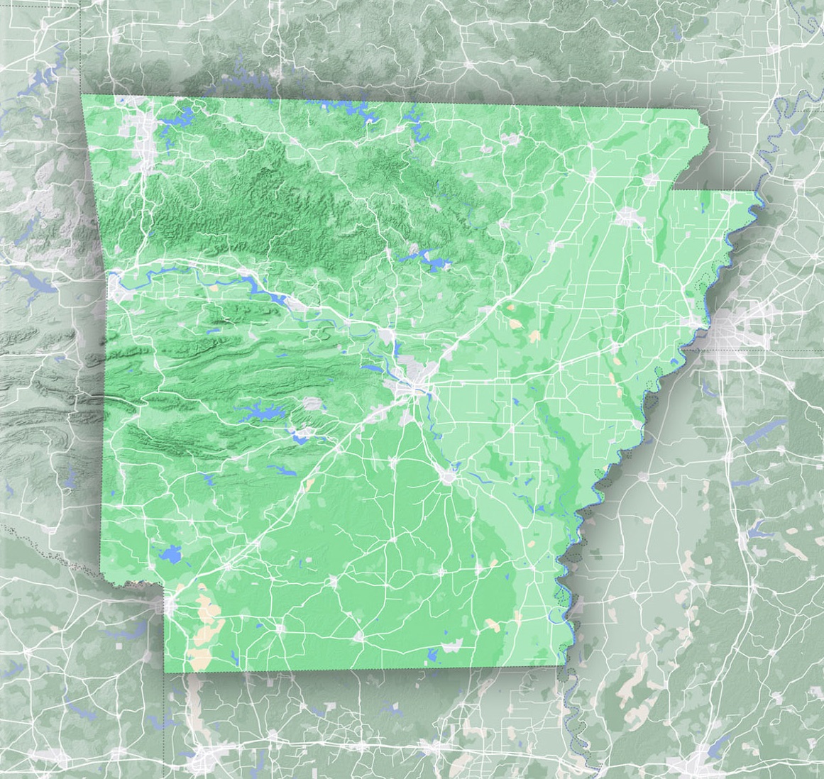
Ozark Plateau: Nature’s Crown Jewel
The Ozarks, or Ozark Plateau, is undoubtedly one of Arkansas’s most iconic terrains. Nestled in the northern and western parts of the state, this region is a symphony of rolling hills, cavernous formations, and sparkling rivers. The karst topography, formed by the dissolution of soluble rocks, has resulted in an extensive underground network of caves, each teeming with its own set of mysteries. The Ozark National Forest spans 1.2 million acres, offering dense hardwood forests, flowing streams, and opportunities for hiking, camping, and nature watching.
The Arkansas Delta: Where Land Meets Water
East of the Ozarks, the Arkansas terrain transitions into the fertile Mississippi Alluvial Plain, commonly referred to as the Delta. Historically shaped by the ebb and flow of the mighty Mississippi and Arkansas rivers, this region boasts some of the richest soil in the state. It’s no surprise that the Delta became a hub for agriculture, especially cotton, rice, and soybeans. Along with its agricultural prowess, the Delta is also home to myriad bird species, making it a birdwatcher’s paradise.
Ouachita Mountains: Ancient Ridges and Verdant Valleys
To the south and west of the state lies the Ouachita Mountain range, distinguished by its east-west orientation, unlike most North American ranges that run north-south. These ancient mountains, formed over 300 million years ago, are adorned with thick forests of pine and hardwoods. Hot Springs National Park, embedded in the Ouachita region, is a testament to the region’s geothermal activity, inviting visitors to bask in its therapeutic waters.
Gulf Coastal Plain: A Mosaic of Forests and Wetlands
As one moves further south, the terrain gently descends into the Gulf Coastal Plain. This low-lying area is characterized by pine forests, swamps, and a smattering of lakes. The region is notably rich in minerals, leading to a long history of diamond and quartz mining. Crater of Diamonds State Park allows visitors to channel their inner gem hunter and search for diamonds in its 37-acre field.
Crowley’s Ridge: A Geological Anomaly
One of the most intriguing features on the Arkansas terrain map is Crowley’s Ridge, a crescent-shaped formation that stretches from southeastern Missouri down into Arkansas. This unique landform rises conspicuously from the Delta, with elevations reaching up to 500 feet. Its loamy soil, a stark contrast to the surrounding Delta, supports a lush landscape of hardwood forests, flora, and fauna. The ridge, with its pleasant hiking trails, provides a panoramic view of the Delta’s expanse.
Arkansas River Valley: Where Fertile Meets Rugged
The Arkansas River cuts through the state, creating the Arkansas River Valley, which lies sandwiched between the Ozarks and the Ouachita Mountains. This region offers a diverse mix of rugged hills and fertile plains, embodying the dynamic interplay between the river’s meandering journey and the surrounding terrains. Lake Dardanelle, situated in this valley, offers a picturesque setting for fishing, boating, and camping.
Embracing the Diversity of the Natural State
Arkansas’s diverse terrain is a reflection of its rich geological history, shaped over millions of years by tectonic shifts, water courses, and erosional processes. Each region, with its distinct topographical features, contributes to the state’s ecological, cultural, and economic tapestry.
Whether you’re an avid hiker eager to traverse the trails of the Ozarks, a bird enthusiast keen to explore the Delta’s wetlands, or a geology aficionado ready to delve into the mysteries of the Ouachitas, Arkansas promises an immersive experience. So, the next time you’re looking at a terrain map of Arkansas, remember that it’s not just about contours and elevations; it’s a gateway to countless adventures waiting to be embarked upon in the Natural State.
Check out WhiteClouds’ 3D Maps for more information on terrain maps of Arkansas. 2D Canvas Print Terrain Maps of Arkansas are also available.
Contact us today to learn more about our 3D services and how we can help you achieve your goals.