
Unveiling Wyoming from the Heavens: The Satellite’s Perspective
Imagine gazing upon Earth from miles above, where state borders blur and landscapes take center stage. Through the technological marvel of satellite mapping, we’re offered a fresh perspective on familiar terrains. Today, let’s zoom in on a state known for its vast plains, majestic mountains, and iconic landmarks: Wyoming.
Satellite Mapping: A Brief Overview
Satellite mapping involves capturing high-resolution images of Earth using satellites. These images, when processed and pieced together, present a comprehensive view of large landscapes and minute details alike. This bird’s-eye perspective not only serves geographers and scientists but also provides a unique vantage point for nature enthusiasts and the general public.
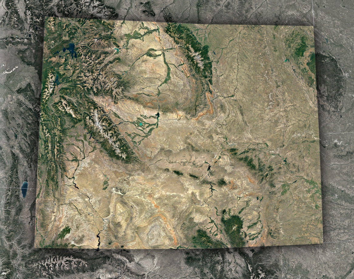
Wyoming’s Geographic Tapestry: A Satellite’s Perspective
While Wyoming stands proud as the 10th largest state in the U.S., its vastness is just the beginning of its allure. More than just its size, it’s the state’s multifaceted landscapes, from towering mountains to vast prairies, that truly captivate, especially when seen from a bird’s-eye view.
The Majesty of the Rocky Mountain Ranges: The western part of Wyoming is a testament to the grandeur of nature, primarily dominated by the imposing Rocky Mountains. Through satellite imagery, the distinct features of several mountain ranges become evident, providing a deeper appreciation for their geological significance. Among these are the majestic Wind River Range, the rugged Big Horn Mountains, and the iconic Tetons. Each of these ranges, with their soaring, snow-clad peaks and deep, craggy valleys, paints a picture of raw, natural beauty. The intricacy of their terrain stands in vivid contrast to the flatter landscapes that lie further east.
A Sea of High Plains and Rolling Prairies: Journeying eastward, the mountains begin to recede, giving way to the expansive High Plains that cover nearly two-thirds of Wyoming. This vast region is a sea of undulating grasslands, gently rolling hills, and open skies. When viewed from above, this part of Wyoming unfurls like a vast canvas, marked by a myriad of green hues, each patch representing different vegetation and terrain. Rivers meander through, nourishing the land, while towns, both big and small, dot the landscape, showcasing human settlement amidst nature’s grandeur.
Wyoming’s Water Wonders: No overview of Wyoming would be complete without acknowledging its rich hydrological features. Water plays a pivotal role in shaping and nourishing the state’s varied landscapes. Through the lens of a satellite, one can trace the sinuous path of the Snake River, meandering and carving its way through the land. Similarly, the vastness of Yellowstone Lake emerges as a shimmering jewel amidst the wilderness. In addition to these, numerous reservoirs are scattered throughout the state, each serving as a vital water source and a hub of biodiversity, making Wyoming a land where water’s life-giving properties are celebrated and revered.
Spotlight on Iconic Landmarks
Satellite mapping doesn’t just offer a top-down view of landscapes; it provides a fresh perspective on some of Wyoming’s most iconic landmarks:
- Yellowstone National Park: This iconic park is easily discernible from space. The Grand Prismatic Spring, with its vibrant hues, stands out, as does the Old Faithful geyser area. The contrasting landscapes of Yellowstone, from its geothermal areas to dense forests and deep canyons, are a treat for the eyes.
- Grand Teton National Park: The jagged peaks of the Teton Range are unmistakable. The satellite view emphasizes the contrast between the park’s alpine terrains and the flat Jackson Hole valley.
- Devils Tower: This geologic wonder, protruding from the plains, casts a significant shadow, emphasizing its unique structure and importance to Native American tribes.
The Profound Impact of Satellite Perspectives
Satellite views of Wyoming aren’t just visually striking; they offer numerous practical insights:
-
Environmental Monitoring: Satellites help monitor deforestation, river path changes, and climate change impacts, vital for a state with diverse ecosystems like Wyoming.
-
Urban Development Tracking: Cities like Cheyenne and Casper can be studied for urban sprawl, infrastructure development, and growth patterns.
-
Historical and Cultural Insights: Ancient indigenous sites, trails, and historic landmarks become more contextual when viewed in relation to the larger landscape.
A Virtual Tour for All
With the advancements in technology, everyone can embark on a virtual journey over Wyoming using various online platforms. These satellite map services let users zoom into their favorite spots, traverse vast landscapes, and gain a broader appreciation for the state’s geography.
Wyoming, often celebrated for its untamed beauty and rich history, becomes an even more captivating subject when viewed from the cosmos. Satellite maps don’t just present a visual spectacle; they weave a story of nature, history, and human intervention. As we wrap up this aerial exploration, one thing becomes clear: there’s always more to discover when we change our vantage point and look at the world from above.
Check out WhiteClouds’ 3D Maps for more information on satellite maps of Wyoming. 2D Canvas Print Satellite Maps of Wyoming are also available.
Contact us today to learn more about our 3D services and how we can help you achieve your goals.