
Wisconsin From Above: A Satellite Symphony of Lakes and Lands
Wisconsin, America’s Dairyland, is often lauded for its cheese, Badgers, and Packers. But beyond its renowned sports and dairy delights, it’s a state that boasts a captivating array of landscapes. Through the lens of satellite technology, Wisconsin emerges as a stunning tapestry of lakes, forests, cities, and farmland. Journey with us as we embark on a celestial exploration of this Midwestern marvel.
The Prologue: Orbiting Observers
Orbiting hundreds of miles above, satellites provide unparalleled perspectives. In Wisconsin’s context, these advanced instruments uncover a multifaceted state where the interplay of human and natural elements weave a complex, beautiful narrative.
Wisconsin from Above: A Satellite’s Exploration of Nature and Design
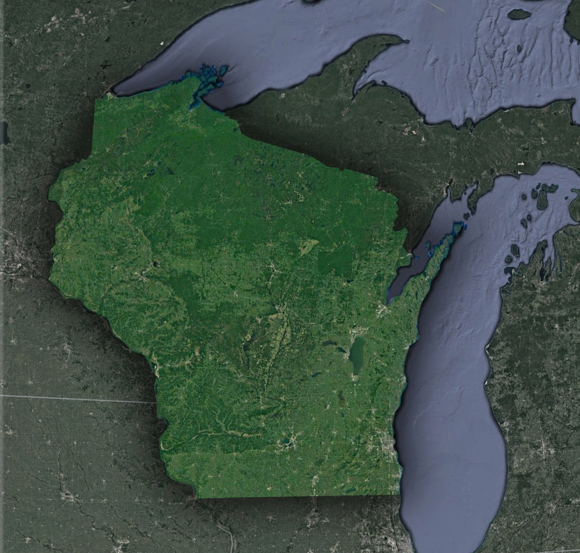
Lake Superior & Lake Michigan-Nature’s Majestic Mirrors: Nestled along Wisconsin’s northern and eastern frontiers, the Great Lakes of Superior and Michigan stand as resplendent liquid marvels. As satellites soar above, they capture not just the breathtaking vastness of these freshwater seas but also the intricate details of their coastlines. The captivating Apostle Islands in Lake Superior beckon with their rugged charm, while Door County’s slender peninsula in Lake Michigan juts out, reminiscent of a hand reaching into the waters.
The Driftless Area-Time’s Untouched Canvas: This unique southwestern region of Wisconsin is a geographical wonder, having escaped the icy grasp of the last glaciers from the Ice Age. From the heavens, it presents itself as a multilayered canvas, with a mosaic of ridges kissing the clouds, deep valleys cradling ancient secrets, and elevated plateaus standing as silent sentinels. This landscape stands in stark contrast to the surrounding flatter expanses, narrating tales of geology and time.
Urban Hubs and Networks-Confirmation of Human Endeavors: Amidst Wisconsin’s natural splendors, the urban sprawls of Milwaukee, Madison, Green Bay, and other vibrant cities emerge as living confirmation of human ambition and progress. From the satellite’s perspective, these areas unfold as mesmerizing patterns, showcasing the intricate dance between human innovation and nature. They are a blend of architectural marvels, expansive parks, and winding roads, painting a picture of dynamic growth.
The Central Plains-The Breadbasket’s Grand Display: The heart of Wisconsin is a vast checkerboard of fertile lands, each square reflecting a part of the state’s agricultural heritage. Satellite views offer a unique perspective on this region, from the ruby-hued cranberry bogs that seem to sparkle from space to the expansive dairy farms that underscore Wisconsin’s title as America’s Dairyland. This agrarian patchwork stands as a proud testament to generations of farmers and their bond with the land.
The Northwoods-A Symphony of Wilderness: The northern realms of Wisconsin are a verdant embrace of nature in its rawest form. This sprawling territory, dotted with dense forests, serene lakes, and meandering rivers, offers a sanctuary for countless species. Each body of water, whether a tranquil lake reflecting the azure sky or a river forging its path, narrates a unique story of nature’s grandeur and resilience.
Satellites at Work: Beyond Mere Imagery
- Water Quality Monitoring in the Lakes: With over 15,000 lakes, maintaining water quality is vital. Satellites assist in monitoring algal blooms, especially in bodies like Lake Winnebago.
- Forest Management and Conservation: The Chequamegon-Nicolet National Forest and other woodlands benefit from satellite surveillance, ensuring sustainable logging and detecting forest fires.
- Agricultural Yield Predictions: Satellites assist farmers by predicting crop yields, analyzing soil health, and guiding irrigation needs.
- Urban Development and Planning: The rapid expansion of cities like Eau Claire or La Crosse can be planned sustainably with insights from satellite imagery.
Wisconsin’s Tomorrow: Satellite’s Role
- Climate Change Impact: From changing precipitation patterns to shifts in agricultural zones, satellites will be instrumental in helping Wisconsin navigate climate-induced challenges.
- Biodiversity Monitoring: With rich habitats, from wetlands to forests, satellites will aid in tracking animal migrations and ensuring biodiversity conservation.
- Renewable Energy Mapping: As Wisconsin increasingly embraces renewables, satellites can guide the optimal placement of solar panels and wind turbines.
Epilogue: Wisconsin’s Ethereal Ballet
Wisconsin, when viewed from the ground, is a land of endless wonder. But when observed from the heavens, it becomes pure magic. Each snow-covered ridge, each autumnal forest, and each city aglow at night is a part of this grand performance.
As you paddle down the Wisconsin River, explore the bustling streets of Milwaukee, or sip on fresh apple cider in a Door County orchard, remember the bigger picture. Satellites are forever serenading Wisconsin, capturing not just images but the very essence of a state that is as diverse as it is beautiful. Through their cosmic lens, Wisconsin isn’t merely geography; it’s an ode to Earth’s splendor.
Check out WhiteClouds’ 3D Maps for more information on satellite maps of Wisconsin. 2D Canvas Print Satellite Maps of Wisconsin are also available.
Contact us today to learn more about our 3D services and how we can help you achieve your goals.