
The Evergreen from Above: A Celestial Dive into Washington State
The Pacific Northwest has always been a region cloaked in mystique, where emerald forests meet rugged coastlines and towering peaks touch the heavens. Washington, a jewel of the northwest, sparkles with unparalleled beauty. But what revelations await when we soar above and glimpse this land from the celestial realms? Join our orbital journey over Washington State and be prepared for an elevated enchantment!
Orbiting with Purpose
The quiet hum of satellites, traversing the great cosmic void, presents an avenue to explore our world in ways previously unfathomable. These modern marvels capture and narrate Earth’s tales with every snapshot. As we cast our satellite-focused eyes on Washington, prepare for a symphony of natural wonders and bustling urban landscapes.
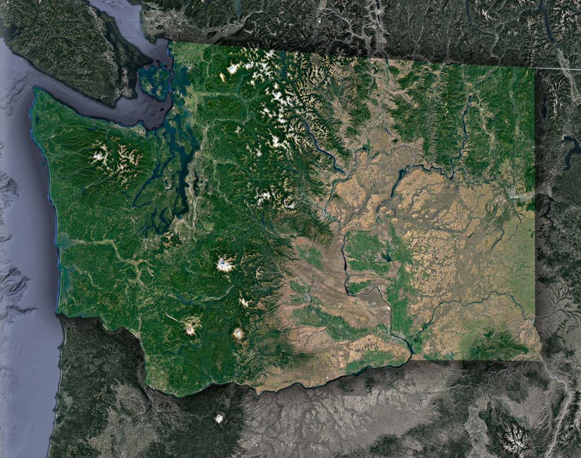
The Washington Mosaic: Satellite’s Panorama
Puget Sound’s Enchanting Azure Hug: The vast Puget Sound, with its intricate dance of inlets, bays, and islands, offers an unparalleled marine panorama, akin to an artist’s masterpiece. As the waters twist and turn, they cradle cities such as Seattle and Tacoma. From a satellite’s perspective, these urban hubs emerge as bustling networks, their dense configurations creating a striking juxtaposition against the serene deep blue of the water.
The Grandeur of the Cascade Range: Prominent amongst Washington’s geologic wonders, peaks like Mount Rainier and Mount St. Helens rise with regal poise. These colossal mountains, along with their sibling summits, reach ambitiously for the heavens. When viewed through the discerning eye of our satellite technology, these frosty pinnacles seem to stand out even more vividly, providing a breathtaking counterpoint to the lush green terrains that cushion their bases.
The Hypnotic Waves of the Palouse: Venturing further to the east, one encounters the rhythmic undulations of the Palouse hills. These are not mere hills; they are nature’s own canvas, ever-changing with the seasons. As crops grow, mature, and are harvested, they impart a multitude of hues to these hills, rendering them a living art piece that alters its shades with time’s passage.
San Juan Islands-Nature’s Dappled Masterpiece: Nestled within the embracing arms of Puget Sound lies the San Juan archipelago, a testament to nature’s splendor. This collection of islands, each with its own character, boasts a fusion of dense forests and pristine shorelines. Observing them from the heavens, they glitter like emerald gems sewn onto a vast sapphire tapestry, captivating the beholder with their raw, untouched allure.
Eastward Explorations-Vines and Varied Terrains: Journeying further east introduces a shift in Washington’s diverse topography. The vineyards surrounding the Walla Walla region stand proud, their meticulously aligned vines presenting a sight of organized beauty, almost reminiscent of nature’s own patchwork quilt. Beyond these vineyards, the landscape undergoes another transformation near the Columbia River. Here, the rich blues of the river playfully intertwine with the arid desert terrains, creating a harmonious blend of contrasts – a testament to the state’s varied and enchanting landscapes.
Satellite Insight: Washington’s Evolving Narrative
Satellites do more than just paint pretty pictures:
- Monitoring Ecosystem Health: Washington’s diverse habitats, from the Hoh Rainforest to the sagebrush plains, can be assessed for health, invasive species, and climate change impacts using satellite data.
- Urban Expansion and Sustainable Growth: Cities like Spokane and Bellevue undergo change, and with time-lapse satellite imagery, urban planners can ensure growth without compromising green spaces.
- Tracking Glacial Melt: The glaciers adorning the Cascades are crucial water sources and temperature indicators. Satellites aid in monitoring their status and predicting future water availability.
- Forest Conservation Efforts: With dense forests forming Washington’s green mantle, satellites play an instrumental role in tracking deforestation, potential logging activities, and forest fires.
Washington’s Future: Satellite’s Unceasing Vigil
Advancements loom on the horizon:
- Climate Impact Studies: Tracking seasonal shifts, rainfall patterns, and temperature anomalies to predict and manage the effects of climate change.
- Marine Health: Monitoring Puget Sound for algal blooms, pollution, and marine life patterns to ensure its continued vibrancy.
Washington’s Celestial Ballet: Reflections from Above
Hovering over Washington State, satellites capture more than just terrain; they encapsulate the essence of a region steeped in natural wonders and cultural riches. From the bustling Pike Place Market in Seattle to the serene moments at Deception Pass, every nuance is a part of the grand narrative.
When you next hike the Olympic Peninsula’s trails, sail on Puget Sound, or marvel at the Cascades’ grandeur, remember: high above, satellites dance their cosmic waltz, chronicling Washington’s every heartbeat. Through this elevated gaze, Washington State emerges not merely as land and water, but as a pulsating ode to Earth’s magnificence.
Check out WhiteClouds’ 3D Maps for more information on satellite maps of Washington State. 2D Canvas Print Satellite Maps of Washington State are also available.
Contact us today to learn more about our 3D services and how we can help you achieve your goals.