
Utah from the Universe: The Satellite’s Tale of the Beehive State
Nestled in the American West, Utah is a state of contrasts. From its iconic red rock formations to the bustling urban life in Salt Lake City, Utah’s diversity is unparalleled. But how does this land of deserts, mountains, and lakes look from above? Thanks to satellite technology, we can journey across Utah from a celestial perspective. Join us on this astral adventure!
The Power of Satellite Glimpses
Satellite imagery is a spectacular blend of technology and art. It allows us to soar above, offering views that meld topographical accuracy with sheer aesthetic beauty. As we venture into Utah, we are treated to a canvas of colors, patterns, and tales of geological wonders.
Utah’s Varied Vistas: A Satellite Tour
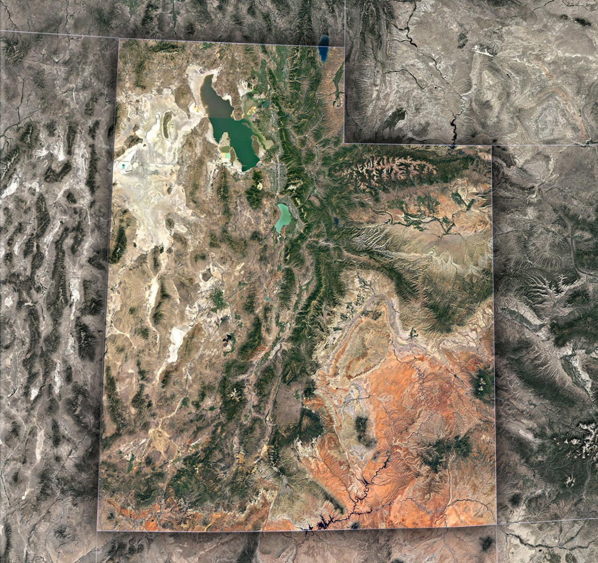
The Red Rock Resplendence: Utah’s southern regions, especially around Moab, are renowned for their red rock formations. The Arches National Park, with its famous Delicate Arch, appears from space as a mesmerizing maze of rust-red loops and contours. Nearby, Canyonlands National Park showcases a complex network of canyons carved by the Colorado River.
Salt Lake City – Urban Oasis Amidst the Mountains: The state’s capital offers a stark contrast to the wild landscapes of southern Utah. Framed by the Wasatch Range, Salt Lake City’s geometric grids, and the vast expanse of the Great Salt Lake, stand out clearly in satellite views. The lake’s fluctuating water levels and salinity create unique color variations, making it a visual treat from above.
The Alpine Allure of the Wasatch: The Wasatch Mountain Range, especially around areas like Park City, is a dense tapestry of peaks and valleys. In winter, satellite images might capture the snowy sheen of ski resorts, while summers showcase the verdant vibrancy of alpine meadows.
Enigma of the Bonneville Salt Flats: West of the Great Salt Lake, the Bonneville Salt Flats look like a white canvas from space. This vast expanse, a remnant of ancient Lake Bonneville, is surreal in its uniformity, often used for land speed records due to its flatness.
The High Plateaus and Forested Terrains: Beyond the red rock deserts lie the high plateaus of central Utah, covered in forests and punctuated by places like Bryce Canyon National Park. From a satellite’s view, Bryce appears as an amphitheater of hoodoos—spire-shaped rock formations—that play with shadows and light.
Satellite Imagery’s Practical Impacts in Utah
Beyond their beauty, satellite views offer practical applications:
Natural Resource Management: Utah, rich in minerals, uses satellite imagery to manage mining activities, ensuring they don’t adversely affect the environment.
Urban Development: Places like Provo and Ogden benefit from satellite data to optimize urban planning, infrastructure development, and green space preservation.
Environmental Conservation: Satellite images track changes in national parks and forests, guiding conservation efforts and wildlife management.
Water Resource Monitoring: With Utah’s semi-arid climate, efficient water management is crucial. Satellites help monitor reservoir levels, river flows, and potential drought areas.
Forward Focus: Emerging Satellite Innovations
In the ever-evolving world of satellite tech, future prospects include:
Improved Climate Studies: Utah’s diverse climate can be better understood through detailed satellite imagery, assisting in predicting weather anomalies or shifts in precipitation patterns.
Biodiversity Mapping: Areas like the Uinta-Wasatch-Cache National Forest can benefit from regular satellite surveillance, aiding in wildlife conservation and habitat restoration.
Utah’s Cosmic Canvas
Utah, a state steeped in history, nature, and modernity, unveils its intricate tapestry beautifully when viewed from space. Each satellite image captures a moment in time—whether it’s the snowy embrace of the Wasatch or the sun setting over the red rocks, painting them deeper shades of crimson.
As you hike through Zion, ski in Park City, or attend a conference in Salt Lake City, remember that high above, satellites are tracing your journey, stitching it into the grand narrative of the Beehive State’s ever-evolving story.
Check out WhiteClouds’ 3D Maps for more information on satellite maps of Utah. 2D Canvas Print Satellite Maps of Utah are also available.
Contact us today to learn more about our 3D services and how we can help you achieve your goals.