
Texas from Above: Satellite Reveals the Lone Star State’s Majesty
Ah, Texas! The Lone Star State, renowned for its vast landscapes, dynamic cities, and rich history, always captivates. But have you ever viewed Texas from above? Not from an airplane, but from much, much higher. Thanks to the power of satellite imaging, we can now explore the entire stretch of Texas from the vantage point of space. Let’s embark on this exhilarating journey together!
A New Frontier: The Wonders of Satellite Imagery
Satellite imagery has ushered us into a golden era of geographical exploration. Instead of artistic approximations or mere sketches, satellite maps offer high-resolution, real-time snapshots of our planet. With platforms like Google Earth and NASA’s Worldview, even the minutiae of the Earth’s surface come to life in breathtaking detail.
Texas in Satellite Focus: Landmark Highlights
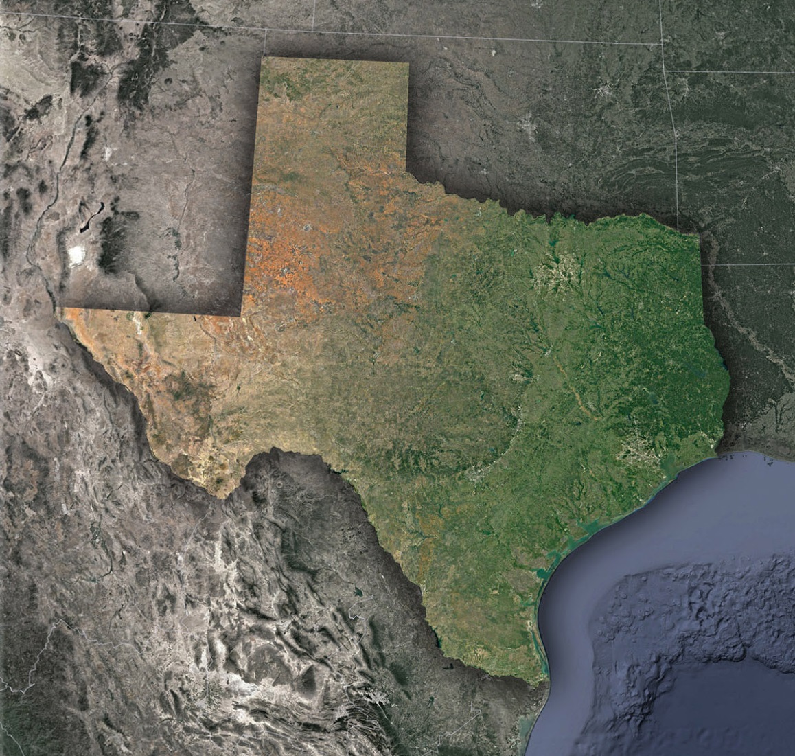
Lone Star Landscapes: Deserts to Piney Woods: Starting west, the satellite reveals the arid beauty of the Chihuahuan Desert, with its varied tones of browns and reds. Traveling eastward, the terrain shifts dramatically, from the rugged Hill Country to the lush Piney Woods and the Gulf Coast marshlands. This spectrum of landscapes underscores Texas’s vastness and diversity.
Houston: A Space City Snapshot: Fittingly termed the “Space City” due to its NASA connection, Houston’s sprawling urban expanse stands out remarkably from space. Satellite imagery captures the intricate network of roads, the port’s busy waterways, and the city’s proximity to the Gulf Coast.
Dallas-Fort Worth: Urban Duo: The combined metroplex of Dallas and Fort Worth forms a distinct urban patch, with satellite images highlighting their interconnectedness, sprawling suburbs, and key landmarks, like the DFW International Airport, one of the world’s largest.
The Panhandle and Great Plains: Texas’s Panhandle stands out prominently. Here, satellite imagery reveals the grid-like pattern of agricultural lands, a testament to the region’s farming significance.
The Mesmerizing Big Bend: Bordering Mexico, the Big Bend National Park is a treasure trove of canyons, deserts, and the winding Rio Grande. Its rugged beauty is amplified from space, emphasizing the region’s topographical richness.
The Practical Magic of Satellite Imaging in Texas
Beyond marveling at the state’s grandeur, satellite imaging provides tangible benefits:
Resource Management: Texas’s vast oil fields, especially in the Permian Basin, are closely monitored using satellite data, aiding efficient resource extraction.
Agricultural Insights: Texas, a major agricultural state, benefits as farmers utilize satellite images for precision agriculture, monitoring crop health and irrigation needs.
Disaster Management: In a state that occasionally contends with hurricanes and floods, real-time satellite imagery is crucial for early warnings and subsequent relief operations.
Environmental Monitoring: Texas’s varied ecosystems, from coastal marshes to inland deserts, can be studied and conserved better with the data satellites provide.
Peeking into the Future: Satellite Tech and Texas
The evolution of satellite technology is relentless. With advancements like hyper-spectral imaging and AI integration, we might soon get even clearer, multi-dimensional views of Texas.
Such advancements can offer myriad insights, from tracking urban sprawl in cities like Austin to monitoring the health of coral reefs off the Texas coast. As satellite data becomes more accessible, we can expect Texan students, researchers, and enthusiasts to contribute significantly to local and global knowledge pools.
Embracing the Celestial Overview
Texas, with its iconic motto “Everything’s Bigger in Texas,” truly embodies grandness. This grandeur, when viewed from space, gains a new dimension of awe. Through satellite imagery, we don’t just see Texas; we perceive its essence, its vast stretches of untouched lands, its bustling cities, and its intricate tapestry of life.
So the next time you’re driving through the Texan highways or relishing a sunset over the Gulf, remember: there’s a view from the cosmos, capturing that moment, linking the vastness of space to the heart of Texas. In this dance of technology and nature, the Lone Star State shines even brighter.
Check out WhiteClouds’ 3D Maps for more information on satellite maps of Texas. 2D Canvas Print Satellite Maps of Texas are also available.
Contact us today to learn more about our 3D services and how we can help you achieve your goals.