
Exploring the Satellite Map of Oregon: A Journey from Above
Oregon, with its myriad landscapes ranging from mist-kissed coastlines to sun-baked deserts, offers a unique spectacle when viewed from space. Satellite maps present this Pacific Northwest gem in an entirely different light, making visible not only its captivating beauty but also the intricate tales embedded within its geology and human history.
A Panoramic Overview
The Mesmerizing Pacific Coastline: Begin your skyward journey by casting your gaze over the magnificent western boundary of Oregon. The coastline is an ever-evolving tapestry stretching over 360 miles. It’s an intricate dance of nature where soft sandy stretches warmly embrace the ocean’s waves, while jagged cliffs rise defiantly, as if challenging the relentless power of the Pacific. From the sweeping dunes to the rocky promontories, the coastline, when seen from above, paints a picture of eons of interaction between land and sea. The estuaries, looking like the fingers of the land reaching into the ocean, and the river mouths, weaving their way to meet the vast Pacific, punctuate this stretch, making it an ever-changing landscape of blues and greens.
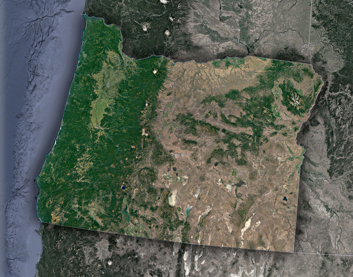
The Verdant Forest Reserves: Moving a bit inland, the sprawling Tillamook and Siuslaw National Forests beckon. These vast wooded territories are a testimony to the Pacific Northwest’s rich biodiversity. The forests, a dense green expanse, look like a plush emerald quilt draped over the land. Each tree, when looked at collectively, contributes to a hue that seems to shimmer with life. Here, ancient trees have stood the test of time, and their combined presence forms a massive sea of green that looks almost velvety from the cosmos.
Cascade Range-Nature’s Majestic Monument: As your satellite-guided journey continues eastward, the topographical drama of Oregon takes a vertical turn. The Cascade Range, an imposing series of mountains, stretches out like a spine of the state. These aren’t just mountains; they’re silent storytellers. Each peak, from the iconic Mt. Hood to the lesser-known but equally majestic mounts, speaks of the Earth’s deep volcanic activities and geological transformations. The snow-kissed summits glitter like jewels under the sun, offering a stark and breathtaking contrast to the forests blanketing their lower slopes.
Beyond the Mountains-The Desert’s Whisper: As the cascading peaks slowly recede, another vast and mesmerizing landscape unveils – the high desert of Oregon. It’s a realm that seems to belong to another world, especially after the lushness of the preceding terrains. The desert stretches endlessly, its vastness marked by hues of gold, amber, and beige. Sand, scrub, and sparse vegetation create a mosaic of patterns, a testament to the adaptability of life in harsh conditions. The play of shadows and light over this terrain, especially during the golden hours, turns the landscape into a canvas of artistry that’s both subtle and profound.
Human Imprints on a Natural Canvas
Oregon’s satellite imagery is not just a testament to nature’s artistry but also to human innovation and adaptability.
- Infrastructure Wonders: The Interstate 5 corridor, a vital north-south conduit, appears like a meticulously drawn line. Cities, from bustling Portland to the artsy hubs of Eugene and Ashland, emerge as grey and beige patches, surrounded by a network of roads, like veins supplying life to the heart.
- Agricultural Innovations: The Willamette Valley, known for its fertile soils, is a patchwork of varied hues. Here, technology-driven agriculture coexists with traditional methods. The diverse shades of green and gold hint at the crops below – from vineyards producing world-class wines to fields of hops, blueberries, and more.
Historical Layers: The Stories Beneath
Using satellite maps as a guide, delving deeper into Oregon’s history reveals how the state has been shaped by both natural events and human endeavors.
- Missoula Floods’ Legacy: The unique land formations and sediment deposits in the Willamette Valley, visible even from space, recount the saga of the Missoula Floods. These catastrophic events, which occurred millennia ago, left behind a landscape that became a boon for agriculture and human habitation.
- The Timber Industry’s Mark: Another indelible mark on Oregon’s landscape is its logging history. Large clear-cut patches, especially in the western regions, indicate this industry’s magnitude and impact. But, interspersed between these are protected lands – areas where nature has been allowed to reclaim its space, signifying Oregon’s evolving relationship with its forests.
High-Tech Tools and Exploration
Satellite imagery of Oregon is more than just a visual treat. Modern tools let us peel back layers, revealing intricate details.
- GIS and Data Overlays: Integrating Geographic Information Systems (GIS) with satellite maps has revolutionized our understanding. With data overlays, we can discern patterns in everything from animal migration routes to urban development trends.
- 3D Visualizations: The flat imagery comes alive with 3D visualization tools. Imagine virtually soaring over the sand dunes of the Oregon coast, or navigating the dense forests, all from the comfort of your screen!
Wrapping Up the Journey
The satellite map of Oregon is a rich tapestry of stories, both ancient and modern. Each pixel can unfurl a tale, be it of nature’s might, human tenacity, or the symbiotic relationship between the two. As we continue to advance technologically, our ability to delve deeper and appreciate the nuances of this aerial view will only magnify. Through the lens of satellite imagery, Oregon, with its undulating landscapes and layered history, truly becomes a dynamic storybook, waiting for each of us to turn its pages.
Check out WhiteClouds’ 3D Maps for more information on satellite maps of Oregon. 2D Canvas Print Satellite Maps of Oregon are also available.
Contact us today to learn more about our 3D services and how we can help you achieve your goals.