
Oklahoma from Orbit: Satellite Insights into the Sooner State
Oklahoma, where the wind comes sweeping down the plain, has captured the imagination of many through song, history, and its unique position as the crossroads of America. But have you ever seen this diverse land from a bird’s eye view, or rather, a satellite’s gaze? Come with us on a stellar journey as we explore Oklahoma from space, revealing its fascinating tapestry of landscapes.
Introduction: A Glimpse of Satellite Technology
Satellite imagery is like magic to the curious mind, offering views that were once reserved for celestial beings. These high-resolution images, captured by advanced technology in space, provide profound insights into our world’s natural wonders, urban development, and climatic phenomena.
Unraveling Oklahoma’s Beauty from Above
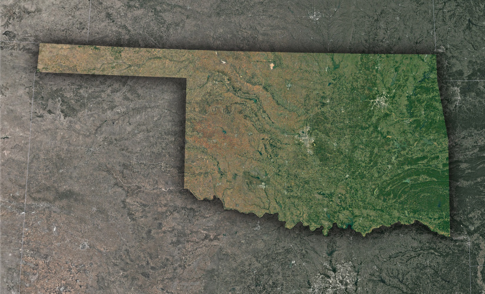
The Glistening Great Plains: Oklahoma’s predominant feature, the Great Plains, stretches majestically across the satellite’s view. These plains, which are interrupted occasionally by hills, mesas, and low mountain ranges, appear like vast quilts of green and gold, depending on the season.
Dynamic Oklahoma City: The state’s capital and largest city stands out prominently. Oklahoma City’s urban sprawl, with its grid-like pattern, contrasts starkly with the natural landscapes surrounding it. Highlights include the serpentine flow of the Oklahoma River and the vibrant Boathouse District.
The Arcane Arbuckles: Toward the south-central part of the state, the Arbuckle Mountains showcase ancient rock formations, steeped in geological history. Their intricate patterns, with lakes nestled among them, become evident from space, revealing a region rich in biodiversity.
Intriguing Water Bodies: Oklahoma, often surprisingly to many, is a state with numerous lakes and reservoirs. Grand Lake O’ the Cherokees, Eufaula Lake, and Texoma Lake shimmer distinctly in the satellite view, offering a hint of the recreational activities they host.
The Red River Ribbon: The southern boundary of Oklahoma is defined by the Red River, which shines as a reddish-brown ribbon in satellite images, owing to its unique sediment content. Its winding path offers an enchanting sight from above.
The Practical Perspectives: Satellite Imagery in Action
Satellite views do more than just cater to aesthetic pleasures; they play pivotal roles in:
Agriculture: Oklahoma’s agrarian economy, especially wheat farming, benefits from satellite insights. These images help monitor crop health, soil moisture, and optimize irrigation practices.
Water Management: With several lakes and rivers, Oklahoma requires efficient water management. Satellite data aids in gauging water levels, ensuring adequate supplies during drier periods.
Urban Planning: For cities like Tulsa, satellite imagery assists urban developers in balancing expansion while preserving green belts and watersheds.
Natural Disaster Monitoring: Oklahoma’s susceptibility to tornadoes and wildfires means that real-time satellite views can be lifesavers, offering early warnings and damage assessments.
Into the Future: Satellites & Oklahoma’s Prospects
Emerging satellite technologies promise more in-depth, real-time insights:
Climate Studies: With changing global climates, satellites can monitor Oklahoma’s temperature, precipitation patterns, and drought conditions, aiding farmers and policymakers.
Biodiversity Conservation: The Wichita Mountains Wildlife Refuge and other natural habitats can be observed for animal migrations and changes in vegetation, guiding conservation efforts.
Oklahoma’s Starry Rhapsody
Oklahoma’s allure lies in its contrasts—where plains meet urban centers, where history blends with modernity. Through the keen lens of satellites, these contrasts are magnified, celebrating every contour, every river, and every city of the Sooner State.
So, whether you’re feeling the pulse of Oklahoma City, hiking in the Arbuckles, or simply letting the winds of the plains embrace you, remember there’s a celestial viewer capturing that moment, adding it to the eternal portrait of this vibrant state.
Check out WhiteClouds’ 3D Maps for more information on satellite maps of Oklahoma. 2D Canvas Print Satellite Maps of Oklahoma are also available.
Contact us today to learn more about our 3D services and how we can help you achieve your goals.