
Ohio from the Stars: A Satellite Glimpse of the Buckeye State
Ohio, the heart-shaped gem of the Midwest, stands as a testament to America’s industrious spirit and natural beauty. But while many traverse its highways and byways, few have had the pleasure of seeing it from above – not from an airplane, but from the vast expanse of space. Satellite imagery offers us this unique perspective, painting a vivid tableau of Ohio’s landscapes, waterways, and cities. Let’s embark on this interstellar journey together.
Satellite Imagery: Windows to Earth’s Beauty
Satellite maps are more than just technical tools; they are a bridge between celestial bodies and Earth. With platforms like Google Earth and advanced space agencies releasing high-resolution images, we’ve entered a golden age where we can appreciate our planet’s grandeur from afar.
The Buckeye State Unveiled: Key Highlights
Serpent Mound and Earthworks: Ancient wonders etched into Ohio’s landscape, the Native American earthworks, especially the Serpent Mound, are breathtaking. From above, this effigy mound looks like an intricate artwork, paying homage to bygone eras and echoing centuries of history.
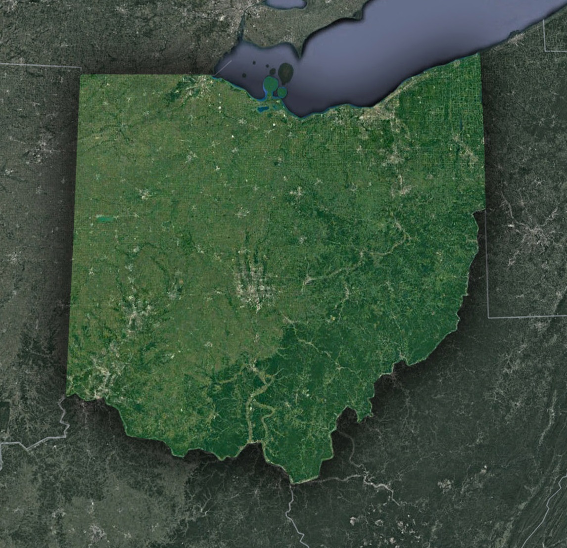
The Meandering Ohio River: Satellites capture the majesty of the Ohio River, which gracefully skirts the state’s southern border. Its sinuous bends, islands, and tributaries weave a tapestry of life and commerce. From space, the river emerges not just as a water body, but as Ohio’s pulsating artery.
Columbus’s Urban Web: The state capital, Columbus, showcases a sprawling urban expanse. From above, its streets, parks, and the Scioto River render a mesmerizing pattern, telling tales of development, heritage, and community spirit.
The Shores of Lake Erie: Ohio’s northern boundary is graced by Lake Erie, one of the Great Lakes. Satellite imagery offers a pristine view of its blue expanse, juxtaposed against the greenery of Ohio. The lake’s harbors, beaches, and islands, like Kelleys and South Bass, emerge as nature’s masterpieces.
The Greenery of Cuyahoga Valley: Between Akron and Cleveland lies a green haven – the Cuyahoga Valley National Park. From space, this reserve emerges as a verdant patchwork of forests, fields, and the winding Cuyahoga River.
Practical Uses of Satellite Imagery in Ohio
Beyond beauty, satellite views serve numerous functional purposes:
Agriculture: With Ohio being a significant agricultural state, farmers employ satellite data to monitor crop health, optimize irrigation, and detect pests.
Environmental Conservation: The imagery aids in monitoring forests, wetlands, and watersheds, ensuring sustainable use and conservation.
Urban Planning: As cities like Cincinnati expand, planners use satellite data to ensure sustainable growth, balancing infrastructure with green spaces.
Disaster Management: Real-time satellite data assists in predicting and managing potential threats like floods, especially along the Ohio River.
Peeking Ahead: Satellites and Ohio’s Future
As satellite technology advances, offering hyper-spectral imaging and real-time tracking, Ohio stands to benefit immensely:
Water Quality Monitoring: Lake Erie, which occasionally faces issues like algal blooms, can be continuously monitored for water quality, ensuring public health and marine life safety.
Infrastructure Development: Real-time imaging can aid in the strategic expansion of highways, bridges, and public transportation, keeping Ohio connected and robust.
Ohio’s Satellite Ode
Ohio, often termed the “Heart of It All”, truly embodies a blend of nature and development. Through satellite lenses, we appreciate its patchwork of farms, the rhythmic flow of its rivers, and the vibrant pulse of its cities.
So whether you’re cruising along the Ohio Turnpike or savoring a sunset by Lake Erie, remember that from space, Ohio emerges as a brilliant tapestry of landscapes and life. And in this cosmic view, every road, river, and rooftop tells a story of a state that shines brightly, no matter the perspective.
Check out WhiteClouds’ 3D Maps for more information on satellite maps of Ohio. 2D Canvas Print Satellite Maps of Ohio are also available.
Contact us today to learn more about our 3D services and how we can help you achieve your goals.