
New Mexico’s Grandeur: A Celestial Exploration of the Land of Enchantment
Beneath the vast expanse of the cosmos, New Mexico unfurls as a tapestry of intricate beauty and history. The “Land of Enchantment” is an apt moniker, but have you ever wondered how enchanting New Mexico appears from outer space? Join us on this satellite sojourn over New Mexico and rediscover its magic from an ethereal vantage.
The Satellites’ Odyssey
Satellites, our celestial sentinels, sweep the globe, capturing images that bridge the chasm between science and art. With every pixel, they narrate tales of landscapes and epochs. When their lenses focus on New Mexico, they illuminate a world of deserts, mountains, and vibrant human imprints.
New Mexico Unveiled: Satellite Chronicles
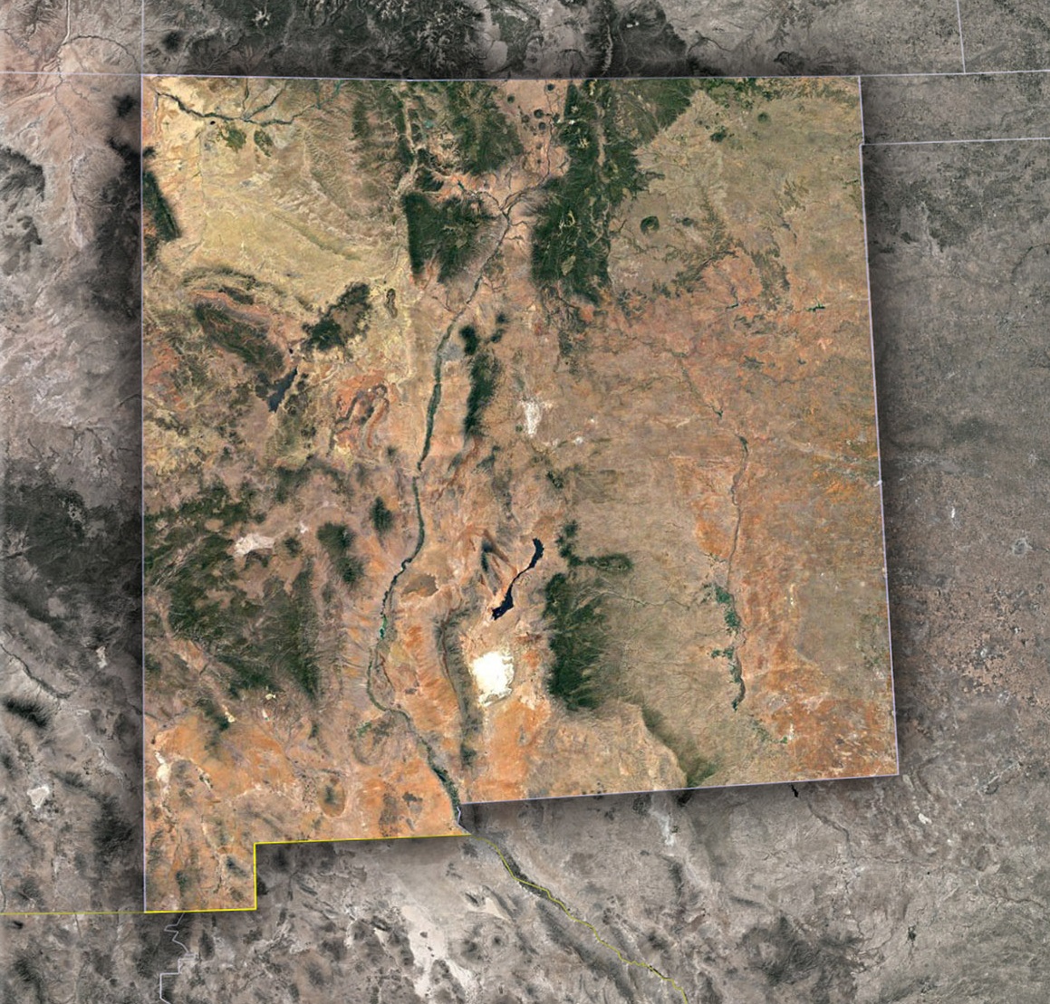
The Chihuahuan Desert-An Artist’s Palette from Above: Encompassing a significant portion of southern New Mexico, the Chihuahuan Desert reveals itself as a masterful canvas painted with gradients of sand, rocky outcrops, and occasionally dotted with vegetation. This vast desert, when observed from the satellite’s celestial vantage point, is an artistry of sandy hues intertwined with jagged mountain silhouettes. After the rare and cherished moments of rainfall, temporary lakes or playas emerge, shimmering momentarily. These ephemeral water bodies resemble mirrors strategically placed by nature, catching the sun’s rays and reflecting a dazzle that’s visible even from space.
Rio Grande-The Lifeline of New Mexico’s Landscape: Acting as the primary artery in the heart of this arid land, the Rio Grande River traces a serpentine path, snaking its way through the desert and acting as the fountain of life for numerous ecosystems. With a bird’s eye view provided by satellites, observers can follow its labyrinthine journey, watching as it breathes life into the parched earth, sustaining cities, Pueblo settlements, and diverse fauna. This river, throughout history, has been a silent witness to the evolution of civilizations, wars, and migrations.
Santa Fe to Albuquerque-The Dual Jewels of the Desert: Emerging like oases in the desert are the cities of Santa Fe and Albuquerque, each radiant with its unique charm and history. Santa Fe, with its sprawling adobe structures and serpentine streets, is a living museum of the past, where the echoes of ancient civilizations reverberate in its architecture and alleyways. Albuquerque, on the other hand, presents a more modern facet, with its organized grid-like layout, yet it too holds the weight of history. Both cities, from a satellite’s gaze, are like gems embedded in the rough desert canvas, narrating stories of resilience, adaptability, and the harmonious blend of the old with the new.
The White Sands-New Mexico’s Gleaming Mystery: Among the diverse landscapes that New Mexico boasts, the White Sands National Park is undeniably one of the most mystifying. This vast expanse of dazzling white gypsum dunes looks like a patch of snow in the desert or a dreamy landscape from a fantastical realm. When satellites capture this marvel, the dunes radiate an almost ethereal glow, standing in stark, brilliant contrast to the surrounding golden-brown desert, presenting a spectacle that beckons questions about its origins and survival.
Shiprock-The Guardian of the Desert Skies: In the northwest, breaking the monotony of the desert horizon, rises Shiprock. This massive rock formation, revered and considered sacred by the Navajo people, is not just a geographical wonder but also a symbol of the region’s rich cultural tapestry. From an aerial perspective, Shiprock stands tall, casting long, dramatic shadows that sweep across the desert floor. It’s a silent sentinel, a testament not only to the region’s volcanic past but also to the countless legends, stories, and spiritual beliefs it inspires in the hearts of those who know its significance.
Beyond Beauty: Satellites Serving New Mexico
The panoramic views satellites offer are not just for aesthetic appreciation; they drive crucial insights:
- Water Management: In arid regions, monitoring reservoir levels, river flows, and groundwater reserves is crucial. Satellite imagery helps manage this precious resource more effectively.
- Agriculture: Despite the desert climate, areas of New Mexico are agriculturally rich. Satellite data aids farmers in optimizing irrigation, predicting potential infestations, and improving crop yields.
- Urban Planning: Growth areas like Las Cruces can utilize satellite insights for sustainable expansion, ensuring green spaces and cultural landmarks are preserved.
- Forest and Fire Management: Regions like the Lincoln National Forest benefit from the satellites’ watchful eyes, detecting early signs of wildfires and aiding in conservation efforts.
Satellites of Tomorrow: New Mexico’s Cosmic Dance Continues
The future promises innovations:
- Climate Monitoring: As global temperatures fluctuate, it’s crucial to monitor New Mexico’s deserts and mountains for climate-driven changes.
- Cultural Conservation: Satellites can help track and protect historical and Indigenous sites from erosion, vandalism, or encroachment.
Reflecting on New Mexico’s Satellite Symphony
Through the lens of advanced technology, New Mexico’s spirit pulses vividly. Every dune shift in the White Sands, every ebb in the Rio Grande, every sunrise over the Organ Mountains—they’re all moments in New Mexico’s celestial ballet.
As you tread its paths, from the ancient corridors of Taos Pueblo to the Roswell’s extraterrestrial mysteries, always remember: above, satellites dance in synchrony, capturing the ever-evolving rhythm of the Land of Enchantment. Through their unblinking gaze, New Mexico is not just a state; it’s a vibrant saga painted on the canvas of the cosmos.
Check out WhiteClouds’ 3D Maps for more information on satellite maps of New Mexico. 2D Canvas Print Satellite Maps of New Mexico are also available.

Contact us today to learn more about our 3D services and how we can help you achieve your goals.