
A Celestial Perspective: New Jersey from the Sky
When thinking of New Jersey, many envision the bustling streets of Newark, the coastal wonders of the Jersey Shore, or the lush expanses of the Pine Barrens. But what if we shifted our gaze upwards and experienced the Garden State from a bird’s eye, or rather, a satellite’s eye view? Welcome to New Jersey as you’ve never seen it before, through the lens of advanced satellite technology!
Ascending Above: Why Satellites?
Satellites, our silent voyagers in space, have transformed our understanding of Earth. Their ever-watchful eyes capture every nook and cranny, allowing us to appreciate the detailed tapestry of our world. In the case of New Jersey, this celestial view reveals a dynamic blend of urban sprawl, verdant landscapes, and intricate waterways.
The Satellite’s Panorama-New Jersey in Vivid Detail
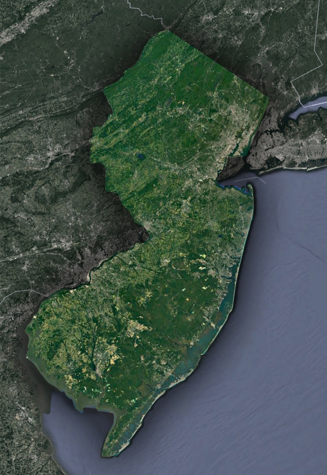
The Atlantic Coastline-Nature’s Melodic Dance: Stretching gracefully from Sandy Hook all the way to the historic Cape May, the New Jersey coastline is a breathtaking blend of pristine sandy expanses, bustling boardwalks teeming with life, and tranquil estuaries that provide sanctuary to diverse marine life. Through the discerning lens of a satellite, one can truly grasp the delicate balance of human endeavors harmoniously coexisting with the majestic undulations of the Atlantic Ocean.
The Pine Barrens-An Enigmatic Green Tapestry: The Pine Barrens, a sprawling forested realm that accounts for nearly a quarter of New Jersey’s land, is not just a vast stretch of trees. From a bird’s eye view, the rich tapestry of meandering rivers, babbling streams, and mysterious cedar swamps unfurls. This intricate network becomes beautifully pronounced, revealing a dynamic ecosystem that forms New Jersey’s verdant heart.
Urban Dynamics and Threads of Civilization: From the satellite’s vantage point, the dense urban clusters of New Jersey, stretching from the bustling heart of Jersey City to the historic corridors of Trenton, manifest as elaborate labyrinths. These intricate patterns of roads weaving through buildings, interspersed with pockets of lush green, tell stories of centuries of human settlement, growth, and the relentless march of progress.
The Delaware River-Nature’s Winding Masterpiece: Acting as the defining western boundary, the Delaware River charts a mesmerizing course, its sinuous curves carving out a natural demarcation with neighboring Pennsylvania. This aquatic journey, with its ebbs, flows, and intricate dance, is a sight to behold, especially when observed from the heavens.
Agricultural Jewels-Embodying the Spirit of the Garden State: Amid the dominance of urban sprawl, New Jersey’s verdant farmlands stand as silent reminders of its agricultural roots and rich legacy. These patches, dotted with flourishing orchards, vibrant vineyards, and geometrically pleasing crop circles, provide a stark contrast to the concrete jungles, underscoring the reason behind New Jersey’s endearing moniker – the Garden State.
While urban areas dominate, patches of farmland remind us why New Jersey is called the Garden State. Orchards, vineyards, and crop circles paint a different kind of urban landscape.
Beyond Beauty: The Utility of Satellite Imagery
- Monitoring Coastal Erosion: The Jersey Shore, constantly reshaped by nature, requires vigilant monitoring. Satellites help track changes, guiding coastal preservation efforts.
- Urban Planning and Expansion: Satellite data is invaluable for city developers, ensuring sustainable growth while preserving green corridors.
- Wetlands Conservation: The Meadowlands and other wetlands are vital ecosystems. Satellite imagery aids in monitoring health and human impact on these areas.
- Traffic Flow and Infrastructure Development: Satellites assist in identifying traffic hotspots, guiding infrastructural decisions to ease congestion, especially in dense corridors like the I-95.
Glimpsing the Future: Satellites and New Jersey’s Tomorrow
- Climate Change Monitoring: Sea level rise and changing weather patterns will impact New Jersey. Satellites will play a pivotal role in monitoring and mitigation.
- Preservation of Heritage Sites: Historical sites, from Revolutionary War battlegrounds to ancient Indigenous areas, can be monitored for conservation.
- Renewable Energy Infrastructure: As New Jersey leans into renewable energy, satellites can aid in optimal placement of wind turbines and solar farms.
The Cosmic Dance: New Jersey and Beyond
The art of satellite imagery allows us to appreciate New Jersey from a fresh perspective. Every highway’s stretch, every beach’s curve, and every forest’s shadow captures the state’s essence. It’s a symphony of nature and human endeavor.When you next stroll along the Hudson River, hike in the Kittatinny Mountains, or relax on a Long Beach Island shore, remember the celestial dance occurring miles above. Satellites don’t just capture images; they capture stories. In the case of New Jersey, it’s a tale of diversity, resilience, and beauty. Through the satellite’s gaze, New Jersey isn’t just a state on the map; it’s poetry in pixels.
Check out WhiteClouds’ 3D Maps for more information on satellite maps of New Jersey. 2D Canvas Print Satellite Maps of New Jersey are also available.
Contact us today to learn more about our 3D services and how we can help you achieve your goals.