
The Satellite Map: Unlocking Nebraska’s Secrets
Before we embark on this mesmerizing journey across Nebraska, it’s essential to acquaint ourselves with the tool illuminating our path – the satellite map. This isn’t just another map; it represents the pinnacle of technological advancement and human curiosity. Hovering thousands of miles above us, satellites with state-of-the-art cameras and sensors sweep across our planet, collecting vast amounts of data.
These images, while breathtaking, aren’t mere snapshots. They’re intricate compilations of multi-spectral data, capturing not only what’s visible to the human eye but also revealing the unseen. From the heat radiated by cityscapes to the delicate water flows in hidden creeks, satellite imagery brings forward Earth’s secrets in unparalleled detail.
One might ponder how these differ from the maps of yesteryears. Traditional maps, while invaluable for navigation and reference, can’t encapsulate the dynamic nature of our world. Satellite maps, however, are a living testament to the ever-evolving landscapes, capturing real-time events like the shift of sand dunes or the growth of urban areas. Moreover, the depth, clarity, and precision offered by these maps are unmatched, turning even the most familiar terrains into artworks of topographical brilliance.
With Nebraska as our canvas, the satellite map will be our lens, offering a fresh perspective on a state that’s as rich in history as it is in geographical wonders. Armed with this knowledge, let’s dive deep into the heartland of America.
Nebraska Unveiled: A Satellite Odyssey Through ‘The Cornhusker State
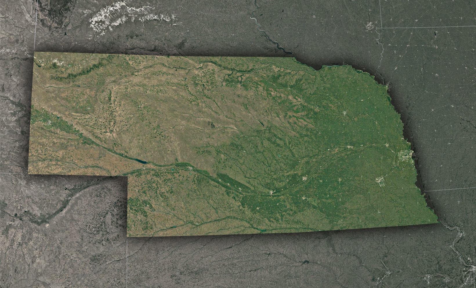
Nebraska, known as ‘The Cornhusker State’, portrays a stunning blend of sprawling plains, meandering rivers, and animated cities. As we journey through this celestial tour, the multifaceted tapestry of Nebraska reveals itself with intricate precision.
The Platte River’s Tapestry: Nebraska’s lifeblood, the Platte River, gleams like a fluid jewel from the expanse above. This essential waterway threads its way through the state, enriching both nature and agriculture. Its intricate web of tributaries paints a beautiful hydrological masterpiece, underlining the river’s ecological importance.
Sweeping Sandhills: Journey further, and you’ll encounter the unique Sandhills, a vast region of grass-stabilized sand dunes. The satellite perspective unveils this region’s undulating beauty, a blend of greenery and golden sands, bearing testament to the ever-changing forces of nature.
Cityscapes: Omaha and Lincoln: In juxtaposition to Nebraska’s natural splendors, its urban centers, primarily Omaha and Lincoln, emerge as vibrant patches of civilization. From space, the detailed urban layouts of roads, buildings, parks, and water bodies depict the organized chaos and vitality of these bustling cities.
Agricultural Mosaics: Nebraska’s agricultural prowess unveils itself as a myriad of geometric patterns. Expansive corn and soybean fields, punctuated by pastures and small woodlands, create a checkerboard of varying hues, reflecting the state’s agricultural dominance.
Wild Prairie Landscapes: The untouched prairies of Nebraska form a verdant sea, swaying with native grasses and wildflowers. The satellite view captures this region’s serene beauty, representing a throwback to the landscapes that once covered much of the American heartland.
The Niobrara’s Secrets: The Niobrara River, with its scenic valleys and diverse ecosystems, offers a rich visual treat from above. Its meanders, waterfalls, and verdant banks are etched clearly against the state’s topography, highlighting its significance as a natural sanctuary.
Echoes of History from Above: Nebraska’s rich history, from its Native American roots to the Oregon Trail, leaves its marks on the land. Distinct trails, historic forts, and ancient pathways are subtly visible, narrating tales of early settlers, exploration, and indigenous cultures.
Through the lens of satellite imagery, Nebraska’s geographical and cultural essence comes alive. From its fertile plains to urban centers, every pixel and pattern narrates a tale of resilience, innovation, and nature’s wonders.
Check out WhiteClouds’ 3D Maps for more information on satellite maps of Nebraska. 2D Canvas Print Satellite Maps of Nebraska are also available.
Contact us today to learn more about our 3D services and how we can help you achieve your goals.