
The Satellite Map of Montana: A Skyward Journey Over the Treasure State
Amidst the vast expanse of the American West lies Montana, a state steeped in natural grandeur and storied history. Known for its sweeping plains, rugged mountains, and pristine lakes, Montana offers a visual symphony for anyone fortunate enough to visit. But have you ever wondered how this magnificent state looks from the heavens above? Through the lens of satellite mapping, we’re about to embark on an aerial exploration of Montana like never before.
Unraveling Satellite Mapping
Before our skyward journey over Big Sky Country, it’s crucial to understand the magic behind satellite mapping. This sophisticated technology leverages satellites orbiting Earth, capturing intricate, high-resolution images. When these images are seamlessly stitched together, they provide a holistic, visual representation of vast landscapes. For geographers, nature enthusiasts, and the curious-minded, satellite maps offer an unparalleled perspective on our world.
Montana Unveiled from Above
From space, Montana unfolds as a land of contrasts and beauty:
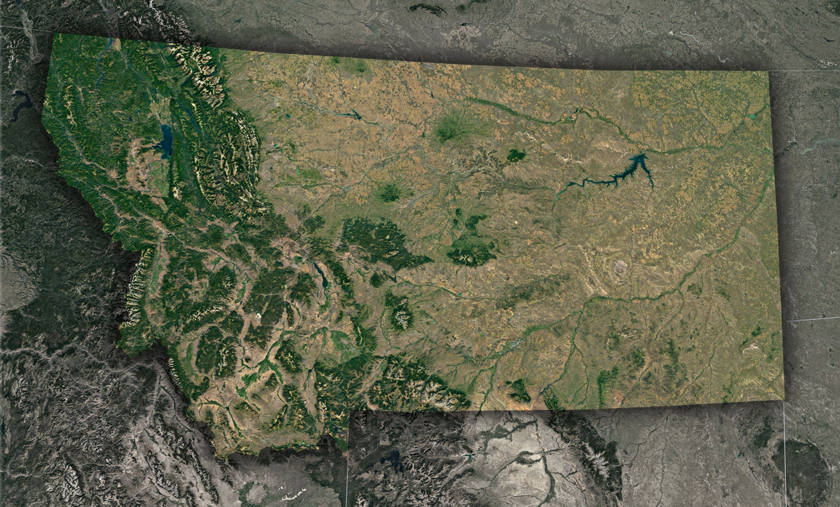
- Rocky Mountain Ranges: Stretching across the westernmost part of Montana, the Rocky Mountains aren’t just a singular, monolithic range but rather an intricate collection of various subranges, each with its own unique geological narrative and ancient history. These subranges, which encompass areas from the Bitterroots to the Madisons, not only offer a visual treat for those looking at the state from the ground but also present a stunning tableau when viewed from above, especially through satellite imagery. The sheer magnitude of these towering peaks, combined with their varying elevations and terrains, casts long, dramatic shadows across Montana’s landscape. Each peak, ridge, and valley tells a story—some speak of tectonic movements from ages past, while others recount tales of the ice and snow that once cloaked them. The satellite view captures this majestic splendor, offering a panoramic understanding of their geographical significance and beauty.
- Montana’s Expansive Plains: As one’s gaze drifts eastward from the Rocky Mountain ranges, a transformation in the topography is evident. The rugged, mountainous terrain slowly descends, making way for the sprawling vastness of the Great Plains. This expansive stretch of land, vast and seemingly endless, presents a mesmerizing spectacle from the sky, reminiscent of a patchwork quilt intricately woven with myriad colors and textures. The plains’ formation is a result of countless years of natural processes at work. Over millennia, the relentless forces of wind, the erosive power of water, and the sculpting hands of glacial movements have come together to craft this stunning landscape. It’s a region that speaks to the perseverance of nature, the passage of time, and the ever-evolving face of our planet.
- Montana’s Remarkable Hydrological Wonders: Dive deeper into Montana’s geographical tapestry, and one finds that it is very much a land defined by its waters. Montana boasts a rich hydrological network, with the mighty Missouri River meandering gracefully through its expanses, carving valleys and nurturing ecosystems in its wake. But it’s not just this renowned river that stands out. Montana is home to Flathead Lake, a shimmering expanse of freshwater that holds the distinction of being the largest of its kind west of the Mississippi. This lake, with its crystal-clear waters, serves as a vital habitat for numerous species and offers recreational opportunities for locals and visitors alike. Alongside these water giants, Montana’s terrain is dotted with countless smaller rivers, streams, and lakes. Each of these water bodies, whether vast or petite, glistens under the sun, presenting an aerial view reminiscent of jewels scattered against a backdrop of green and brown. They not only enrich the state’s natural beauty but also play a pivotal role in sustaining life and shaping Montana’s diverse ecosystems.
Narratives Narrated by Satellites
- Natural Wilderness: Satellite imagery brings to light the vast untouched expanses of Montana. Places like the Bob Marshall Wilderness stand out, reminding viewers of America’s wild spaces.
- Agricultural Legacy: The patchwork patterns of eastern Montana are testimony to the state’s agricultural backbone. Here, from miles above, we see fields of wheat, barley, and hay come alive in varying shades.
- Fire and Regrowth: Recent years have seen Montana grapple with forest fires. Through satellite views, we can observe the charred scars of past fires and the brave green of regrowth, showcasing nature’s resilience.
The Profound Impact of Satellite Perspectives
Beyond their sheer visual splendor, these bird’s-eye views of Montana serve multiple essential purposes:
- Environmental Monitoring: Satellite imagery is invaluable in tracking changes in land use, deforestation, river paths, and the impacts of climate change. With Montana’s diverse ecosystems, this data is crucial for conservation.
- Urban Development: While Montana is predominantly rural, cities like Billings, Missoula, and Bozeman are growing. Satellite maps provide insights into urban sprawl, infrastructure development, and planning needs.
- Historical and Cultural Exploration: Satellite views also reveal traces of Montana’s past, from ancient indigenous sites to historic trade routes and trails.
Your Virtual Expedition
With technology at our fingertips, the awe-inspiring vistas of satellite imagery are available to anyone with an internet connection. Multiple platforms provide detailed satellite maps of Montana, allowing users to zoom, pan, and traverse the state from above. Whether it’s a virtual hike through Glacier National Park, a flight over the plains of eastern Montana, or a descent into the Bitterroot Valley, the sky is literally the limit.
Montana, celebrated as the Treasure State, offers even more riches when viewed from above. Satellite mapping of Montana doesn’t just offer a visual feast; it bridges the gap between technology and nature, past and present, and challenges and opportunities. As we conclude our celestial journey, it becomes evident that satellite views don’t diminish Montana’s grandeur – they amplify it, casting the state in a light both fresh and timeless.
Check out WhiteClouds’ 3D Maps for more information on satellite maps of Montana. 2D Canvas Print Satellite Maps of Montana are also available.
Contact us today to learn more about our 3D services and how we can help you achieve your goals.