
The Satellite Map of Louisiana: A Bird’s-Eye View of the Bayou State
Louisiana, known for its unique blend of cultures, rich history, and vibrant landscapes, is a state that commands attention. From the lively streets of New Orleans to the extensive wetlands that sprawl its southern regions, Louisiana has no shortage of sights to see. However, to truly appreciate the beauty and intricacies of this state, one might want to take to the skies—or even further. Enter the world of satellite mapping.
Satellite Maps: An Overview
Before diving into Louisiana’s topographical wonders, it’s essential to understand the marvel of satellite mapping. This technology involves capturing images of the Earth from satellites that orbit our planet. These high-resolution photographs are then pieced together to create a detailed and comprehensive visual representation of any given area. For geographers, environmentalists, and curious minds alike, satellite maps provide invaluable insights into our ever-changing world.
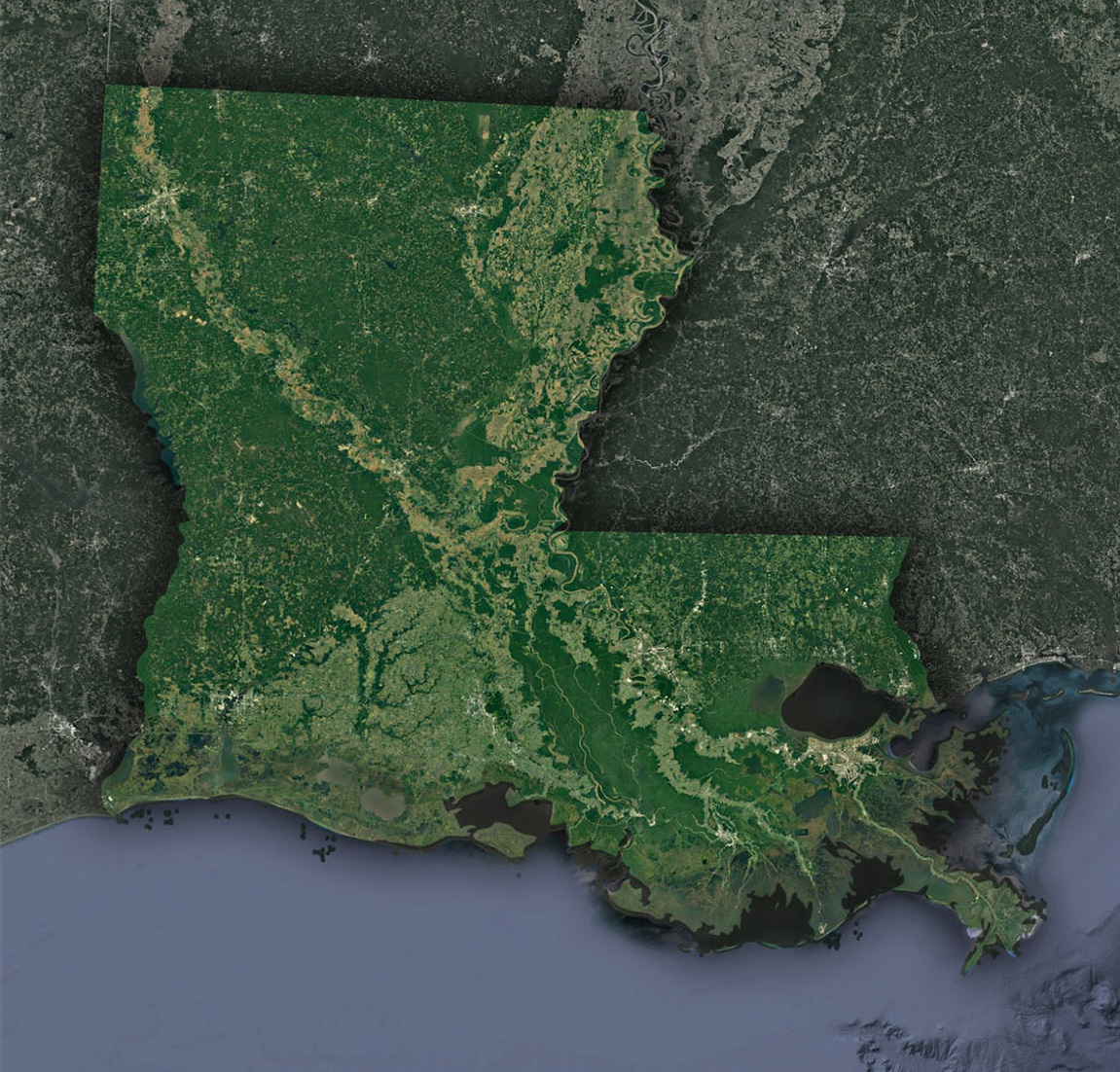
Louisiana from Above
When viewing a satellite map of Louisiana, several geographical features immediately jump out:
- The Mississippi River Delta: Louisiana’s southern tip is dominated by the sprawling Mississippi River Delta. This alluvial formation, created by centuries of sediment deposits from the mighty Mississippi, serves as a life source for the region. The waterways and wetlands here are critical habitats for a wide variety of marine life and waterfowl.
- The Wetlands: Louisiana’s moniker, “The Bayou State,” is well-earned. Satellite imagery vividly captures the vast expanse of wetlands that stretch across the southern part of the state. These wetlands, including swamps, marshes, and bayous, are vital ecosystems that support diverse flora and fauna.
- Urban Centers: The cities of Baton Rouge and New Orleans stand out prominently against the backdrop of Louisiana’s greenery. New Orleans, with its Crescent City curve, and Baton Rouge, situated further up the Mississippi River, can be identified by their dense infrastructure and proximity to significant waterways.
The Stories the Satellite Tells
- Erosion Crisis: One of the most pressing environmental issues visible from a satellite view of Louisiana is the rapid rate of coastal erosion. The state loses approximately a football field worth of land every 100 minutes. This erosion is driven by factors like sea-level rise, subsidence, and human-made disruptions like oil and gas exploration. From space, the receding coastline and the fragmented marshlands bear silent witness to this crisis.
- Hurricane Impact: The scars left by devastating hurricanes are also evident from satellite imagery. Changes in land use, deforestation, and the after-effects of floodwaters can be tracked year after year. By comparing images from different periods, one can visualize the resilience and vulnerabilities of Louisiana’s landscape.
- Agricultural Patterns: The northern and central parts of Louisiana are characterized by a patchwork of agricultural lands. From above, these areas resemble a colorful quilt, changing shades with the seasons. These satellite images provide insights into crop patterns, land use, and the state’s agrarian heartbeat.
Why Satellite Maps Matter
The significance of satellite maps extends far beyond their visual appeal. For Louisiana, they serve multiple crucial purposes:
- Disaster Management: In a state prone to hurricanes, flooding, and other natural disasters, satellite maps provide essential data for planning and response efforts.
- Conservation Efforts: By visualizing the scale of land loss, researchers and policymakers can pinpoint areas that require immediate conservation efforts. This data is crucial for preserving Louisiana’s unique ecosystems.
- Education and Awareness: For the average person, satellite maps transform abstract environmental issues into tangible visual data. They foster an appreciation for the state’s geography and the challenges it faces.
Exploring Louisiana Virtually
Today, the wonders of satellite technology are at our fingertips. Numerous online platforms offer detailed satellite imagery of Louisiana, making it easier than ever for enthusiasts to explore the state from a bird’s-eye view. By simply zooming in and out, one can traverse the dense urban jungles of New Orleans, glide over the serene waters of Lake Pontchartrain, or wander through the labyrinthine bayous of Acadiana.
Louisiana, with its intricate landscapes and dynamic ecosystems, is a gem of the American South. While its beauty is undeniable from the ground, a satellite perspective offers a fresh and enlightening view of the state’s grandeur and its vulnerabilities. As we continue to harness the power of satellite mapping, it becomes increasingly apparent that this technology not only reveals the beauty of our world but also empowers us to protect it.
Check out WhiteClouds’ 3D Maps for more information on satellite maps of Louisiana. 2D Canvas Print Satellite Maps of Louisiana are also available.
Contact us today to learn more about our 3D services and how we can help you achieve your goals.