
Kentucky From the Cosmos: An Aerial Ode to the Bluegrass State
From the echoes of thoroughbred hooves thundering down racetracks to the timeless tunes of bluegrass music, Kentucky, often termed the ‘Bluegrass State’, is a treasure trove of culture, history, and natural beauty. While its landscapes are captivating at ground level, there’s a unique thrill in witnessing Kentucky from the skies. Journey with us as we explore this enchanting state through the lens of satellite imagery.
The Lush Green Blanket: The Bluegrass Region
The central part of Kentucky, aptly named the Bluegrass Region, is distinguished by its fertile soil, manifesting as a lush green carpet when viewed from above. Satellite imagery reveals a verdant landscape, crisscrossed by countless meandering streams and dotted with the iconic horse farms for which the region is renowned. The undulating terrain and intricate patterns of fields, forests, and water bodies present a sight to behold.
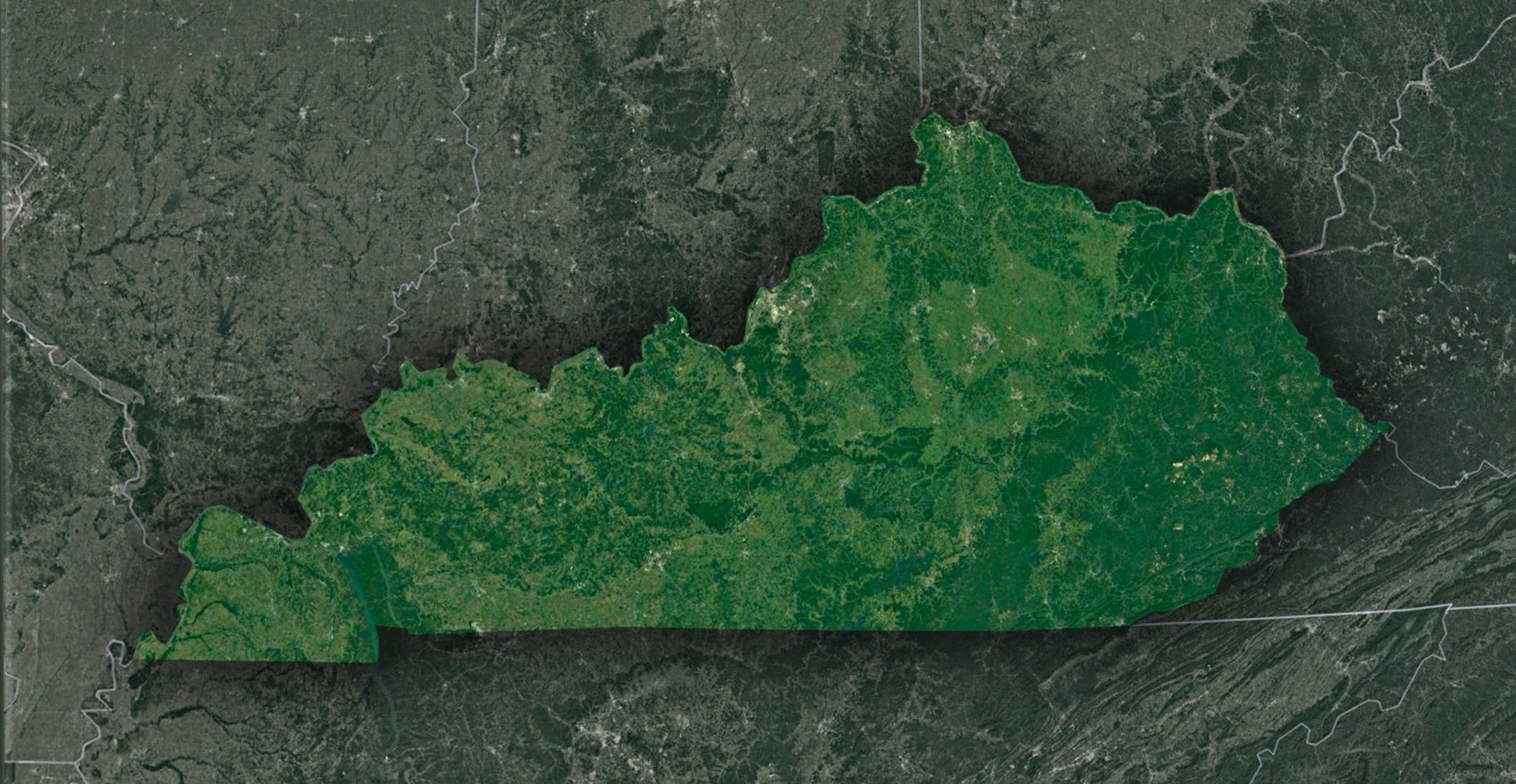
The Appalchian Tales: Cumberland Plateau
To the east, Kentucky is draped by the mighty Appalachians’ arms, particularly the Cumberland Plateau. This region is characterized by rugged hills, deep gorges, and thick forests. From space, the textures of this terrain are intensely visible, painting a vivid picture of the eons of geological forces that have sculpted this land. The Cumberland Gap, a historic gateway to the west, can be identified as a distinct notch in the mountains.
The Underground Wonder: Mammoth Cave National Park
While the world’s longest cave system is largely subterranean and hidden from satellite views, the surrounding region of the Mammoth Cave National Park offers an intriguing sight. Dense forests, the winding Green and Nolin rivers, and the unique karst topography form patterns that hint at the vast subterranean labyrinths below.
The Waterscape Tapestry: Kentucky’s Lakes and Rivers
Kentucky is adorned with numerous water bodies, and they stand out prominently in satellite images. The Kentucky Lake and Lake Barkley, with their sprawling expanse, appear like shimmering mirrors reflecting the sky. The mighty Ohio River defines the state’s northern boundary, its serpentine flow presenting a stark contrast to the adjoining landscapes. These water bodies are not just geographical features; they narrate stories of commerce, recreation, and history.
Urban Signatures: Cities and Infrastructure
From a celestial viewpoint, Kentucky’s urban centers offer intriguing insights. Louisville, with its grid-like layout and the distinct Ohio River bend, stands out prominently. Lexington, the heart of the Bluegrass Region, is identifiable by its urban sprawl amidst green expanses. The transportation networks, infrastructure developments, and even the state’s airports are visible, underlining Kentucky’s balance between modernity and tradition.
The Western Coal Fields and Jackson Purchase
In the western part of Kentucky, the satellite view unveils a different terrain altogether. The Western Coal Fields, marked by its rolling hills and patches of dark forests, is a stark reminder of the state’s coal mining legacy. Further south, the Jackson Purchase region showcases a blend of forests, farmlands, and wetlands, particularly the intricate network of waterways leading to the confluence of the Ohio and Mississippi rivers.
The Symphony of Land and Culture
Kentucky, with its blend of natural beauty and cultural richness, offers a dynamic tableau when viewed from space. Every patch of green, every winding river, and every urban cluster tells a story – of history, of nature’s wonders, and of human endeavors. Through the magic of satellite imagery, the Bluegrass State is revealed in all its multifaceted glory, beckoning explorers and dreamers alike to dive deeper into its tales and trails. Whether you’re a geographer, a history buff, or just someone captivated by nature’s artistry, Kentucky from above is a chapter you wouldn’t want to miss.
Check out WhiteClouds’ 3D Maps for more information on satellite maps of Kentucky. 2D Canvas Print Satellite Maps of Kentucky are also available.
Contact us today to learn more about our 3D services and how we can help you achieve your goals.