
The Satellite Map of Hawaii: A Heavenly View of the Paradise Islands
Floating in the vast expanse of the Pacific Ocean are the Hawaiian Islands, a verdant paradise on Earth known for its dazzling beaches, towering volcanoes, and rich cultural heritage. For many, the beauty of Hawaii can only be captured through firsthand experiences on its shores. But what if you could soar above the islands, getting a god’s-eye view? Enter the mesmerizing world of satellite mapping.
Understanding Satellite Maps
Before delving into Hawaii’s splendors from space, it’s worth understanding the wonders of satellite mapping. This technology involves the use of satellites that orbit Earth, capturing high-resolution images which are then stitched together to offer a comprehensive visual depiction of regions, continents, and entire countries. For scientists, environmentalists, and those driven by curiosity, these maps unlock a fresh perspective of our home planet.
Hawaii from the Heavens
When observed from above, the Hawaiian Islands present a tableau of color and form:
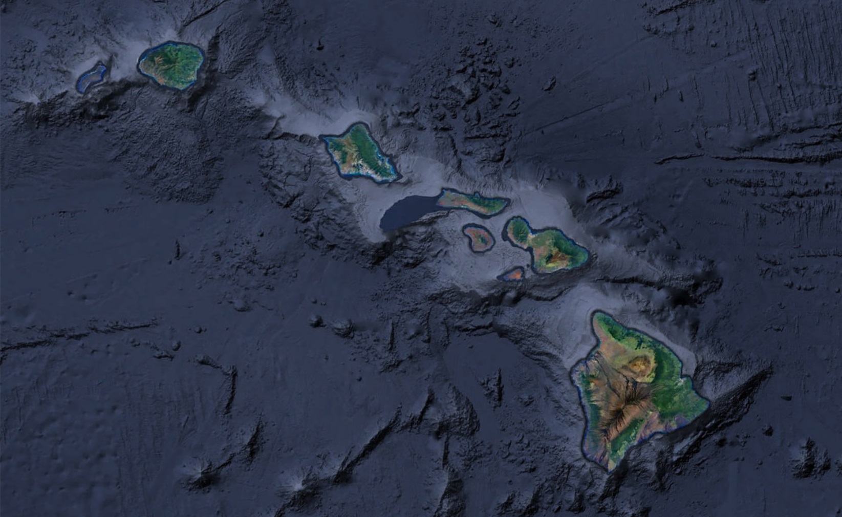
- Island Chains Explored: While many travelers and enthusiasts are familiar with popular Hawaiian destinations like Oahu and Maui, the entire archipelago offers so much more than just these celebrated gems. Comprising eight primary islands – Hawaii (often referred to as the Big Island), Maui, Oahu, Kauai, Molokai, Lanai, Niihau, and Kahoolawe – the state also includes numerous smaller islets and atolls that dot the expansive Pacific. Each island, from the vast landscapes of the Big Island to the petite crescent-shaped Molokini Crater, is a unique piece in a complex puzzle. Together, they form a magnificent mosaic that, when viewed from the vastness of space, paints a breathtaking picture of diversity, history, and natural beauty.
- Majesty of Volcanic Peaks: When one casts their eyes upon satellite images of Hawaii, certain features stand out prominently, and among the most striking are the towering peaks of Mauna Kea and Mauna Loa. Located on the Big Island, these two colossal shield volcanoes aren’t just notable for their size, but also for their significant geological and cultural implications. Mauna Kea, rising 13,796 feet above sea level, is often capped with snow, a sight that contrasts starkly with the tropical surroundings. Its peak is home to some of the world’s most advanced astronomical observatories. Mauna Loa, on the other hand, is the world’s largest volcano by volume, and its frequent eruptions have sculpted and reshaped Hawaii’s landscape for millennia. Together, these behemoths serve as a reminder of the potent natural forces that birthed and continue to shape these islands.
- The Lush Tapestry of Coral Reefs: Hawaii’s beauty isn’t confined to its landmasses. Dive (or in this case, soar) a little closer, and you’ll see the swirling hues of the archipelago’s coral reefs. These intricate underwater ecosystems appear from above as vibrant splashes and delicate tendrils of color, weaving a fabric of life around the islands. But these coral reefs are more than just a visual treat; they’re one of Hawaii’s most critical and treasured ecosystems. Serving as home to a myriad of marine species, from the nimble butterflyfish to the graceful green sea turtle, these reefs are bustling hubs of biodiversity. They act as nurseries for young fish, feeding grounds for marine animals, and protective barriers for the islands against the might of the open ocean. Satellite images beautifully capture this underwater spectacle, offering a compelling glimpse into the richness of life that thrives beneath the waves and emphasizing the need for their continued protection.
Stories Weaved by Satellites
- Volcanic Activity: Satellite imagery provides a safe and distant vantage point to observe volcanic eruptions. The dramatic lava flows from recent eruptions, like that of Kilauea, can be traced in exquisite detail, providing scientists valuable data on volcanic behavior and evolution.
- The Color Palette of Nature: From the azure of the surrounding ocean to the deep greens of the rainforests and the browns of volcanic craters, Hawaii is a showcase of nature’s hues. Satellite maps highlight this palette in spectacular resolution, allowing us to discern different terrains and ecosystems.
- Human Footprint: While much of Hawaii remains untouched, signs of urbanization, particularly in areas like Honolulu, are evident. This bird’s-eye view offers insights into how humanity has shaped the islands over centuries.
Why Satellite Views of Hawaii Are Significant
These satellite images serve more than just a visual feast. They have pragmatic applications:
- Conservation Initiatives: By highlighting areas under environmental stress, satellite maps guide conservationists to regions requiring protection or restoration.
- Disaster Management: Hawaii, being volcanic and oceanic, is prone to natural calamities like volcanic eruptions, tsunamis, and hurricanes. Satellite maps enable timely assessments and responses.
- Cultural Understanding: Ancient Hawaiians were adept at sustainable land management, evident in old agricultural terraces and fish ponds. Through satellite imagery, we can understand and appreciate these indigenous practices.
Venturing Beyond the Screen
With today’s digital advancements, the magic of satellite imagery is accessible to everyone. Numerous platforms present detailed views of the Hawaiian Islands, allowing users to embark on virtual tours. You can glide over the volcanic craters of the Big Island, trace the stunning coastlines of Kauai, or marvel at the bustling cityscape of Honolulu, all from the comfort of your home.
The Hawaiian Islands, celebrated for their terrestrial beauty, radiate an equally compelling allure when seen from space. Satellite maps not only gratify our visual senses but also offer deeper insights into the islands’ geology, ecology, and anthropological history. As we immerse ourselves in this aerial view of Hawaii, we’re reminded of the delicate balance between nature and humanity and the constant dance of creation and evolution that shapes our world.
Check out WhiteClouds’ 3D Maps for more information on satellite maps of Hawaii. 2D Canvas Print Satellite Maps of Hawaii are also available.
Contact us today to learn more about our 3D services and how we can help you achieve your goals.