
Florida From the Sky: A Satellite’s Gaze on the Sunshine State
Florida, with its sun-soaked beaches, iconic theme parks, and vast wetlands, is a destination renowned worldwide. Yet, there’s an entirely new dimension to experience when you view this peninsula from the heavens. Thanks to modern satellite imaging, the allure of Florida is laid bare in unprecedented detail. Come, journey with us as we explore Florida, not by road or sea, but from space.
Satellite Imagery: Breathing Life into Maps
A quick primer: satellite maps are not mere sketches of the Earth’s surface. They are real-time, high-resolution photographs taken from imaging satellites orbiting our planet. Google Earth, Bing Maps, and numerous other platforms have brought these mesmerizing aerial views to our fingertips, letting us embark on virtual explorations like never before.
The Sunshine State Illuminated: Key Highlights
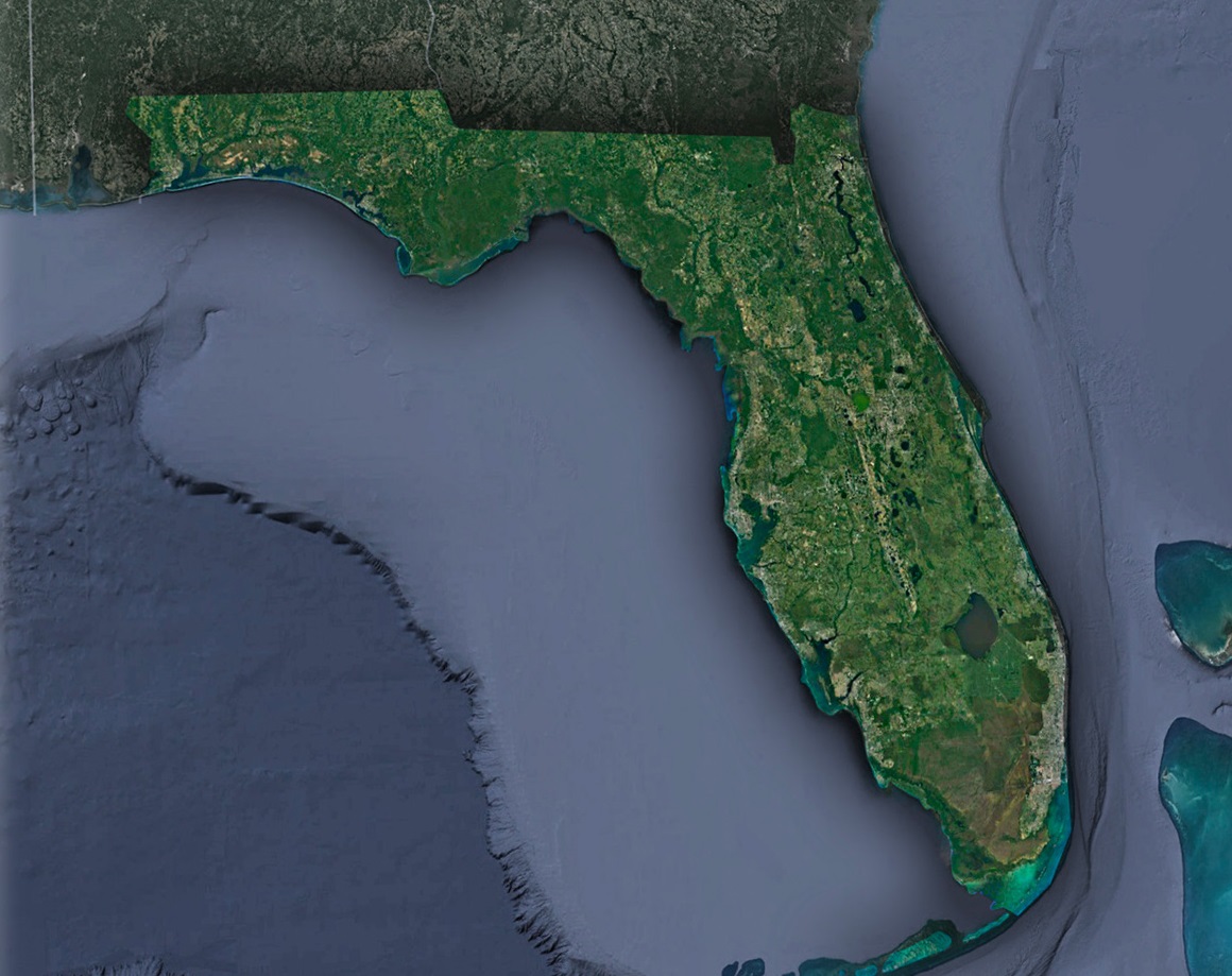
The Curved Coastlines: Florida’s peninsular shape becomes brilliantly evident from space. The state is virtually enveloped by the Gulf of Mexico to the west and the Atlantic Ocean to the east. From a satellite’s eye, the undulating coastline—with its pristine white-sand beaches, barrier islands, and coral reefs—creates a symphony of colors and textures.
Miami and the Urban Tapestry: As you sweep south on the satellite map, the vibrant hues of Miami and its surrounding cities beckon. You can identify the organized urban grid, the teal waterways of Biscayne Bay, and the tiny speckles that are boats and ships.
The Enigmatic Everglades: West of Miami and stretching south lies the expansive and wild Everglades National Park. From above, the landscape is a mosaic of wetlands, mangroves, and slow-moving water channels known as sloughs. The satellite view accentuates the importance of this ecosystem, illustrating its vastness and vulnerability.
Florida Keys: Nature’s String of Pearls: The satellite view captures the majesty of the Florida Keys archipelago in all its glory. The Overseas Highway, connecting these islands, appears like a thin line etching its way through patches of turquoise and emerald waters.
The Central Marvels: Orlando and Beyond: Central Florida is not just about Orlando’s theme parks, but from space, their vastness is palpable. Beyond them, satellite imagery showcases a mix of urban spaces, serene lakes, and the beginning of Florida’s hill country.
The Panhandle’s Unique Charm: To the northwest, the distinct shape of Florida’s Panhandle comes into view. The region is a medley of dense forests, clear-water springs, and some of the state’s most beautiful beaches, like those of Destin and Panama City.
How Satellite Imagery Benefits Florida
Beyond the sheer beauty of these images, satellite maps provide practical advantages:
Environmental Conservation: The health and changes in ecosystems, especially critical ones like the Everglades, can be monitored and studied using detailed satellite imagery.
Urban Development and Planning: Florida’s rapidly growing urban areas leverage satellite data for sustainable expansion, ensuring a balance between development and nature conservation.
Disaster Management: In a state prone to hurricanes, real-time satellite images are invaluable for monitoring storm paths, planning evacuations, and coordinating post-disaster relief.
Marine and Coastal Conservation: Satellite data aids in studying coral reefs, monitoring sea turtle nesting sites, and tracking algal blooms.
Gazing into the Future: Satellites and Florida
Satellite technology, ever-evolving, promises sharper, more frequent, and diverse data. Coupled with artificial intelligence, future insights could range from predicting urban growth trends to early detection of environmental anomalies.
The increasing accessibility of satellite data means schools, local organizations, and citizen scientists can use it for varied projects—like tracking seasonal changes in local water bodies or monitoring urban heat islands.
Wrapping up our Space-Bound Expedition
Florida, when seen from space, unveils a mix of natural splendor and human-made wonders. It’s a testament to the state’s geographical diversity and the incredible strides in technology that let us witness such beauty from a satellite’s vantage point.
As you walk Florida’s beaches, traverse its cities, or explore its wilder regions, remember there’s a celestial perspective—one that adds depth, context, and awe to our understanding of the Sunshine State. From the expanse of space, technology and nature converge, painting a dynamic portrait of Florida for all to see.
Check out WhiteClouds’ 3D Maps for more information on satellite maps of Florida. 2D Canvas Print Satellite Maps of Florida are also available.
Contact us today to learn more about our 3D services and how we can help you achieve your goals.