
Colorado Unveiled: Satellite Maps Illuminate the Centennial State
Colorado, the state of towering mountains, bustling cities, and serene plains, offers a geographical tapestry that is nothing short of breathtaking. But have you ever marveled at its beauty from space? Satellite imaging provides an astonishing perspective, revealing intricacies of the land that might otherwise go unnoticed. Join us as we soar above and delve deep into the satellite map of Colorado.
The Allure of Satellite Maps
Satellite maps aren’t just photos from space; they are powerful tools, delivering precision imagery of the earth’s surface. Through the lens of satellites, countries, states, cities, and even minute land features are captured in crisp detail. Platforms like Google Earth, NASA’s Earth Observing System, and others have democratized access, allowing us to embark on celestial journeys from our digital devices.
Colorado’s Satellite Splendor: A Region-by-Region Exploration
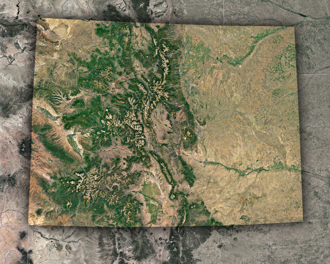
The Rocky Mountains: Nature’s Spine: Dominating Colorado’s western half is the majestic Rocky Mountain range. Satellite imagery beautifully captures the contrast of snow-capped peaks against the backdrop of green valleys. The Rockies aren’t just a uniform stretch; they’re a series of diverse ranges, including the Front Range, Sawatch Range, and San Juan Mountains, each uniquely visible from space.
Denver: The Mile-High City: Nestled on the eastern foot of the Rockies, Denver’s urban sprawl becomes evident. From a bird’s-eye view, the neatly laid streets, the geometric precision of the Denver International Airport, and the sinuous South Platte River weaving through the city come alive.
The Eastern Plains: Vastness Visualized: Beyond Denver, the terrain transitions dramatically to the flat and expansive Eastern Plains. Satellites show the subtle color gradients, from verdant green patches of farmland to the drier, golden hues of untouched prairie lands.
The Great Sand Dunes: Earth’s Natural Abstract Art: South-central Colorado houses an unexpected wonder: the Great Sand Dunes. These are the tallest dunes in North America, and from space, they appear as a mesmerizing patchwork of shadows and highlights, making it one of the satellite map’s standout features.
Colorado Plateau & Canyons: A Painter’s Palette: To the west lies the rugged terrain of the Colorado Plateau. Satellite maps beautifully delineate this area, showcasing the deep canyons, mesas, and winding rivers. This area is home to the Colorado River and its intricate, winding path, carving features like the Grand Junction and the dramatic Gore Canyon.
Technology at Play: Benefits for Colorado
The beauty on display isn’t just for admiration. Satellite imagery has had tangible benefits for the Centennial State:
Environmental Monitoring: Keeping tabs on the state’s vast forests, monitoring for wildfires, and tracking snowpack in the Rockies becomes efficient with satellite data.
Urban Development: As Colorado’s cities, especially Denver and Boulder, see rapid growth, planners use satellite imagery for sustainable development strategies.
Agriculture: The Eastern Plains, vital for farming, benefit from precision agriculture. Satellite images help monitor crop health, irrigation needs, and soil conditions.
Water Resource Management: With the Colorado River being a crucial water source, satellites play a role in tracking its flow, usage, and reservoir levels, essential for a state where water rights are a significant concern.
The Future: What’s Next for Satellite Imaging in Colorado?
The advancements in satellite technology show no signs of slowing. The future may see even more frequent and detailed imaging. Machine learning, combined with satellite data, can offer predictive insights, from forecasting avalanche risks in the Rockies to urban growth patterns in cities.
Local organizations, schools, and even citizen scientists could increasingly leverage this data. Imagine a school project where students track seasonal changes in the Maroon Bells or environmentalists monitoring the health of the state’s aspen forests.
Wrapping Up the Journey
Colorado, with its myriad landscapes, showcases the sheer power and beauty of nature. This beauty is accentuated when viewed from the heavens. From the rugged peaks of the Rockies to the serenity of its plains, satellite maps offer a unique, holistic, and profoundly awe-inspiring perspective.
So, the next time you stand atop a Colorado peak, remember there’s a satellite up above, capturing that very moment, linking the macro cosmos to your micro experience. A blend of technology and nature, revealing the interconnected beauty of our world.
Check out WhiteClouds’ 3D Maps for more information on satellite maps of Colorado. 2D Canvas Print Satellite Maps of Colorado are also available.
Contact us today to learn more about our 3D services and how we can help you achieve your goals.